
DFW airport picked up a whopping 0.00". It split the core metroplex to the northeast and southwest with nothing inbetween
Late week weather (severe and others) at least on the GFS is starting to trend more east
Texas Spring 2017
Moderator: S2k Moderators
Forum rules

The posts in this forum are NOT official forecast and should not be used as such. They are just the opinion of the poster and may or may not be backed by sound meteorological data. They are NOT endorsed by any professional institution or STORM2K.
Re: Texas Spring 2017
0 likes
The above post and any post by Ntxw is NOT an official forecast and should not be used as such. It is just the opinion of the poster and may or may not be backed by sound meteorological data. It is NOT endorsed by any professional institution including Storm2k. For official information, please refer to NWS products.
Help support Storm2K!
-
bubba hotep

- S2K Supporter

- Posts: 5457
- Joined: Wed Dec 28, 2016 1:00 am
- Location: Collin County Texas
Re: Texas Spring 2017
Brent wrote:Sure some people are having a rude awakening up in Collin County
That bang was pretty loud
Literally in and out in 5 minutes here
We took a direct hit, nice little storm with a good soaking. That makes 4 nights in a row with measurable precipitation IMBY.
Don't look now but the Euro shows 4-6" of rain for areas east of I35 over the next 10 days. Maybe it will be right this time? Also, Euro Weeklies maintain the wet cool pattern into July. Then things transition to a pretty normal summertime pattern by end of run. The image below from JB is for the entire run, if you break it down by week then it is more wet June with transition to normal during July.
https://twitter.com/BigJoeBastardi/status/866968897202917376
1 likes
Winter time post are almost exclusively focused on the DFW area.
-
bubba hotep
- S2K Supporter
- Posts: 5457
- Joined: Wed Dec 28, 2016 1:00 am
- Location: Collin County Texas
Re: Texas Spring 2017
Ntxw wrote:DFW airport picked up a whopping 0.00". It split the core metroplex to the northeast and southwest with nothing inbetween
Late week weather (severe and others) at least on the GFS is starting to trend more east
Wife said we picked up another downpour at the house and then there was a downpour that moved through downtown. It looks like the downtown cell tracked from Ft. Worth, south of the airport and into Dallas. The airport can't buy any rain lol
On this weekend, it's hard to describe how bad the GFS has been here lately. The Euro has insane CAPE across DFW Saturday before firing storms.
0 likes
Winter time post are almost exclusively focused on the DFW area.
-
Brent
- S2K Supporter
- Posts: 37092
- Age: 35
- Joined: Sun May 16, 2004 10:30 pm
- Location: Tulsa Oklahoma
- Contact:
Re: Texas Spring 2017
bubba hotep wrote:Ntxw wrote:DFW airport picked up a whopping 0.00". It split the core metroplex to the northeast and southwest with nothing inbetween
Late week weather (severe and others) at least on the GFS is starting to trend more east
Wife said we picked up another downpour at the house and then there was a downpour that moved through downtown. It looks like the downtown cell tracked from Ft. Worth, south of the airport and into Dallas. The airport can't buy any rain lol
On this weekend, it's hard to describe how bad the GFS has been here lately. The Euro has insane CAPE across DFW Saturday before firing storms.
I saw somewhere the other night the GFS verification score lately is a pathetic and embarassing 0.25

https://twitter.com/RyanMaue/status/866 ... 60/photo/1
0 likes
#neversummer
-
CaptinCrunch

- S2K Supporter
- Posts: 8569
- Age: 56
- Joined: Mon Nov 03, 2003 4:33 pm
- Location: Lake Worth, TX (Tarrant Co.)
Re: Texas Spring 2017
All the models have been flaky for a while now, EURO, Canadian, GFS, and even the Texas Tech model. But as they say garbage in is garbage out..... 
0 likes


Re: Texas Spring 2017
Well it looks as if we may be getting a bit more rain in the coming hours. Hopefully these last few days will help keep us out of a drought.
0 likes
I like weather, but it doesn't like me back.
Re: Texas Spring 2017
It feels like early October outside  . Fall is only one season away
3 likes
The above post and any post by Ntxw is NOT an official forecast and should not be used as such. It is just the opinion of the poster and may or may not be backed by sound meteorological data. It is NOT endorsed by any professional institution including Storm2k. For official information, please refer to NWS products.
Help support Storm2K!
Help support Storm2K!
-
weatherdude1108
- Category 5

- Posts: 4172
- Joined: Tue Dec 13, 2011 1:04 pm
- Location: Northwest Austin/Cedar Park, TX
Re: Texas Spring 2017
There are a lot of clouds out right now, and temps are not all that warm. That may temper any severe threat. I'm guessing that is why there is just a 40% probability of watch issuance.

Mesoscale Discussion 0817
NWS Storm Prediction Center Norman OK
0234 PM CDT Tue May 23 2017
Areas affected...Portions of central TX
Concerning...Severe potential...Watch possible
Valid 231934Z - 232130Z
Probability of Watch Issuance...40 percent
SUMMARY...Some increase in severe potential should occur over the
next several hours, with isolated large hail and damaging winds the
main threats. Watch issuance is possible.
DISCUSSION...19Z surface analysis shows a cold front extending from
northeast to central TX, continuing into west TX. Surface pressure
falls of 2-4 mb per 2 hours across central TX ahead of the front
suggest large-scale ascent attendant to a southeastward-moving
shortwave trough over the southern High Plains is overspreading the
discussion area. Some elevated convection has recently developed
behind the front, likely associated with the shortwave trough. As
these thunderstorms move quickly east-southeastward, they will have
some potential to become surface based. Clearing ahead of the front
has allowed for diurnal heating to destabilize the airmass across
the warm sector of central TX. Latest RAP Mesoanalysis indicates
MLCAPE of 500-1000 J/kg has developed this afternoon. Further
heating may allow MLCAPE values to approach 1500 J/kg through the
peak of the diurnal heating cycle.
Northwesterly low-level winds strengthen with height, supporting
effective bulk shear values of 45-50 kt. Convective coverage and
evolution remains somewhat unclear this afternoon across central TX
and vicinity. But, consensus of short-term guidance points to an
increasing potential for supercell development over the next several
hours along and ahead of the front, with large hail and damaging
winds both possible. Depending on convective trends this afternoon,
watch issuance is possible.
..Gleason/Kerr.. 05/23/2017
0 likes
The preceding post is NOT an official forecast, and should not be used as such. It is only the opinion of the poster and may or may not be backed by sound meteorological data. It is NOT endorsed by any professional institution including storm2k.org. For Official Information please refer to the NHC and NWS products.
-
srainhoutx

- S2K Supporter
- Posts: 6919
- Age: 66
- Joined: Sun Jan 14, 2007 11:34 am
- Location: Haywood County, NC
- Contact:
Re: Texas Spring 2017
Watch for storm development along and S of the I-35 Corridor. We've been clear all day across most of SE and S Central Texas across the I-10 Corridor.
0 likes
Carla/Alicia/Jerry(In The Eye)/Michelle/Charley/Ivan/Dennis/Katrina/Rita/Wilma/Ike/Harvey
Member: National Weather Association
Wx Infinity Forums
http://wxinfinity.com/index.php
Facebook.com/WeatherInfinity
Twitter @WeatherInfinity
Member: National Weather Association
Wx Infinity Forums
http://wxinfinity.com/index.php
Facebook.com/WeatherInfinity
Twitter @WeatherInfinity
-
weatherdude1108
- Category 5
- Posts: 4172
- Joined: Tue Dec 13, 2011 1:04 pm
- Location: Northwest Austin/Cedar Park, TX
Re: Texas Spring 2017
Our forecast office mentions elevated storms behind the front, and a lot of lift to work with.
000
FXUS64 KEWX 231915
AFDEWX
Area Forecast Discussion
National Weather Service Austin/San Antonio TX
215 PM CDT Tue May 23 2017
.SHORT TERM (Tonight through Wednesday Night)...
The cold front is currently beginning to enter our CWA and is best
evident by pressure rises behind the frontal boundary. Winds ahead of
the front are already out of a northerly direction as a boundary
associated with a dying complex of storms this morning came through
the area. This will decrease our surface convergence when the actual
front makes it to the region. This should overall limit the coverage
of showers and storms for the northern Hill Country for surface based
activity. Storms will be more likely to fire across the southern
half of the region where surface winds are lighter and convergence
will be maximized. However, elevated showers and thunderstorms can be
seen on area radars to our north and this activity is developing
under the influence of strong lift as evident on water vapor
imagery. This is evidence that we will have plenty of upper support
for sustained convection later today. As the strong lift arrives, we
could also see some elevated convection behind the front as well as
any boundary layer convection that develops along the frontal
boundary. CAPE values this afternoon will be in the 2000-3000 J/kg
range with the higher values maximized across the eastern CWA. 0-6 km
shear values near 50 knots will definitely support supercellular
structures with any of the stronger activity. Large hail will
initially be the main threat from any severe thunderstorms, but there
could be some high wind reports as well especially later in the
afternoon and evening. Thunderstorm chances will end from north to
south in the late afternoon and evening.
Cooler air is expected to filter into the region behind the front as
is already evident by the near 60 degree temperatures in the Abilene
region north of the front. Lows tonight should bottom out in the 50s
for much of the area with some upper 40s even possible across low-
lying areas in the Hill Country. The only record that could be broken
tonight is Austin Bergstrom airport where the current forecast is 2
degrees under its record low. For tomorrow, clear skies will be in
place across the region with light winds. Should be nice overall,
with highs in the lower to middle 80s over much of the area.
&&
.LONG TERM (Thursday through Tuesday)...
The beginning of the long-term forecast will be dry with with
increasing temperatures. Highs on Thursday will quickly be back into
the lower 90s with even some upper 90s across the southwestern CWA.
Temperatures will even be a couple of degrees warmer on Friday as an
upper ridge builds to our south. Lows Friday morning will also be
warm, in the lower to middle 70s.
The upper air pattern will begin to shift on Saturday as a longwave
trough begins to move through the central CONUS. Should see the first
effects of this on Saturday night with some possible warm air
advection activity ahead of an approaching cold frontal boundary.
This frontal boundary will approach the CWA on Sunday and this will
bring an increase to the precip chances to the area. It looks like a
decent chance of showers and storms will remain in the area behind
the front on Memorial Day and into Tuesday as southwest flow remains
in place across the region. Will forecast 30-40 PoPs in this period
for now, but these may have to be increased over the next several
days. Instability amounts on Sunday could support some strong storms,
but this could change as we near the weekend, and will continue to
monitor the chances of stronger convection.
0 likes
The preceding post is NOT an official forecast, and should not be used as such. It is only the opinion of the poster and may or may not be backed by sound meteorological data. It is NOT endorsed by any professional institution including storm2k.org. For Official Information please refer to the NHC and NWS products.
-
Brent
- S2K Supporter
- Posts: 37092
- Age: 35
- Joined: Sun May 16, 2004 10:30 pm
- Location: Tulsa Oklahoma
- Contact:
Re: Texas Spring 2017
Ntxw wrote:It feels like early October outside
In a month the days start getting shorter...
1 likes
#neversummer


Re: Texas Spring 2017
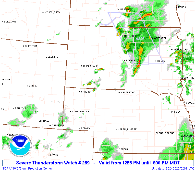
URGENT - IMMEDIATE BROADCAST REQUESTED
Severe Thunderstorm Watch Number 259
NWS Storm Prediction Center Norman OK
330 PM CDT Tue May 23 2017
The NWS Storm Prediction Center has issued a
* Severe Thunderstorm Watch for portions of
central and southeast Texas
* Effective this Tuesday afternoon and evening from 330 PM until
1100 PM CDT.
* Primary threats include...
Scattered large hail and isolated very large hail events to 2
inches in diameter possible
Scattered damaging wind gusts to 70 mph possible
SUMMARY...Scattered thunderstorms now forming across parts of
central Texas are expected to increase in coverage and intensity
while developing eastward and southeastward toward mid and upper
Texas coastal areas through this evening. Strongest activity will
be capable of producing severe hail and potentially damaging surface
gusts.
The severe thunderstorm watch area is approximately along and 80
statute miles north and south of a line from 15 miles southwest of
San Antonio TX to 50 miles south southeast of Tyler TX. For a
complete depiction of the watch see the associated watch outline
update (WOUS64 KWNS WOU9).
PRECAUTIONARY/PREPAREDNESS ACTIONS...
REMEMBER...A Severe Thunderstorm Watch means conditions are
favorable for severe thunderstorms in and close to the watch area.
Persons in these areas should be on the lookout for threatening
weather conditions and listen for later statements and possible
warnings. Severe thunderstorms can and occasionally do produce
tornadoes.
0 likes
-
Yukon Cornelius
- S2K Supporter
- Posts: 1737
- Age: 40
- Joined: Thu Dec 20, 2012 9:23 pm
- Location: Dean, TX/Westcliffe, CO
Re: Texas Spring 2017
You just cannot beat a high of 62 at the end of May. Unfortunately its going to warm up, it always seems to. Thursday, Friday and Saturday, all highs in the upper 90s with Friday nearing 100.
0 likes
#neversummer
Re: Texas Spring 2017
Upper 60s in the middle of the afternoon. The kicker is the gusting north winds..what is this?!
0 likes
The above post and any post by Ntxw is NOT an official forecast and should not be used as such. It is just the opinion of the poster and may or may not be backed by sound meteorological data. It is NOT endorsed by any professional institution including Storm2k. For official information, please refer to NWS products.
Help support Storm2K!
Help support Storm2K!
-
srainhoutx
- S2K Supporter
- Posts: 6919
- Age: 66
- Joined: Sun Jan 14, 2007 11:34 am
- Location: Haywood County, NC
- Contact:
Re: Texas Spring 2017
Will need to monitor the Memorial Day Weekend into next Wednesday for a stalling frontal boundary across Central, SE and East Texas. The ECMWF and the GFS are slowly increasing their QPF output each cycle. It appears a deep surge of Western Caribbean moisture from a wave will pool in the Western/NW Gulf near that timeframe.
2 likes
Carla/Alicia/Jerry(In The Eye)/Michelle/Charley/Ivan/Dennis/Katrina/Rita/Wilma/Ike/Harvey
Member: National Weather Association
Wx Infinity Forums
http://wxinfinity.com/index.php
Facebook.com/WeatherInfinity
Twitter @WeatherInfinity
Member: National Weather Association
Wx Infinity Forums
http://wxinfinity.com/index.php
Facebook.com/WeatherInfinity
Twitter @WeatherInfinity
-
Ralph's Weather
- S2K Supporter
- Posts: 2968
- Age: 36
- Joined: Fri Dec 13, 2013 11:55 am
- Location: Lindale, TX
Re: Texas Spring 2017
This afternoon's showers and storms have dropped over .5" at my house it appears, did not expect that much.
0 likes
Follow on Facebook at Ralph's Weather.
Re: Texas Spring 2017
Unbelievable weather for late May. Windows open and no a/c. Just had another drizzle shower here near DFW airport. Looks like another less humid day tomorrow with beautiful sunshine before some summer heat settles in for a few days. It is coming, gosh darn dang blabbitt nabbitt, it is coming. 
0 likes
-
weatherdude1108
- Category 5
- Posts: 4172
- Joined: Tue Dec 13, 2011 1:04 pm
- Location: Northwest Austin/Cedar Park, TX
Re: Texas Spring 2017
Driving home from work, sky was threatening. Dark. Looked like nighttime! Driving into my neighborhood, HUGE drops came down. 
 Hoping it would not hail. It didn't, but the rain got BLINDING, and the winds were fierce!
  Trees were swaying! Temperature dropped into the 60s.
  Lasted just a few minutes. Storm that hit us got severe-warned just to our east.
Got a free car wash!
Hoping it would not hail. It didn't, but the rain got BLINDING, and the winds were fierce! Trees were swaying! Temperature dropped into the 60s. Lasted just a few minutes. Storm that hit us got severe-warned just to our east.Got a free car wash!
1 likes
The preceding post is NOT an official forecast, and should not be used as such. It is only the opinion of the poster and may or may not be backed by sound meteorological data. It is NOT endorsed by any professional institution including storm2k.org. For Official Information please refer to the NHC and NWS products.
Re: Texas Spring 2017
Seriously, I am wearing a long sleeve t-shirt and some long legged pajama bottoms comfortably right now.......in late May!!!! An all time record!!!! Well maybe, never really kept track of that but I am sure this a first. Maybe a light jacket in the morning before work? Hmmmmm. I do dare.
0 likes
-
TheProfessor

- Professional-Met

- Posts: 3505
- Age: 27
- Joined: Tue Dec 03, 2013 10:56 am
- Location: Wichita, Kansas
Re: Texas Spring 2017
I don't know what you guys are talking about, this is perfect shorts weather. 
0 likes
An alumnus of The Ohio State University.
Your local National Weather Service office is your best source for weather information.
Your local National Weather Service office is your best source for weather information.
Return to “USA & Caribbean Weather”
Who is online
Users browsing this forum: cajungal, Ralph's Weather and 145 guests