Page 22 of 71
Re: Texas Spring 2017
Posted: Fri Mar 31, 2017 9:34 am
by gboudx
Here's an update from jeff regarding this weekend system:
Extremely active weather expected Sunday
All severe weather modes (tornadoes, large hail, and damaging winds) along with flooding rainfall possible.
Powerful upper level storm system responsible for the damaging winds across Las Vegas on Thursday will approach and then cross TX this weekend result in widespread impacts over the region. Gulf moisture begins to return in earnest later today into Saturday as the upper level low over the four corners advances into NM and then N MX. Lift begins to spread across TX late Saturday and some models try and develop strong to severe thunderstorms over the SW parts of SE TX late Saturday afternoon into the evening hours. Strong lift, very high moisture levels, and good wind energy come to bear over the region on Sunday…which is looking to very much to be a significant weather day.
While details remain low confidence at this time range factors look in place for excessive rainfall over SE TX along with a potential good severe weather threat. Warm sector air mass appears uncapped and charged with instability from roughly the very early morning hours on Sunday into Sunday evening. Potential for supercells to evolve in the warm sector air mass with latest SPC outlook suggest significant tornado parameters will be in place Sunday morning. This appears to be in response to a warm front lifting across the area early Sunday and warm fronts historically like to host tornadic supercells.
Heavy Rainfall/Flooding:
Factors certainly look to be in place for a very wet Sunday with PWS surging to 1.8 inches over the area and at least one or two boundaries in place to help focus training excessive rainfall. First boundary will be a northward advancing warm front Sunday morning with the next being an incoming surface front from W TX. Both have produced flash flood setups over SE TX before with a very deep trough approaching from the west and good upper air venting of an extremely moist surface layer with dewpoints near 70. Widespread rainfall amounts of 2-4 inches will be possible with much higher totals where any sustained cell training develops. Latest WPC outlook has areas north of I-10 already outlooked for excessive rainfall and exceedance of flash flood guidance for Sunday. Moisture profiles would certainly support excessive rainfall rates of 2-3 inches per hour.
Severe Threat:
Severe weather parameters look favorable on Sunday and potentially the highest parameters we have seen yet this winter/spring. Low level jet increases overnight Saturday into Sunday with mid level winds increasing and veering with height helping to produce good speed and directional shear over the area. Low level shear values really ramp up early Sunday morning likely due to warm front over the region and the period from about 400am-noon Sunday may feature the highest tornado risk. CAPE values of 1500-2500 J/kg over the region suggest good instability across the northward advancing warm sector and will favor intense updrafts and threat for large damaging hail and strong winds into the afternoon hours on Sunday. The tornado risk may decrease some Sunday afternoon as strong forcing along and ahead of the advancing surface front favors more of a squall line.
Confidence:
Since this event is still about 2 days away exact locations of boundaries and fully realized parameters are still in flux for Sunday. Such uncertainties result in low to moderate confidence on where exactly the heaviest rains will fall and what severe mode and when is most likely. Better confidence will hopefully arrive over the next 24 hours. For example the GFS model QPF for BUSH IAH in the last two runs has varied from 4.58 inches to 2.07 inches.
***Have a way to receive weather warnings on Sunday. Make sure WEA (wireless emergency alerts) are “on” on your cell phone…this will tone your phone if a warning is issued for your location or you drive into a warning polygon***
Re: Texas Spring 2017
Posted: Fri Mar 31, 2017 11:04 am
by Ntxw
This coming system the next few days does look much more promising for widespread rainfall. Areas along the I-10 corridor and nearby looks to be greatest risk for a severe weather outbreak

Re: Texas Spring 2017
Posted: Fri Mar 31, 2017 11:11 am
by TeamPlayersBlue
Not sure if ive seen soundings like this for my neck of the woods. Being this close to the coast and all.
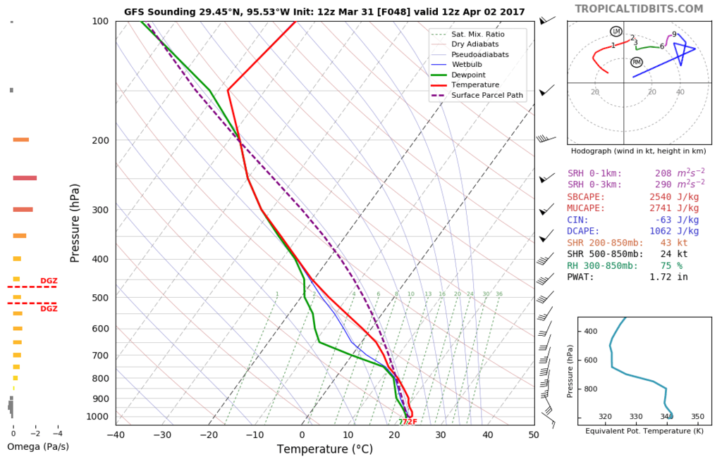
Looking again now, @54 hours seems worse than this one. Higher CAPE values.
Re: Texas Spring 2017
Posted: Fri Mar 31, 2017 11:12 am
by bubba hotep
This is looking more and more like an I20 Special

Re: Texas Spring 2017
Posted: Fri Mar 31, 2017 11:12 am
by Ntxw
Interestingly the system after this could send down a below normal air mass, for April. 40s for lows 50s/60s for highs but that's a little ways out.
Re: Texas Spring 2017
Posted: Fri Mar 31, 2017 1:04 pm
by weatherdude1108
Re: Texas Spring 2017
Posted: Fri Mar 31, 2017 3:09 pm
by bubba hotep
So here is the final outlook for April:
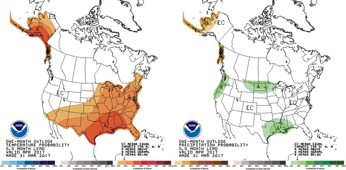
But then this doesn't really seem to add up, esp. with next week being dry after the weekend system:
Re: Texas Spring 2017
Posted: Fri Mar 31, 2017 3:36 pm
by weatherdude1108
This is a more technical discussion per usual from the EWX office this afternoon. Felt like I was in class.

Anyway.
FXUS64 KEWX 312013
AFDEWX
Area Forecast Discussion
National Weather Service Austin/San Antonio TX
313 PM CDT Fri Mar 31 2017
.DISCUSSION...
Clear skies are in place across South-Central Texas this afternoon
with temperatures in the middle to upper 80s as dry air remains in
place across the region. However, changes are beginning across the
area as breezy southerly winds are in place in response to surface
troughing northwest of the CWA. This surface cyclogenesis is in
response to an approaching upper level low pressure system currently
nearing western New Mexico. We will definitely be visibly seeing
these changes by morning as nocturnal stratus is once again expected
to develop. Lows tonight will only drop into the 60s as the breezy
southerly winds and cloud cover prevent much cooling compared to
recent nights.
By tomorrow afternoon, the center of the closed upper low will be in
southern New Mexico and we should begin to see some of the effects
of the system across the region. The first response we should see is
continued warm-air advection in the low levels of the atmosphere. We
can see this advection clearly as isentropic lift on several theta-e
surfaces from 300K extending up to 310K. What is isentropic lift or
ascent? Well, pressure surfaces are actually not flat surfaces in the
atmosphere as they vary spatially, hence high and low pressure. And
therefore, looking at wind fields on pressure surfaces does not
always give you a clear picture of how things are advecting. We can
use constant theta (potential temperature) surfaces to track low
level lift on these isentropic planes. For instance, tomorrow
afternoon's 300K surface shows the 300k level coincident with the 890
mb pressure level for Bexar County and near 840 mb over Waco. So
this gives us a natural tilt upwards in the atmosphere along the I-35
corridor. Now we just need winds along this corridor to also be
going north up this surface to allow the air parcels to also rise
upwards and provide lift for convective initiation. Looking at the
model guidance we can see southerly winds in the 30 knot range on the
same 300K surface which is more than substantial enough for
convective initiation if there is moisture and instability also
present. One way we can measure the moisture on this level is the
condensation pressure deficit. This basically means how many mb does
a parcel have to rise before it condensates. Over our area this is
about 10 to 20 mb and it is less for areas to our north. With plenty
of elevated instability to work with and the 10-20 mb deficits, this
should be enough for these parcels to convect given the instability
and lift for scattered shower development mainly along an axis from
the I-35 corridor and points west. With the better moisture to our
north, this area is expected to see somewhat of a higher
concentration of activity.
Given that we know we have the possibility of storms on Saturday
afternoon, we can look at the chances of severe storms. Parcels
lifted from 800 mb will have up to 2,000 J/kg of CAPE to work with
with ample deep layer shear. There is the presence of a mid-level
CAP that could inhibit deep convection, but think there are decent
chances we can break through the inversion near 650 mb. With any
elevated storm, the best chances for severe storms will be hail, but
with sufficient surface moisture and instability, storms initially
elevated could eventually become rooted in the boundary layer. If
this were to occur some damaging winds or an isolated tornado would
be possible. Although there is a chance for this, overall
probabilities are low, therefore there is only a marginal risk of
severe storms for tomorrow afternoon for the area.
Saturday night, we should see more significant forcing from the upper
low arrive initially to the western CWA after midnight. At the same
time the cold front will also be arriving which will provide a focus
for thunderstorm initiation. Think storms will begin as isolated
strong to severe storms in the western counties before possibly
congealing into a line of storms as the front moves east across the
area. The potential line should be somewhere around Highway 83 by
sunrise Sunday and then continue to move east through the morning and
early afternoon hours. Hail and damaging winds would be the main
threats for severe weather with this line, but an isolated tornado
could also not be ruled out. We will have to watch for any
development of isolated storms ahead of any line as the environment
across mainly the eastern counties would be more conducive for
possible tornadoes from these types of storms. SPC has an enhanced
risk in their Day 3 outlook for points east of a Williamson to
Guadalupe to DeWitt County line to cover this threat. Based on the
ECMWF, storms should exit the CWA in the early afternoon hours as
the dry slot moves into the area, but some wrap around precip is
possible Sunday evening. [b]Overall rainfall totals through Sunday
evening should be in the 1-2 inch range with isolated amounts
reaching 3 inches. The higher totals should primarily be across the
northern half of the area. Northwest winds will filter into the area Sunday night and we should
see precip end then as well.
Low temperatures Monday and Tuesday
will be back into the 50s with the cooler air in place. High
temperatures in this same time frame will be in the 80s. Another cold
front will pass through the area Wednesday morning and will bring
even cooler temperatures to the area with lows Thursday and Friday
into the lower 50s and possibly 40s for the Hill Country. Highs will
be slightly cooler as well. This cold front should be mostly dry as
the atmosphere does not have enough time to have moisture recovery.
There could be enough moisture to warrant a 20 PoP for the eastern
counties on Wednesday. [/b]
Re: Texas Spring 2017
Posted: Fri Mar 31, 2017 4:59 pm
by JDawg512
I was surprised to see today's afternoon discussion so in-depth. We occasionally get some good ones here and there and this one certainly falls into that category.
As far as the precipitation graph from yesterday, what happened? I post a comment about how I love all the green across Texas and now it's brown...
Re: Texas Spring 2017
Posted: Fri Mar 31, 2017 5:24 pm
by Ntxw
JDawg512 wrote:I was surprised to see today's afternoon discussion so in-depth. We occasionally get some good ones here and there and this one certainly falls into that category.
As far as the precipitation graph from yesterday, what happened? I post a comment about how I love all the green across Texas and now it's brown...
Short term (week 1 and possibly week 2) looks rainy and active as the NPAC sends shortwaves in a Ninoesque configure via NPO. The tropical Pacific is still neutral to Nina-state with no sig WWB. However, trade winds are weaker. So short spurts of wet weather is likely but overall moisture fetch from the tropics is still limited. Unless you are closer to the gulf coast.
Re: Texas Spring 2017
Posted: Fri Mar 31, 2017 6:37 pm
by Ntxw
RGEM and other short range guidance looks rainy Sunday morning to midday. Also still advertising by guidance cool air for late week for April standards.

Re: Texas Spring 2017
Posted: Fri Mar 31, 2017 8:20 pm
by Brent
Dallas TV was earlier talking about after the weekend rain a very quiet stretch ahead... so I guess we'll see
The GFS still has cold snaps even at the end of the run which is mid-April.

I am glad to see this widespread rain event hasn't disappeared like the others. My parents came in Wednesday and have had about the most amazing weather and leave in the morning.
Re: Texas Spring 2017
Posted: Fri Mar 31, 2017 10:02 pm
by South Texas Storms
This weekend's storm system could be one of the most significant severe events our state has seen in quite some time. The forecast soundings are as impressive as you will see in our neck of the woods. Please don't take this one lightly.
Re: Texas Spring 2017
Posted: Fri Mar 31, 2017 10:10 pm
by bubba hotep
South Texas Storms wrote:This weekend's storm system could be one of the most significant severe events our state has seen in quite some time. The forecast soundings are as impressive as you will see in our neck of the woods. Please don't take this one lightly.
It will be interesting to see what SPC does with the new D2 (Sunday) tonight.
Re: Texas Spring 2017
Posted: Fri Mar 31, 2017 10:14 pm
by 1900hurricane
Storm modes might be rather messy, but the parameters are certainly very impressive. Ironically, I'll be doing the opposite of what I usually do if I chase. I'll be starting the day in Dallas and heading south to near where I live. Go figure.
Re: Texas Spring 2017
Posted: Fri Mar 31, 2017 10:31 pm
by bubba hotep
1900hurricane wrote:Storm modes might be rather messy, but the parameters are certainly very impressive. Ironically, I'll be doing the opposite of what I usually do if I chase. I'll be starting the day in Dallas and heading south to near where I live. Go figure.
It looks like the models are still struggling with the timing of the different impulses. Soundings look impressive but there are kinks that point towards things being messy, like you said, and also looks like there is potential for MCS at different times and locations depending on the model. Sunday is essentially forever from now when it comes to trying to fine tune the setup.
Re: Texas Spring 2017
Posted: Fri Mar 31, 2017 11:13 pm
by bubba hotep
And so it begins

Re: Texas Spring 2017
Posted: Sat Apr 01, 2017 12:40 am
by paintplaye
Moderate risk issued

Re: Texas Spring 2017
Posted: Sat Apr 01, 2017 12:44 am
by EF-5bigj
Looks like Sunday could be very interesting....
Re: Texas Spring 2017
Posted: Sat Apr 01, 2017 12:49 am
by 1900hurricane
The accompanying discussion is fairly strongly worded.
SPC AC 010532
Day 2 Convective Outlook
NWS Storm Prediction Center Norman OK
1232 AM CDT Sat Apr 01 2017
Valid 021200Z - 031200Z
...THERE IS A MODERATE RISK OF SEVERE THUNDERSTORMS SUNDAY ACROSS
MUCH OF SOUTHEAST TEXAS AND SOUTHWEST LOUISIANA...
...THERE IS AN ENHANCED RISK OF SEVERE THUNDERSTORMS ACROSS
SURROUNDING AREAS OF EASTERN TEXAS INTO WESTERN AND CENTRAL
LOUISIANA...
...THERE IS A SLIGHT RISK OF SEVERE THUNDERSTORMS ACROSS SURROUNDING
AREAS OF CENTRAL AND EASTERN TEXAS INTO THE LOWER MISSISSIPPI
VALLEY...
...THERE IS A MARGINAL RISK OF SEVERE THUNDERSTORMS ACROSS
SURROUNDING AREAS OF THE LOWER RIO GRANDE VALLEY...SOUTHEASTERN
PLAINS AND LOWER MISSISSIPPI VALLEY...
...SUMMARY...
Organized severe thunderstorm development is expected across parts
of eastern Texas into western and central Louisiana Sunday through
Sunday night. This includes a risk for tornadic supercells, a few
of which could be strong, along with considerable potential for
damaging wind gusts with an evolving squall line.
...Synopsis...
There remains little change to the general large-scale pattern with
a series of significant short wave perturbations emanating from a
strong mid/upper jet over the mid-latitude Pacific, before migrating
inland, and digging into/through the Southwest. One now is in the
process of advancing toward the British Columbia/Pacific Northwest
coast, and is forecast to progress inland, before digging through
parts of the northern intermountain region and California Sunday
through Sunday night. As this occurs, one or two vigorous
perturbations (digging into the base of elongating troughing near
the southern Rockies today) appear likely to accelerate east
northeast of the Rio Grande Valley.
Various model output, including the latest ECENS,NCEP MREF and SREF
mean fields appear to be coming into at least somewhat better
consensus concerning the evolution and progression of this latter
system. Confidence is increasing that the negatively tilted axis of
larger-scale troughing will reach the southeastern Plains/Sabine
Valley by 12Z Monday, supporting the development and northeastward
migration of a deepening surface low from portions of
central/northeast Texas into the Ozark Plateau.
All indications continue to suggest that this will be favorably
timed with an increasingly substantive return flow of moisture off
the Gulf of Mexico, including surface dew point increases through
the 60s to around 70f across the mid/upper Texas and southwest
Louisiana coastal plain. In the presence of steep mid-level lapse
rates, sizable mixed layer CAPE may exceed 2000 J/kg across this
region by Sunday morning. Destabilization is expected to coincide
with strengthening of lower/mid tropospheric wind fields, including
30-50 kt (southerly) at 850 mb and 50-70 kt (west southwesterly) at
500 mb, across central and eastern Texas into the lower Mississippi
Valley.
...Southeastern Plains into northwestern Gulf coast region...
Aforementioned warm sector environment conditions appear more than
favorable for organized severe storm development, in the presence of
increasing large-scale forcing for ascent. Timing of initiation of
intense boundary layer based storm development remains somewhat
unclear, but it appears possible as early as Sunday morning in the
presence of low-level warm advection across southeast Texas. This
activity may be mostly discrete in nature, in the presence of
moderately large CAPE, strong deep layer shear and sizable
clockwise-curved low-level hodographs. Evolving supercells are
expected to be accompanied by the risk for tornadoes, a few of which
may be strong.
Discrete supercell development may persist through the afternoon
hours, and perhaps the remainder of the period, spreading toward the
lower Mississippi Valley, ahead of an evolving convective system
which may be accompanied by a considerable risk for potentially
damaging wind gusts. Portions of central and eastern Texas into
Louisiana still appear the mostly likely areas that could be
impacted by an evolving convective system, but northeastward
development into portions of the Ozark Plateau and adjacent
Mississippi Valley may not be out of the question by late Sunday
night.
..Kerr.. 04/01/2017
