Page 1 of 3
Potential Severe Weather Event; 2/28, 3/1; Mid South
Posted: Sun Feb 26, 2017 1:25 pm
by WeatherGuesser
Day 3 Convective Outlook CORR 1
NWS Storm Prediction Center Norman OK
0234 AM CST Sun Feb 26 2017
Valid 281200Z - 011200Z
...THERE IS AN ENHANCED RISK OF SEVERE THUNDERSTORMS OVER THE OZARK
PLATEAU INTO SOUTHEASTERN MISSOURI...
...THERE IS A SLIGHT RISK OF SEVERE THUNDERSTORMS FROM NORTHEAST
TEXAS NORTHEASTWARD INTO THE MIDDLE MISSISSIPPI VALLEY AND OHIO
VALLEY...
...THERE IS A MARGINAL RISK OF SEVERE THUNDERSTORMS SURROUNDING THE
SLIGHT RISK...
CORRECTED FOR THE MENTION OF POSSIBLE SEVERE IN THE OHIO VALLEY IN
THE SUMMARY SECTION
...SUMMARY...
Severe thunderstorms will be possible on Tuesday and Tuesday night
from eastern portions of Oklahoma and Texas eastward into parts of
the lower and middle Mississippi Valley and Ohio Valley.
...Synopsis...
A large-scale mid-level trough over the western U.S. will move into
the central states on Tuesday as a belt of strong southwesterly
500-mb flow intensifies further during the period as a 100-kt speed
max moves to the lower MO Valley by early Wednesday morning. In the
low levels, a broad warm sector will become established from the
central Gulf Coast states northward into the OH Valley and bounded
on the north with an advancing warm front. The west edge of the
low-level moisture will likely be located over the eastern portions
of TX/OK as an elongated area of low pressure extends from the
middle MS Valley/Great Lakes southwestward into OK/KS and developing
eastward into the Ozarks during the overnight.
...eastern OK/northeast TX northeastward into the MS Valley and
lower OH Valley...
Complicated forecast scenario with significant uncertainty is
evident in both the coverage and intensity of severe thunderstorms
across a large warm/moist sector. Steep 700-500 mb lapse rates (7-8
degrees C per km) atop lower to middle 60s dewpoints over AR and
dewpoints near 60 degrees F in the OH Valley will contribute to weak
to moderate buoyancy. Strong shear profiles (60-70 kt effective
shear) will result in a supercell-wind profile. A wide array of
possibilities are plausible at this time, including a risk for
warm-air-advection storms developing during the late
afternoon/evening over portions of AR and the MS Valley and yielding
a tornado and hail risk. Complicating this scenario includes a
cirrus canopy implied by model data as well as the degree of
heating.
A cold front is forecast to move into the western portions of the
broad outlook area during the evening and overnight and push
east-southeastward. Thunderstorms are likely to develop along the
front and severe is possible with this activity as well. Damaging
winds and hail will be the predominate risks early on with this
activity before upscale growth into one or more larger convective
lines and bowing segments yields a continued wind risk and perhaps a
lingering tornado threat.
..Smith.. 02/26/2017
CLICK TO GET WUUS03 PTSDY3 PRODUCT
NOTE: THE NEXT DAY 3 OUTLOOK IS SCHEDULED BY 0830Z
CURRENT UTC TIME: 1822Z (12:22PM), RELOAD THIS PAGE TO UPDATE THE TIME
Re: Potential Severe Weather Event; 2/28, 3/1; Mid South
Posted: Sun Feb 26, 2017 2:58 pm
by RL3AO
Really impressive dryline across central/eastern Oklahoma on Tuesday. I'm a little worried about the warm nose near 800mb shown in some of the forecast soundings.
Re: Potential Severe Weather Event; 2/28, 3/1; Mid South
Posted: Mon Feb 27, 2017 11:06 am
by cycloneye
Re: Potential Severe Weather Event; 2/28, 3/1; Mid South
Posted: Mon Feb 27, 2017 11:13 am
by cycloneye
Re: Potential Severe Weather Event; 2/28, 3/1; Mid South
Posted: Mon Feb 27, 2017 1:15 pm
by EF-5bigj
They expanded the enhanced risk north into Illinois.
Re: Potential Severe Weather Event; 2/28, 3/1; Mid South
Posted: Mon Feb 27, 2017 1:18 pm
by cycloneye
EF-5bigj wrote:They expanded the enhanced risk north into Illinois.

Re: Potential Severe Weather Event; 2/28, 3/1; Mid South
Posted: Mon Feb 27, 2017 2:04 pm
by WeatherGuesser
I need them to shrink it and/or move it south of 36N so I don't have to worry about it.
Re: Potential Severe Weather Event; 2/28, 3/1; Mid South
Posted: Mon Feb 27, 2017 4:45 pm
by WeatherGuesser
Thoughts on upgrades?
Areas most likely to be affected?
Re: Potential Severe Weather Event; 2/28, 3/1; Mid South
Posted: Mon Feb 27, 2017 6:29 pm
by EF-5bigj
I say it will be worse to the north but we know how Weather is...unpredictable

SPC is warning about strong tornadoes though
Re: Potential Severe Weather Event; 2/28, 3/1; Mid South
Posted: Tue Feb 28, 2017 12:59 am
by EF-5bigj
Nocturnal strong tornadoes

Re: Potential Severe Weather Event; 2/28, 3/1; Mid South
Posted: Tue Feb 28, 2017 1:15 am
by RL3AO
There is still some bust potential due to a cap around 800mb and a lack of forcing during the evening in AR/MO/IL, but anything that does fire may find itself in a very favorable environment after sunset.
Re: Potential Severe Weather Event; 2/28, 3/1; Mid South
Posted: Tue Feb 28, 2017 4:51 am
by cycloneye
Re: Potential Severe Weather Event; 2/28, 3/1; Mid South
Posted: Tue Feb 28, 2017 5:08 am
by WeatherGuesser
Looks like they expanded the Enhanced area again for both days.
Re: Potential Severe Weather Event; 2/28, 3/1; Mid South
Posted: Tue Feb 28, 2017 5:41 am
by WeatherGuesser
Fifth Anniversary of the Harrisburg, IL EF4 that claimed 8 lives. Touchdown was just about this time of morning, just before 5AM.
http://www.weather.gov/pah/HarrisburgEF ... oFeb292012
Re: Potential Severe Weather Event; 2/28, 3/1; Mid South
Posted: Tue Feb 28, 2017 10:16 am
by cycloneye
Re: Potential Severe Weather Event; 2/28, 3/1; Mid South
Posted: Tue Feb 28, 2017 10:33 am
by cycloneye
Re: Potential Severe Weather Event; 2/28, 3/1; Mid South
Posted: Tue Feb 28, 2017 11:15 am
by cycloneye
Re: Potential Severe Weather Event; 2/28, 3/1; Mid South
Posted: Tue Feb 28, 2017 11:41 am
by RL3AO
Upgraded to moderate.
Re: Potential Severe Weather Event; 2/28, 3/1; Mid South
Posted: Tue Feb 28, 2017 11:47 am
by cycloneye
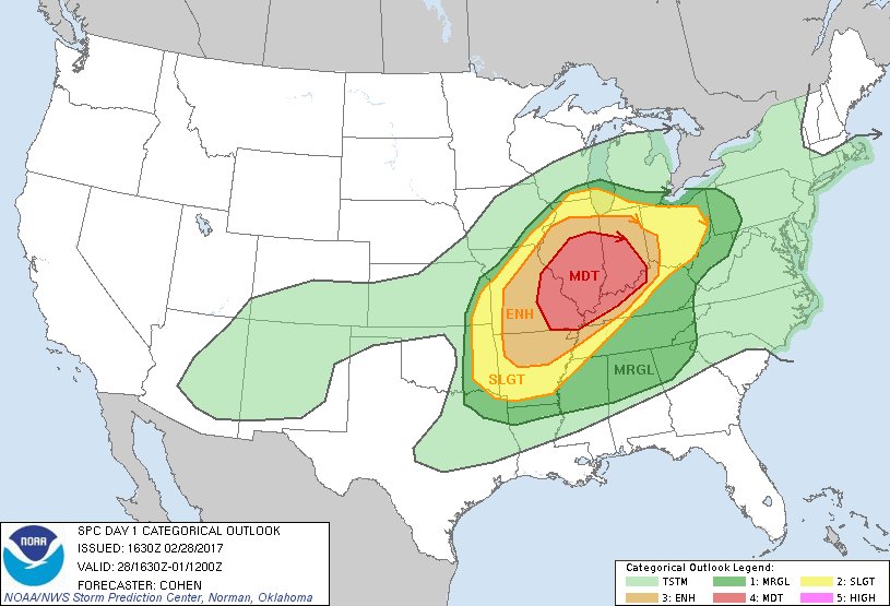
Day 1 Convective Outlook
NWS Storm Prediction Center Norman OK
1030 AM CST Tue Feb 28 2017
Valid 281630Z - 011200Z
...THERE IS A MODERATE RISK OF SEVERE THUNDERSTORMS ACROSS PORTIONS
OF EASTERN MO...CENTRAL/SOUTHERN IL...CENTRAL/SOUTHERN
INDIANA...WESTERN/NORTHERN KY
...THERE IS AN ENHANCED RISK OF SEVERE THUNDERSTORMS SURROUNDING THE
MODERATE RISK AREA ACROSS PORTIONS OF THE MO OZARKS TO THE
LOWER/MIDDLE OHIO VALLEY REGION...
...THERE IS A SLIGHT RISK OF SEVERE THUNDERSTORMS SURROUNDING THE
ENHANCED AREA FROM EASTERN OKLAHOMA AND ARKANSAS TOWARD THE LOWER
GREAT LAKES REGION...
...THERE IS A MARGINAL RISK OF SEVERE THUNDERSTORMS SURROUNDING THE
SLIGHT ACROSS PARTS OF THE CENTRAL AND EASTERN STATES...
...SUMMARY...
Severe thunderstorms are expected to develop from portions of the
lower Mississippi Valley to the Ohio Valley through tonight. Strong
tornadoes will be possible, especially across portions of the lower
and middle Ohio Valley. Otherwise, large hail and damaging winds are
expected.
...Portions of the MO Ozarks through the middle MS Valley and the
Ohio Valley region...
A prominent warm sector will continue to build
northward/northeastward across the region through tonight, as a
midlevel speed maximum advances from the southern Rockies
east-northeastward toward the Ohio Valley region. As lower/middle
60s dewpoints also develop northward/northeastward, an expansive
area of MLCAPE around 500-2000 J/kg -- aided by steep midlevel lapse
rates surmounting returning moisture -- will support vigorous
convective development. With warm-sector-coinciding effective shear
around 40-70 kt, a widespread area of conditional significant-severe
potential will exist -- especially from late afternoon into the
overnight hours. Present indications are that clusters of storms
will be evolving from eastern parts of the central/southern Great
Plains northeastward to the vicinity of southern Lake Michigan by
late afternoon/early evening in the vicinity of a baroclinic band --
with this activity spreading eastward into tonight. Confidence has
increased in more widespread severe-hail potential with this
activity, including significant severe hail. Open-warm-sector
convection will likely evolve along a low-level jet through parts of
the Ohio Valley tonight as additional moistening occurs. Effective
SRH of 300-400 m2/s2 will support tornado potential with evolving
supercell clusters. This includes the potential for nocturnal
significant tornadoes, and tornado probabilities have been
increased.
...Portions of the Southeast...
Destabilization along the southern/eastern flanks of convection over
the TN Valley region may support some increase in convective
intensity with storm clusters advancing toward the southern
Appalachians. Locally damaging wind gusts may accompany this
activity.
..Cohen.. 02/28/2017[/b]
Re: Potential Severe Weather Event; 2/28, 3/1; Mid South
Posted: Tue Feb 28, 2017 1:00 pm
by EF-5bigj
Well you don't wanna here that "Nocturnal significant tornadoes"
