Page 6 of 9

Re: Severe Weather event East Texas / LA / Miss / Ark - April 2 -3 - HIGH Risk - Far East Texas / N LA

Posted: Sun Apr 02, 2017 12:37 pm
by EF-5bigj
Monday just went moderate risk. :eek:

Re: Severe Weather event East Texas / LA / Miss / Ark - April 2 -3 - HIGH Risk - Far East Texas / N LA

Posted: Sun Apr 02, 2017 12:55 pm
by cycloneye
@spann
"Moderate risk" of severe storms now up for South Alabama tomorrow.

Image

Re: Severe Weather event East Texas / LA / Miss / Ala - April 2 -3 - HIGH Risk - Far East Texas / N LA

Posted: Sun Apr 02, 2017 12:58 pm
by TeamPlayersBlue
Sun is coming out a bit here in Sugar Land. Not good for convection.

Re: Severe Weather event East Texas / LA / Miss / Ark - April 2 -3 - HIGH Risk - Far East Texas / N LA

Posted: Sun Apr 02, 2017 1:02 pm
by Tireman4
Bunkertor wrote:BTW. The Shell Houston Open are in town


Yes it is Bunk. 5 miles from my house in Humble

Re: Severe Weather event East Texas / LA / Miss / Ala - April 2 -3 - HIGH Risk - Far East Texas / N LA

Posted: Sun Apr 02, 2017 1:03 pm
by cycloneye
Mesoscale Discussion 0403
NWS Storm Prediction Center Norman OK
1249 PM CDT Sun Apr 02 2017

Areas affected...Portions of eastern LA...central/western
MS...southern LA

Concerning...Severe potential...Watch possible

Valid 021749Z - 021945Z

Probability of Watch Issuance...40 percent

SUMMARY...The severe risk will gradually increase east of ongoing
Tornado Watch 109. While not presently likely, these areas will
continue to be monitored for possible watch issuance through
mid-afternoon. The severe risk and watch probabilities will increase
later in the afternoon.

DISCUSSION...Positive theta-e advection in association with a
northward-advancing warm front analyzed from west-central LA to
southern LA continues fostering convective development over
south-central LA. This activity is blossoming over the northern
extent of an uncapped, very moist boundary layer supporting
2000-3000 J/kg of MLCAPE. Lake Charles radar imagery indicates many
cells already exhibiting supercellular characteristics, and this
activity may continue developing northward across areas east of
Tornado Watch 109. Stronger deep ascent remains displaced to the
west of the area, and overall confidence in a more widespread severe
risk is limited in the short term. Nevertheless, with 35-50 kt of
effective shear supporting organized convective structures and
effective SRH of 300-500 m2/s2 building northward, the conditional
risk for severe hail, wind, and tornadoes may exist through
mid-afternoon. By later in the afternoon, as stronger deep ascent
arrives, unconditional severe-thunderstorm and tornado probabilities
will increase.

..Cohen/Hart.. 04/02/2017

Image

Re: Severe Weather event East Texas / LA / Miss / Ala - April 2 -3 - HIGH Risk - Far East Texas / N LA

Posted: Sun Apr 02, 2017 1:09 pm
by TeamPlayersBlue
According the the SPC mesoscale map, still LOTS of divergence over the SE Texas region, when the vorticity swings in, i think the storms will ramp up again. HRRR kind of says otherwise. I expect them to be a tad stronger or more widespread then its showing. Same situation happened on Monday. It had the tail end of the storms moving northeast with no growth behind them. Well, the tail grew. I expect them to continue to grow as it approaches SE Texas. I would continue to keep an eye out

Re: Severe Weather event East Texas / LA / Miss / Ala - April 2 -3 - HIGH Risk - Far East Texas / N LA

Posted: Sun Apr 02, 2017 1:18 pm
by cycloneye
@Unapproved Site
2 fatalities in Breaux Bridge, Louisiana following a possible tornado this morning (picture via St. Martin Parish Sheriff's Office)

Image

Re: Severe Weather event East Texas / LA / Miss / Ala - April 2 -3 - HIGH Risk - Far East Texas / N LA

Posted: Sun Apr 02, 2017 1:22 pm
by cycloneye
Very sad news:

BuzzFeedStorm Mother and child killed after possible tornado strikes Breaux Bridge, Louisiana, sheriff says

Re: Severe Weather event East Texas / Louisiana / Mississippi / Arkansas - April 2 -3 - Moderate Risk

Posted: Sun Apr 02, 2017 1:29 pm
by weatherdude1108
JDawg512 wrote:Tornado warning for northwestern Travis County, southwestern Williamson County. Hope Weatherdude is staying safe.


Hey there! We were actually down on Mopac and 183 (Steck) area at church when it hit. I texted my next door neighbor at time and she said a few small branches were down. The Wendy's down on Btaker and 183 has it's sign blown out.

I just got home. A few small branches are thrown down wind of neighbor's trees onto our property. Otherwise, Everything looks good here. Lots of wind and heavy rain. Those storms packed a punch! :eek:

Thankful for the rain! It is 68 degrees :)

Re: Severe Weather event East Texas / Louisiana / Mississippi / Arkansas - April 2 -3 - Moderate Risk

Posted: Sun Apr 02, 2017 1:32 pm
by weatherdude1108
weatherdude1108 wrote:
JDawg512 wrote:Tornado warning for northwestern Travis County, southwestern Williamson County. Hope Weatherdude is staying safe.


Hey there! We were actually down on Mopac and 183 (Steck) area at church when it hit. I texted my next door neighbor at time and she said a few small branches were down. The Wendy's down on Braker and 183 has its sign blown out.

I just got home. A few small branches are thrown down wind of neighbor's trees onto our property. Otherwise, Everything looks good here. Lots of wind and heavy rain. Those storms packed a punch! :eek:

Thankful for the rain! It is 68 degrees :)

Re: Severe Weather event East Texas / LA / Miss / Ala - April 2 -3 - HIGH Risk - Far East Texas / N LA

Posted: Sun Apr 02, 2017 1:35 pm
by RL3AO
PDS Tornado Watch issued until 9pm.

Image

Re: Severe Weather event East Texas / LA / Miss / Ala - April 2 -3 - HIGH Risk - Far East Texas / N LA

Posted: Sun Apr 02, 2017 1:41 pm
by PTrackerLA
Terrible news about the Breaux Bridge fatalities. We've had the sun come out off and on over the past hour and storms are explosively firing west of me near Lake Charles. Could have another round to deal with sooner than I expected :eek: .

Edit: RE TWC, just counted 6 active tornado warnings and numerous severe thunderstorm warnings, 2nd HIGH risk day of the year but they're showing "American Supernatural." I'm at a loss for words with this network.

Re: Severe Weather event East Texas / LA / Miss / Ala - April 2 -3 - HIGH Risk - Far East Texas / N LA

Posted: Sun Apr 02, 2017 1:44 pm
by RL3AO
Looks like mother nature turned the switch on in the last hour. Alexandria, LA may be in significant danger soon.

Re: Severe Weather event East Texas / LA / Miss / Ala - April 2 -3 - HIGH Risk - Far East Texas / N LA

Posted: Sun Apr 02, 2017 1:47 pm
by Bunkertor
129
WFUS54 KLCH 021841
TORLCH
LAC079-021915-
/O.NEW.KLCH.TO.W.0029.170402T1841Z-170402T1915Z/

BULLETIN - EAS ACTIVATION REQUESTED
TORNADO WARNING
NATIONAL WEATHER SERVICE LAKE CHARLES LA
141 PM CDT SUN APR 2 2017

THE NATIONAL WEATHER SERVICE IN LAKE CHARLES HAS ISSUED A

* TORNADO WARNING FOR...
SOUTH CENTRAL RAPIDES PARISH IN CENTRAL LOUISIANA...

* UNTIL 215 PM CDT

* AT 141 PM CDT, A CONFIRMED TORNADO WAS LOCATED NEAR GLENMORA,
MOVING NORTHEAST AT 25 MPH.


HAZARD...DAMAGING TORNADO AND QUARTER SIZE HAIL.

SOURCE...WEATHER SPOTTERS CONFIRMED TORNADO WEST OF GLENMORA AT
1:32 PM.

IMPACT...FLYING DEBRIS WILL BE DANGEROUS TO THOSE CAUGHT WITHOUT
SHELTER. MOBILE HOMES WILL BE DAMAGED OR DESTROYED.
DAMAGE TO ROOFS, WINDOWS, AND VEHICLES WILL OCCUR. TREE
DAMAGE IS LIKELY.

* THE TORNADO WILL BE NEAR...
LECOMPTE AROUND 155 PM CDT.

OTHER LOCATIONS IMPACTED BY THIS TORNADIC THUNDERSTORM INCLUDE
WOODWORTH, FOREST HILL AND MCNARY.

Re: Severe Weather event East Texas / LA / Miss / Ala - April 2 -3 - HIGH Risk - Far East Texas / N LA

Posted: Sun Apr 02, 2017 1:47 pm
by cycloneye
Wow! Heading to Alexandria LA.

Image

Re: Severe Weather event East Texas / Louisiana / Mississippi / Arkansas - April 2 -3 - Moderate Risk

Posted: Sun Apr 02, 2017 1:50 pm
by JDawg512
weatherdude1108 wrote:
JDawg512 wrote:Tornado warning for northwestern Travis County, southwestern Williamson County. Hope Weatherdude is staying safe.


Hey there! We were actually down on Mopac and 183 (Steck) area at church when it hit. I texted my next door neighbor at time and she said a few small branches were down. The Wendy's down on Braker and 183 has its sign blown out.

I just got home. A few small branches are thrown down wind of neighbor's trees onto our property. Otherwise, Everything looks good here. Lots of wind and heavy rain. Those storms packed a punch! :eek:

Thankful for the rain! It is 68 degrees :)


Yea luckily the storm wasn't too severe. Had some wind but nothing to write home about. The storm we had in February had stronger and more erratic winds. The main highlights with this one were lightning and torrential rain. Was lucky enough to get an inch and a half.

Gorgeous cool afternoon. 66 here at my house and enjoying the day with the house windows open. Looks like some wrap around clouds are coming in. I take it the temps will either hold steady or actually drop a few degrees. Going to be a great night! We better enjoy the cool weather while it lasts cause it will be long gone before we know it.

I'll feel even better once Shreveport is in the clear. I've been sending my sister updates and giving her heads up. They are currently under a severe storm warning.

Re: Severe Weather event East Texas / LA / Miss / Ala - April 2 -3 - HIGH Risk - Far East Texas / N LA

Posted: Sun Apr 02, 2017 1:50 pm
by cycloneye
@ReedTimmer
CONFIRMED TORNADO near Glenmora, LA at 141 pm CDT in Rapides Parish heading in direction of Alexandria. Be ready to take shelter Alexandria

Re: Severe Weather event East Texas / LA / Miss / Ala - April 2 -3 - HIGH Risk - Far East Texas / N LA

Posted: Sun Apr 02, 2017 1:52 pm
by JDawg512
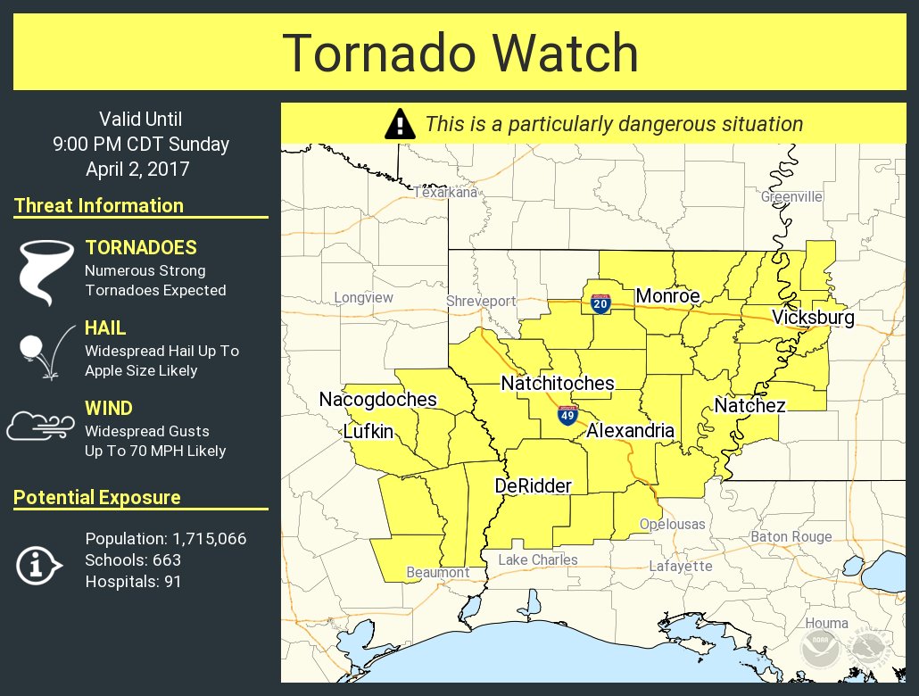
cycloneye wrote:Wow! Heading to Alexandria LA.

Image


:eek: Not good at all, please let it dissipate...

Re: Severe Weather event East Texas / LA / Miss / Ala - April 2 -3 - HIGH Risk - Far East Texas / N LA

Posted: Sun Apr 02, 2017 1:55 pm
by RL3AO
Considerable tag added.


Severe Weather Statement
National Weather Service Lake Charles LA
153 PM CDT SUN APR 2 2017

LAC079-021915-
/O.CON.KLCH.TO.W.0029.000000T0000Z-170402T1915Z/
Rapides LA-
153 PM CDT SUN APR 2 2017

...A TORNADO WARNING REMAINS IN EFFECT UNTIL 215 PM CDT FOR CENTRAL
RAPIDES PARISH...

At 153 PM CDT, a confirmed large and extremely dangerous tornado was
located 8 miles west of Lecompte, or 11 miles north of Glenmora,
moving northeast at 25 mph.

This is a PARTICULARLY DANGEROUS SITUATION. TAKE COVER NOW!

Re: Severe Weather event East Texas / LA / Miss / Ala - April 2 -3 - HIGH Risk - Far East Texas / N LA

Posted: Sun Apr 02, 2017 1:56 pm
by EF-5bigj
:eek: prayers I hope they get to shelter