Page 1 of 90
Texas Summer 2017
Posted: Wed May 31, 2017 6:06 pm
by gpsnowman
Well I will go ahead and do it. Breaking News Flash!! Summer will be hot hot hot. Just a matter of how hot. June could start off a little wet in the DFW area with small rain chances for a few days before rain chances drop to around 0%. Everyone stay cool and be careful in the summer heat.

Re: Texas Summer 2017
Posted: Wed May 31, 2017 6:18 pm
by Brent
Ew. My least favorite season by a mile. Wake me when it's over.

Re: Texas Summer 2017
Posted: Wed May 31, 2017 6:25 pm
by gboudx
Re: Texas Summer 2017
Posted: Wed May 31, 2017 7:42 pm
by Kalrany
It's already too hot!
How bad will it be? Anyone have any guesses? I am already certain of at least a baseline brutal...
Re: Texas Summer 2017
Posted: Wed May 31, 2017 10:37 pm
by bubba hotep
I like the way it might start
Re: Texas Summer 2017
Posted: Wed May 31, 2017 11:23 pm
by Brent
GFS sure has a lot of rain around through the first week of June. It also abandoned the heat wave Sunday/Monday for basically seasonal temps.
DFW only needs like .71" to get more than May
We can do it.
Re: Texas Summer 2017
Posted: Thu Jun 01, 2017 12:37 am
by South Texas Storms
Brent wrote:GFS sure has a lot of rain around through the first week of June. It also abandoned the heat wave Sunday/Monday for basically seasonal temps.
DFW only needs like .71" to get more than May
We can do it.
Yep it doesn't look like a bad start to meteorological summer across Texas over the next several days. Daily rain chances along with cooler than normal temperatures. Sign me up for this all summer please!

Re: Texas Summer 2017
Posted: Thu Jun 01, 2017 8:15 am
by Ntxw
Ahh another Texas summer. One of the most feared season in these parts with high AC bills, hot cars, smog, and dead lawns, may we dream of 1906, 1973. Or even 2002, 2004, 2007 will do.
Re: Texas Summer 2017
Posted: Thu Jun 01, 2017 8:34 am
by srainhoutx
Thursday morning briefing from Jeff:
Active weather pattern will remain in place over the next several days.
Short wave overnight that produce a couple of rounds of showers and thunderstorms is progressing east of the region with rainfall generally ending over the area as slightly drier air sweeps northward from the Gulf of Mexico. Main question is do we see any re development of showers and thunderstorms with heating this afternoon. Weak subsidence behind the short wave will be in place through much of the morning hours, but as temperatures rise into the upper 70’s to lower 80’s expect a few showers and thunderstorms to develop. Should we get more heating than expected thunderstorms could become more numerous.
Expect overall less coverage of showers and thunderstorms on Friday and possibly Saturday with rain chances in the 30-40% range.
New surge of tropical moisture will arrive into the TX coast late Saturday into Sunday as northern fringe of current TD-2E in the eastern Pacific spreads northward across the western Gulf and into TX. Additionally another upper level trough will be approaching from the west at this time yielding lift across the moistening air mass. Not seeing any surface boundary to help focus heavy thunderstorms, but will have to keep an eye on any outflow boundaries that may be lingering over the region. The upper trough is looking slower and slower in model guidance which will keep rain chances going now well into next week.
Main threat over the next several days will continue to be locally heavy rainfall with PWS hovering around 1.8-2.0 inches and at times slow storm motions which could yield a quick 1-2 inches of rain.
Gulf of Mexico:
Today marks the start of the 2017 Atlantic basin hurricane season. Current season predictors including the forecasted state of El Nino, sea surface temperatures across the Atlantic, and forecasted moisture and sea level pressures this summer over the basin suggest a near normal to above average number of named storms for 2017. Most of these indicators have been trending more favorable for an active hurricane season over the last two months.
Tropical depression 2E currently over the eastern Pacific Ocean just south of the Mexican coast is moving NE this morning and will make landfall along the coast later today. Mid and high level moisture from this system is already expanding NNE across the southern Gulf of Mexico and some of this moisture will be brought northward toward the US Gulf coast over the weekend. Additionally, global forecast models show some sort of mid level circulation from TD 2E arriving into the southern Gulf of Mexico early this weekend and have off and on shown the formation of a surface reflection over the western Gulf by late this weekend. With an upper trough approaching TX by Sunday upper level winds across the NW/W Gulf should generally be unfavorable for development, but there is at least some potential for a weak sheared tropical system to attempt to form this weekend or early next week across the western Gulf of Mexico.
Re: Texas Summer 2017
Posted: Thu Jun 01, 2017 8:47 am
by Ntxw
We definitely have to watch the WGOM for a moisture surge with lower pressures. Not sure if a system (if any) will directly effect us but it's moisture plume may. A huge chunk is currently TD2 in the EPAC

Re: Texas Summer 2017
Posted: Thu Jun 01, 2017 9:47 am
by bubba hotep
Sun is breaking through out this way and the 12z FWD sounding showed some decent CAPE already in place. Shear is weak and lapse rates aren't overly impressive so storm mode should be messy hit and miss type stuff. The HRRR and 3k NAM are just kind of lurching around, maybe we get lucky with some slow moving downpours.
Re: Texas Summer 2017
Posted: Thu Jun 01, 2017 10:09 am
by CaptinCrunch
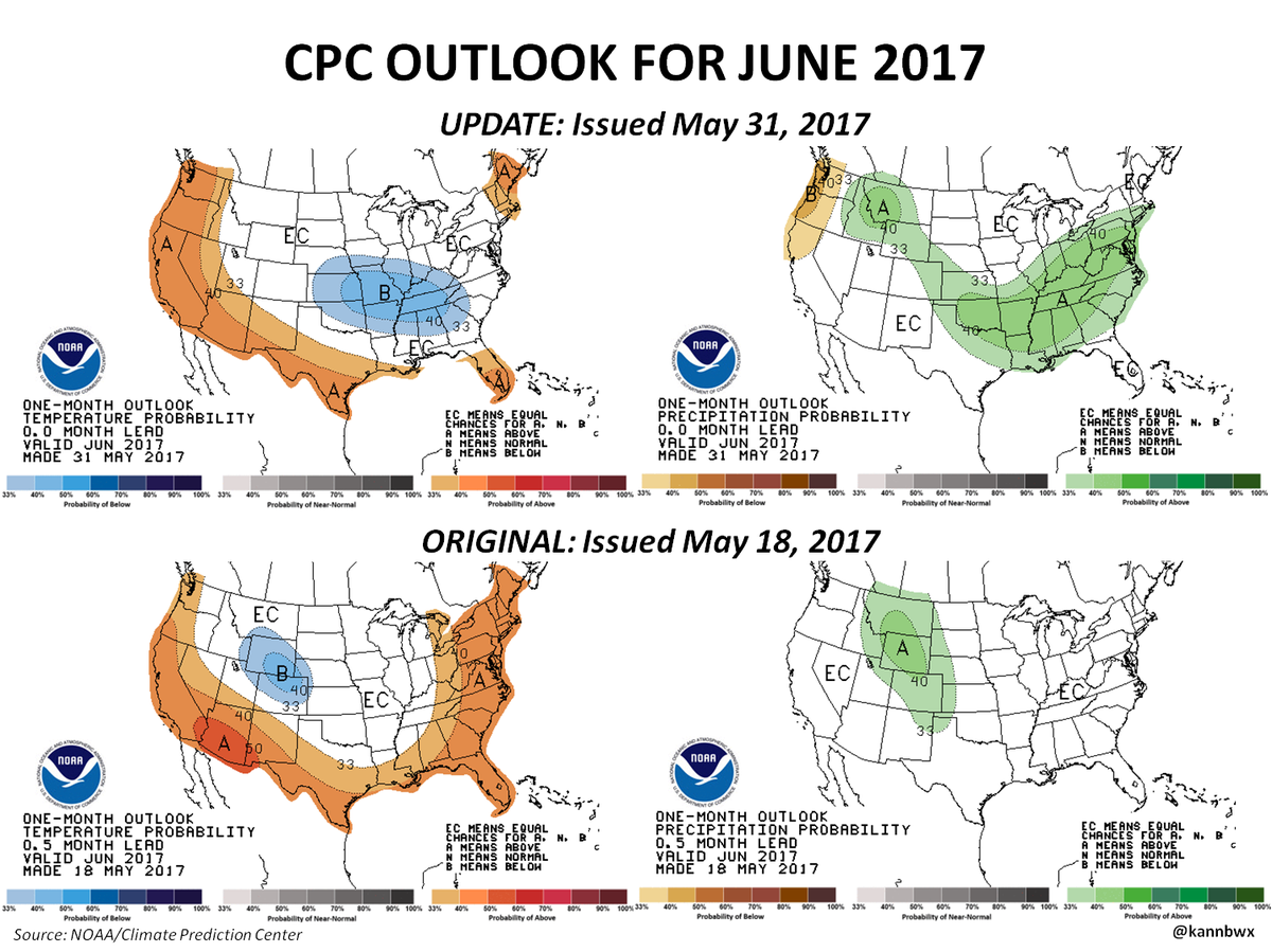
I don't believe any of the monthly outlooks, If I recall May was supposed to above average for precip, yet we just has our 4th driest May on record for NTX.

May 2017 was warmer and much drier than normal for Dallas/Fort Worth. The mean monthly temperature was 75.4 degrees which is 1.5 degrees above normal. The warmest May on record was in 1996 with a mean temperature of 79.7 degrees. The coolest May on record was in 1907 with a mean temperature of 66.1 degrees. May's rainfall total was only 0.70 inches which was 4.2 inches below normal. This was the 4th driest May on record. May is normally our wettest month with 4.9 inches of rain. The wettest May on record was 16.96 inches in 2015 and the driest May on record was 0.22 inches in
1911.

Re: Texas Summer 2017
Posted: Thu Jun 01, 2017 10:29 am
by CaptinCrunch
I fully believe our planet is growing a little warmer every year. Half of the top 10 warmest springs have been since 2006, with 3 of them in the last 6 years. 2016 had the warmest Fall on record, Winter was in the top 4 warmest, and now Spring 3rd warmest on record.
So either Global warming is much more evident or we are still feeling the effects of the Super El Nino 2014/2015

Re: Texas Summer 2017
Posted: Thu Jun 01, 2017 10:48 am
by TeamPlayersBlue
I dont exactly know how they are plotting temps for "global warming," but as far as local temps, urban heat island is a MAJOR factor and is skewing temps locally for metropolitan areas. I know areas are warming in rural areas as well, (Arctic), but temps rise three degrees every time i drive into Houston from the suburbs in Sugar Land. Even Sugar Land itself might have a beat of an urban heat island effect.
Re: Texas Summer 2017
Posted: Thu Jun 01, 2017 11:08 am
by Yukon Cornelius
Forecast slowly dropping rain chances over the next few days. Sigh
Re: Texas Summer 2017
Posted: Thu Jun 01, 2017 11:16 am
by bubba hotep
1st batch of storms is slowly lifting NW but missed most of DFW outside of Denton and northern Collin County. There appears to be a weak outflow boundary pushing in from the west. Maybe that can fire some additional storms later across DFW.
Re: Texas Summer 2017
Posted: Thu Jun 01, 2017 12:14 pm
by DonWrk
Finally getting hammered here thankfully!
Re: Texas Summer 2017
Posted: Thu Jun 01, 2017 1:07 pm
by JDawg512
May was just miserable for rainfall at my place, well below average. Even with the recent storms over Memorial day weekend, it still wasn't enough to do much. June really needs to step up or we will have a pretty ugly summer.
There's some scattered activity slowly moving up from the coast but at this time am pretty skeptical it will make it up here. Even if it does, it will probably be hit or miss.
Re: Texas Summer 2017
Posted: Thu Jun 01, 2017 1:22 pm
by weatherdude1108
Bob Rose talked about Summer and a review of this past Spring in Central Texas in his June 1st blog:
The Climate Prediction Center's latest summer outlook for Central Texas calls for temperatures to average warmer than normal and rainfall to average slightly above normal: Taking a look back at meteorological spring (March-May), temperatures across Central and South Texas averaged well above normal. Rainfall averaged slightly below normal across the Hill Country, near to slightly below normal across Central Texas and above normal across the middle Texas coast.
 Spring statistics:
In Austin, spring 2017 was the 5th warmest spring on record at Camp Mabry, with an average temperature of 72.2 degrees, 3.1 degrees above normal.
Spring rainfall at Camp Mabry totaled 6.56 inches. This was 2.73 inches below normal and ranked as the 30th driest spring on record.
At Austin-Bergstrom, the temperature this spring averaged 71.2 degrees, 4.0 degrees above normal. This ranked as the 9th warmest spring on record.
Spring rainfall at Austin-Bergstrom totaled 7.47 inches. This was 1.63 inches below normal and ranked as the 28th driest spring on record.
May statistics:
Looking at the month of May, temperatures averaged near to slightly below normal across the entire region. Rainfall averaged below normal across the Hill Country and Central Texas regions and near normal across the middle Texas coast.
In Austin, Camp Mabry recorded 2.86 inches of rain, which was 1.58 inches below normal. (May 2015 rain totaled 17.59 inches and May 2016 totaled 7.15 inches). This was the driest May since 2011, when only 1.88 inches was recorded. May 2017 ranked as the 38th driest May on record.
The May temperature at Camp Mabry averaged 76.3 degrees, 0.3 degrees below normal. May 2017 ranked as the 38th warmest, or the 78th coolest May on record.
At Austin-Bergstrom, May rainfall totaled 2.99 inches, 1.06 inches below normal. (May 2015 rain totaled 13.44 inches and May 2016 totaled 15.82 inches). This was the driest May since 2011, when only 1.91 inches was recorded). May 2017 ranked as the 26th driest on record.
The May temperature at Austin-Bergstrom averaged 75.5 degrees. 0.3 degrees above normal. May 2017 ranked as the 38th warmest, or the 34th coolest May on record.
Welcome to summer!
Bobhttp://www.lcra.org/water/river-and-wea ... ather.aspx
Re: Texas Summer 2017
Posted: Thu Jun 01, 2017 1:33 pm
by Brent
We have thunder!
and now rain