Texas Spring 2018
Moderator: S2k Moderators
Forum rules

The posts in this forum are NOT official forecast and should not be used as such. They are just the opinion of the poster and may or may not be backed by sound meteorological data. They are NOT endorsed by any professional institution or STORM2K.
-
Haris

- Category 5

- Posts: 1808
- Joined: Mon Nov 27, 2017 8:19 pm
- Location: ( Bee Cave) West Austin, Texas
Re: Texas Spring 2018
Picked up .59" in W Austin today! The rain lover is happy! Nearing .8" for the month. Still have a long ways to go
2 likes
Weather geek and a storm spotter in West Austin. Not a degreed meteorologist. Big snow fan. Love rain and cold! Despise heat!
-
weatherdude1108
- Category 5
- Posts: 4172
- Joined: Tue Dec 13, 2011 1:04 pm
- Location: Northwest Austin/Cedar Park, TX
Re: Texas Spring 2018
I got about 0.25 of an inch in my yard.
0 likes
The preceding post is NOT an official forecast, and should not be used as such. It is only the opinion of the poster and may or may not be backed by sound meteorological data. It is NOT endorsed by any professional institution including storm2k.org. For Official Information please refer to the NHC and NWS products.
-
South Texas Storms

- Professional-Met

- Posts: 4005
- Joined: Thu Jun 24, 2010 12:28 am
- Location: Houston, TX
Re: Texas Spring 2018
Nice surprise storm in SA today! My parent's house picked up almost 1.5 inches of rain...we're very thankful. 
Hoping for lots more next week!
Hoping for lots more next week!
4 likes
-
Haris
- Category 5
- Posts: 1808
- Joined: Mon Nov 27, 2017 8:19 pm
- Location: ( Bee Cave) West Austin, Texas
Re: Texas Spring 2018
South Texas Storms wrote:Nice surprise storm in SA today! My parent's house picked up almost 1.5 inches of rain...we're very thankful.
Hoping for lots more next week!
Gfs turned a lot drier . Hopefully a fluke but models backing off a bit . Hope not but it’s been a trend this year
0 likes
Weather geek and a storm spotter in West Austin. Not a degreed meteorologist. Big snow fan. Love rain and cold! Despise heat!

-
South Texas Storms
- Professional-Met
- Posts: 4005
- Joined: Thu Jun 24, 2010 12:28 am
- Location: Houston, TX
Re: Texas Spring 2018
Haris wrote:South Texas Storms wrote:Nice surprise storm in SA today! My parent's house picked up almost 1.5 inches of rain...we're very thankful.
Hoping for lots more next week!
Gfs turned a lot drier . Hopefully a fluke but models backing off a bit . Hope not but it’s been a trend this year
0z GFS Ensemble is still pretty wet. Think much of TX has a good chance of seeing some heavy rain next week.
0 likes
-
weatherdude1108
- Category 5
- Posts: 4172
- Joined: Tue Dec 13, 2011 1:04 pm
- Location: Northwest Austin/Cedar Park, TX
Re: Texas Spring 2018
Looks like the southern and central part of the EWX region (southern Austin and SA) got the feast of this event yesterday. While those in the northern and eastern part (north Austin north and eastward) got the famine. To be expected based on what was forecasted, but still kind of bummed. Congrats to those who got a half inch or more! 

Looks like the chance comes back starting next Monday. Thank you Pacific tap!
Looks like the chance comes back starting next Monday. Thank you Pacific tap!
1 likes
The preceding post is NOT an official forecast, and should not be used as such. It is only the opinion of the poster and may or may not be backed by sound meteorological data. It is NOT endorsed by any professional institution including storm2k.org. For Official Information please refer to the NHC and NWS products.
-
bubba hotep

- S2K Supporter

- Posts: 5456
- Joined: Wed Dec 28, 2016 1:00 am
- Location: Collin County Texas
Re: Texas Spring 2018
The models are trending away from a stout SW cutoff kicking out to that energy getting sheared out into the base of a large positive tilted GL trough. Models were faster and shallower with the northern stream earlier in the weak. The slower deeper look allows it to muck up our southern stream cutoff. That would probably mean another round of cooler air to start May but it also reduces the chances of a widespread multi round rain event for Texas. Maybe things trend back the other way over the next week.
0 likes
Winter time post are almost exclusively focused on the DFW area.
-
Haris
- Category 5
- Posts: 1808
- Joined: Mon Nov 27, 2017 8:19 pm
- Location: ( Bee Cave) West Austin, Texas
Re: Texas Spring 2018
bubba hotep wrote:The models are trending away from a stout SW cutoff kicking out to that energy getting sheared out into the base of a large positive tilted GL trough. Models were faster and shallower with the northern stream earlier in the weak. The slower deeper look allows it to muck up our southern stream cutoff. That would probably mean another round of cooler air to start May but it also reduces the chances of a widespread multi round rain event for Texas. Maybe things trend back the other way over the next week.
That’s just plain cruel! I get excited and then they turn away like that . Hopefully they go back! But it’s been over a month since our last inch rain fall and May is the wettest month for us
0 likes
Weather geek and a storm spotter in West Austin. Not a degreed meteorologist. Big snow fan. Love rain and cold! Despise heat!
-
weatherdude1108
- Category 5
- Posts: 4172
- Joined: Tue Dec 13, 2011 1:04 pm
- Location: Northwest Austin/Cedar Park, TX
Re: Texas Spring 2018
Haris wrote:bubba hotep wrote:The models are trending away from a stout SW cutoff kicking out to that energy getting sheared out into the base of a large positive tilted GL trough. Models were faster and shallower with the northern stream earlier in the weak. The slower deeper look allows it to muck up our southern stream cutoff. That would probably mean another round of cooler air to start May but it also reduces the chances of a widespread multi round rain event for Texas. Maybe things trend back the other way over the next week.
That’s just plain cruel! I get excited and then they turn away like that . Hopefully they go back! But it’s been over a month since our last inch rain fall and May is the wettest month for us. But aren’t the conditions favorable for significant rains here in TX ? The SOI and Wwb?
Model flippity flop?

0 likes
The preceding post is NOT an official forecast, and should not be used as such. It is only the opinion of the poster and may or may not be backed by sound meteorological data. It is NOT endorsed by any professional institution including storm2k.org. For Official Information please refer to the NHC and NWS products.
-
Haris
- Category 5
- Posts: 1808
- Joined: Mon Nov 27, 2017 8:19 pm
- Location: ( Bee Cave) West Austin, Texas
Re: Texas Spring 2018
bubba hotep wrote:The models are trending away from a stout SW cutoff kicking out to that energy getting sheared out into the base of a large positive tilted GL trough. Models were faster and shallower with the northern stream earlier in the weak. The slower deeper look allows it to muck up our southern stream cutoff. That would probably mean another round of cooler air to start May but it also reduces the chances of a widespread multi round rain event for Texas. Maybe things trend back the other way over the next week.

Now what’s weird. GEFS
0 likes
Weather geek and a storm spotter in West Austin. Not a degreed meteorologist. Big snow fan. Love rain and cold! Despise heat!
-
weatherdude1108
- Category 5
- Posts: 4172
- Joined: Tue Dec 13, 2011 1:04 pm
- Location: Northwest Austin/Cedar Park, TX
Re: Texas Spring 2018
Haris wrote:bubba hotep wrote:The models are trending away from a stout SW cutoff kicking out to that energy getting sheared out into the base of a large positive tilted GL trough. Models were faster and shallower with the northern stream earlier in the weak. The slower deeper look allows it to muck up our southern stream cutoff. That would probably mean another round of cooler air to start May but it also reduces the chances of a widespread multi round rain event for Texas. Maybe things trend back the other way over the next week.
http://i63.tinypic.com/2gxoj5s.png
Now what’s weird. GEFS
I got this.

1 likes
The preceding post is NOT an official forecast, and should not be used as such. It is only the opinion of the poster and may or may not be backed by sound meteorological data. It is NOT endorsed by any professional institution including storm2k.org. For Official Information please refer to the NHC and NWS products.
-
Brent
- S2K Supporter
- Posts: 37089
- Age: 35
- Joined: Sun May 16, 2004 10:30 pm
- Location: Tulsa Oklahoma
- Contact:
Re: Texas Spring 2018
Euro has a flooding event for DFW(5 inches+) end of next week Austin near 2 inches
0 likes
#neversummer
-
bubba hotep
- S2K Supporter
- Posts: 5456
- Joined: Wed Dec 28, 2016 1:00 am
- Location: Collin County Texas
Re: Texas Spring 2018
Brent wrote:Euro has a flooding event for DFW(5 inches+) end of next week Austin near 2 inches
Euro is a lot less progressive than the past few runs and drops nearly 10" in some of the NE areas.
1 likes
Winter time post are almost exclusively focused on the DFW area.
Re: Texas Spring 2018
bubba hotep wrote:Brent wrote:Euro has a flooding event for DFW(5 inches+) end of next week Austin near 2 inches
Euro is a lot less progressive than the past few runs and drops nearly 10" in some of the NE areas.
Another big event for NE TX lol what a surprise.
1 likes
-
weatherdude1108
- Category 5
- Posts: 4172
- Joined: Tue Dec 13, 2011 1:04 pm
- Location: Northwest Austin/Cedar Park, TX
Re: Texas Spring 2018
Cpv17 wrote:bubba hotep wrote:Brent wrote:Euro has a flooding event for DFW(5 inches+) end of next week Austin near 2 inches
Euro is a lot less progressive than the past few runs and drops nearly 10" in some of the NE areas.
Another big event for NE TX lol what a surprise.
2 inches would be nice. 3-5 inches would be icing.
1 likes
The preceding post is NOT an official forecast, and should not be used as such. It is only the opinion of the poster and may or may not be backed by sound meteorological data. It is NOT endorsed by any professional institution including storm2k.org. For Official Information please refer to the NHC and NWS products.
-
weatherdude1108
- Category 5
- Posts: 4172
- Joined: Tue Dec 13, 2011 1:04 pm
- Location: Northwest Austin/Cedar Park, TX
Re: Texas Spring 2018
Temps and precip probabilities look nice for early May.


2 likes
The preceding post is NOT an official forecast, and should not be used as such. It is only the opinion of the poster and may or may not be backed by sound meteorological data. It is NOT endorsed by any professional institution including storm2k.org. For Official Information please refer to the NHC and NWS products.
-
weatherdude1108
- Category 5
- Posts: 4172
- Joined: Tue Dec 13, 2011 1:04 pm
- Location: Northwest Austin/Cedar Park, TX
Re: Texas Spring 2018
Several people here at work have commented how nice it is out there. One even asked "Why are we inside?"
If I could, I would move my desk out there. It seriously is Chamber O' Commerce out there right now.

If I could, I would move my desk out there. It seriously is Chamber O' Commerce out there right now.
0 likes
The preceding post is NOT an official forecast, and should not be used as such. It is only the opinion of the poster and may or may not be backed by sound meteorological data. It is NOT endorsed by any professional institution including storm2k.org. For Official Information please refer to the NHC and NWS products.
-
aggiecutter
- Category 5
- Posts: 1743
- Joined: Thu Oct 14, 2004 9:22 pm
- Location: Texarkana
Re: Texas Spring 2018
Cpv17 wrote:bubba hotep wrote:Brent wrote:Euro has a flooding event for DFW(5 inches+) end of next week Austin near 2 inches
Euro is a lot less progressive than the past few runs and drops nearly 10" in some of the NE areas.
Another big event for NE TX lol what a surprise.
That has been pattern since last summer.
0 likes
-
bubba hotep
- S2K Supporter
- Posts: 5456
- Joined: Wed Dec 28, 2016 1:00 am
- Location: Collin County Texas
Re: Texas Spring 2018
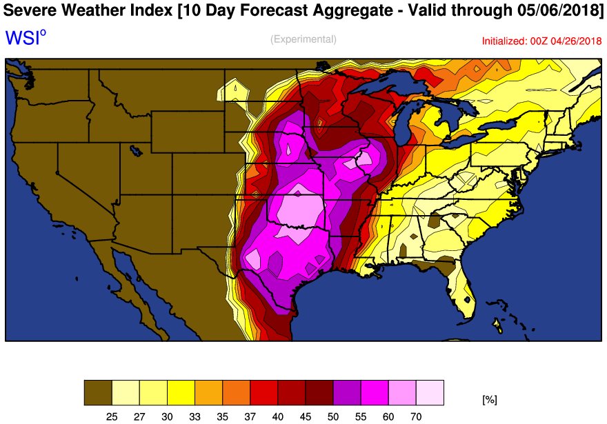
Some of the svr wx nerds out there have been starting to hype this upcoming period. Outside of the larger scale pattern, it seems pointless to discuss shear profiles, CAPE values, etc until much closer to the event but Mike V posted this:
2 likes
Winter time post are almost exclusively focused on the DFW area.
Return to “USA & Caribbean Weather”
Who is online
Users browsing this forum: MetroMike and 67 guests