Page 11 of 69
Re: Texas Spring 2018
Posted: Sat Mar 17, 2018 4:10 pm
by rwfromkansas
Yeah I am right there. Going back up now btw.
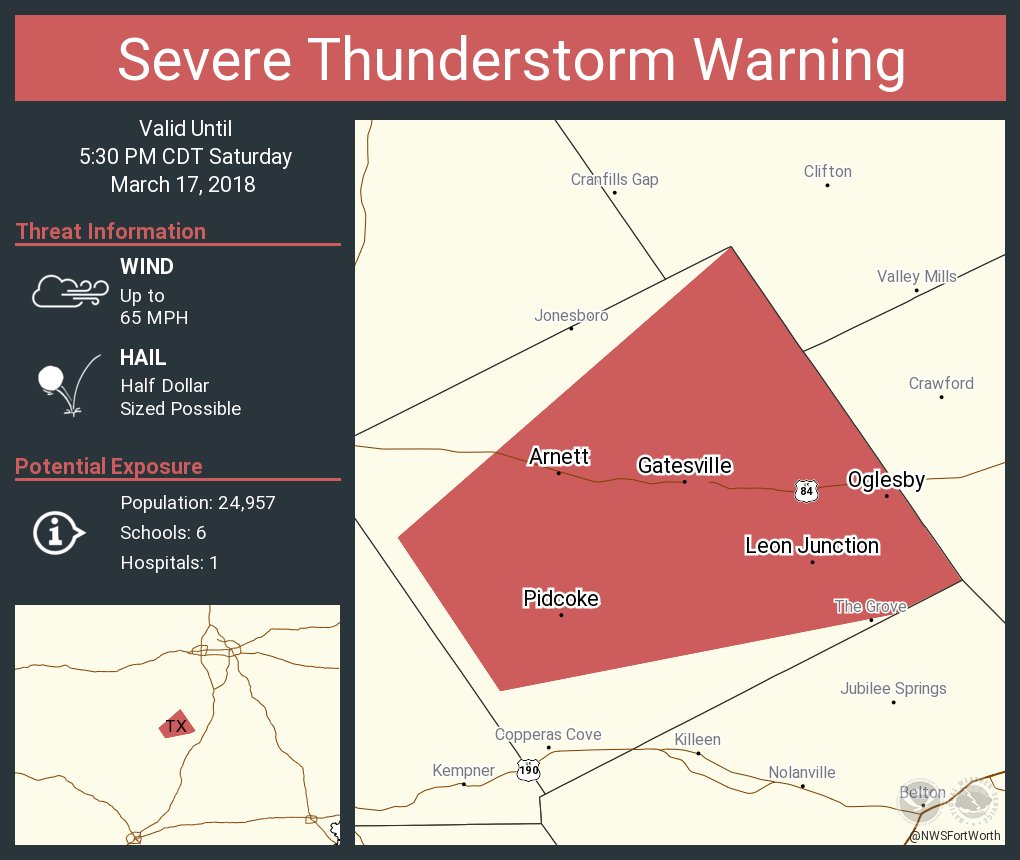
Re: Texas Spring 2018
Posted: Sat Mar 17, 2018 4:26 pm
by bubba hotep
Re: Texas Spring 2018
Posted: Sat Mar 17, 2018 6:07 pm
by 1900hurricane
If that sucker wasn't hanging out just behind the outflow boundary, I'd already be most of the way there probably.
Re: Texas Spring 2018
Posted: Sat Mar 17, 2018 7:46 pm
by bubba hotep
No storms here, just ended up with some steady rain.
Re: Texas Spring 2018
Posted: Sat Mar 17, 2018 8:01 pm
by bubba hotep
It looks like the airport picked up 1/4" of rain but might pick up some more with some new storms firing.

Re: Texas Spring 2018
Posted: Sat Mar 17, 2018 9:03 pm
by weatherdude1108
I picked up almost a half inch of rain from a cell that came through around 7:30pm. Very nice!

Re: Texas Spring 2018
Posted: Sat Mar 17, 2018 10:54 pm
by rwfromkansas
No severe but a half-inch here.
Re: Texas Spring 2018
Posted: Sat Mar 17, 2018 11:54 pm
by Brent
nice soaking rain and no severe weather... can't beat that
5% tornado centered on the metroplex again for tomorrow... looks like the focus will be more north than today
An increase in low-level hodograph curvature by
late afternoon to the evening suggests a tornado threat will be
possible as storms that form in North TX
Re: Texas Spring 2018
Posted: Sun Mar 18, 2018 3:13 am
by bubba hotep
Re: Texas Spring 2018
Posted: Sun Mar 18, 2018 8:57 am
by bubba hotep
Tornado

That is an ugly Hail hatched area, no thanks!

Re: Texas Spring 2018
Posted: Sun Mar 18, 2018 9:03 am
by Ntxw
Looks about the same risk as yesterday only centered in northeast areas.
DFW picked up a little more than half inch so far.
Re: Texas Spring 2018
Posted: Sun Mar 18, 2018 10:26 am
by Haris
Ntxw wrote:Looks about the same risk as yesterday only centered in northeast areas.
DFW picked up a little more than half inch so far.
How do the prospects of wet weather look? I am seeing a clear wet signal ? How about you guys ?
Re: Texas Spring 2018
Posted: Sun Mar 18, 2018 10:48 am
by Brent
Hi-res models appear to have some possible supercells around DFW late this afternoon and early evening
Re: Texas Spring 2018
Posted: Sun Mar 18, 2018 10:53 am
by bubba hotep
Brent wrote:Hi-res models appear to have some possible supercells around DFW late this afternoon and early evening
HRRR appears to track a couple of cells across the area but the 12z 3k NAM shows basically nothing.
Re: Texas Spring 2018
Posted: Sun Mar 18, 2018 11:58 am
by 1900hurricane
SPC picked a weird day to be ~30 minutes late with the Convective Outlook.
Re: Texas Spring 2018
Posted: Sun Mar 18, 2018 12:09 pm
by Brent
SPC update:
But given some hindered heating through early afternoon and the
early timing of the aforementioned southern-stream impulse, the
likelihood and extent of deep convective development later today
remains questionable, particularly given that areas such as
north-central Texas may be influenced by subsidence aloft during
peak heating. Accordingly, the overall scenario seemingly remains
largely conditional, with the notion that any sustained
surface-rooted development could evolve into supercells capable of
very large hail and some tornado risk in the presence of steep
mid-level lapse rates, moderate buoyancy, and favorable hodographs
for large diameter (potentially significant 2+ inch) hail.
Re: Texas Spring 2018
Posted: Sun Mar 18, 2018 12:38 pm
by bubba hotep
HRRR has been very consistent this morning showing multiple cells tracking across N. Texas. However, I'm not seeing much support for this scenario from the other CAMs.

Re: Texas Spring 2018
Posted: Sun Mar 18, 2018 12:57 pm
by bubba hotep
12z Texas Tech is also a no go for storms across N. Texas today. As far as large scale, the Euro doesn't really produce anything across N. Texas. It looks like this will most likely just be a muggy afternoon for the area.
ETA: Clouds are starting to thin across N. Texas and the dryline is still well to our west. Might not be out of the woods after all, it looks like the potential is there for some very nasty hail with any cells that do fire.
Re: Texas Spring 2018
Posted: Sun Mar 18, 2018 1:31 pm
by cheezyWXguy
bubba hotep wrote:12z Texas Tech is also a no go for storms across N. Texas today. As far as large scale, the Euro doesn't really produce anything across N. Texas. It looks like this will most likely just be a muggy afternoon for the area.
ETA: Clouds are starting to thin across N. Texas and the dryline is still well to our west. Might not be out of the woods after all, it looks like the potential is there for some very nasty hail with any cells that do fire.
The HRRR and RGEM are showing the storms, but without the support of the NAM and now the WRF suite as well (storms depicted on 0z, but not 12z), chances seem less than 50-50 that this event will play out. Really seems like an all-or-none type of event today.
Re: Texas Spring 2018
Posted: Sun Mar 18, 2018 1:45 pm
by bubba hotep
cheezyWXguy wrote:bubba hotep wrote:12z Texas Tech is also a no go for storms across N. Texas today. As far as large scale, the Euro doesn't really produce anything across N. Texas. It looks like this will most likely just be a muggy afternoon for the area.
ETA: Clouds are starting to thin across N. Texas and the dryline is still well to our west. Might not be out of the woods after all, it looks like the potential is there for some very nasty hail with any cells that do fire.
The HRRR and RGEM are showing the storms, but without the support of the NAM and now the WRF suite as well (storms depicted on 0z, but not 12z), chances seem less than 50-50 that this event will play out. Really seems like an all-or-none type of event today.
The NCAR ensembles really helped with days like this over the last couple of years but they stopped running them.