Texas Summer 2018

U.S. & Caribbean Weather Discussions and Severe Weather Events

Moderator: S2k Moderators

Forum rules

The posts in this forum are NOT official forecast and should not be used as such. They are just the opinion of the poster and may or may not be backed by sound meteorological data. They are NOT endorsed by any professional institution or STORM2K.

Help Support Storm2K
Message
Author
weatherdude1108
Category 5
Category 5
Posts: 4172
Joined: Tue Dec 13, 2011 1:04 pm
Location: Northwest Austin/Cedar Park, TX

Re: Texas Summer 2018

#241 Postby weatherdude1108 » Thu Jun 14, 2018 2:41 pm

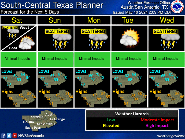
Cpv17 wrote:CPC now has a 4 day stretch for potentially heavy rainfall across much of the state.
Image


I will miss out on this. Bummer. I'll be in Michigan all next week. But I can check it remotely from my outdoor camera. :wink:
0 likes   
The preceding post is NOT an official forecast, and should not be used as such. It is only the opinion of the poster and may or may not be backed by sound meteorological data. It is NOT endorsed by any professional institution including storm2k.org. For Official Information please refer to the NHC and NWS products.

weatherdude1108
Category 5
Category 5
Posts: 4172
Joined: Tue Dec 13, 2011 1:04 pm
Location: Northwest Austin/Cedar Park, TX

Re: Texas Summer 2018

#242 Postby weatherdude1108 » Thu Jun 14, 2018 3:38 pm

Interesting model developments, mainly with the ECWMF.

Area Forecast Discussion
National Weather Service Austin/San Antonio TX
258 PM CDT Thu Jun 14 2018

.SHORT TERM (Tonight through Friday Night)...
Similar to yesterday, isolated to scattered showers and thunderstorms
were developing mostly east of the I-35 corridor and south of the
I-10 corridor east of San Antonio. These storms were moving northwest
at about 25 mph and producing occasional lightning. Also similar to
yesterday, 20+ degree dewpoint depressions and a slight inverted V
sounding situation in the lowest 150 mb could result in some gusty
winds of over 40 mph as these cells collapse. We did see some minor
wind damage due to a microburst yesterday near San Antonio, and that
chance exists again today due to very similar conditions.
TTU-WRF and
HRRR outcomes show the majority, if not all of this coverage
diminishing by 00Z.

Another day of very similar conditions is expected tomorrow with late
morning to early afternoon CI, isolated to scattered showers and
thunderstorms, and the potential for gusty winds and some brief
heavy rain.

&&

.LONG TERM (Saturday through Thursday)...
The bulk of the very moist tropical air mass will begin arriving in
the eastern CWA Sunday which will begin the multi-day chances for
precip.
While the overall forecast details have not changed
substantially, some model changes have been noted that stand out.

For instance, the 12Z ECMWF deterministic model is producing
significantly more QPF than in previous runs, with upwards of 12
inches possible over both the Rio Grande Plains and Coastal Plains.
This is obviously a considerable increase in QPF generation through
the upcoming week. This is largely due to its depiction of stalling
the parent upper low over the CWA and bringing round after round of
slow moving areas of heavy rainfall. However, the validity of this
outcome is highly in question, mostly due to the fact that both the
GFS and Canadian are only producing about a quarter of the QPF thus
making it inconsistent with other model depictions. Also, the ECMWF
doesn`t even agree with itself, as a standard deviation in PoP
potential is 14+ when comparing the individual ECMWF ensemble
members. This is likely due to disagreement in individual members on
resolving coherent lifting mechanisms.
Thus, with better model
consistency in the MEN/GFS and further confidence in the lower values
with the Canadian being in fairly close agreement, opted to keep the
forecast QPF at what was advertised with the previous forecast.

However, if the ECMWF overall synoptic set up turns out to be
correct, at the very least, the possibility for PoPs may linger
further into the week. Possibly as long as Friday. If this indeed
does occur, isolated amounts may be need to be adjusted higher than
the 5-7 inches currently advertised.
More detail will be available
as this event begins to enter the short term model domain.
0 likes   
The preceding post is NOT an official forecast, and should not be used as such. It is only the opinion of the poster and may or may not be backed by sound meteorological data. It is NOT endorsed by any professional institution including storm2k.org. For Official Information please refer to the NHC and NWS products.

User avatar
TheProfessor
Professional-Met
Professional-Met
Posts: 3505
Age: 27
Joined: Tue Dec 03, 2013 10:56 am
Location: Wichita, Kansas

Re: Texas Summer 2018

#243 Postby TheProfessor » Thu Jun 14, 2018 3:49 pm

Wow, the 12z EPS is all kinds of bad for DFW. Would definitely suck to miss out.
1 likes   
An alumnus of The Ohio State University.

Your local National Weather Service office is your best source for weather information.

User avatar
starsfan65
Category 2
Category 2
Posts: 675
Age: 46
Joined: Thu Dec 17, 2015 1:18 pm
Location: Garland,Tx

Re: Texas Summer 2018

#244 Postby starsfan65 » Thu Jun 14, 2018 4:54 pm

TheProfessor wrote:Wow, the 12z EPS is all kinds of bad for DFW. Would definitely suck to miss out.

How are we going to miss out of the rain?
0 likes   

User avatar
TheProfessor
Professional-Met
Professional-Met
Posts: 3505
Age: 27
Joined: Tue Dec 03, 2013 10:56 am
Location: Wichita, Kansas

Re: Texas Summer 2018

#245 Postby TheProfessor » Thu Jun 14, 2018 5:18 pm

starsfan65 wrote:
TheProfessor wrote:Wow, the 12z EPS is all kinds of bad for DFW. Would definitely suck to miss out.

How are we going to miss out of the rain?


So what I think is happening in some of these model runs is that the ridge stays stronger over north Texas and keeps the rain to our south, east, and west and we miss out on most of the rain. If we want to maximize our rain totals we need the ridge at just the right place.
0 likes   
An alumnus of The Ohio State University.

Your local National Weather Service office is your best source for weather information.

User avatar
starsfan65
Category 2
Category 2
Posts: 675
Age: 46
Joined: Thu Dec 17, 2015 1:18 pm
Location: Garland,Tx

Re: Texas Summer 2018

#246 Postby starsfan65 » Thu Jun 14, 2018 5:25 pm

TheProfessor wrote:
starsfan65 wrote:
TheProfessor wrote:Wow, the 12z EPS is all kinds of bad for DFW. Would definitely suck to miss out.

How are we going to miss out of the rain?


So what I think is happening in some of these model runs is that the ridge stays stronger over north Texas and keeps the rain to our south, east, and west and we miss out on most of the rain. If we want to maximize our rain totals we need the ridge at just the right place.
i hope we get some rain from this!!
3 likes   

Brent
S2K Supporter
S2K Supporter
Posts: 37086
Age: 35
Joined: Sun May 16, 2004 10:30 pm
Location: Tulsa Oklahoma
Contact:

Re: Texas Summer 2018

#247 Postby Brent » Thu Jun 14, 2018 6:33 pm

starsfan65 wrote:
TheProfessor wrote:
starsfan65 wrote:How are we going to miss out of the rain?


So what I think is happening in some of these model runs is that the ridge stays stronger over north Texas and keeps the rain to our south, east, and west and we miss out on most of the rain. If we want to maximize our rain totals we need the ridge at just the right place.
i hope we get some rain from this!!


be something if we don't get much after all the talk... lol

it looks like the GFS is now the wetter model in DFW
0 likes   
#neversummer

User avatar
TheProfessor
Professional-Met
Professional-Met
Posts: 3505
Age: 27
Joined: Tue Dec 03, 2013 10:56 am
Location: Wichita, Kansas

Re: Texas Summer 2018

#248 Postby TheProfessor » Thu Jun 14, 2018 6:50 pm

Yeah the GFS keeps opportunities for rain through out the week and gives DFW a nice soaking. We actually kind of miss out on the first part of the storm like the Euro. Now if I were being greedy I'd hope for the heavy rain on Sunday night into Monday like some of the models have shown while also having good rain through out the week. But I'd 100% take the 18z GFS's offer. It spreads the wealth fairly well minus parts of Southwest Texas.
0 likes   
An alumnus of The Ohio State University.

Your local National Weather Service office is your best source for weather information.

Ntxw
Storm2k Moderator
Storm2k Moderator
Posts: 21490
Joined: Wed Oct 21, 2009 6:34 pm
Location: DFW, Texas

Re: Texas Summer 2018

#249 Postby Ntxw » Thu Jun 14, 2018 7:06 pm

Nothing has changed my thoughts about rain. I mentioned earlier in the month that the flow would change with the re-curving of Bud. You will be disappointed if you focus again too much on the gulf entity. It's a tropical air mass and not so much a cyclone. The humid air will overspread the state and there will multiple days of opportunity for rain, for many. They will be efficient rain makers with high pwats. If you ignore all of that and look at the bigger picture the trough in the SW (weakness) continues beyond whatever comes in from the gulf. Texas will be under continued flow of moist air and some lift for the rest of June.
4 likes   
The above post and any post by Ntxw is NOT an official forecast and should not be used as such. It is just the opinion of the poster and may or may not be backed by sound meteorological data. It is NOT endorsed by any professional institution including Storm2k. For official information, please refer to NWS products.

  Help support Storm2K!
Help Support Storm2K

User avatar
hriverajr
Professional-Met
Professional-Met
Posts: 786
Joined: Tue Jul 19, 2005 12:16 am

Re: Texas Summer 2018

#250 Postby hriverajr » Thu Jun 14, 2018 7:49 pm

bubba hotep wrote:
Haris wrote:Image


GET THE KAYAKS!


I'll fight the Euro if that happens and DFW gets shutout lol


you all don't need the rain as much as we do in the south and west :p
1 likes   

User avatar
starsfan65
Category 2
Category 2
Posts: 675
Age: 46
Joined: Thu Dec 17, 2015 1:18 pm
Location: Garland,Tx

Re: Texas Summer 2018

#251 Postby starsfan65 » Thu Jun 14, 2018 7:54 pm

hriverajr wrote:
bubba hotep wrote:
Haris wrote:Image


GET THE KAYAKS!


I'll fight the Euro if that happens and DFW gets shutout lol


you all don't need the rain as much as we do in the south and west :p
We need the rain too!!
3 likes   

User avatar
TheProfessor
Professional-Met
Professional-Met
Posts: 3505
Age: 27
Joined: Tue Dec 03, 2013 10:56 am
Location: Wichita, Kansas

Re: Texas Summer 2018

#252 Postby TheProfessor » Thu Jun 14, 2018 8:34 pm

We could all use the rain. There aren't many places in Texas that aren't at least abnormally dry and CPC expects those areas to go into drought as well.
0 likes   
An alumnus of The Ohio State University.

Your local National Weather Service office is your best source for weather information.

Brent
S2K Supporter
S2K Supporter
Posts: 37086
Age: 35
Joined: Sun May 16, 2004 10:30 pm
Location: Tulsa Oklahoma
Contact:

Re: Texas Summer 2018

#253 Postby Brent » Thu Jun 14, 2018 10:14 pm

TheProfessor wrote:We could all use the rain. There aren't many places in Texas that aren't at least abnormally dry and CPC expects those areas to go into drought as well.


DFW Is even in a moderate drought after all the rain we had in the winter... funny how things change so fast around here
0 likes   
#neversummer

Ntxw
Storm2k Moderator
Storm2k Moderator
Posts: 21490
Joined: Wed Oct 21, 2009 6:34 pm
Location: DFW, Texas

Re: Texas Summer 2018

#254 Postby Ntxw » Thu Jun 14, 2018 10:57 pm

Brent wrote:
TheProfessor wrote:We could all use the rain. There aren't many places in Texas that aren't at least abnormally dry and CPC expects those areas to go into drought as well.


DFW Is even in a moderate drought after all the rain we had in the winter... funny how things change so fast around here


Crazy given we are slightly above average for the year so far. Vegetation is also green. Sounds like a climatological drought since April and May were below normal rainfall and being two wetter months of the year. Feast or famine around here.

Be crazy if a tropical downpour dropped 2-3" quickly at DFW this week and we rise right back up.
0 likes   
The above post and any post by Ntxw is NOT an official forecast and should not be used as such. It is just the opinion of the poster and may or may not be backed by sound meteorological data. It is NOT endorsed by any professional institution including Storm2k. For official information, please refer to NWS products.


  Help support Storm2K!

Help Support Storm2K


Brent
S2K Supporter
S2K Supporter
Posts: 37086
Age: 35
Joined: Sun May 16, 2004 10:30 pm
Location: Tulsa Oklahoma
Contact:

Re: Texas Summer 2018

#255 Postby Brent » Fri Jun 15, 2018 12:40 am

Ntxw wrote:
Brent wrote:
TheProfessor wrote:We could all use the rain. There aren't many places in Texas that aren't at least abnormally dry and CPC expects those areas to go into drought as well.


DFW Is even in a moderate drought after all the rain we had in the winter... funny how things change so fast around here


Crazy given we are slightly above average for the year so far. Vegetation is also green. Sounds like a climatological drought since April and May were below normal rainfall and being two wetter months of the year. Feast or famine around here.

Be crazy if a tropical downpour dropped 2-3" quickly at DFW this week and we rise right back up.


yeah have to admit I was pretty shocked to see the drought monitor on the news tonight... wasn't expecting that... heck last week it rained quite a bit at least in some areas.
0 likes   
#neversummer

User avatar
South Texas Storms
Professional-Met
Professional-Met
Posts: 4002
Joined: Thu Jun 24, 2010 12:28 am
Location: Houston, TX

Re: Texas Summer 2018

#256 Postby South Texas Storms » Fri Jun 15, 2018 1:48 am

0z Euro doesn't look good for the northern half of the state. Builds the ridge in from the northeast and keeps the heavy rain mainly along and south of IH-10. Gotta hope the other models don't trend towards that and it's just an off run from the Euro.
0 likes   

User avatar
TheProfessor
Professional-Met
Professional-Met
Posts: 3505
Age: 27
Joined: Tue Dec 03, 2013 10:56 am
Location: Wichita, Kansas

Re: Texas Summer 2018

#257 Postby TheProfessor » Fri Jun 15, 2018 3:47 am

I counted about 38 ensemble members that showed less an inch of rain for DFW in the 0z. Not gonna take it to the bank as the Euro seems to be much drier than any of the other models right now, but if those 38 members and the main run end up correct, then I want to formally start a petition to banish the ECMWF to the Shadow Realm. :lol:
1 likes   
An alumnus of The Ohio State University.

Your local National Weather Service office is your best source for weather information.

weatherdude1108
Category 5
Category 5
Posts: 4172
Joined: Tue Dec 13, 2011 1:04 pm
Location: Northwest Austin/Cedar Park, TX

Re: Texas Summer 2018

#258 Postby weatherdude1108 » Fri Jun 15, 2018 8:45 am

The 2 to 3 inch totals are confined from Austin south to San Antonio in this graphic. I'm loving the extended forecast for the next week though, as it looks at this time. :wink:

Image
Tropical moisture will move into Texas this weekend bringing a good chance for an extended rain event Sunday through Wednesday. Rainfall accumulations will average 2-3 inches with isolated totals reaching 5-7 inches. Localized flooding could be possible within the higher amounts.

Image
An increase in tropical moisture will then lead to a much better chance of rainfall for the upcoming weekend and especially during the early to middle portions of next week. Locally heavy downpours are possible given the tropical nature of the airmass, but at this time it is difficult to pinpoint which locations will see the heavy rainfall. Temperatures will be above normal across south central Texas until the weekend when clouds and rain will keep readings at or below normal.
1 likes   
The preceding post is NOT an official forecast, and should not be used as such. It is only the opinion of the poster and may or may not be backed by sound meteorological data. It is NOT endorsed by any professional institution including storm2k.org. For Official Information please refer to the NHC and NWS products.

Ntxw
Storm2k Moderator
Storm2k Moderator
Posts: 21490
Joined: Wed Oct 21, 2009 6:34 pm
Location: DFW, Texas

Re: Texas Summer 2018

#259 Postby Ntxw » Fri Jun 15, 2018 8:59 am

Highs in the 80s heading into the Solstice is well below normal. Averages are running about the low 90s and rising.

In 1980 we were all 100-115F :D
2 likes   
The above post and any post by Ntxw is NOT an official forecast and should not be used as such. It is just the opinion of the poster and may or may not be backed by sound meteorological data. It is NOT endorsed by any professional institution including Storm2k. For official information, please refer to NWS products.


  Help support Storm2K!

Help Support Storm2K


User avatar
CaptinCrunch
S2K Supporter
S2K Supporter
Posts: 8564
Age: 56
Joined: Mon Nov 03, 2003 4:33 pm
Location: Lake Worth, TX (Tarrant Co.)

Re: Texas Summer 2018

#260 Postby CaptinCrunch » Fri Jun 15, 2018 9:44 am

My lawn is looking like crap, even watering every 3 days isn't enough to keep the ground even slightly moist, plus my water bill this coming round is going to be stupid. So I pray for a weeks long rain be it whatever as long as my yard get a good soaking, and I need to cut the hay that I have left in the back just to cut down on the fire risk....lol
1 likes   


Return to “USA & Caribbean Weather”

Who is online

Users browsing this forum: No registered users and 23 guests