106 at DFW, record today is 110 from the infamous 1980(the all time July high)
Record tomorrow is 107 which could be threatened and the 105 on Friday looks to be a goner for sure
Texas Summer 2018
Moderator: S2k Moderators
Forum rules

The posts in this forum are NOT official forecast and should not be used as such. They are just the opinion of the poster and may or may not be backed by sound meteorological data. They are NOT endorsed by any professional institution or STORM2K.
-
Brent
- S2K Supporter

- Posts: 37122
- Age: 35
- Joined: Sun May 16, 2004 10:30 pm
- Location: Tulsa Oklahoma
- Contact:
Re: Texas Summer 2018
Last edited by Brent on Wed Jul 18, 2018 6:06 pm, edited 2 times in total.
1 likes
#neversummer
-
rwfromkansas
- Category 5

- Posts: 2199
- Joined: Sat Aug 27, 2005 12:47 am
- Location: North Fort Worth
Re: Texas Summer 2018
Enjoying storms in Florida at a convention. Hot, but it rains so the day ends in the 80s. Comfy.
Dreading coming home tomorrow.
Also, I have heard talk El Niño is looking less likely. Anybody see the latest forecast?
I hope not. We need it...
Dreading coming home tomorrow.
Also, I have heard talk El Niño is looking less likely. Anybody see the latest forecast?
I hope not. We need it...
1 likes
-
Haris

- Category 5
- Posts: 1808
- Joined: Mon Nov 27, 2017 8:19 pm
- Location: ( Bee Cave) West Austin, Texas
Re: Texas Summer 2018
rwfromkansas wrote:Enjoying storms in Florida at a convention. Hot, but it rains so the day ends in the 80s. Comfy.
Dreading coming home tomorrow.
Also, I have heard talk El Niño is looking less likely. Anybody see the latest forecast?
I hope not. We need it...
Yeah its looking less likely at least as far as a mod nino is concerned. and looks delayed. weak one in winter still looks very possible however.
if it doesnt happen , esp after this very dry year, im going into long term depression
2 likes
Weather geek and a storm spotter in West Austin. Not a degreed meteorologist. Big snow fan. Love rain and cold! Despise heat!
-
Yukon Cornelius
- S2K Supporter
- Posts: 1738
- Age: 40
- Joined: Thu Dec 20, 2012 9:23 pm
- Location: Dean, TX/Westcliffe, CO

-
weatherdude1108
- Category 5
- Posts: 4172
- Joined: Tue Dec 13, 2011 1:04 pm
- Location: Northwest Austin/Cedar Park, TX
Re: Texas Summer 2018
CaptinCrunch wrote:wxman57 wrote:Brent wrote:NBC 5 just went 107 Thursday and 108 Friday yikes
Where's all the heat people? Anyone?
I'm here, just enjoying the nice warmth. I think I'll keep it nice and warm through next winter...
This crazy old coot...
doesn't he know tricks are for kids?
We all love ya' wxman57, but UGH.

0 likes
The preceding post is NOT an official forecast, and should not be used as such. It is only the opinion of the poster and may or may not be backed by sound meteorological data. It is NOT endorsed by any professional institution including storm2k.org. For Official Information please refer to the NHC and NWS products.
-
aggiecutter
- Category 5
- Posts: 1743
- Joined: Thu Oct 14, 2004 9:22 pm
- Location: Texarkana
Re: Texas Summer 2018
http://www.cpc.ncep.noaa.gov/products/a ... disc.shtml
12 July 2018
ENSO Alert System Status: El Niño Watch
Synopsis: ENSO-neutral is favored through Northern Hemisphere summer 2018, with the chance for El Niño increasing to about 65% during fall, and to about 70% during winter 2018-19.
12 July 2018
ENSO Alert System Status: El Niño Watch
Synopsis: ENSO-neutral is favored through Northern Hemisphere summer 2018, with the chance for El Niño increasing to about 65% during fall, and to about 70% during winter 2018-19.
1 likes

Re: Texas Summer 2018
I wouldn't mind if El Nino failed, as I actually prefer warmer, drier conditions during winter, spring and fall. Heavy rains are best for summer, as that is when they are actually needed.
0 likes
-
somethingfunny

- ChatStaff

- Posts: 3926
- Age: 35
- Joined: Thu May 31, 2007 10:30 pm
- Location: McKinney, Texas
Re: Texas Summer 2018
Hasn't this actually been a fairly wet year so far? I mean like yeah it's hot this week and it's terrible but a week ago it was raining every day (in July!!!). I'm not really ready to start complaining yet.
If it rains again this month I'll consider this to be a better July than usual. I'm not sure if this is a "new normal" thing or "always been normal" thing but either way I'm just used to it here at this point.
If it rains again this month I'll consider this to be a better July than usual. I'm not sure if this is a "new normal" thing or "always been normal" thing but either way I'm just used to it here at this point.
0 likes
I am not a meteorologist, and any posts made by me are not official forecasts or to be interpreted as being intelligent. These posts are just my opinions and are probably silly opinions.
-
weatherdude1108
- Category 5
- Posts: 4172
- Joined: Tue Dec 13, 2011 1:04 pm
- Location: Northwest Austin/Cedar Park, TX
Re: Texas Summer 2018
000
FXUS64 KEWX 190844
AFDEWX
Area Forecast Discussion
National Weather Service Austin/San Antonio TX
344 AM CDT Thu Jul 19 2018
.SHORT TERM (Today through Friday)...
Hot and dry conditions continue through the short term. High
temperatures today near or a degree warmer than yesterday. Many
sites in LLano County and isolated locations in Burnet County reached
105 to 107 degrees yesterday. Based on expected temperatures today
near or slightly warmer than these values we have elected to issue
an Excessive Heat Warning for this afternoon and early evening for
both Llano and Burnet Counties. We have also issued a Heat Advisory
for Williamson and Travis Counties, where temperatures of around 102
to 104 degrees are expected. Elsewhere across South Central Texas,
some other isolated locations could reach Advisory criteria. Again,
temperatures on Friday reaching or a degree warmer than today. The
Heat Advisory could potentially be expanded in coverage on Friday.
However, it should be stressed that it will be very hot everywhere
today, through the weekend, and into Monday. Heat safety messaging
does NOT just apply to those counties in a Warning or Advisory.
&&
.LONG TERM (Friday Night through Wednesday)...
A strong mid and upper level ridge is forecast to expand through
New Mexico and into West Central Texas Friday through the weekend.
NAEFS and GEFS data indicate H5 ridge heights at maximum heights
over the 30 year climo record for this time of year and H85 and H7
temperatures at or near max temps. Temperatures will warm further
across South Central Texas over the weekend, likely peaking Sunday
and Monday. Highs will range from 100-104 degrees across the Hill
Country, 102-106 degrees along and east the I-35 corridor and 105-110
along the Rio Grande. Record highs will likely be set at least
Sunday and Monday, but potentially Friday ad Saturday as well. Heat
Advisories will likely be needed for most of the region during the
weekend and Monday. Excessive Heat Warnings are likely for Llano and
Burnet and potentially needed for the I-35 corridor and Rio Grande.
ECMWF has trended toward the GFS with ridge backing farther off to
the west Tuesday and Wednesday. This should allow for cooler
temperatures, but still hot, and potentially low chances for
isolated convection on the northerly flow.
&&
0 likes
The preceding post is NOT an official forecast, and should not be used as such. It is only the opinion of the poster and may or may not be backed by sound meteorological data. It is NOT endorsed by any professional institution including storm2k.org. For Official Information please refer to the NHC and NWS products.

Re: Texas Summer 2018
somethingfunny wrote:Hasn't this actually been a fairly wet year so far? I mean like yeah it's hot this week and it's terrible but a week ago it was raining every day (in July!!!). I'm not really ready to start complaining yet.
If it rains again this month I'll consider this to be a better July than usual. I'm not sure if this is a "new normal" thing or "always been normal" thing but either way I'm just used to it here at this point.
The rain was too localized and did not remedy the drought (most of the metroplex is in severe drought). DFW is running 2" or so below normal. Most of rainfall was from Feb. Overall it has been a hot summer, hottest since 2012 so far. Summers since then have been fairly mild and pleasant relatively speaking for NTX. It is no 2011 but not 2013-2017 either.
2 likes
The above post and any post by Ntxw is NOT an official forecast and should not be used as such. It is just the opinion of the poster and may or may not be backed by sound meteorological data. It is NOT endorsed by any professional institution including Storm2k. For official information, please refer to NWS products.
Help support Storm2K!
Re: Texas Summer 2018
FYI if DFW can hit 110 within the next few days that will get into the top 10 hottest temperatures on record.
0 likes
The above post and any post by Ntxw is NOT an official forecast and should not be used as such. It is just the opinion of the poster and may or may not be backed by sound meteorological data. It is NOT endorsed by any professional institution including Storm2k. For official information, please refer to NWS products.
Help support Storm2K!
Help support Storm2K!
-
aggiecutter
- Category 5
- Posts: 1743
- Joined: Thu Oct 14, 2004 9:22 pm
- Location: Texarkana
Re: Texas Summer 2018
Joe Bastardi
Verified account
@BigJoeBastardi
2h2 hours ago
More
Hold on Texas.. A week of torrid heat but I think cooling comes after that. Fry pan Olympics rest of summer with record challenging heat west, 75% of the nation at or below normal rest of summer tho. I wonder what will get the headlines
Verified account
@BigJoeBastardi
2h2 hours ago
More
Hold on Texas.. A week of torrid heat but I think cooling comes after that. Fry pan Olympics rest of summer with record challenging heat west, 75% of the nation at or below normal rest of summer tho. I wonder what will get the headlines
2 likes
-
BrokenGlass
- Tropical Storm

- Posts: 185
- Joined: Sun Jan 10, 2010 5:36 pm
- Location: Richardson, Texas
Re: Texas Summer 2018
aggiecutter wrote:Joe Bastardi
Verified account
@BigJoeBastardi
2h2 hours ago
More
Hold on Texas.. A week of torrid heat but I think cooling comes after that. Fry pan Olympics rest of summer with record challenging heat west, 75% of the nation at or below normal rest of summer tho. I wonder what will get the headlines
I hope he’s right. Enjoy his AGW trolling.
Sent from my iPhone using Tapatalk Pro
2 likes
-
bubba hotep

- S2K Supporter
- Posts: 5513
- Joined: Wed Dec 28, 2016 1:00 am
- Location: Collin County Texas
Re: Texas Summer 2018
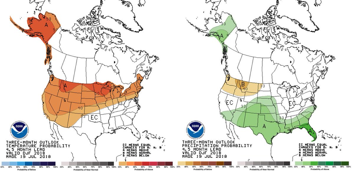
Early look at the CPC thinking for winter!
4 likes
Winter time post are almost exclusively focused on the DFW area.
-
weatherdude1108
- Category 5
- Posts: 4172
- Joined: Tue Dec 13, 2011 1:04 pm
- Location: Northwest Austin/Cedar Park, TX
Re: Texas Summer 2018
My brother sent me a tweet he found about Lubbock’s all-time warmest low temperature. I verified it with the NWS. The dewpoint was only 48, which usually means it drops lower than 81 (?). Insane! Wow. The low is what you count on to cool off. 


1 likes
The preceding post is NOT an official forecast, and should not be used as such. It is only the opinion of the poster and may or may not be backed by sound meteorological data. It is NOT endorsed by any professional institution including storm2k.org. For Official Information please refer to the NHC and NWS products.
-
CaptinCrunch

- S2K Supporter
- Posts: 8578
- Age: 56
- Joined: Mon Nov 03, 2003 4:33 pm
- Location: Lake Worth, TX (Tarrant Co.)
Re: Texas Summer 2018
bubba hotep wrote:Early look at the CPC thinking for winter!
CPC must be banking on late Fall El Nino to issue these maps. The EC on temps means nothing, but I do enjoy the greenage thru Winter
0 likes
-
Yukon Cornelius
- S2K Supporter
- Posts: 1738
- Age: 40
- Joined: Thu Dec 20, 2012 9:23 pm
- Location: Dean, TX/Westcliffe, CO
Re: Texas Summer 2018
3 PM temp in Wichita Falls - 111. This is getting out of hand.
2 likes
#neversummer
-
srainhoutx

- S2K Supporter
- Posts: 6919
- Age: 66
- Joined: Sun Jan 14, 2007 11:34 am
- Location: Haywood County, NC
- Contact:
Re: Texas Summer 2018
I continue to see changes in the Hemispheric Pattern as we head toward late July into August. The Afternoon Update CPC Day 8-14 Outlook suggest a very deep longwave trough becoming established East of the Rockies with temperatures cooling and rain chances increase. It is also noteworthy that a very impressive wet phase of the MJO suggesting rising air allowing thunderstorms to develop across the Eastern Pacific and Western Atlantic Basin in conjunction with the strongest Convectively Couple Kelvin Wave we've seen so far this year arrives as July end and August begins.
After a mix of weather doldrums and some rainy periods in early July, the pattern ahead suggest a much more active period may well be lurking. Water temperatures in the Gulf are very warm and can easily support tropical troubles, if they form. It's time to turn our attention toward the Gulf and Western Caribbean as well as for any Mesoscale Convective System that splash into the Gulf from the mainland and fester as Alicia did some 35 years ago. #ItOnlyTakesOne
After a mix of weather doldrums and some rainy periods in early July, the pattern ahead suggest a much more active period may well be lurking. Water temperatures in the Gulf are very warm and can easily support tropical troubles, if they form. It's time to turn our attention toward the Gulf and Western Caribbean as well as for any Mesoscale Convective System that splash into the Gulf from the mainland and fester as Alicia did some 35 years ago. #ItOnlyTakesOne
6 likes
Carla/Alicia/Jerry(In The Eye)/Michelle/Charley/Ivan/Dennis/Katrina/Rita/Wilma/Ike/Harvey
Member: National Weather Association
Wx Infinity Forums
http://wxinfinity.com/index.php
Facebook.com/WeatherInfinity
Twitter @WeatherInfinity
Member: National Weather Association
Wx Infinity Forums
http://wxinfinity.com/index.php
Facebook.com/WeatherInfinity
Twitter @WeatherInfinity
-
weatherdude1108
- Category 5
- Posts: 4172
- Joined: Tue Dec 13, 2011 1:04 pm
- Location: Northwest Austin/Cedar Park, TX
Re: Texas Summer 2018
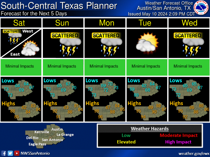
Meanwhile,
URGENT - WEATHER MESSAGE
National Weather Service Austin/San Antonio TX
314 PM CDT Thu Jul 19 2018
TXZ173-192-201100-
/O.NEW.KEWX.EH.W.0002.180720T1900Z-180721T0100Z/
/O.CON.KEWX.HT.Y.0002.000000T0000Z-180720T0100Z/
Williamson-Travis-
Including the cities of Georgetown and Austin
314 PM CDT Thu Jul 19 2018
...HEAT ADVISORY REMAINS IN EFFECT UNTIL 8 PM CDT THIS EVENING...
...EXCESSIVE HEAT WARNING IN EFFECT FROM 2 PM TO 8 PM CDT
FRIDAY...
The National Weather Service in Austin/San Antonio has issued an
Excessive Heat Warning, which is in effect from 2 PM to 8 PM CDT
Friday.
* TEMPERATURE...Afternoon and early evening temperatures ranging
from 102 to 104 degrees increasing to 105 Friday afternoon.
* IMPACTS...Very hot temperatures will increase the risk of heat
related illnesses such as heat exhaustion and heat stroke.
PRECAUTIONARY/PREPAREDNESS ACTIONS...
Take extra precautions if you must work or spend time outside.
Wear light weight and loose fitting clothing, drink plenty of
water, and take frequent breaks, preferably in an air conditioned
area. When possible reschedule strenuous activities during the
morning or mid evening hours. Be sure to check on persons with
health problems and the elderly, as they are the most susceptible
to heat exhaustion and heat stroke.
Know the signs and symptoms of heat exhaustion and heat stroke.
Anyone overcome by heat should be moved to a cool and shaded
location. Heat stroke is an emergency...call 9 1 1.
Young children and pets should never be left unattended in
vehicles under any circumstances. This is especially true during
hot weather when car interiors can reach lethal temperatures in a
matter of minutes. Look before you lock!
An Excessive Heat Warning means that a prolonged period of
dangerously hot temperatures will occur. The combination of hot
temperatures and high humidity will combine to create a dangerous
situation in which heat illnesses are likely. Drink plenty of
fluids...stay in an air-conditioned room...stay out of the sun...
and check up on relatives and neighbors.
&&
$$
Last edited by weatherdude1108 on Thu Jul 19, 2018 3:45 pm, edited 1 time in total.
0 likes
The preceding post is NOT an official forecast, and should not be used as such. It is only the opinion of the poster and may or may not be backed by sound meteorological data. It is NOT endorsed by any professional institution including storm2k.org. For Official Information please refer to the NHC and NWS products.
-
weatherdude1108
- Category 5
- Posts: 4172
- Joined: Tue Dec 13, 2011 1:04 pm
- Location: Northwest Austin/Cedar Park, TX
Re: Texas Summer 2018
Yukon Cornelius wrote:3 PM temp in Wichita Falls - 111. This is getting out of hand.
I remember one summer in June in the mid-90s, I was in Lubbock for summer school. It got up to 114 (a record high for that time) in Lubbock. They had laid fresh asphalt down a day or two prior on the roads I was commuting on. The roads were literally oozing up tar, getting all over the cars traveling on it. I had to use about a entire can of Bug & Tar Remover to get the tar off of the side of my car. It was a MESS! I actually saw the tar oozing out of the road in places.
0 likes
The preceding post is NOT an official forecast, and should not be used as such. It is only the opinion of the poster and may or may not be backed by sound meteorological data. It is NOT endorsed by any professional institution including storm2k.org. For Official Information please refer to the NHC and NWS products.
Return to “USA & Caribbean Weather”
Who is online
Users browsing this forum: No registered users and 91 guests