@NOAASatellites
#GOESEast is watching the tropical disturbance along the #Texas Gulf Coast. The National Weather Service is forecasting heavy #rain from #Houston to Corpus Christi over the next two days. Follow the storms in real-time: http://goo.gl/G74rVB @NWS
https://twitter.com/NOAASatellites/status/1009070542417289217
Texas Summer 2018
Moderator: S2k Moderators
Forum rules

The posts in this forum are NOT official forecast and should not be used as such. They are just the opinion of the poster and may or may not be backed by sound meteorological data. They are NOT endorsed by any professional institution or STORM2K.
-
cycloneye

- Admin

- Posts: 139070
- Age: 67
- Joined: Thu Oct 10, 2002 10:54 am
- Location: San Juan, Puerto Rico
Re: Texas Summer 2018
0 likes
Visit the Caribbean-Central America Weather Thread where you can find at first post web cams,radars
and observations from Caribbean basin members Click Here
and observations from Caribbean basin members Click Here

-
TeamPlayersBlue

- Category 5

- Posts: 3307
- Joined: Tue Feb 02, 2010 1:44 am
- Location: Denver/Applewood, CO
Re: Texas Summer 2018
Houston is so lucky that line east of town isnt parked on top of it. Possible another line is building in the GOM that will line up with us though.
0 likes
Personal Forecast Disclaimer:
The posts in this forum are NOT official forecast and should not be used as such. They are just the opinion of the poster and may or may not be backed by sound meteorological data. They are NOT endorsed by any professional institution or storm2k.org. For official information, please refer to the NHC and NWS products.
The posts in this forum are NOT official forecast and should not be used as such. They are just the opinion of the poster and may or may not be backed by sound meteorological data. They are NOT endorsed by any professional institution or storm2k.org. For official information, please refer to the NHC and NWS products.
-
sphelps8681
- Category 2

- Posts: 673
- Joined: Thu Aug 16, 2007 5:37 pm
- Location: Somewhere over the rainbow
Re: Texas Summer 2018
A friend of mine in Bridge City as water coming in her home. She is still rebuilding since loosing everything when Harvey hit. She just got sheetrock put back on walls. They are putting sand bags up hoping this will help. Still coming down good after having rain stop for a bit. This is not good for her.
1 likes
-
TeamPlayersBlue
- Category 5
- Posts: 3307
- Joined: Tue Feb 02, 2010 1:44 am
- Location: Denver/Applewood, CO
Re: Texas Summer 2018
Small, inconspicuous shower on radar just hit me and man it was much heavier than i expected. Quick half an inch in 20 minutes
1 likes
Personal Forecast Disclaimer:
The posts in this forum are NOT official forecast and should not be used as such. They are just the opinion of the poster and may or may not be backed by sound meteorological data. They are NOT endorsed by any professional institution or storm2k.org. For official information, please refer to the NHC and NWS products.
The posts in this forum are NOT official forecast and should not be used as such. They are just the opinion of the poster and may or may not be backed by sound meteorological data. They are NOT endorsed by any professional institution or storm2k.org. For official information, please refer to the NHC and NWS products.
-
Haris

- Category 5
- Posts: 1808
- Joined: Mon Nov 27, 2017 8:19 pm
- Location: ( Bee Cave) West Austin, Texas
Re: Texas Summer 2018

SLUG of moisture coming
1 likes
Weather geek and a storm spotter in West Austin. Not a degreed meteorologist. Big snow fan. Love rain and cold! Despise heat!
-
Clearcloudz

- Category 2
- Posts: 523
- Joined: Sun Jun 10, 2018 1:46 pm
- Location: Rosenberg TX
Re: Texas Summer 2018
Travis Herzog ABC 13
See full post in link Below:
https://www.facebook.com/ABC13TravisHerzog/
11:30AM TUESDAY UPDATE:
We’ve threaded the needle for much of the day between two large areas of intense rains, but I expect the radar to fill in with more storms over southeast Texas the next few hours. The band to our south I showed you in my earlier post has held together and is now moving inland.
If you see a flash of lightning or hear any rumbles of thunder, that’s a signal you might get more rain than you were hoping for (like what’s happening off to our east in Beaumont). These tropical air masses are so warm it’s difficult to get any lightning activity unless the storm reaches to incredible heights in the atmosphere where it’s cold enough for ice crystal growth and lightning formation. If that happens, you get a tremendous amount of rain as well because what goes up must come down.
Hopefully the rain I’m anticipating to develop will keep on moving and not stall or train over the same spots. We are under a flash flood watch until 7PM.
0 likes
-
PSUHiker31
- Tropical Storm

- Posts: 114
- Joined: Tue Oct 03, 2017 2:36 pm
Re: Texas Summer 2018
Some pretty heavy storms headed towards Austin... Multiple rounds too. I am excited.
0 likes
-
Nederlander
- S2K Supporter

- Posts: 1171
- Joined: Sat Jul 19, 2008 4:28 pm
- Location: Nederland, TX
Re: Texas Summer 2018
Made it back down to Port Arthur but just barely. Most roads are now impassable or close to it around Beaumont and areas south (Port Arthur, Nederland, Port Neches).
1 likes
-
Clearcloudz
- Category 2
- Posts: 523
- Joined: Sun Jun 10, 2018 1:46 pm
- Location: Rosenberg TX
Re: Texas Summer 2018
Nederlander wrote:Made it back down to Port Arthur but just barely. Most roads are now impassable or close to it around Beaumont and areas south (Port Arthur, Nederland, Port Neches).
The radar looks the same as it did yesterday, it saved Houston in a way since most of the energy is going into that band.
0 likes
-
PSUHiker31
- Tropical Storm
- Posts: 114
- Joined: Tue Oct 03, 2017 2:36 pm
Re: Texas Summer 2018
Btw I can't help but to look at the most recent GFS total precipitation for the event and laugh hysterically as it has no basis in reality in comparison to the radar.
1 likes
Disturbed Weather in NW Gulf
some Homes reported taking in water in Port Neches/Nederland and Bridge city 
1 likes
-
lrak

- S2K Supporter
- Posts: 1770
- Age: 57
- Joined: Thu Jun 21, 2007 2:48 pm
- Location: Corpus Christi, TX
Disturbed Weather in NW Gulf
Corpus is getting TRAINED WITH RAIN 
1 likes
AKA karl
Also
Personal Forecast Disclaimer:
My posts on this forum are NOT official forecast and should not be used as such. My posts are my basic observations and are definitely not backed by any "well some" meteorological knowledge. For official information, please refer to the NHC and NWS products.
Also
Personal Forecast Disclaimer:
My posts on this forum are NOT official forecast and should not be used as such. My posts are my basic observations and are definitely not backed by any "well some" meteorological knowledge. For official information, please refer to the NHC and NWS products.
-
stormreader
- Category 5
- Posts: 1242
- Joined: Fri Jun 24, 2011 10:58 am
Re: Texas Summer 2018
Just looking at visible sat over south Texas. Almost looks like an eye feature. Funny, eh 
0 likes
-
TheAustinMan

- Category 4

- Posts: 997
- Age: 24
- Joined: Mon Jul 08, 2013 4:26 pm
- Location: United States
- Contact:
Re: Texas Summer 2018
That's a pretty neat mid-level circulation spinning up the clouds down there in South Texas. A lot of moisture remains available in the Gulf of Mexico as evidenced by the thick convective activity over the waters.
1 MB. Source: Generated by myself; map generated in QGIS.

1 MB. Source: Generated by myself; map generated in QGIS.
2 likes


Treat my opinions with a grain of salt. For official information see your local weather service.
-
cycloneye
- Admin
- Posts: 139070
- Age: 67
- Joined: Thu Oct 10, 2002 10:54 am
- Location: San Juan, Puerto Rico
Re: Texas Summer 2018
@MJVentrice
ECMWF pushing out 5"+ rainfall QPF across eastern/southeastern Texas over the next 48 hours in association to a tropical low pressure system pushing in from the Gulf. Flooding in locations is likely.Also will result in a delayed browning of vegetation this Summer for E Texas.
https://twitter.com/MJVentrice/status/1009141266251214848
0 likes
Visit the Caribbean-Central America Weather Thread where you can find at first post web cams,radars
and observations from Caribbean basin members Click Here
and observations from Caribbean basin members Click Here
-
cycloneye
- Admin
- Posts: 139070
- Age: 67
- Joined: Thu Oct 10, 2002 10:54 am
- Location: San Juan, Puerto Rico
Re: Texas Summer 2018
@NWSCorpus
We have received a legitimate report of 11+" of rain that fell approx 7 miles southwest of Premont, TX last night and this morning. An exact value is not available as the rain gauge overflowed as it reached maximum capacity. #txwx
We have received a legitimate report of 11+" of rain that fell approx 7 miles southwest of Premont, TX last night and this morning. An exact value is not available as the rain gauge overflowed as it reached maximum capacity. #txwx
0 likes
Visit the Caribbean-Central America Weather Thread where you can find at first post web cams,radars
and observations from Caribbean basin members Click Here
and observations from Caribbean basin members Click Here
-
Clearcloudz
- Category 2
- Posts: 523
- Joined: Sun Jun 10, 2018 1:46 pm
- Location: Rosenberg TX
Re: Texas Summer 2018
Warning are starting to pop up around Houston suburbs.
Flash Flood Warning including Katy TX until 5:30 PM CDT
Flash Flood Warning including Rosenberg TX, Weston Lakes TX, Wallis TX until 3:45 PM CDT
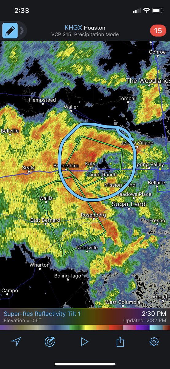
Flash Flood Warning including Katy TX until 5:30 PM CDT
Flash Flood Warning including Rosenberg TX, Weston Lakes TX, Wallis TX until 3:45 PM CDT
0 likes
-
Clearcloudz
- Category 2
- Posts: 523
- Joined: Sun Jun 10, 2018 1:46 pm
- Location: Rosenberg TX
Re: Texas Summer 2018
Nearly 3 inches of rain fell in Katy in 1 hour causing south mayde to start rising fast and its continuing to rain.

0 likes
-
Clearcloudz
- Category 2
- Posts: 523
- Joined: Sun Jun 10, 2018 1:46 pm
- Location: Rosenberg TX


Return to “USA & Caribbean Weather”
Who is online
Users browsing this forum: cheezyWXguy, cstrunk, Google Adsense [Bot], rwfromkansas, snownado, South Texas Storms, WacoWx and 166 guests