WPC disco earlier this morning
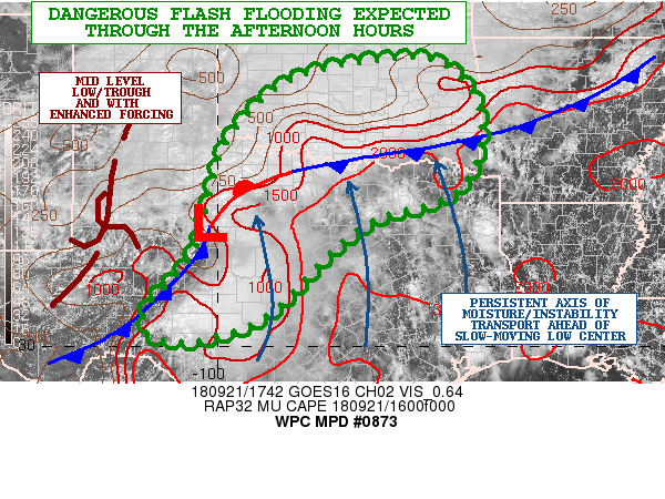
Mesoscale Precipitation Discussion 0872
NWS Weather Prediction Center College Park MD
737 AM EDT Fri Sep 21 2018
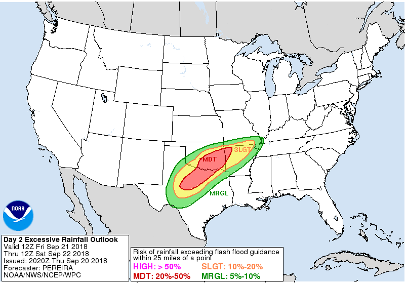
Areas affected...Northern TX into southern OK
Concerning...Heavy rainfall...Flash flooding likely
Valid 211136Z - 211736Z
Summary...Flash Flooding will become increasingly likely through
the morning hours from north central Texas into central Oklahoma.
For at least the southeastern half of the MPD area the flash flood
threat continues, and actually likely becomes more significant,
after the expiration of this MPD at 17z. This event as a whole
still appears to be evolving into a potentially significant and
locally life-threatening flash flood event as we head through the
day Friday.
Discussion...The environmental setup will become increasingly
favorable for heavy rainfall as we go through today. In the upper
levels, flow is impressively diffluent south of the upper jet to
the north. In the mid levels, have one or more embedded shortwave
features likely helping enhance lift. The lower levels feature a
cold front dropping south across KS/OK, with an area of low
pressure over west TX becoming better defined with time. Pretty
good southerly flow and 850mb moisture transport exists to the
east of this low. Anticipate the southward dropping cold front to
significantly slow its progression as it drops into southern OK
and interacts with the stronger southerly flow. Thus low level
convergence will become quite impressive with time today. The
combination of this impressive lower level convergence and upper
level diffluence is very supportive of broad deep layer ascent
over the area.
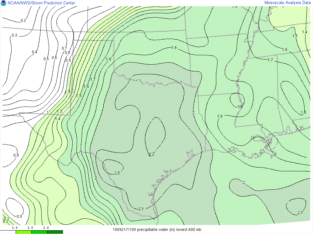
PWs will end up around 2.25"...which is near record values for
this time of year. Note a strong and deep moisture connection to
the Pacific...and the remnants of T.D. 19. Also have a moisture
plume advecting north out of the western Gulf. The merging of
these two moisture streams is responsible for the near record PW
values. Instability is probably the most marginal ingredient of
this setup...with MUCAPE generally below 1000 J/KG. However 3 hour
CAPE trends do show increasing values over the MPD area. Thus
while the marginal instability may prevent very deep and intense
cells from forming...there is likely enough CAPE, given the
efficient warm rain processes in play, to produce excessive
rainfall amounts.
Convection is beginning to expand from central TX into OK this
morning...and should only become more organized and intense as the
morning progresses. The MPD area aligns pretty well with the 06z
HREF neighborhood probabilities of 3"+ through 18z, and with the
QPF axis depicted in recent HRRR runs. Out of all available
guidance, would say that recent HRRR runs offer as good as any
starting point for convective expectations through the morning
into early afternoon hours. Although would not be surprised if the
flash flood threat ends up beginning a bit sooner than the HRRR
would suggest. Would anticipate pockets of 3-5" through 17z across
the MPD area, with these totals becoming more widespread and
higher beyond 17z.
Chenard
ATTN...WFO...FWD...LUB...MAF...OUN...SJT...TSA...
ATTN...RFC...ABRFC...WGRFC...


 and its not even close to over yet