Texas Fall 2018
Moderator: S2k Moderators
Forum rules

The posts in this forum are NOT official forecast and should not be used as such. They are just the opinion of the poster and may or may not be backed by sound meteorological data. They are NOT endorsed by any professional institution or STORM2K.
Re: Texas Fall 2018
By George we’re actually getting a decent shower at my casa right now! First one in over a month outside of just some light rain a few different times. Awesome!
2 likes
-
bubba hotep

- S2K Supporter

- Posts: 5457
- Joined: Wed Dec 28, 2016 1:00 am
- Location: Collin County Texas
Re: Texas Fall 2018
The airport should pick up some decent totals as this band starts to drift over

1 likes
Winter time post are almost exclusively focused on the DFW area.
-
bubba hotep
- S2K Supporter
- Posts: 5457
- Joined: Wed Dec 28, 2016 1:00 am
- Location: Collin County Texas
Re: Texas Fall 2018
TXWeatherMan wrote:It’s a long way out still but I see the FV3 and the GFS continue to show a good front around Halloween.
FV3 showing highs in the 40/30s statewide on the 2nd.

1 likes
Winter time post are almost exclusively focused on the DFW area.
-
weatherdude1108
- Category 5

- Posts: 4172
- Joined: Tue Dec 13, 2011 1:04 pm
- Location: Northwest Austin/Cedar Park, TX
Re: Texas Fall 2018
As much as I don't say this very often, I wouldn't mind seeing the sun for a few days.lol It would give the lakes a chance to balance out if anything. Aquifers in the region are looking much better too, with the Edwards Aquifer at 680. It was at 663 at this time last year.
000
FXUS64 KEWX 192011
AFDEWX
Area Forecast Discussion
National Weather Service Austin/San Antonio TX
311 PM CDT Fri Oct 19 2018
.SHORT TERM (Tonight through Saturday Night)...
Three focuses for additional rainfall through the afternoon and early
evening. The first will be along the tail end of mid level
disturbance moving through Central Texas leading to showers, with
some embedded moderate rainfall. We will continue the Flash Flood
Watch through 7 PM for Burnet, Williamson, and Travis counties to
account for this activity, where up to 1 inch of additional rainfall
will be possible. This activity should diminish in coverage later
this evening. The second area is closer to a weak surface boundary
across Fayette, Lavaca, and DeWitt counties and southwest into the
Coastal Bend where some pockets of moderate to heavy rainfall are
possible before also weakening later this evening. The third area is
associated with a mid level shortwave moving out of Mexico. Should
see an increase in coverage of light to pockets of moderate rainfall
through the afternoon and evening across Webb, Kinney, and Edwards
counties. Overall the intensity of this precip should not result in
significant flooding, so we are canceling the Flash Flood Watch
across the west, but will monitor closely. Closer to the San Antonio
area we have also cancelled the Flash Flood Watch as coverage is
expected to remain isolated and intensity light.
Scattered showers are in the forecast for Saturday, tending to favor
southern and western areas of the CWA through the afternoon and
evening as drier northerly low and mid level flow moves into the
area.
&&
.LONG TERM (Sunday through Friday)...
Isentropic ascent will increase along the Rio Grande Sunday while
drier mid level flow and downglide persists across the central and
eastern CWA. Precipitation chances should remain confined Sunday
closer to the Rio Grande.
Models are coming into better agreement with mid level flow returning
quickly from the southwest Sunday night into Monday. A disturbance in
the flow aloft will lead to increasing isentropic ascent and rainfall
should develop southwest to northeast overnight and through the day
on Monday. Some pockets of heavier rainfall could be possible as well
as an isolated thunderstorm or two. The disturbance shifts into the
eastern CWA Monday night. Rain chances have lowered Tuesday across
the CWA, with better focus remaining to the northwest.
The forecast confidence beyond Tuesday decreases considerably. Much
will be dependent on evolution of two Pacific storms and if and where
energy from these systems merge into the southwest flow aloft into
Texas. There appears to potentially be an increase in precipitation
Wednesday and then again late Thursday night into Friday. Again
confidence in timing and locations is low. However, if tap into the
southwest flow aloft from the Pacific does evolve then there could be
the potential for locally heavy rainfall at some point over the
region.
1 likes
The preceding post is NOT an official forecast, and should not be used as such. It is only the opinion of the poster and may or may not be backed by sound meteorological data. It is NOT endorsed by any professional institution including storm2k.org. For Official Information please refer to the NHC and NWS products.
-
weatherdude1108
- Category 5
- Posts: 4172
- Joined: Tue Dec 13, 2011 1:04 pm
- Location: Northwest Austin/Cedar Park, TX
Re: Texas Fall 2018
Bob Rose:
Rain amounts next week are shaping up to be significant, but not nearly as high as what occurred earlier this week. Totals are forecast to generally be in the range of 1-3 inches, with isolated heavier totals possible.
Mild temperatures are forecast next week, with highs mostly in the 60s and lows in the 50s.
A dry and sunny weather pattern is forecast to take shape Friday when a stable ridge of high pressure over the southwestern US spreads east across Texas. This ridge is predicted to remain over Texas next weekend and through a good part of the following week. The temperature is forecast to remain mild, with highs around 70 degrees and low temperatures in the 50s.
https://www.lcra.org/water/river-and-we ... ather.aspx
0 likes
The preceding post is NOT an official forecast, and should not be used as such. It is only the opinion of the poster and may or may not be backed by sound meteorological data. It is NOT endorsed by any professional institution including storm2k.org. For Official Information please refer to the NHC and NWS products.
-
Brent
- S2K Supporter
- Posts: 37096
- Age: 35
- Joined: Sun May 16, 2004 10:30 pm
- Location: Tulsa Oklahoma
- Contact:
Re: Texas Fall 2018
bubba hotep wrote:TXWeatherMan wrote:It’s a long way out still but I see the FV3 and the GFS continue to show a good front around Halloween.
FV3 showing highs in the 40/30s statewide on the 2nd.
https://www.tropicaltidbits.com/analysis/models/fv3p/2018101912/fv3p_T2m_eus_59.png
also had some snow in W TX
0 likes
#neversummer
-
bubba hotep
- S2K Supporter
- Posts: 5457
- Joined: Wed Dec 28, 2016 1:00 am
- Location: Collin County Texas
Re: Texas Fall 2018
Models continue to struggle with the EPAC systems and how they eventually interact with mid-lat flow but the 18z GFS is back to a more widespread rain event.

1 likes
Winter time post are almost exclusively focused on the DFW area.
-
bubba hotep
- S2K Supporter
- Posts: 5457
- Joined: Wed Dec 28, 2016 1:00 am
- Location: Collin County Texas
Re: Texas Fall 2018
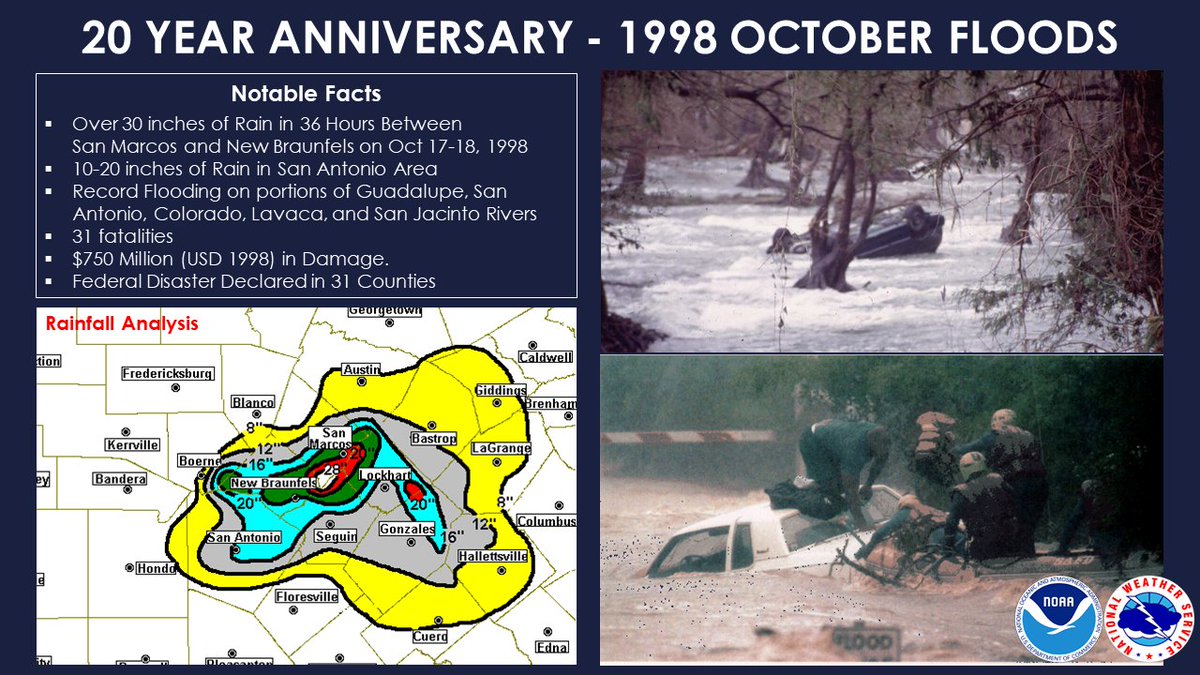
bubba hotep wrote:https://pbs.twimg.com/media/DpvRBuNWwAUqrYI.jpg
Amazing totals and I do not remember this at all. I wonder what the setup was?
1 likes

Re: Texas Fall 2018
gpsnowman wrote:bubba hotep wrote:https://pbs.twimg.com/media/DpvRBuNWwAUqrYI.jpg
Amazing totals and I do not remember this at all. I wonder what the setup was?
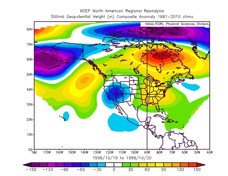
A quick reanalysis shows two things for this event. And you probably can easily guess what the ingredients were. First off you have a cutoff slow southwest trough creating diverging jet bringing up precipitous amount of Eastern Pacific moisture. At the same time Hurricane Madeline paralleled the western Mexican coast in the EPAC. Its remnants merged with the upper trough and yielded prolific rains in South Texas. The Great Floods in the State during the Fall, in particular (as this year is) almost always occur the same way when you are talking the inland empires. Textbook, if I were a student studying Texas floods this is a good area to look into.
"Although Madeline never crossed the coast, numerous rainbands affected the Mexican coast, dropping up to 9.8 in (250 mm).[17] Despite this, no damage or fatalities were reported in Mexico.[2] After the storm had dissipated, the remnant plume of moisture contributed to severe flooding in central Texas.[18] Rainfall in Texas reached 22 inches (560 mm) in some locations. Thirty-one people died due to the flooding, and damage totaled to $750 million (1998 USD).[19] A total of 24 of the deaths were drownings, 22 of them were caused by driving vehicles into high water on a road flooded by the torrential downpours. There were 16 different incidents when these types of deaths occurred, four of them involving in multiple deaths. Three others died due to trauma, and one died from hypothermia after the person was submerged in the water.[20] The greatest impact was in Southern Texas, which included the urban areas of San Antonio and Austin, and all of their surrounding suburbs. The counties with the most significant rainfall, damage, and fatalities were Travis County, Bexar County, Guadalupe County, Comal County, and Caldwell County. This area included both the cities of San Antonio and Austin. In a small area in Caldwell County, there was 29 inches (740 mm) of rain estimated by the United States Geological Survey. This included the area of Lockhart, Texas, which was badly flooded by the storm due to its close proximity to the San Marcos River. Most of the county picked up an estimated 20 to 30 in (510 to 760 mm) of rain, including San Marcos, Texas, New Braunfels, Texas, and Kyle, Texas.[21] In all, portions of 60 counties in Texas were flooded and hundreds of people were forced to flee their homes.[22]
Due to the flooding, twenty counties were declared federal disaster areas, clearing the way for assistance such as federal loans. Then-president Bill Clinton promised aid to the victims of the storm and then-governor George W. Bush took a tour of the devastated region with the Federal Emergency Management Agency director."
4 likes
The above post and any post by Ntxw is NOT an official forecast and should not be used as such. It is just the opinion of the poster and may or may not be backed by sound meteorological data. It is NOT endorsed by any professional institution including Storm2k. For official information, please refer to NWS products.
Help support Storm2K!
Re: Texas Fall 2018
Thanks for the info Ntwx. I figured it had to be something similar to what Texas has experienced the past week or so. And a great post from Bubba. That is a lot of water in such a short period.
0 likes
-
bubba hotep
- S2K Supporter
- Posts: 5457
- Joined: Wed Dec 28, 2016 1:00 am
- Location: Collin County Texas
Re: Texas Fall 2018
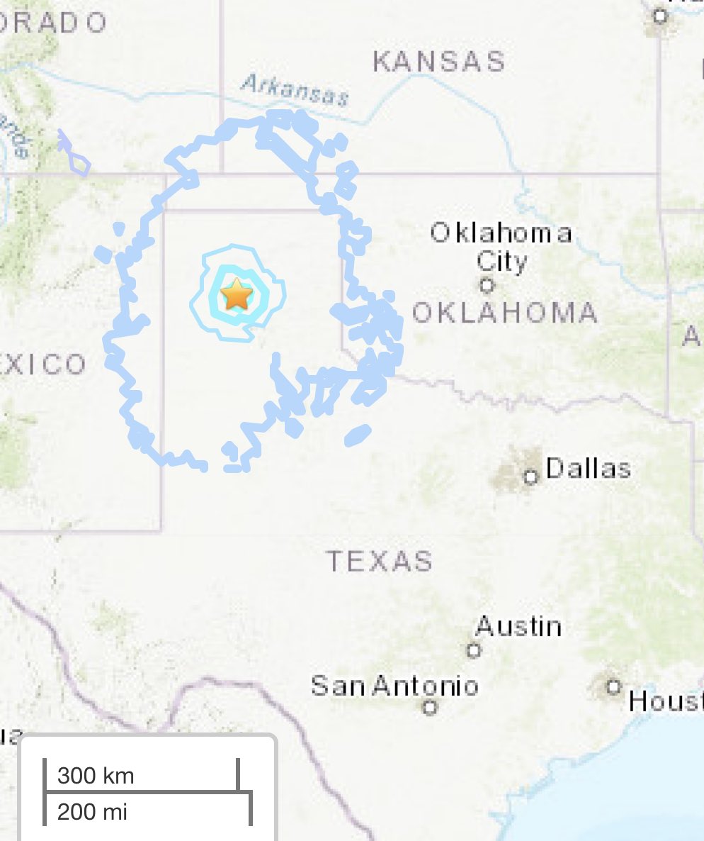
M4.0 near Amarillo, TX
0 likes
Winter time post are almost exclusively focused on the DFW area.
-
weatherdude1108
- Category 5
- Posts: 4172
- Joined: Tue Dec 13, 2011 1:04 pm
- Location: Northwest Austin/Cedar Park, TX
Re: Texas Fall 2018
Ntxw wrote:gpsnowman wrote:bubba hotep wrote:https://pbs.twimg.com/media/DpvRBuNWwAUqrYI.jpg
Amazing totals and I do not remember this at all. I wonder what the setup was?
A quick reanalysis shows two things for this event. And you probably can easily guess what the ingredients were. First off you have a cutoff slow southwest trough creating diverging jet bringing up precipitous amount of Eastern Pacific moisture. At the same time Hurricane Madeline paralleled the western Mexican coast in the EPAC. Its remnants merged with the upper trough and yielded prolific rains in South Texas. The Great Floods in the State during the Fall, in particular (as this year is) almost always occur the same way when you are talking the inland empires. Textbook, if I were a student studying Texas floods this is a good area to look into.
https://images2.imgbox.com/b8/c6/Q2r63I8O_o.jpg
"Although Madeline never crossed the coast, numerous rainbands affected the Mexican coast, dropping up to 9.8 in (250 mm).[17] Despite this, no damage or fatalities were reported in Mexico.[2] After the storm had dissipated, the remnant plume of moisture contributed to severe flooding in central Texas.[18] Rainfall in Texas reached 22 inches (560 mm) in some locations. Thirty-one people died due to the flooding, and damage totaled to $750 million (1998 USD).[19] A total of 24 of the deaths were drownings, 22 of them were caused by driving vehicles into high water on a road flooded by the torrential downpours. There were 16 different incidents when these types of deaths occurred, four of them involving in multiple deaths. Three others died due to trauma, and one died from hypothermia after the person was submerged in the water.[20] The greatest impact was in Southern Texas, which included the urban areas of San Antonio and Austin, and all of their surrounding suburbs. The counties with the most significant rainfall, damage, and fatalities were Travis County, Bexar County, Guadalupe County, Comal County, and Caldwell County. This area included both the cities of San Antonio and Austin. In a small area in Caldwell County, there was 29 inches (740 mm) of rain estimated by the United States Geological Survey. This included the area of Lockhart, Texas, which was badly flooded by the storm due to its close proximity to the San Marcos River. Most of the county picked up an estimated 20 to 30 in (510 to 760 mm) of rain, including San Marcos, Texas, New Braunfels, Texas, and Kyle, Texas.[21] In all, portions of 60 counties in Texas were flooded and hundreds of people were forced to flee their homes.[22]
Due to the flooding, twenty counties were declared federal disaster areas, clearing the way for assistance such as federal loans. Then-president Bill Clinton promised aid to the victims of the storm and then-governor George W. Bush took a tour of the devastated region with the Federal Emergency Management Agency director."
I remember this totally! I lived in SA. My dad and I emptied our 5 inch rain gauge about 3 times that day! It was incredible! I believe there was also a stationary front involved in the mix(?).
1 likes
The preceding post is NOT an official forecast, and should not be used as such. It is only the opinion of the poster and may or may not be backed by sound meteorological data. It is NOT endorsed by any professional institution including storm2k.org. For Official Information please refer to the NHC and NWS products.
-
Haris

- Category 5
- Posts: 1808
- Joined: Mon Nov 27, 2017 8:19 pm
- Location: ( Bee Cave) West Austin, Texas
Re: Texas Fall 2018

Hurst Harbor parking lot underwater,
drone pic I took from today
0 likes
Weather geek and a storm spotter in West Austin. Not a degreed meteorologist. Big snow fan. Love rain and cold! Despise heat!
-
Haris
- Category 5
- Posts: 1808
- Joined: Mon Nov 27, 2017 8:19 pm
- Location: ( Bee Cave) West Austin, Texas
Re: Texas Fall 2018


Drought vs no drought...
Lakeway Park! AMAZING!
2 likes
Weather geek and a storm spotter in West Austin. Not a degreed meteorologist. Big snow fan. Love rain and cold! Despise heat!
Re: Texas Fall 2018
The NAM is showing quite a bit of rain for parts of the Hill Country again.
2 likes
-
weatherdude1108
- Category 5
- Posts: 4172
- Joined: Tue Dec 13, 2011 1:04 pm
- Location: Northwest Austin/Cedar Park, TX
Re: Texas Fall 2018

Several approaching systems will result in periods of rain during the upcoming week. Some of this rain may be locally heavy at times Monday through Wednesday. Rivers and lakes are expected to remain elevated over the next few days and additional rainfall may prolong these elevated conditions.
1 likes
The preceding post is NOT an official forecast, and should not be used as such. It is only the opinion of the poster and may or may not be backed by sound meteorological data. It is NOT endorsed by any professional institution including storm2k.org. For Official Information please refer to the NHC and NWS products.
Re: Texas Fall 2018
Cpv17 wrote:So when should we expect our next significant cool down?
The weekend before Halloween.
Before that, it turns out it's not Vicente that is re-curving, it is Willa since a TC formed near Guatamala before 99E (now Willa) but short lived. Got to watch that Hurricane as well as remnants of Vicente for rains. Models can be poor handling the qpf with these systems once they move into the low observed areas of NW Mexico. But I do expect flood watches to once again be put up for much of the state that have already been saturated.
This will only makes things worse for the lakes and rivers. Somebody will get a foot of rain out of this, I'd bet a hedge fund on it.
3 likes
The above post and any post by Ntxw is NOT an official forecast and should not be used as such. It is just the opinion of the poster and may or may not be backed by sound meteorological data. It is NOT endorsed by any professional institution including Storm2k. For official information, please refer to NWS products.
Help support Storm2K!
Help support Storm2K!
-
TheProfessor

- Professional-Met

- Posts: 3505
- Age: 27
- Joined: Tue Dec 03, 2013 10:56 am
- Location: Wichita, Kansas
Re: Texas Fall 2018
Willa will definitely be an interesting storm. Might end up fulling a big time east coast storm down the road.
1 likes
An alumnus of The Ohio State University.
Your local National Weather Service office is your best source for weather information.
Your local National Weather Service office is your best source for weather information.
Return to “USA & Caribbean Weather”
Who is online
Users browsing this forum: Brent and 152 guests