
Texas Fall 2018
Moderator: S2k Moderators
Forum rules

The posts in this forum are NOT official forecast and should not be used as such. They are just the opinion of the poster and may or may not be backed by sound meteorological data. They are NOT endorsed by any professional institution or STORM2K.
Re: Texas Fall 2018
Tropical storm Tara in the EPAC is looking like the moisture plume associated will be injected to the flow. Should see significant increase in rain coverage across the state than what currently sits later this evening into tomorrow.
5 likes
The above post and any post by Ntxw is NOT an official forecast and should not be used as such. It is just the opinion of the poster and may or may not be backed by sound meteorological data. It is NOT endorsed by any professional institution including Storm2k. For official information, please refer to NWS products.
Help support Storm2K!
Re: Texas Fall 2018
I’m watching MNF tonight and it’s 38 degrees in Green Bay, Wisconsin. There’s areas in central Texas tonight where it’s just as cold or colder..weird.
0 likes
-
Brent
- S2K Supporter

- Posts: 37092
- Age: 35
- Joined: Sun May 16, 2004 10:30 pm
- Location: Tulsa Oklahoma
- Contact:
Re: Texas Fall 2018
Cpv17 wrote:I’m watching MNF tonight and it’s 38 degrees in Green Bay, Wisconsin. There’s areas in central Texas tonight where it’s just as cold or colder..weird.
I'm in Chicago and the TV met kept mentioning how cold Dallas was through half the weather segment it was crazy
0 likes
#neversummer
-
Haris

- Category 5

- Posts: 1808
- Joined: Mon Nov 27, 2017 8:19 pm
- Location: ( Bee Cave) West Austin, Texas
Re: Texas Fall 2018
oh wow!
Lake Travis has gone up to 667FT!!!
With more rain ongoing over CTX, it will continue to rise.
Back in August, it was 653! Here in Austin, it is a very important drinking water source! This is fantastic to hear!!!
Keep the rain train going!
Lake Travis has gone up to 667FT!!!
With more rain ongoing over CTX, it will continue to rise.
Back in August, it was 653! Here in Austin, it is a very important drinking water source! This is fantastic to hear!!!
Keep the rain train going!
3 likes
Weather geek and a storm spotter in West Austin. Not a degreed meteorologist. Big snow fan. Love rain and cold! Despise heat!
-
bubba hotep

- S2K Supporter
- Posts: 5456
- Joined: Wed Dec 28, 2016 1:00 am
- Location: Collin County Texas
Re: Texas Fall 2018
Euro Weeklies Control run has nearly 2' of rain for DFW through the end of November and based on the pattern, it just my verify 
2 likes
Winter time post are almost exclusively focused on the DFW area.
Re: Texas Fall 2018
bubba hotep wrote:Euro Weeklies Control run has nearly 2' of rain for DFW through the end of November and based on the pattern, it just my verify
The EPAC is experiencing a historical season for the record books. I am not surprised our rain fortunes have flipped since July, when the EPAC too flipped after being dead. I would not be shocked if we see additional re-curving systems (Nov 2015 Sandra) like event that month.
3 likes
The above post and any post by Ntxw is NOT an official forecast and should not be used as such. It is just the opinion of the poster and may or may not be backed by sound meteorological data. It is NOT endorsed by any professional institution including Storm2k. For official information, please refer to NWS products.
Help support Storm2K!
Help support Storm2K!
Re: Texas Fall 2018
Ntxw wrote:bubba hotep wrote:Euro Weeklies Control run has nearly 2' of rain for DFW through the end of November and based on the pattern, it just my verify
The EPAC is experiencing a historical season for the record books. I am not surprised our rain fortunes have flipped since July, when the EPAC too flipped after being dead. I would not be shocked if we see additional re-curving systems (Nov 2015 Sandra) like event that month.
When does the EPAC hurricane season usually wind down?
0 likes
Re: Texas Fall 2018
Cpv17 wrote:Ntxw wrote:bubba hotep wrote:Euro Weeklies Control run has nearly 2' of rain for DFW through the end of November and based on the pattern, it just my verify
The EPAC is experiencing a historical season for the record books. I am not surprised our rain fortunes have flipped since July, when the EPAC too flipped after being dead. I would not be shocked if we see additional re-curving systems (Nov 2015 Sandra) like event that month.
When does the EPAC hurricane season usually wind down?
November 30th. Storms that occur late in the season always re-curves due to the westerlies and descending jet stream from the changing seasons. You can get Cat 4s forming in November there. EPAC re-curve season really occurs in two spurts. First it can happen in May or June (our spring wettest months) and Fall usually September-October and during busy seasons November.
The EPAC is for Texas what the Gulf is for Southeastern States such as Georgia and Florida when it comes to upstream tropical remnants.
2 likes
The above post and any post by Ntxw is NOT an official forecast and should not be used as such. It is just the opinion of the poster and may or may not be backed by sound meteorological data. It is NOT endorsed by any professional institution including Storm2k. For official information, please refer to NWS products.
Help support Storm2K!
Help support Storm2K!
-
weatherdude1108
- Category 5
- Posts: 4172
- Joined: Tue Dec 13, 2011 1:04 pm
- Location: Northwest Austin/Cedar Park, TX
Re: Texas Fall 2018
Haris wrote:oh wow!
Lake Travis has gone up to 667FT!!!
With more rain ongoing over CTX, it will continue to rise.
Back in August, it was 653! Here in Austin, it is a very important drinking water source! This is fantastic to hear!!!
Keep the rain train going!
Yeah, I've been following that. The Highland Laked usually get the short end of the rain stick, but not lately. Buchanan has also risen to 2013 feet or so (full is 2018-2021).
https://hydromet.lcra.org
0 likes
The preceding post is NOT an official forecast, and should not be used as such. It is only the opinion of the poster and may or may not be backed by sound meteorological data. It is NOT endorsed by any professional institution including storm2k.org. For Official Information please refer to the NHC and NWS products.
-
weatherdude1108
- Category 5
- Posts: 4172
- Joined: Tue Dec 13, 2011 1:04 pm
- Location: Northwest Austin/Cedar Park, TX
Re: Texas Fall 2018
Brent wrote:Cpv17 wrote:I’m watching MNF tonight and it’s 38 degrees in Green Bay, Wisconsin. There’s areas in central Texas tonight where it’s just as cold or colder..weird.
I'm in Chicago and the TV met kept mentioning how cold Dallas was through half the weather segment it was crazy
Our local TV westherdude David Yeomans said it was colder in Austin than it was in Anchorage and Chicago.lol. My brother in DC said it was colder in Austin than DC. Sounds like El Niño.
2 likes
The preceding post is NOT an official forecast, and should not be used as such. It is only the opinion of the poster and may or may not be backed by sound meteorological data. It is NOT endorsed by any professional institution including storm2k.org. For Official Information please refer to the NHC and NWS products.
-
weatherdude1108
- Category 5
- Posts: 4172
- Joined: Tue Dec 13, 2011 1:04 pm
- Location: Northwest Austin/Cedar Park, TX
Re: Texas Fall 2018
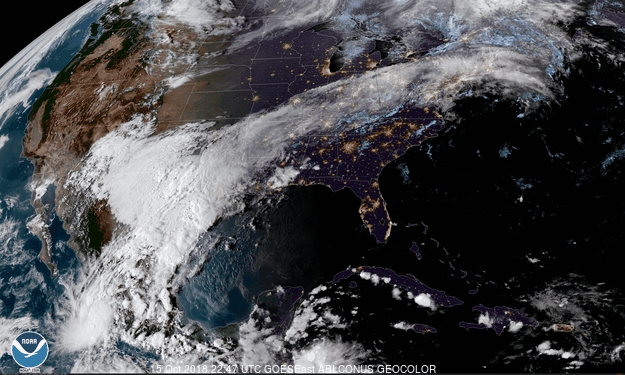
Area Forecast Discussion
National Weather Service Austin/San Antonio TX
921 PM CDT Mon Oct 15 2018
.UPDATE...
While the ongoing forecast is in good shape minor tweaks were made
to the QPF, PoP, and weather grids to reflect ongoing radar trends
and to align the forecast with what the high resolution models show
for the rest of the night.
A flash flood situation has developed across the Hill Country
through the evening as 1 to 3 inches of rain have fallen over the
last 6 hours, bringing the daily total across much of Llano,
Gillespie, and parts of Burnet county up to 5 to 6 inches. While this
rain has fallen over several hours the ground is so saturated from
recent rains that anything that falls is turning into runoff
resulting in Flash Flooding across these areas. Reports from county
EMs and sheriffs offices in Llano and Gillespie county show that
multiple roads are closed across both counties due to water over the
roadways. This include roads that typically do not flood or are not
considered low water crossings. The message tonight across the Hill
Country is that if you don`t have to get out and travel, stay home.
Flooded roadways at night are difficult to detect, and with such
widespread flooding and multiple roads closed being out and about
across these areas tonight is dangerous.
Over the next several hours the HRRR, Texas Tech WRF, and other high
resolution models show rainfall moderate rain continuing to move
northeast over the Edwards Plateau and Hill Country before lifting
northward out of the area Tuesday morning. Because of the saturated
soils this has become less about intense rainfall rates, and more
about longer duration rains resulting in runoff and flooding. Flash
and River Flooding will continue to be a possibility through the
night from Edwards through Kerr, Gillespie, up to Llano and Burnet
Counties. Area rivers have also responded to the rainfall with parts
of the Nueces, Guadalupe, and Llano Rivers all above flood stage
tonight.
To those along and east of I-35 isolated to scattered light rain will
be possible through the overnight hours with lows dropping into the
mid to upper 40s.
0 likes
The preceding post is NOT an official forecast, and should not be used as such. It is only the opinion of the poster and may or may not be backed by sound meteorological data. It is NOT endorsed by any professional institution including storm2k.org. For Official Information please refer to the NHC and NWS products.
-
weatherdude1108
- Category 5
- Posts: 4172
- Joined: Tue Dec 13, 2011 1:04 pm
- Location: Northwest Austin/Cedar Park, TX
Re: Texas Fall 2018
Last Update: Oct 15 2018 10:37PM
Summary
Floodgate operations are underway at Wirtz Dam, which forms Lake LBJ, and Starcke Dam, which forms Lake Marble Falls.
Water will be moving fast through lakes LBJ, Marble Falls and the upper end of Lake Travis as the flood water is passed through the lakes. Water will be higher than usual at the upper ends of lakes LBJ and Marble Falls and Travis.
Rainfall continues to fall over the Highland Lakes watershed this evening. The heaviest rain has fallen generally along a line from Harper to Llano to Lampasas. Along this line, 24-hour rainfall totals range from 3 to 6 inches over portions of the Llano River, Sandy Creek, Pedernales River, Cherokee Creek watersheds and areas upstream of Lake Buchanan.
The Llano River at Llano rose above flood stage the morning of Oct. 15 at 10 a.m., and continues to run high. This water will continue to flow through lakes LBJ, Marble Falls and Travis overnight on Oct. 15-16. Hydroelectric generation and floodgate operations are in progress at Wirtz and Starcke dams to pass floodwaters through Wirtz and Starcke dams. Releases from Starcke Dam are flowing into Lake Travis. Storm runoff from areas upstream of Buchanan Dam are flowing into Lake Buchanan.
https://floodstatus.lcra.org
0 likes
The preceding post is NOT an official forecast, and should not be used as such. It is only the opinion of the poster and may or may not be backed by sound meteorological data. It is NOT endorsed by any professional institution including storm2k.org. For Official Information please refer to the NHC and NWS products.
-
weatherdude1108
- Category 5
- Posts: 4172
- Joined: Tue Dec 13, 2011 1:04 pm
- Location: Northwest Austin/Cedar Park, TX
Re: Texas Fall 2018
3 inches at house since yesterday. Still raining.
Lakes Travis and Buchanan are almost full!

Summary Last Update: Oct 16 2018 4:34AM
Floodgate operations are underway at Wirtz Dam, which forms Lake LBJ, and Starcke Dam, which forms Lake Marble Falls.
Water will be moving fast through lakes LBJ, Marble Falls and the upper end of Lake Travis as the flood water is passed through the lakes. Water will be higher than usual at the upper ends of lakes LBJ and Marble Falls and Travis.
Rainfall continues to fall over the Highland Lakes watershed this evening. The heaviest rain has fallen generally along a line from Harper to Llano to Lampasas. Along this line, 24-hour rainfall totals range from 3 to over 8 inches over portions of the Llano River, Sandy Creek, Pedernales River, Cherokee Creek watersheds and areas upstream of Lake Buchanan. Storm runoff is expected to cause the river and tributaries to exceed flood stage at many locations.
The Llano River at Mason and Llano and Sandy Creek near Kingsland are above flood stage and rising as rain continues to fall in the area. This water will flow through lakes LBJ, Marble Falls and Travis overnight on Oct. 15-16. Hydroelectric generation and floodgate operations are in progress at Wirtz and Starcke dams to pass floodwaters through Wirtz and Starcke dams. Releases from Starcke Dam will be caught in Lake Travis causing the level to rise quickly. Storm runoff from areas upstream of Buchanan Dam will be caught in Lake Buchanan which will also rise. The watershed is saturated and conditions can change quickly with additional rainfall.
Storm runoff from areas upstream of Buchanan Dam will be caught in Lake Buchanan.
Lake Buchanan
Floodgate Operations and Forecasts
Last Update: Oct 16 2018 4:34AM
Inflows: Inflows to Lake Buchanan are below levels that would require gate operations to pass floodwaters at Buchanan Dam.
Gate Operations: No gate operations to pass floodwaters are expected at Buchanan Dam at this time.
Lake level forecast: The level of Lake Buchanan is expected to rise to a range of 1015 to 1017 feet msl in the next 24 hours.
Max Reading: 1014.2 Oct 16 2018 4:30AM
Last Reading: 1014.2 Oct 16 2018 4:30AM
Lake Travis
Floodgate Operations and Forecasts
Last Update: Oct 16 2018 4:34AM
Inflows: Inflows to Lake Travis from Starck Dam remain high, but are below levels that would require gate operations to pass floodwaters at Mansfield Dam.
Gate Operations: No gate operations to pass floodwaters are expected at Mansfield Dam at this time.
Lake level forecast: Inflows to Lake Travis from Starcke Dam will cause fast moving currents and higher than usual water levels on the upper end of Lake Travis. The level of Lake Travis is expected to rise within a range of 678 to 680 feet msl within the next 24 hours.
Max Reading: 669.48 Oct 16 2018 4:30AM
Last Reading: 669.48 Oct 16 2018 4:30AM
https://hydromet.lcra.org
https://floodstatus.lcra.org
Lakes Travis and Buchanan are almost full!
Summary Last Update: Oct 16 2018 4:34AM
Floodgate operations are underway at Wirtz Dam, which forms Lake LBJ, and Starcke Dam, which forms Lake Marble Falls.
Water will be moving fast through lakes LBJ, Marble Falls and the upper end of Lake Travis as the flood water is passed through the lakes. Water will be higher than usual at the upper ends of lakes LBJ and Marble Falls and Travis.
Rainfall continues to fall over the Highland Lakes watershed this evening. The heaviest rain has fallen generally along a line from Harper to Llano to Lampasas. Along this line, 24-hour rainfall totals range from 3 to over 8 inches over portions of the Llano River, Sandy Creek, Pedernales River, Cherokee Creek watersheds and areas upstream of Lake Buchanan. Storm runoff is expected to cause the river and tributaries to exceed flood stage at many locations.
The Llano River at Mason and Llano and Sandy Creek near Kingsland are above flood stage and rising as rain continues to fall in the area. This water will flow through lakes LBJ, Marble Falls and Travis overnight on Oct. 15-16. Hydroelectric generation and floodgate operations are in progress at Wirtz and Starcke dams to pass floodwaters through Wirtz and Starcke dams. Releases from Starcke Dam will be caught in Lake Travis causing the level to rise quickly. Storm runoff from areas upstream of Buchanan Dam will be caught in Lake Buchanan which will also rise. The watershed is saturated and conditions can change quickly with additional rainfall.
Storm runoff from areas upstream of Buchanan Dam will be caught in Lake Buchanan.
Lake Buchanan
Floodgate Operations and Forecasts
Last Update: Oct 16 2018 4:34AM
Inflows: Inflows to Lake Buchanan are below levels that would require gate operations to pass floodwaters at Buchanan Dam.
Gate Operations: No gate operations to pass floodwaters are expected at Buchanan Dam at this time.
Lake level forecast: The level of Lake Buchanan is expected to rise to a range of 1015 to 1017 feet msl in the next 24 hours.
Max Reading: 1014.2 Oct 16 2018 4:30AM
Last Reading: 1014.2 Oct 16 2018 4:30AM
Lake Travis
Floodgate Operations and Forecasts
Last Update: Oct 16 2018 4:34AM
Inflows: Inflows to Lake Travis from Starck Dam remain high, but are below levels that would require gate operations to pass floodwaters at Mansfield Dam.
Gate Operations: No gate operations to pass floodwaters are expected at Mansfield Dam at this time.
Lake level forecast: Inflows to Lake Travis from Starcke Dam will cause fast moving currents and higher than usual water levels on the upper end of Lake Travis. The level of Lake Travis is expected to rise within a range of 678 to 680 feet msl within the next 24 hours.
Max Reading: 669.48 Oct 16 2018 4:30AM
Last Reading: 669.48 Oct 16 2018 4:30AM
https://hydromet.lcra.org
https://floodstatus.lcra.org
Last edited by weatherdude1108 on Tue Oct 16, 2018 8:48 am, edited 1 time in total.
1 likes
The preceding post is NOT an official forecast, and should not be used as such. It is only the opinion of the poster and may or may not be backed by sound meteorological data. It is NOT endorsed by any professional institution including storm2k.org. For Official Information please refer to the NHC and NWS products.
Re: Texas Fall 2018
Another steady rain morning at 45F for DFW. Absolutely love it. Will be warming into sizzling 50s after today. Very sad to see it go but winter is coming! Rain chances remain rest of the week.
We watch and wait what happens off Central America on the Pacific side for Vicente.
We watch and wait what happens off Central America on the Pacific side for Vicente.
3 likes
The above post and any post by Ntxw is NOT an official forecast and should not be used as such. It is just the opinion of the poster and may or may not be backed by sound meteorological data. It is NOT endorsed by any professional institution including Storm2k. For official information, please refer to NWS products.
Help support Storm2K!
Help support Storm2K!
-
1900hurricane

- Category 5
- Posts: 6044
- Age: 32
- Joined: Fri Feb 06, 2015 12:04 pm
- Location: Houston, TX
- Contact:
Re: Texas Fall 2018
Some of the Hill Country basins (especially the Llano Basin) got crushed overnight.
0 likes
Contract Meteorologist. TAMU & MSST. Fiercely authentic, one of a kind. We are all given free will, so choose a life meant to be lived. We are the Masters of our own Stories.
Opinions expressed are mine alone.
Follow me on Twitter at @1900hurricane : Read blogs at https://1900hurricane.wordpress.com/
Opinions expressed are mine alone.
Follow me on Twitter at @1900hurricane : Read blogs at https://1900hurricane.wordpress.com/
-
rwfromkansas
- Category 5
- Posts: 2165
- Joined: Sat Aug 27, 2005 12:47 am
- Location: North Fort Worth
Re: Texas Fall 2018
Seeing some streams I have never seen full in previous rains flowing strong today.
0 likes
-
weatherdude1108
- Category 5
- Posts: 4172
- Joined: Tue Dec 13, 2011 1:04 pm
- Location: Northwest Austin/Cedar Park, TX
Re: Texas Fall 2018
Kind of a scary situation along the Llano River. Drought to flood. 
There is a live feed going on this link.
https://www.kxan.com/news/local/hill-co ... pegrRF1HYU
There is a live feed going on this link.
https://www.kxan.com/news/local/hill-co ... pegrRF1HYU
Last edited by weatherdude1108 on Tue Oct 16, 2018 8:48 am, edited 3 times in total.
0 likes
The preceding post is NOT an official forecast, and should not be used as such. It is only the opinion of the poster and may or may not be backed by sound meteorological data. It is NOT endorsed by any professional institution including storm2k.org. For Official Information please refer to the NHC and NWS products.
Re: Texas Fall 2018
rwfromkansas wrote:Seeing some streams I have never seen full in previous rains flowing strong today.
Yeah I'm seeing low ditches becoming rivers. This is going to be a great water year for the Lakes.
In the span of about 45 days DFW has seen over 20" of rain!
2 likes
The above post and any post by Ntxw is NOT an official forecast and should not be used as such. It is just the opinion of the poster and may or may not be backed by sound meteorological data. It is NOT endorsed by any professional institution including Storm2k. For official information, please refer to NWS products.
Help support Storm2K!
Help support Storm2K!
-
1900hurricane
- Category 5
- Posts: 6044
- Age: 32
- Joined: Fri Feb 06, 2015 12:04 pm
- Location: Houston, TX
- Contact:
Re: Texas Fall 2018
FM 2900 bridge over the Llano River just gave way.
0 likes
Contract Meteorologist. TAMU & MSST. Fiercely authentic, one of a kind. We are all given free will, so choose a life meant to be lived. We are the Masters of our own Stories.
Opinions expressed are mine alone.
Follow me on Twitter at @1900hurricane : Read blogs at https://1900hurricane.wordpress.com/
Opinions expressed are mine alone.
Follow me on Twitter at @1900hurricane : Read blogs at https://1900hurricane.wordpress.com/
-
weatherdude1108
- Category 5
- Posts: 4172
- Joined: Tue Dec 13, 2011 1:04 pm
- Location: Northwest Austin/Cedar Park, TX
Re: Texas Fall 2018
1900hurricane wrote:FM 2900 bridge over the Llano River just gave way.
I just heard that!
The 2900 bridge in Kingsland over Lake LBJ collapsed around 9:15 a.m.
https://www.kxan.com/news/local/hill-co ... pegrRF1HYU
0 likes
The preceding post is NOT an official forecast, and should not be used as such. It is only the opinion of the poster and may or may not be backed by sound meteorological data. It is NOT endorsed by any professional institution including storm2k.org. For Official Information please refer to the NHC and NWS products.
Return to “USA & Caribbean Weather”
Who is online
Users browsing this forum: No registered users and 152 guests