Interesting few weeks ahead...
while the juicy cold front is not on radar , gfs does have several days of sct activity in a few days .
also isaac and the models have the remnants towards TX and intensity forecasts have TS - HURRIcane.
:o
Texas Fall 2018
Moderator: S2k Moderators
Forum rules

The posts in this forum are NOT official forecast and should not be used as such. They are just the opinion of the poster and may or may not be backed by sound meteorological data. They are NOT endorsed by any professional institution or STORM2K.
-
Haris

- Category 5

- Posts: 1808
- Joined: Mon Nov 27, 2017 8:19 pm
- Location: ( Bee Cave) West Austin, Texas
Re: Texas Fall 2018
3 likes
Weather geek and a storm spotter in West Austin. Not a degreed meteorologist. Big snow fan. Love rain and cold! Despise heat!
Re: Texas Fall 2018
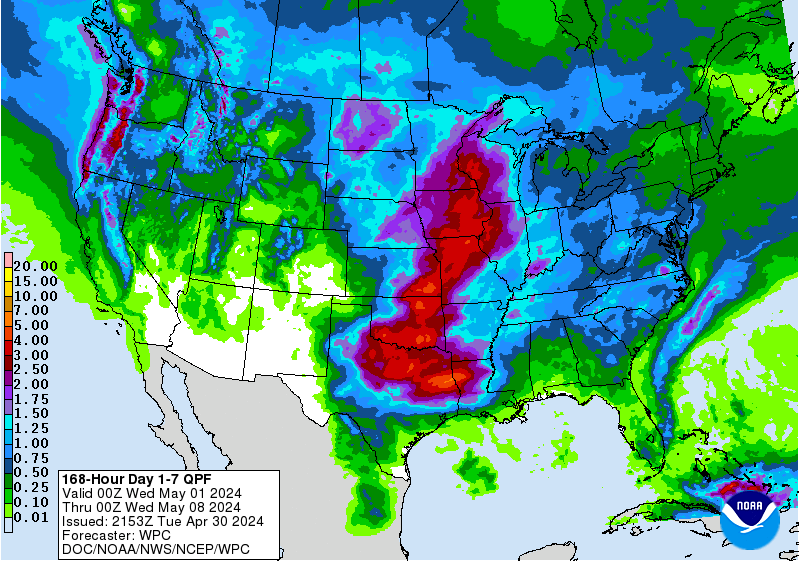
This looks really good, but I’m not sure what their basing their forecast off of? The GFS only shows 1-2” of rain over the next two weeks on average in the areas shaded in the darkest green. The CPC wasn’t even that bullish on rainfall during this last rainy period we had and we got a foot of rain here. So what the heck are they seeing?

And the WPC isn’t very aggressive on rainfall either, granted it’s only through 7 days, but still I don’t understand what the CPC is seeing.
And the WPC isn’t very aggressive on rainfall either, granted it’s only through 7 days, but still I don’t understand what the CPC is seeing.
Last edited by Cpv17 on Mon Sep 17, 2018 3:42 pm, edited 1 time in total.
0 likes
-
CaptinCrunch

- S2K Supporter

- Posts: 8565
- Age: 56
- Joined: Mon Nov 03, 2003 4:33 pm
- Location: Lake Worth, TX (Tarrant Co.)
Re: Texas Fall 2018
Area Forecast Discussion
National Weather Service Fort Worth TX
322 PM CDT Mon Sep 17 2018
.LONG TERM...
/Tuesday through next Monday/
The southwest to northeast upper level pattern continues across
the country, placing North and Central Texas under a ridge of
high pressure that extends into the southeastern US. As we
continue through the week, an easterly wave is expected to
approach the region, leading to increased precipitation chances by
mid week. Slight warming trend is expected through Wednesday,
before increased cloud cover and humidity values lead to slightly
cooler temperatures. A cold front will be possible this weekend,
but confidence is low that it will make it into North Texas.
Tuesday and Wednesday
An upper level easterly wave will be moving into the Texas Gulf
Coast beginning Tuesday and continue into Wednesday. Normally,
this weak disturbance would lead to a northward push of afternoon
daytime sea breeze convection across Central and SE Texas. This,
however, appears to be limited on Tuesday due to the dry mid and
upper levels of the atmosphere. If anything was to develop, it
would be isolated showers and storms generally southeast of an
Athens to Hearne line. A bit more moisture is expected to make its
way northward on Wednesday east of Interstate 35, leading to a
slightly better chance for precipitation. The warmest temperatures
of the week can also be expected these days as little cloud cover
and slightly drier air allows for additional warming.
Temperatures are expected to be in the mid 90s across most of the
region, with low 90s in the far southwestern counties.
Thursday and Friday
By Thursday, a gradual pattern shift is expected to start taking
shape as a trough tries to dig a little deeper across the western
United States. This will in turn allow for a few shortwaves to
make their way into Texas, increasing the potential for showers
and storms. The first shortwave will emerge out of the Mexican
Plateau Thursday morning, then make its way into North and Central
Texas by the afternoon. Abundant moisture will be in place along
and east of Interstate 35, with PWs in excess of 1.5 inches. The
best timing for precipitation will likely be in the afternoon as
peak heating induces the necessary lift for convection. Convection
in the afternoon will likely remain limited to areas south of
Interstate 20. As we progress through the day, a slightly stronger
shortwave will move in from West Texas. Given it`s placement as
it approaches North and Central Texas, the highest rain chances
will be confined to areas west of a Jacksboro to Killeen line. By
Friday, the shortwave will be situated across North Texas into
Southern Oklahoma, providing sufficient large scale ascent for
scattered showers and a few thunderstorms throughout the day.
Moisture content will also be on the increase as PWs will likely
approach, if not slightly exceed 2 inches. Given the placement of
the shortwave and the northeastern movement, the highest rain
potential will be for areas along and north of Interstate 20. If
later guidance suggest a southward shift in the track, the bulk of
the precipitation may shift southward.
Saturday and Sunday
Abundant moisture will remain in place through the weekend, with
a continuation of showers and isolated storms on Saturday. Latest
guidance continues to disagree on a possible cold front making its
way as far south of North Texas. The operational GFS stalls the
cold front north of the Red River, with no additional upper level
support for southward movement. The ECMWF, however, develops a
surface low across Oklahoma during the day on Saturday and pushes
a cold front as far south of the I-20 corridor. Given confidence
is low on whether or not a cold front will make it this far south,
the forecast will represent continued southerly winds through the
duration of the weekend and into next week. Precipitation chances
will decrease on Sunday as the shortwave pulls away from the
region. If a boundary manages to stall across the region,
additional rain will be possible, mainly along and north of I-20.
With the start of the new week, precipitation chances will
decrease and temperatures are expected to remain in the upper 80s
across the region. Given the uncertainty in the weekend`s
forecast, confidence in Monday`s forecast is low. For now, will
advertise low PoPs given the possibility of a stalled boundary
somewhere north of I-20.
Hernandez
0 likes
-
bubba hotep

- S2K Supporter
- Posts: 5453
- Joined: Wed Dec 28, 2016 1:00 am
- Location: Collin County Texas
Re: Texas Fall 2018
Euro Weeklies look good all the way into the 1st of November. Also, it looks like there could be some early season snowstorms on the Front Range, thinking about heading up that way for Thanksgiving.
2 likes
Winter time post are almost exclusively focused on the DFW area.
-
bubba hotep
- S2K Supporter
- Posts: 5453
- Joined: Wed Dec 28, 2016 1:00 am
- Location: Collin County Texas
Re: Texas Fall 2018
Cpv17 wrote:This looks really good, but I’m not sure what their basing their forecast off of? The GFS only shows 1-2” of rain over the next two weeks on average in the areas shaded in the darkest green. The CPC wasn’t even that bullish on rainfall during this last rainy period we had and we got a foot of rain here. So what the heck are they seeing?
http://www.cpc.ncep.noaa.gov/products/predictions/610day/610prcp.new.gif
And the WPC isn’t very aggressive on rainfall either, granted it’s only through 7 days, but still I don’t understand what the CPC is seeing.
https://www.wpc.ncep.noaa.gov/qpf/p168i.gif?1537216468
Both the GFS and Euro are showing the MJO amping up into 8/1 over the next 7 - 10 days. That is a wet look for the Texas and there was just a big SOI drop. Sometimes you just have to ignore the models.
3 likes
Winter time post are almost exclusively focused on the DFW area.
-
Brent
- S2K Supporter
- Posts: 37086
- Age: 35
- Joined: Sun May 16, 2004 10:30 pm
- Location: Tulsa Oklahoma
- Contact:
Re: Texas Fall 2018
This heat cant end soon enough so over it its like really now
2 likes
#neversummer

Re: Texas Fall 2018
18z GFS had a pretty good front range cold front diving south into Texas. Chilly air mass for the season, Euro has been spitting it out on and off. Hopefully a sign of something.
2 likes
The above post and any post by Ntxw is NOT an official forecast and should not be used as such. It is just the opinion of the poster and may or may not be backed by sound meteorological data. It is NOT endorsed by any professional institution including Storm2k. For official information, please refer to NWS products.
Help support Storm2K!
-
Haris
- Category 5
- Posts: 1808
- Joined: Mon Nov 27, 2017 8:19 pm
- Location: ( Bee Cave) West Austin, Texas
Re: Texas Fall 2018
0z gfs is awesome !! 
2 likes
Weather geek and a storm spotter in West Austin. Not a degreed meteorologist. Big snow fan. Love rain and cold! Despise heat!

-
South Texas Storms

- Professional-Met

- Posts: 4002
- Joined: Thu Jun 24, 2010 12:28 am
- Location: Houston, TX
Re: Texas Fall 2018
After a few dry days, a wet weather pattern will likely be returning to much of the state Thursday through the weekend. A weak cold front is forecast to stall across central portions of Texas and combine with tropical moisture leading to a risk of heavy rain and flash flooding. We could see rainfall totals average around 1-3 inches, with locally higher amounts possible by Sunday night.
Of note, San Antonio International Airport has received over 14 inches of rain so far this month. If the airport receives an additional 2 inches of rain over the next 12 days, we will set a new September rainfall record!

Of note, San Antonio International Airport has received over 14 inches of rain so far this month. If the airport receives an additional 2 inches of rain over the next 12 days, we will set a new September rainfall record!
4 likes
-
Ralph's Weather
- S2K Supporter
- Posts: 2968
- Age: 36
- Joined: Fri Dec 13, 2013 11:55 am
- Location: Lindale, TX
Re: Texas Fall 2018
06Z GFS showing Fall hits right around the beginning of Oct.
3 likes
Follow on Facebook at Ralph's Weather.
-
Haris
- Category 5
- Posts: 1808
- Joined: Mon Nov 27, 2017 8:19 pm
- Location: ( Bee Cave) West Austin, Texas
Re: Texas Fall 2018
The active September continues .
Today’s afternoon models point to a large swath of 1-3” across most of Texas ; even higher near Dallas .
Likely more rain towards the end of the month from the bigger cold front if it occurs .
Likely will end up as the wettest September on record for much of South and Central Texas
Today’s afternoon models point to a large swath of 1-3” across most of Texas ; even higher near Dallas .
Likely more rain towards the end of the month from the bigger cold front if it occurs .
Likely will end up as the wettest September on record for much of South and Central Texas
2 likes
Weather geek and a storm spotter in West Austin. Not a degreed meteorologist. Big snow fan. Love rain and cold! Despise heat!
-
weatherdude1108
- Category 5
- Posts: 4172
- Joined: Tue Dec 13, 2011 1:04 pm
- Location: Northwest Austin/Cedar Park, TX
Re: Texas Fall 2018
Haris wrote:The active September continues .
Today’s afternoon models point to a large swath of 1-3” across most of Texas ; even higher near Dallas .
Likely more rain towards the end of the month from the bigger cold front if it occurs .
Likely will end up as the wettest September on record for much of South and Central Texas
Awesome, considering September is the 2nd wettest month of the year climatologically. Says a lot!
1 likes
The preceding post is NOT an official forecast, and should not be used as such. It is only the opinion of the poster and may or may not be backed by sound meteorological data. It is NOT endorsed by any professional institution including storm2k.org. For Official Information please refer to the NHC and NWS products.
-
Brent
- S2K Supporter
- Posts: 37086
- Age: 35
- Joined: Sun May 16, 2004 10:30 pm
- Location: Tulsa Oklahoma
- Contact:
Re: Texas Fall 2018
The end is in sight to the heat on the GFS Euro GEFS and EPS today
Good agreement on mid to late next week
The CMC has 40s in Dallas at the end of the run
Good agreement on mid to late next week
The CMC has 40s in Dallas at the end of the run
2 likes
#neversummer
-
ThunderSleetDreams

- S2K Supporter
- Posts: 1398
- Age: 41
- Joined: Tue Dec 20, 2011 4:42 pm
- Location: S of Weimar, TX
Re: Texas Fall 2018
Brent wrote:The end is in sight to the heat on the GFS Euro GEFS and EPS today
Good agreement on mid to late next week
The CMC has 40s in Dallas at the end of the run
Oh my precious heart, be still!
2 likes
#NeverSummer
I hibernate when it gets above 75 degrees!
I hibernate when it gets above 75 degrees!
-
weatherdude1108
- Category 5
- Posts: 4172
- Joined: Tue Dec 13, 2011 1:04 pm
- Location: Northwest Austin/Cedar Park, TX
Re: Texas Fall 2018
Looks fairly active in this latest discussion.
000
FXUS64 KEWX 182003
AFDEWX
Area Forecast Discussion
National Weather Service Austin/San Antonio TX
303 PM CDT Tue Sep 18 2018
.SHORT TERM (Tonight through Wednesday Night)...
The latest water vapor imagery shows an upper low centered in the
northwest Gulf of Mexico, with broad cyclonic flow in the mid and upper
levels across roughly the southern half of Texas. In the low-
levels, weak high pressure was located over southeast Texas with
southerly winds in place across our region. Late afternoon
temperatures across the region were generally in the 80s with a few
readings in the lower 90s.
For the remainder of this afternoon and early evening, we will maintain
a low chance for convection along the Rio Grande. The latest hi-res
models are not very aggressive in coverage and will keep rain chances
limited to 20%. Most activity is expected to diminish with daytime
heating, although a few showers can`t be ruled out during the early
morning hours as the low-level jet strengthens. Elsewhere, look for a
rain-free forecast tonight with some patchy fog developing after
midnight along and east of the I-35/I-37 corridor. The coastal plains
will be favored for lower visibilities during the overnight hours
into early Wednesday morning as winds will be lightest here.
On Wednesday, the overall pattern will change little as the upper low
in the northwest Gulf drifts northward. We still expect some isolated
showers and thunderstorms to develop, mainly in the afternoon hours
along the Rio Grande. The latest suite of hi-res models do not show
much coverage of showers and storms and we will limit rain chances to
20%.
&&
.LONG TERM (Thursday through Tuesday)...
On Thursday, the weather pattern will begin to change as the subtropical
high shifts eastward and strengthens over the eastern U.S., while a
broad trough approaches from the west. The latest round of model data
continues to advertise a good chance of rain for south central Texas
during the latter half of the week. The remnants of a weak tropical
disturbance in the eastern Pacific are still not handled too well by
the models. However, it does appear we can expect some increase in
moisture from the Pacific along with southerly flow in the lower and
mid-levels, leading to increasing moisture from the Gulf of Mexico.
Rain chances on Thursday will initially be favored across the Rio
Grande plains where low-level upslope flow and a weak upper
disturbance moving in from the west will be found. As weak upper
disturbances continue to filter in from the west, rain chances will
spread eastward and increase on Friday and Saturday. The models
continue to show precipitation will be fairly widespread and have
also increased rainfall amounts in the latest MOS data. With a lack
of a well-defined surface feature, it will be difficult to pinpoint
which areas will see the heaviest rains as we head into late this
week and the upcoming weekend. For now, we have increased rain
chances across all areas on Friday and Saturday. If subsequent model
data remains consistent, we will need to increase the chance of rain
for all areas on Saturday, with the focus for rainfall expected to
shift eastward to along and east of the I-35 corridor on Sunday. We
have included the mention of locally heavy rainfall in the Hazardous
Weather Outlook for Thursday through the weekend.
For early next week, we should see a gradual decrease in rain chances
with only a very minimal decrease in moisture. Areas east of I-35
will remain favored for some afternoon seabreeze convection on Monday
and Tuesday. The medium range models also show potential for an
inverted trough moving in from the Gulf early next week, but differ
on the timing.
&&
1 likes
The preceding post is NOT an official forecast, and should not be used as such. It is only the opinion of the poster and may or may not be backed by sound meteorological data. It is NOT endorsed by any professional institution including storm2k.org. For Official Information please refer to the NHC and NWS products.

Re: Texas Fall 2018
Way out in lala land, GFS 300+ hours, there's a hurricane landfalling on the Baja peninsula (CAT 5 IN THE GULF [of california] !!!), then traversing Mexico and coming in to the far Western parts of Texas, as a cold front approaches. So it's probably not going to happen, but worth noting.
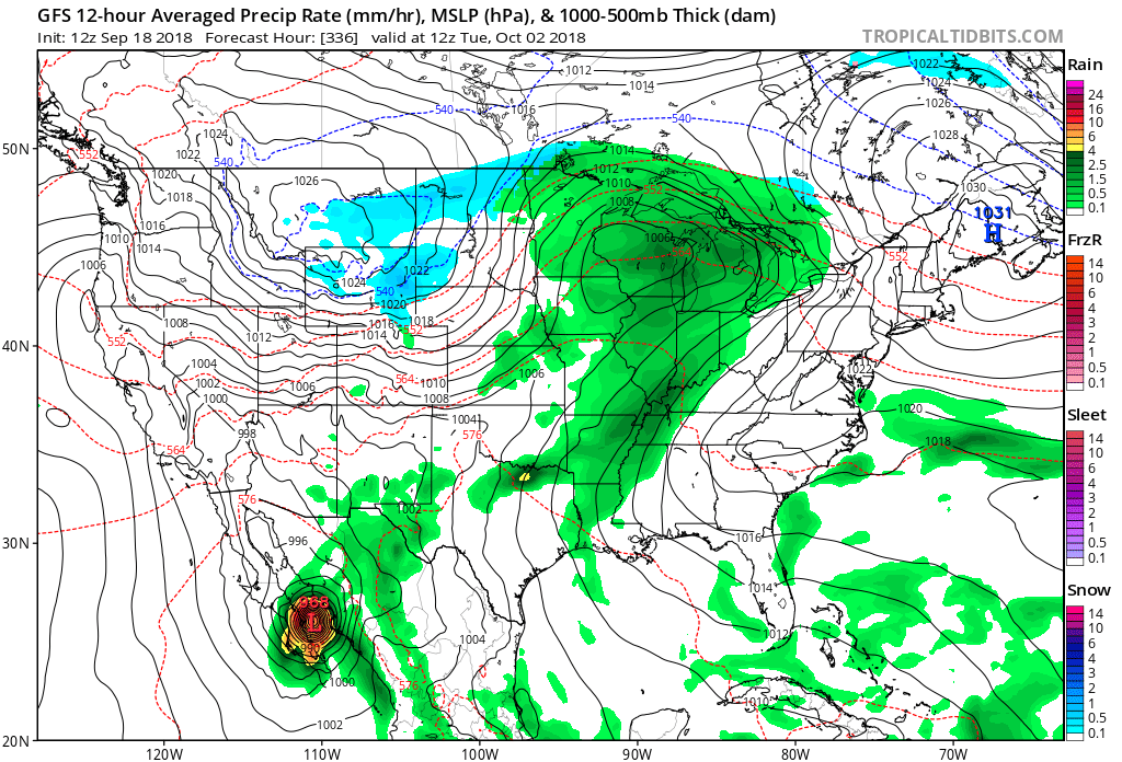
edit - added image
edit - added image
1 likes
The above post and any post by dhweather is NOT an official forecast and should not be used as such. It is just the opinion of the poster and may or may not be backed by sound meteorological data. It is NOT endorsed by any professional institution including storm2k.org. For official information, please refer to NWS products.
-
ThunderSleetDreams
- S2K Supporter
- Posts: 1398
- Age: 41
- Joined: Tue Dec 20, 2011 4:42 pm
- Location: S of Weimar, TX
Re: Texas Fall 2018
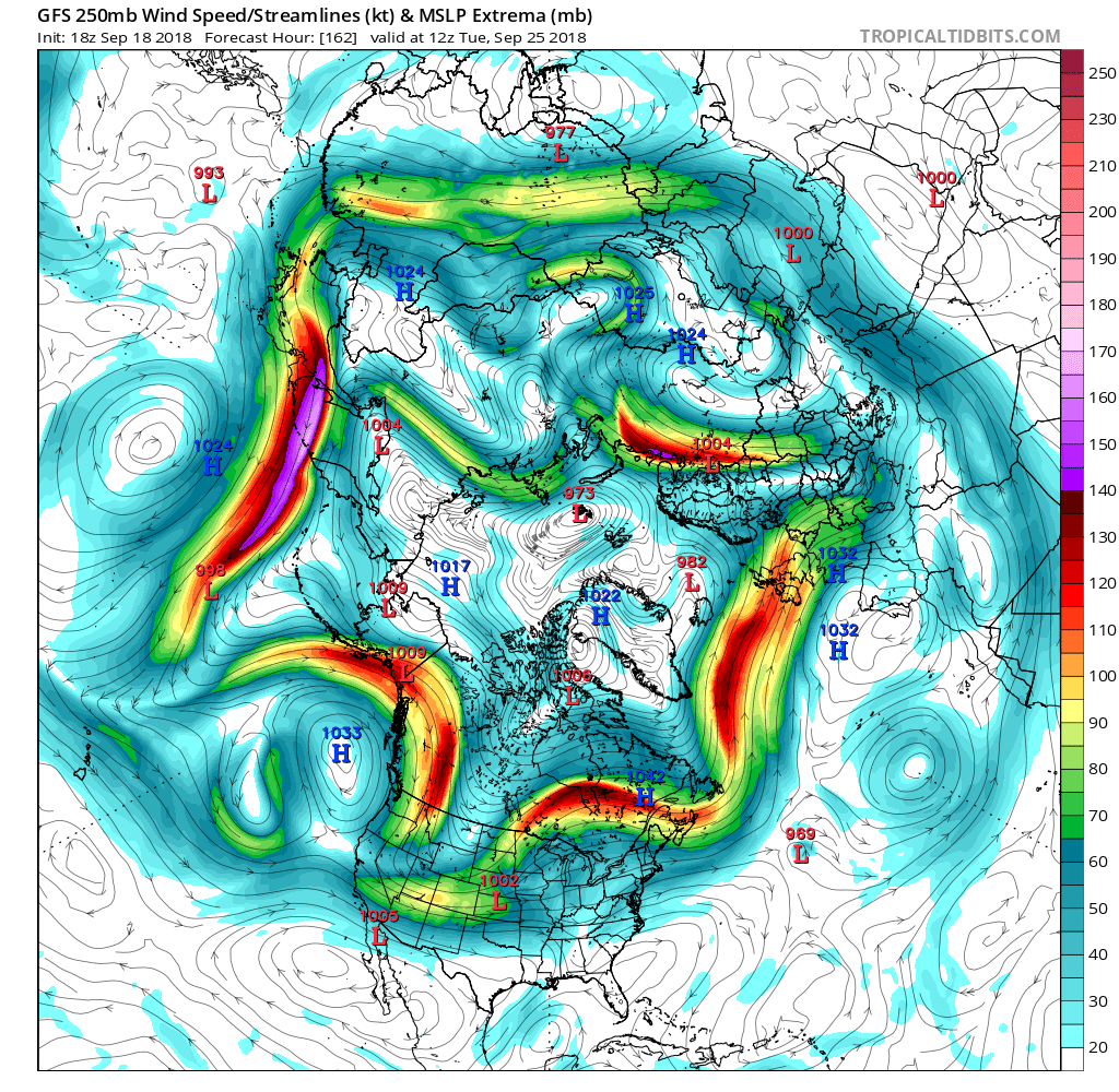
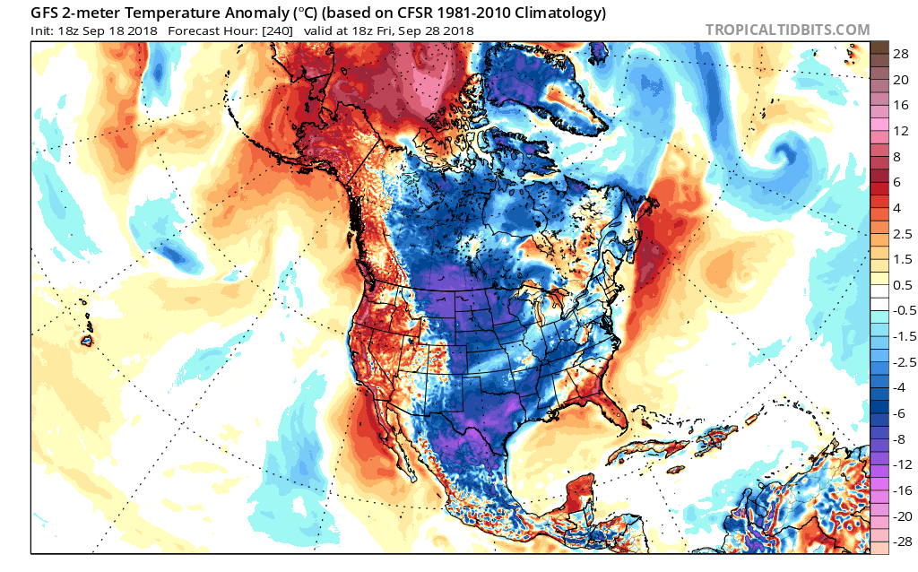
I LOVE SEEING BLUE ON THE MAP, ALBEIT UPSTREAM!
2 likes
#NeverSummer
I hibernate when it gets above 75 degrees!
I hibernate when it gets above 75 degrees!
Re: Texas Fall 2018
ThunderSleetDreams wrote:I LOVE SEEING BLUE ON THE MAP, ALBEIT UPSTREAM!
It is nice to see the blue on an early October map, laying down that foundation we will need for our cold in a couple months. It is coming folks, just gotta wait. Oh, by the way it is currently 93 degrees with awful humidity.
1 likes
Re: Texas Fall 2018
The East Asian/Pacific jet extension is going to occur in the coming week. This will buckle the North Pacific pattern into a -EPO configuration over the Northeast Pacific and NW North America (big ridge). We are familiar with this sight as it portrays cold building over Canada first and eventually spilling into the US. Likely the first real Fall front is imminent on the horizon. We will also lay down some early snow cover over Canada.
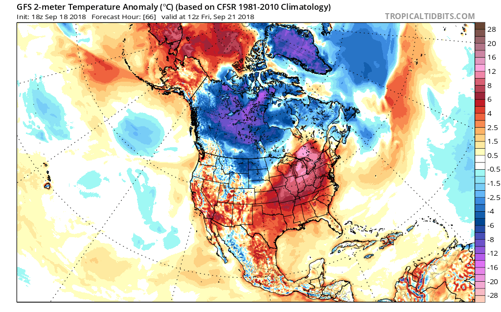
We have waited almost 5 months for this.
We have waited almost 5 months for this.
4 likes
The above post and any post by Ntxw is NOT an official forecast and should not be used as such. It is just the opinion of the poster and may or may not be backed by sound meteorological data. It is NOT endorsed by any professional institution including Storm2k. For official information, please refer to NWS products.
Help support Storm2K!
Help support Storm2K!
Return to “USA & Caribbean Weather”
Who is online
Users browsing this forum: No registered users and 31 guests