Texas Fall 2018

U.S. & Caribbean Weather Discussions and Severe Weather Events

Moderator: S2k Moderators

Forum rules

The posts in this forum are NOT official forecast and should not be used as such. They are just the opinion of the poster and may or may not be backed by sound meteorological data. They are NOT endorsed by any professional institution or STORM2K.

Help Support Storm2K
Message
Author
weatherdude1108
Category 5
Category 5
Posts: 4172
Joined: Tue Dec 13, 2011 1:04 pm
Location: Northwest Austin/Cedar Park, TX

Re: Texas Fall 2018

#961 Postby weatherdude1108 » Thu Oct 18, 2018 8:10 am

Crazy to think how much the lakes have risen in 7 days/30 days.

Travis has risen 36 feet, in 7 days time!

Image
1 likes   
The preceding post is NOT an official forecast, and should not be used as such. It is only the opinion of the poster and may or may not be backed by sound meteorological data. It is NOT endorsed by any professional institution including storm2k.org. For Official Information please refer to the NHC and NWS products.

Ntxw
Storm2k Moderator
Storm2k Moderator
Posts: 21501
Joined: Wed Oct 21, 2009 6:34 pm
Location: DFW, Texas

Re: Texas Fall 2018

#962 Postby Ntxw » Thu Oct 18, 2018 8:12 am

06z GFS rainfall. This is your classic Textbook epac October Mexican hit then flood. Look for WPC maps to light up by early next week and more flood watches.

This could be a big one Vicente

Image
1 likes   
The above post and any post by Ntxw is NOT an official forecast and should not be used as such. It is just the opinion of the poster and may or may not be backed by sound meteorological data. It is NOT endorsed by any professional institution including Storm2k. For official information, please refer to NWS products.

  Help support Storm2K!
Help Support Storm2K

weatherdude1108
Category 5
Category 5
Posts: 4172
Joined: Tue Dec 13, 2011 1:04 pm
Location: Northwest Austin/Cedar Park, TX

Re: Texas Fall 2018

#963 Postby weatherdude1108 » Thu Oct 18, 2018 8:29 am

My dad just texted me saying that he just heard Al Roker talking about Lake Travis on TODAY.
0 likes   
The preceding post is NOT an official forecast, and should not be used as such. It is only the opinion of the poster and may or may not be backed by sound meteorological data. It is NOT endorsed by any professional institution including storm2k.org. For Official Information please refer to the NHC and NWS products.

User avatar
gboudx
S2K Supporter
S2K Supporter
Posts: 4047
Joined: Thu Sep 04, 2003 1:39 pm
Location: Rockwall, Tx but from Harvey, La

Re: Texas Fall 2018

#964 Postby gboudx » Thu Oct 18, 2018 8:38 am

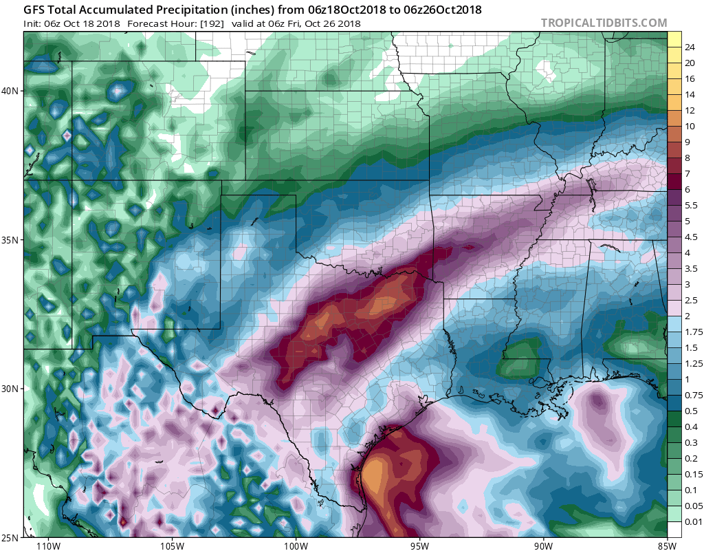
Ntxw wrote:06z GFS rainfall. This is your classic Textbook epac October Mexican hit then flood. Look for WPC maps to light up by early next week and more flood watches.

This could be a big one Vicente


Rockwall county is square in the middle of that 10-12" color. I hope that doesn't happen. Too much water.
0 likes   

User avatar
gboudx
S2K Supporter
S2K Supporter
Posts: 4047
Joined: Thu Sep 04, 2003 1:39 pm
Location: Rockwall, Tx but from Harvey, La

Re: Texas Fall 2018

#965 Postby gboudx » Thu Oct 18, 2018 9:46 am

Latest FWD drought map. Looks like we need to get the folks down in the Waco and Mexia areas a bit more rain.

Image

Statewide is just incredible how much drought has eased.

Image
1 likes   

User avatar
1900hurricane
Category 5
Category 5
Posts: 6044
Age: 32
Joined: Fri Feb 06, 2015 12:04 pm
Location: Houston, TX
Contact:

Re: Texas Fall 2018

#966 Postby 1900hurricane » Thu Oct 18, 2018 10:20 am

0 likes   
Contract Meteorologist. TAMU & MSST. Fiercely authentic, one of a kind. We are all given free will, so choose a life meant to be lived. We are the Masters of our own Stories.
Opinions expressed are mine alone.

Follow me on Twitter at @1900hurricane : Read blogs at https://1900hurricane.wordpress.com/

weatherdude1108
Category 5
Category 5
Posts: 4172
Joined: Tue Dec 13, 2011 1:04 pm
Location: Northwest Austin/Cedar Park, TX

Re: Texas Fall 2018

#967 Postby weatherdude1108 » Thu Oct 18, 2018 10:23 am

Image

They're keeping Buchanan as close to 1018 as possible. Full is 1021, but they're making upgrades to it, and don't have much wiggle room for floods at 1021.
0 likes   
The preceding post is NOT an official forecast, and should not be used as such. It is only the opinion of the poster and may or may not be backed by sound meteorological data. It is NOT endorsed by any professional institution including storm2k.org. For Official Information please refer to the NHC and NWS products.

Brent
S2K Supporter
S2K Supporter
Posts: 37092
Age: 35
Joined: Sun May 16, 2004 10:30 pm
Location: Tulsa Oklahoma
Contact:

Re: Texas Fall 2018

#968 Postby Brent » Thu Oct 18, 2018 10:46 am

Anyone else have a strange brlght light in their yard right now? :lol:
1 likes   
#neversummer

Cpv17
Category 5
Category 5
Posts: 4319
Joined: Wed Dec 07, 2016 2:24 pm
Location: Wharton/El Campo, TX

Re: Texas Fall 2018

#969 Postby Cpv17 » Thu Oct 18, 2018 10:57 am

Ralph's Weather wrote:

I don't think they are that much of a contraction. The NW TX rain depends on the path of Vicente's moisture and the Gulf rain depends on the path of a Gulf low. It does not take much rain to get above average in W TX so any amount of rain out there puts them above average.


I was referring to the southeast lol the Euro is more in line with it though.
0 likes   

Cpv17
Category 5
Category 5
Posts: 4319
Joined: Wed Dec 07, 2016 2:24 pm
Location: Wharton/El Campo, TX

Re: Texas Fall 2018

#970 Postby Cpv17 » Thu Oct 18, 2018 11:36 am

The 12z GFS is way different with Vicente. Stays too close to the coastline to strengthen.
0 likes   

Ralph's Weather
S2K Supporter
S2K Supporter
Posts: 2968
Age: 36
Joined: Fri Dec 13, 2013 11:55 am
Location: Lindale, TX

Re: Texas Fall 2018

#971 Postby Ralph's Weather » Thu Oct 18, 2018 11:41 am

Cpv17 wrote:The 12z GFS is way different with Vicente. Stays too close to the coastline to strengthen.

There was a run yesterday that showed that also I believe. 12Z GFS also has lost the -EPO through H220. With the very warm GoA I suspect the -EPO will return on future runs.
0 likes   
Follow on Facebook at Ralph's Weather.

Cpv17
Category 5
Category 5
Posts: 4319
Joined: Wed Dec 07, 2016 2:24 pm
Location: Wharton/El Campo, TX

Re: Texas Fall 2018

#972 Postby Cpv17 » Thu Oct 18, 2018 12:01 pm

Ralph's Weather wrote:
Cpv17 wrote:The 12z GFS is way different with Vicente. Stays too close to the coastline to strengthen.

There was a run yesterday that showed that also I believe. 12Z GFS also has lost the -EPO through H220. With the very warm GoA I suspect the -EPO will return on future runs.


I think the 12z GFS is drunk :lol:
0 likes   

Ralph's Weather
S2K Supporter
S2K Supporter
Posts: 2968
Age: 36
Joined: Fri Dec 13, 2013 11:55 am
Location: Lindale, TX

Re: Texas Fall 2018

#973 Postby Ralph's Weather » Thu Oct 18, 2018 12:51 pm

Cpv17 wrote:
Ralph's Weather wrote:
Cpv17 wrote:The 12z GFS is way different with Vicente. Stays too close to the coastline to strengthen.

There was a run yesterday that showed that also I believe. 12Z GFS also has lost the -EPO through H220. With the very warm GoA I suspect the -EPO will return on future runs.


I think the 12z GFS is drunk :lol:

Agreed, currently we are under a pretty strong upper ridge but because of -EPO we are cool. According to the 12Z GFS under a pretty strong trough we would be warm, odd. That run just seems off to me. It is just about a complete opposite of the 12Z GEFS also. THE GEFS, GEPS and EPS all generally show polar blocking and an eastern trough for late month at this range I would go with that.
0 likes   
Follow on Facebook at Ralph's Weather.

utpmg
S2K Supporter
S2K Supporter
Posts: 172
Age: 65
Joined: Thu Jan 03, 2013 12:07 am
Location: East Austin

Re: Texas Fall 2018

#974 Postby utpmg » Thu Oct 18, 2018 1:44 pm

Hmm, I was looking again at the list of historical Lake Travis "crests" from the NWS page: https://water.weather.gov/ahps2/crests. ... e=historic
Historic Crests
(1) 710.44 ft on 12/25/1991
(2) 707.38 ft on 05/18/1957
(3) 705.11 ft on 07/07/1997
(4) 704.68 ft on 02/10/1992
(5) 701.50 ft on 07/06/2007
(6) 696.70 ft on 11/24/2004
(7) 693.50 ft on 07/07/2002
(8) 693.48 ft on 10/14/1987
(9) 692.69 ft on 06/07/2016
(10) 692.58 ft on 10/07/1959
(11) 692.42 ft on 04/18/1977
(12) 688.13 ft on 03/20/1998
(13) 687.29 ft on 02/22/1997

...and those numbers seem incomplete. There was a period of 692' in early 1968 that doesn't show up; it's on the LCRA dataset. (And I have a photo from that time, too.)
1 likes   

User avatar
cheezyWXguy
Category 5
Category 5
Posts: 5528
Joined: Mon Feb 13, 2006 12:29 am
Location: Dallas, TX

Re: Texas Fall 2018

#975 Postby cheezyWXguy » Thu Oct 18, 2018 2:20 pm

Cpv17 wrote:
Ralph's Weather wrote:
Cpv17 wrote:The 12z GFS is way different with Vicente. Stays too close to the coastline to strengthen.

There was a run yesterday that showed that also I believe. 12Z GFS also has lost the -EPO through H220. With the very warm GoA I suspect the -EPO will return on future runs.


I think the 12z GFS is drunk :lol:

Agreed. It actually does develop it into the 970s, grazes it along the coastline shortly after. I think the GFS is developing the circulation too far west. It shows consolidation south of the Gulf of Tehuantepec, but visible satellite suggests the circulation is quickly consolidating south of Guatemala. This may result a path that takes future Vicente further away from the Mexican coast
0 likes   

Cpv17
Category 5
Category 5
Posts: 4319
Joined: Wed Dec 07, 2016 2:24 pm
Location: Wharton/El Campo, TX

Re: Texas Fall 2018

#976 Postby Cpv17 » Thu Oct 18, 2018 2:23 pm

The Euro has widespread 2-3” for a good part of the state with some isolated 4-6” totals. Not too bad. I’ll take it!
1 likes   

User avatar
Haris
Category 5
Category 5
Posts: 1808
Joined: Mon Nov 27, 2017 8:19 pm
Location: ( Bee Cave) West Austin, Texas

Re: Texas Fall 2018

#977 Postby Haris » Thu Oct 18, 2018 2:40 pm

Cpv17 wrote:The Euro has widespread 2-3” for a good part of the state with some isolated 4-6” totals. Not too bad. I’ll take it!


Umm. We don’t need that here in Austin lol yet.

Wait 2 weeks :wink:

Waters still rising
1 likes   
Weather geek and a storm spotter in West Austin. Not a degreed meteorologist. Big snow fan. Love rain and cold! Despise heat!

Cpv17
Category 5
Category 5
Posts: 4319
Joined: Wed Dec 07, 2016 2:24 pm
Location: Wharton/El Campo, TX

Re: Texas Fall 2018

#978 Postby Cpv17 » Thu Oct 18, 2018 2:55 pm

Haris wrote:
Cpv17 wrote:The Euro has widespread 2-3” for a good part of the state with some isolated 4-6” totals. Not too bad. I’ll take it!


Umm. We don’t need that here in Austin lol yet.

Wait 2 weeks :wink:

Waters still rising


Right! Lol but we need it here
0 likes   

weatherdude1108
Category 5
Category 5
Posts: 4172
Joined: Tue Dec 13, 2011 1:04 pm
Location: Northwest Austin/Cedar Park, TX

Re: Texas Fall 2018

#979 Postby weatherdude1108 » Thu Oct 18, 2018 3:23 pm

I've heard people around work, etc. talk about how "unprecedented" this flooding is.

But it's not unprecedented. It happened with a record crest on Travis the 1991. Granted there are more developments in and around all the lakes' floodplains now.

But that, in a nutshell, is asking for trouble. Either people know the flood risk and don't care, or are ignorant of the risk building in a 100, 500, or 1,000 year floodplain. Then when it floods, they're shocked.

We live in Flash Flood Alley. Anyway, rant over.lol
1 likes   
The preceding post is NOT an official forecast, and should not be used as such. It is only the opinion of the poster and may or may not be backed by sound meteorological data. It is NOT endorsed by any professional institution including storm2k.org. For Official Information please refer to the NHC and NWS products.

utpmg
S2K Supporter
S2K Supporter
Posts: 172
Age: 65
Joined: Thu Jan 03, 2013 12:07 am
Location: East Austin

Re: Texas Fall 2018

#980 Postby utpmg » Thu Oct 18, 2018 4:32 pm

I haven't heard anyone who's been around here as long as I have call it "unprecedented." My family has certainly seen it this high a few times in the past. But I believe they've only recently redefined some of the flood plain scenarios. Specifically, the possible height over the spillway the water could be.
0 likes   


Return to “USA & Caribbean Weather”

Who is online

Users browsing this forum: Ntxw and 155 guests