Texas Fall 2018

U.S. & Caribbean Weather Discussions and Severe Weather Events

Moderator: S2k Moderators

Forum rules

The posts in this forum are NOT official forecast and should not be used as such. They are just the opinion of the poster and may or may not be backed by sound meteorological data. They are NOT endorsed by any professional institution or STORM2K.

Help Support Storm2K
Message
Author
Ntxw
Storm2k Moderator
Storm2k Moderator
Posts: 21501
Joined: Wed Oct 21, 2009 6:34 pm
Location: DFW, Texas

Re: Texas Fall 2018

#721 Postby Ntxw » Fri Oct 12, 2018 10:41 am

Haris wrote:NAM has a high of 43 in Austin !!!! :cold:


I think the NAM is a little extreme getting many into the 30s. While it is chilly in Canada I don't think it is cold enough for something that extreme. However having mid day highs in the 40s is easy because of the moderate rain projected keeping daytime heating nil and a strong north/northwest wind. It will be cold Monday and Tuesday. Near record cold for the dates.
2 likes   
The above post and any post by Ntxw is NOT an official forecast and should not be used as such. It is just the opinion of the poster and may or may not be backed by sound meteorological data. It is NOT endorsed by any professional institution including Storm2k. For official information, please refer to NWS products.

  Help support Storm2K!
Help Support Storm2K

User avatar
dhweather
S2K Supporter
S2K Supporter
Posts: 6163
Joined: Sat Aug 14, 2004 9:29 pm
Location: Heath, TX
Contact:

Re: Texas Fall 2018

#722 Postby dhweather » Fri Oct 12, 2018 11:18 am

12Z GFS rolling in, large parts of the metroplex getting 4+" of rain through Wednesday morning. Heaviest appears to be S/SW of the Metroplex.

Image
1 likes   
The above post and any post by dhweather is NOT an official forecast and should not be used as such. It is just the opinion of the poster and may or may not be backed by sound meteorological data. It is NOT endorsed by any professional institution including storm2k.org. For official information, please refer to NWS products.

weatherdude1108
Category 5
Category 5
Posts: 4172
Joined: Tue Dec 13, 2011 1:04 pm
Location: Northwest Austin/Cedar Park, TX

Re: Texas Fall 2018

#723 Postby weatherdude1108 » Fri Oct 12, 2018 11:53 am

dhweather wrote:12Z GFS rolling in, large parts of the metroplex getting 4+" of rain through Wednesday morning. Heaviest appears to be S/SW of the Metroplex.

http://i68.tinypic.com/f6vch.png


Part of that heaviest area looks like it is over the Lake Buchanan watershed.
0 likes   
The preceding post is NOT an official forecast, and should not be used as such. It is only the opinion of the poster and may or may not be backed by sound meteorological data. It is NOT endorsed by any professional institution including storm2k.org. For Official Information please refer to the NHC and NWS products.

User avatar
CaptinCrunch
S2K Supporter
S2K Supporter
Posts: 8574
Age: 56
Joined: Mon Nov 03, 2003 4:33 pm
Location: Lake Worth, TX (Tarrant Co.)

Re: Texas Fall 2018

#724 Postby CaptinCrunch » Fri Oct 12, 2018 12:10 pm

Ntxw wrote:
Haris wrote:NAM has a high of 43 in Austin !!!! :cold:


I think the NAM is a little extreme getting many into the 30s. While it is chilly in Canada I don't think it is cold enough for something that extreme. However having mid day highs in the 40s is easy because of the moderate rain projected keeping daytime heating nil and a strong north/northwest wind. It will be cold Monday and Tuesday. Near record cold for the dates.


Chilly for sure 48-53 for highs here in the DFW area. I sure hope the Rams @ Denver game is on TV this weekend. High of 27 and snow forecast for the game!! :ggreen: :ggreen:
0 likes   

User avatar
gboudx
S2K Supporter
S2K Supporter
Posts: 4047
Joined: Thu Sep 04, 2003 1:39 pm
Location: Rockwall, Tx but from Harvey, La

Re: Texas Fall 2018

#725 Postby gboudx » Fri Oct 12, 2018 1:08 pm

CaptinCrunch wrote:
Chilly for sure 48-53 for highs here in the DFW area. I sure hope the Rams @ Denver game is on TV this weekend. High of 27 and snow forecast for the game!! :ggreen: :ggreen:


It is on TV, but not in this area. I'll have it at my house since I have the NFL Sunday Ticket though.
2 likes   

gpsnowman
S2K Supporter
S2K Supporter
Posts: 2716
Joined: Fri Jan 07, 2011 10:35 am
Location: Grand Prairie Tx

Re: Texas Fall 2018

#726 Postby gpsnowman » Fri Oct 12, 2018 1:17 pm

gboudx wrote:
CaptinCrunch wrote:
Chilly for sure 48-53 for highs here in the DFW area. I sure hope the Rams @ Denver game is on TV this weekend. High of 27 and snow forecast for the game!! :ggreen: :ggreen:


It is on TV, but not in this area. I'll have it at my house since I have the NFL Sunday Ticket though.

Storm2k party in Rockwall on Sunday.
3 likes   

Ntxw
Storm2k Moderator
Storm2k Moderator
Posts: 21501
Joined: Wed Oct 21, 2009 6:34 pm
Location: DFW, Texas

Re: Texas Fall 2018

#727 Postby Ntxw » Fri Oct 12, 2018 1:25 pm

Models generally keep things below normal through the end of the month, even when the northern plains moderates. Very El Nino like weather pattern. Precursor of the months to come.
4 likes   
The above post and any post by Ntxw is NOT an official forecast and should not be used as such. It is just the opinion of the poster and may or may not be backed by sound meteorological data. It is NOT endorsed by any professional institution including Storm2k. For official information, please refer to NWS products.


  Help support Storm2K!

Help Support Storm2K


User avatar
gboudx
S2K Supporter
S2K Supporter
Posts: 4047
Joined: Thu Sep 04, 2003 1:39 pm
Location: Rockwall, Tx but from Harvey, La

Re: Texas Fall 2018

#728 Postby gboudx » Fri Oct 12, 2018 1:35 pm

gpsnowman wrote:
gboudx wrote:
CaptinCrunch wrote:
Chilly for sure 48-53 for highs here in the DFW area. I sure hope the Rams @ Denver game is on TV this weekend. High of 27 and snow forecast for the game!! :ggreen: :ggreen:


It is on TV, but not in this area. I'll have it at my house since I have the NFL Sunday Ticket though.

Storm2k party in Rockwall on Sunday.


LOL! I may even make chicken/sausage gumbo.
1 likes   

Cpv17
Category 5
Category 5
Posts: 4323
Joined: Wed Dec 07, 2016 2:24 pm
Location: Wharton/El Campo, TX

Re: Texas Fall 2018

#729 Postby Cpv17 » Fri Oct 12, 2018 1:46 pm

I have a question for anyone that can answer it, but I was just wondering what’s been keeping the heavier rains away from SETX? I’m not really complaining or anything, but it’s weird to me because usually we’re the wettest spot in the state. It seems like the Hill Country and up towards NTX has been getting most of the rain lately and that’s not usually a spot (especially the Hill Country) where it rains so much. Here where I live in Wharton we’ve only had about 2” of rain in the past month. Not to say that’s completely terrible, but other areas of the state have had significantly more than that.
0 likes   

Ntxw
Storm2k Moderator
Storm2k Moderator
Posts: 21501
Joined: Wed Oct 21, 2009 6:34 pm
Location: DFW, Texas

Re: Texas Fall 2018

#730 Postby Ntxw » Fri Oct 12, 2018 2:13 pm

Cpv17 wrote:I have a question for anyone that can answer it, but I was just wondering what’s been keeping the heavier rains away from SETX? I’m not really complaining or anything, but it’s weird to me because usually we’re the wettest spot in the state. It seems like the Hill Country and up towards NTX has been getting most of the rain lately and that’s not usually a spot (especially the Hill Country) where it rains so much. Here where I live in Wharton we’ve only had about 2” of rain in the past month. Not to say that’s completely terrible, but other areas of the state have had significantly more than that.


It is probably more complex than this but SE Texas benefits most when the western gulf is active with tropical activity like what happened mid to late summer. Houston has seen some decent rains it's just I think you are sitting it a bad luck donut perhaps. It will improve though with El Nino, we'll see some gulf lows this winter causing mischief for SE Texas with El Nino. The past few weeks to a couple of months the EPAC has been funneling in moisture from both tropical systems and a subtropical jet connected to the deep Pacific tropics. This kind of flow benefits the inland empires more I think.

You can see below 2 things. The flare up of tropical convection right above the El Nino box. Secondly the remnants of Sergio making pass from the Baja. Both GFS and Euro develops another strong Hurricane southwest of the Mexican coast that eventually will re curve. So Sergio may not be the only October rain event.

Image
1 likes   
The above post and any post by Ntxw is NOT an official forecast and should not be used as such. It is just the opinion of the poster and may or may not be backed by sound meteorological data. It is NOT endorsed by any professional institution including Storm2k. For official information, please refer to NWS products.


  Help support Storm2K!

Help Support Storm2K


Ntxw
Storm2k Moderator
Storm2k Moderator
Posts: 21501
Joined: Wed Oct 21, 2009 6:34 pm
Location: DFW, Texas

Re: Texas Fall 2018

#731 Postby Ntxw » Fri Oct 12, 2018 2:27 pm

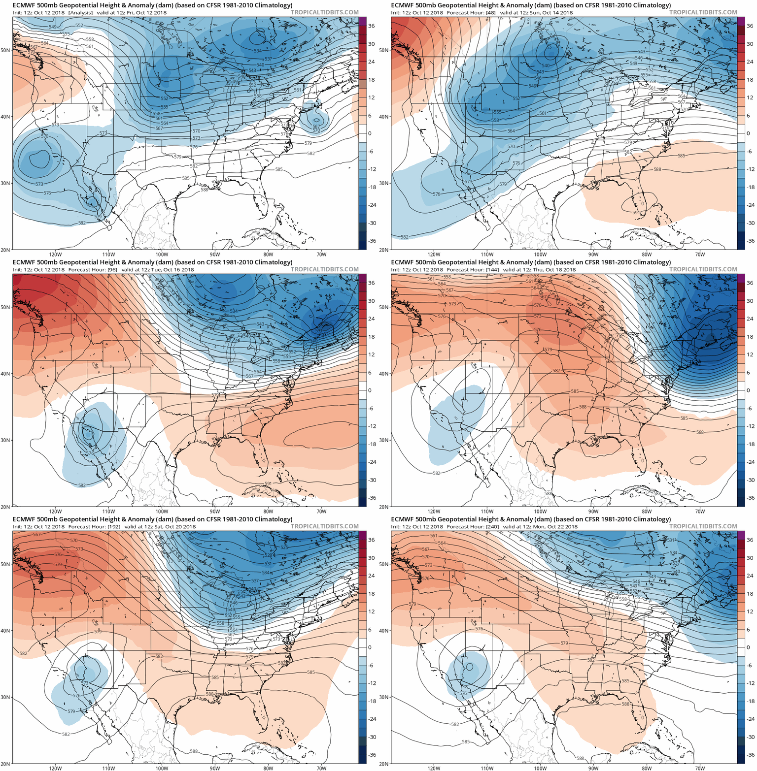
At 500mb the feature to watch is the persistence of the southwest/baja trough. This feature is a strong anomaly during weak and moderate El Ninos. It is the secret sauce to winter if it persists.

Image
1 likes   
The above post and any post by Ntxw is NOT an official forecast and should not be used as such. It is just the opinion of the poster and may or may not be backed by sound meteorological data. It is NOT endorsed by any professional institution including Storm2k. For official information, please refer to NWS products.


  Help support Storm2K!

Help Support Storm2K


weatherdude1108
Category 5
Category 5
Posts: 4172
Joined: Tue Dec 13, 2011 1:04 pm
Location: Northwest Austin/Cedar Park, TX

Re: Texas Fall 2018

#732 Postby weatherdude1108 » Fri Oct 12, 2018 2:32 pm

Cpv17 wrote:I have a question for anyone that can answer it, but I was just wondering what’s been keeping the heavier rains away from SETX? I’m not really complaining or anything, but it’s weird to me because usually we’re the wettest spot in the state. It seems like the Hill Country and up towards NTX has been getting most of the rain lately and that’s not usually a spot (especially the Hill Country) where it rains so much. Here where I live in Wharton we’ve only had about 2” of rain in the past month. Not to say that’s completely terrible, but other areas of the state have had significantly more than that.


That is interesting. Not sure how to answer this one(?). A pro met may need chime in. I'm guessing it's how the weather patterns have been traversing across the state, but not sure of the "why" part of it.

All I know is my backyard is just now starting to not feel like squishy PlayDoh when walking on it, after three days of dry-out time.
0 likes   
The preceding post is NOT an official forecast, and should not be used as such. It is only the opinion of the poster and may or may not be backed by sound meteorological data. It is NOT endorsed by any professional institution including storm2k.org. For Official Information please refer to the NHC and NWS products.

Brent
S2K Supporter
S2K Supporter
Posts: 37098
Age: 35
Joined: Sun May 16, 2004 10:30 pm
Location: Tulsa Oklahoma
Contact:

Re: Texas Fall 2018

#733 Postby Brent » Fri Oct 12, 2018 2:34 pm

its crazy looking at the models here in Mid October with all this rain and much below normal temperatures and in every previous year since 2014 we were looking at record heat around this time... :double:

I really hope this is a sign of things to come
1 likes   
#neversummer

Cpv17
Category 5
Category 5
Posts: 4323
Joined: Wed Dec 07, 2016 2:24 pm
Location: Wharton/El Campo, TX

Re: Texas Fall 2018

#734 Postby Cpv17 » Fri Oct 12, 2018 2:35 pm

Ntxw wrote:
Cpv17 wrote:I have a question for anyone that can answer it, but I was just wondering what’s been keeping the heavier rains away from SETX? I’m not really complaining or anything, but it’s weird to me because usually we’re the wettest spot in the state. It seems like the Hill Country and up towards NTX has been getting most of the rain lately and that’s not usually a spot (especially the Hill Country) where it rains so much. Here where I live in Wharton we’ve only had about 2” of rain in the past month. Not to say that’s completely terrible, but other areas of the state have had significantly more than that.


It is probably more complex than this but SE Texas benefits most when the western gulf is active with tropical activity like what happened mid to late summer. Houston has seen some decent rains it's just I think you are sitting it a bad luck donut perhaps. It will improve though with El Nino, we'll see some gulf lows this winter causing mischief for SE Texas with El Nino. The past few weeks to a couple of months the EPAC has been funneling in moisture from both tropical systems and a subtropical jet connected to the deep Pacific tropics. This kind of flow benefits the inland empires more I think.

You can see below 2 things. The flare up of tropical convection right above the El Nino box. Secondly the remnants of Sergio making pass from the Baja. Both GFS and Euro develops another strong Hurricane southwest of the Mexican coast that eventually will re curve. So Sergio may not be the only October rain event.

https://images2.imgbox.com/30/7d/qzsYHH6M_o.gif


Thanks for your input.
0 likes   

User avatar
Haris
Category 5
Category 5
Posts: 1808
Joined: Mon Nov 27, 2017 8:19 pm
Location: ( Bee Cave) West Austin, Texas

Re: Texas Fall 2018

#735 Postby Haris » Fri Oct 12, 2018 2:36 pm

It’s partially because SE TX is closer to the stubborn H pressure ridge over the SE the last few weeks.

*I think*
3 likes   
Weather geek and a storm spotter in West Austin. Not a degreed meteorologist. Big snow fan. Love rain and cold! Despise heat!

Brent
S2K Supporter
S2K Supporter
Posts: 37098
Age: 35
Joined: Sun May 16, 2004 10:30 pm
Location: Tulsa Oklahoma
Contact:

Re: Texas Fall 2018

#736 Postby Brent » Fri Oct 12, 2018 2:42 pm

Haris wrote:It’s partially because SE TX is closer to the stubborn H pressure ridge over the SE the last few weeks.

*I think*


I would definitely concur with that, fall has been non-existent in the SE until Michael and even now may not be there for good

Does make you wonder if there will be a battleground over TX if the pattern holds into the winter though
Last edited by Brent on Fri Oct 12, 2018 2:43 pm, edited 2 times in total.
2 likes   
#neversummer

User avatar
gboudx
S2K Supporter
S2K Supporter
Posts: 4047
Joined: Thu Sep 04, 2003 1:39 pm
Location: Rockwall, Tx but from Harvey, La

Re: Texas Fall 2018

#737 Postby gboudx » Fri Oct 12, 2018 2:42 pm

Ntxw wrote:At 500mb the feature to watch is the persistence of the southwest/baja trough. This feature is a strong anomaly during weak and moderate El Ninos. It is the secret sauce to winter if it persists.


Hopefully we see one of those events where an arctic front of sufficient depth pushes through, and disturbances pinwheel off the trough bringing precip to parts of Texas. Wintry precip goldmine.
3 likes   

Ntxw
Storm2k Moderator
Storm2k Moderator
Posts: 21501
Joined: Wed Oct 21, 2009 6:34 pm
Location: DFW, Texas

Re: Texas Fall 2018

#738 Postby Ntxw » Fri Oct 12, 2018 2:47 pm

gboudx wrote:
Ntxw wrote:At 500mb the feature to watch is the persistence of the southwest/baja trough. This feature is a strong anomaly during weak and moderate El Ninos. It is the secret sauce to winter if it persists.


Hopefully we see one of those events where an arctic front of sufficient depth pushes through, and disturbances pinwheel off the trough bringing precip to parts of Texas. Wintry precip goldmine.


There will be a lot of happy campers. This exact pattern, if this were 2 months down the road, would be a significant snow event.
4 likes   
The above post and any post by Ntxw is NOT an official forecast and should not be used as such. It is just the opinion of the poster and may or may not be backed by sound meteorological data. It is NOT endorsed by any professional institution including Storm2k. For official information, please refer to NWS products.


  Help support Storm2K!

Help Support Storm2K


Cpv17
Category 5
Category 5
Posts: 4323
Joined: Wed Dec 07, 2016 2:24 pm
Location: Wharton/El Campo, TX

Re: Texas Fall 2018

#739 Postby Cpv17 » Fri Oct 12, 2018 3:12 pm

Haris wrote:It’s partially because SE TX is closer to the stubborn H pressure ridge over the SE the last few weeks.

*I think*


This is what I was thinking too, but I like seeing different thoughts.
0 likes   

User avatar
bubba hotep
S2K Supporter
S2K Supporter
Posts: 5457
Joined: Wed Dec 28, 2016 1:00 am
Location: Collin County Texas

Re: Texas Fall 2018

#740 Postby bubba hotep » Fri Oct 12, 2018 3:15 pm

Flash Flood Watch hoisted for DFW:

URGENT - IMMEDIATE BROADCAST REQUESTED
Flood Watch
National Weather Service Fort Worth TX
312 PM CDT Fri Oct 12 2018

...FLASH FLOOD WATCH FOR PARTS OF NORTH TEXAS...

.A Flash Flood Watch is in effect from Midnight tonight until
6 AM Sunday for areas generally along and north of the Interstate
20 corridor.

Image
Last edited by bubba hotep on Fri Oct 12, 2018 3:18 pm, edited 1 time in total.
0 likes   
Winter time post are almost exclusively focused on the DFW area.


Return to “USA & Caribbean Weather”

Who is online

Users browsing this forum: Brent, CaptinCrunch, Cpv17, rwfromkansas and 160 guests