Texas Fall 2018
Moderator: S2k Moderators
Forum rules

The posts in this forum are NOT official forecast and should not be used as such. They are just the opinion of the poster and may or may not be backed by sound meteorological data. They are NOT endorsed by any professional institution or STORM2K.
-
gboudx

- S2K Supporter

- Posts: 4047
- Joined: Thu Sep 04, 2003 1:39 pm
- Location: Rockwall, Tx but from Harvey, La
Re: Texas Fall 2018
WFAA’s Colleen Coyle showed highs in the mid 70s next Thursday and Friday in the 6pm newscast. Please let her be right.
1 likes
-
Brent
- S2K Supporter
- Posts: 37094
- Age: 35
- Joined: Sun May 16, 2004 10:30 pm
- Location: Tulsa Oklahoma
- Contact:
Re: Texas Fall 2018
gboudx wrote:WFAA’s Colleen Coyle showed highs in the mid 70s next Thursday and Friday in the 6pm newscast. Please let her be right.
This is the best forecast ive seen in awhile too, please verify

1 likes
#neversummer

-
Brent
- S2K Supporter
- Posts: 37094
- Age: 35
- Joined: Sun May 16, 2004 10:30 pm
- Location: Tulsa Oklahoma
- Contact:
Re: Texas Fall 2018
0z Euro has 4 inches of rain for DFW(the weekend is basically a washout) and next Friday has a high in the... 60s...  .
.
.
2 likes
#neversummer

Re: Texas Fall 2018
Becoming real despite still some ways off. Today likely is the hottest day of the next 10 then we slowly stair step down. Next week will be gorgeous Fall weather.
3 likes
The above post and any post by Ntxw is NOT an official forecast and should not be used as such. It is just the opinion of the poster and may or may not be backed by sound meteorological data. It is NOT endorsed by any professional institution including Storm2k. For official information, please refer to NWS products.
Help support Storm2K!
Re: Texas Fall 2018
Also of note the rainfall chances this coming weekend is likely going to be enhanced by 94E in the Eastern Pacific currently over the Baja. It will fuse with some kind of front.
2 likes
The above post and any post by Ntxw is NOT an official forecast and should not be used as such. It is just the opinion of the poster and may or may not be backed by sound meteorological data. It is NOT endorsed by any professional institution including Storm2k. For official information, please refer to NWS products.
Help support Storm2K!
Help support Storm2K!
-
Haris

- Category 5

- Posts: 1808
- Joined: Mon Nov 27, 2017 8:19 pm
- Location: ( Bee Cave) West Austin, Texas
Re: Texas Fall 2018

Wow
3 likes
Weather geek and a storm spotter in West Austin. Not a degreed meteorologist. Big snow fan. Love rain and cold! Despise heat!
-
weatherdude1108
- Category 5
- Posts: 4172
- Joined: Tue Dec 13, 2011 1:04 pm
- Location: Northwest Austin/Cedar Park, TX
Re: Texas Fall 2018
Jim Spencer, the local weathercaster in Austin mentioned yesterday that the high was 95 at Camp Mabry ( I think 95?). He mentioned in passing that there's no reason for it to be 95 degrees after the inches of rain we received, and how it shows the effects of warming coming within a degree of the record, or something like that. Can't remember exactly what he said.
I was a little skeptical of what he mentioned, just because it seemed like he jumped to a conclusion based on the main-stream media bias towards warming. Not to say background warming isn't happening to an extent, but I was thinking in my head that Camp Mabry is surrounded by concrete in the area, especially the expanded Mopac thoroughfare, and if the wind blows right, that hotter air could hit the sensors and skew them towards a higher reading.
But playing the other side, I know Bergstrom was about the same temperature, and they tend to be cooler.
It could have been an odd day atmospherically(?). Not denying or playing alarmist, just thought it was an interesting blurb he decided to throw in there. So hard to figure out what's real and what's hyped anymore.
All I know is I'm looking forward to more rain!
1 likes
The preceding post is NOT an official forecast, and should not be used as such. It is only the opinion of the poster and may or may not be backed by sound meteorological data. It is NOT endorsed by any professional institution including storm2k.org. For Official Information please refer to the NHC and NWS products.
-
weatherdude1108
- Category 5
- Posts: 4172
- Joined: Tue Dec 13, 2011 1:04 pm
- Location: Northwest Austin/Cedar Park, TX
Re: Texas Fall 2018
325
FXUS64 KEWX 192003
AFDEWX
Area Forecast Discussion
National Weather Service Austin/San Antonio TX
303 PM CDT Wed Sep 19 2018
.SHORT TERM (Tonight through Thursday Night)...
The current mid to upper level pattern is characterized by broad
troughing across the western CONUS with a smaller shortwave trough in
the vicinity of Baja California with strong ridging across the
central CONUS. Today`s forecast is on track, with highs expected to
top out in the upper 80s to low 90s this afternoon. Moisture is on
the increase across the region, with source locations being both the
eastern Pacific as well as the Gulf of Mexico. Moistening across the
Rio Grande region tonight will yield a slight chance for showers and
thunderstorms. Otherwise, tonight will be mild with clouds on the
increase, moderating overnight lows.
PoPs will be on the increase for tomorrow as precipitable water
values increase further and weak upper level forcing from the
approaching troughs generates scattered showers and thunderstorms.
Models suggest the most favorable location for the possibility of
locally heavy rainfall will be along the Rio Grande and into the
southern Edwards Plateau region tomorrow afternoon and continuing
into the evening and overnight hours. High temperatures tomorrow
likely wont get out of the 80s with the cloud cover, increased
moisture, and the residual wet soils from the past two weeks of heavy
rain.
&&
.LONG TERM (Friday through Wednesday)...
Scattered to widespread showers and thunderstorms will continue for
Friday and Saturday, and these chances will spread north and eastward
to include all of South Central Texas. Given the very high
precipitable water values, tall and skinny CAPE profiles, and high
wet bulb zero values, locally heavy rainfall will be possible as
these showers/storms could be very efficient rain producers. With
the heavy rainfall that has impacted the region in the month of
September, there could be a localized flash flooding threat.
Rain chances will still exist for Sunday through Tuesday, but chances
will be lower than Friday and Saturday and the focus will shift more
toward the eastern half of the region. The locally heavy rainfall
threat will also diminish during this time period.
Models diverge a bit as we head into the end of the forecast period.
The GFS brings a strong cold front completely through the region
late Wednesday night into Thursday morning while the ECMWF shows the
front not coming through the region until late Thursday into Friday
morning. However, both models depict showers and thunderstorms along
and ahead of the frontal passage.
High temperatures for Friday through next Wednesday will be below
seasonal normals with not much diurnal range due to warmer overnight
temperatures due to persistent cloud cover and rain chances.
1 likes
The preceding post is NOT an official forecast, and should not be used as such. It is only the opinion of the poster and may or may not be backed by sound meteorological data. It is NOT endorsed by any professional institution including storm2k.org. For Official Information please refer to the NHC and NWS products.
-
weatherdude1108
- Category 5
- Posts: 4172
- Joined: Tue Dec 13, 2011 1:04 pm
- Location: Northwest Austin/Cedar Park, TX
Re: Texas Fall 2018


3 likes
The preceding post is NOT an official forecast, and should not be used as such. It is only the opinion of the poster and may or may not be backed by sound meteorological data. It is NOT endorsed by any professional institution including storm2k.org. For Official Information please refer to the NHC and NWS products.
-
bubba hotep

- S2K Supporter
- Posts: 5457
- Joined: Wed Dec 28, 2016 1:00 am
- Location: Collin County Texas
Re: Texas Fall 2018
12z Euro shows some crazy rain totals up along the Red River into S. Ok. What kind of an event would we be looking at if those 20"+ totals shifted south and verified in DFW?
2 likes
Winter time post are almost exclusively focused on the DFW area.
-
Brent
- S2K Supporter
- Posts: 37094
- Age: 35
- Joined: Sun May 16, 2004 10:30 pm
- Location: Tulsa Oklahoma
- Contact:
Re: Texas Fall 2018
bubba hotep wrote:12z Euro shows some crazy rain totals up along the Red River into S. Ok. What kind of an event would we be looking at if those 20"+ totals shifted south and verified in DFW?
I noticed that too
I wouldn't be at all surprised by flooding this weekend with the EPAC involved thats for sure, the models always struggle with heavy rain placement
0 likes
#neversummer
Re: Texas Fall 2018
Yeah don't be surprised if things shift around. Some crazy totals with now depression 19E.
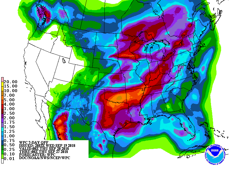
Coverage will be widespread given it is front+tropical system. Where front is dictates how much where.
Coverage will be widespread given it is front+tropical system. Where front is dictates how much where.
2 likes
The above post and any post by Ntxw is NOT an official forecast and should not be used as such. It is just the opinion of the poster and may or may not be backed by sound meteorological data. It is NOT endorsed by any professional institution including Storm2k. For official information, please refer to NWS products.
Help support Storm2K!
Help support Storm2K!
-
starsfan65

- Category 2

- Posts: 675
- Age: 46
- Joined: Thu Dec 17, 2015 1:18 pm
- Location: Garland,Tx
Re: Texas Fall 2018
5 inches of rain is enough!! Thank you!!bubba hotep wrote:12z Euro shows some crazy rain totals up along the Red River into S. Ok. What kind of an event would we be looking at if those 20"+ totals shifted south and verified in DFW?
0 likes
Re: Texas Fall 2018
18z GFS is way drier across Texas compared to previous runs. Probably doesn’t change anything though.


Last edited by Cpv17 on Wed Sep 19, 2018 6:25 pm, edited 2 times in total.
0 likes
-
starsfan65
- Category 2
- Posts: 675
- Age: 46
- Joined: Thu Dec 17, 2015 1:18 pm
- Location: Garland,Tx
Re: Texas Fall 2018
Cpv17 wrote:18z GFS is way drier across Texas compared to previous runs. Probably doesn’t change anything though.
The cold front could be sweeping through than stalling.
0 likes
Re: Texas Fall 2018
weatherdude1108 wrote:Jim Spencer, the local weathercaster in Austin mentioned yesterday that the high was 95 at Camp Mabry ( I think 95?). He mentioned in passing that there's no reason for it to be 95 degrees after the inches of rain we received, and how it shows the effects of warming coming within a degree of the record, or something like that. Can't remember exactly what he said.
I was a little skeptical of what he mentioned, just because it seemed like he jumped to a conclusion based on the main-stream media bias towards warming. Not to say background warming isn't happening to an extent, but I was thinking in my head that Camp Mabry is surrounded by concrete in the area, especially the expanded Mopac thoroughfare, and if the wind blows right, that hotter air could hit the sensors and skew them towards a higher reading.
But playing the other side, I know Bergstrom was about the same temperature, and they tend to be cooler.
It could have been an odd day atmospherically(?). Not denying or playing alarmist, just thought it was an interesting blurb he decided to throw in there. So hard to figure out what's real and what's hyped anymore.
All I know is I'm looking forward to more rain!
Surely the amount of pavement at Bergstrom dwarfs that near Mabry; also isn't the temperature station in the middle? Mabry is a pretty green area, like a big park. Bergstrom is surrounded by pavement.
0 likes
Re: Texas Fall 2018
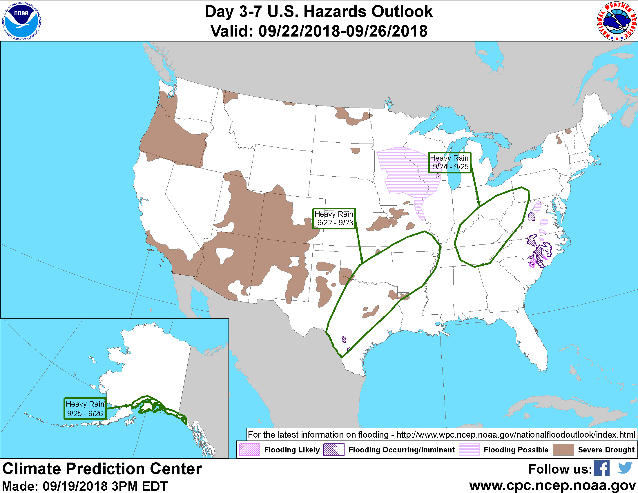
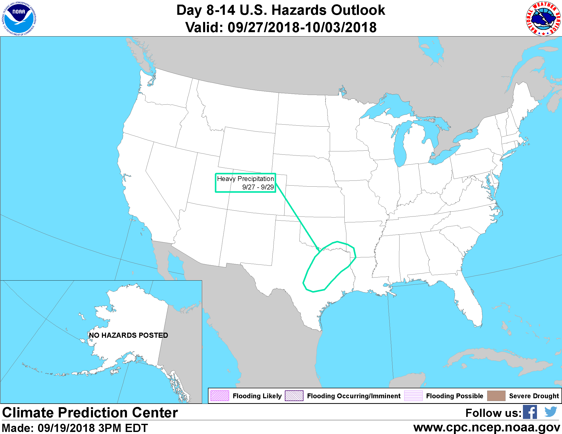
Risks from the CPC
1 likes
The above post and any post by Ntxw is NOT an official forecast and should not be used as such. It is just the opinion of the poster and may or may not be backed by sound meteorological data. It is NOT endorsed by any professional institution including Storm2k. For official information, please refer to NWS products.
Help support Storm2K!
Help support Storm2K!
Re: Texas Fall 2018
weatherdude1108 wrote:Jim Spencer, the local weathercaster in Austin mentioned yesterday that the high was 95 at Camp Mabry ( I think 95?). He mentioned in passing that there's no reason for it to be 95 degrees after the inches of rain we received, and how it shows the effects of warming coming within a degree of the record, or something like that. Can't remember exactly what he said.
I was a little skeptical of what he mentioned, just because it seemed like he jumped to a conclusion based on the main-stream media bias towards warming. Not to say background warming isn't happening to an extent, but I was thinking in my head that Camp Mabry is surrounded by concrete in the area, especially the expanded Mopac thoroughfare, and if the wind blows right, that hotter air could hit the sensors and skew them towards a higher reading.
But playing the other side, I know Bergstrom was about the same temperature, and they tend to be cooler.
It could have been an odd day atmospherically(?). Not denying or playing alarmist, just thought it was an interesting blurb he decided to throw in there. So hard to figure out what's real and what's hyped anymore.
All I know is I'm looking forward to more rain!
It's likely a combination of all the things you mentioned. Nothing is really isolated from one another. Background warming, urban sprawl, subsidence from Florence all conjoined. DFW for instance is seeing warmer overnight lows. The summer low this year was 86 which tied 2011 and it wasn't even nearly as hot a summer as that one. To get into the mid 80s in the past would take some incredible heat waves (such as 1980, 2011 etc) but now can happen any summer on just a regular heat wave. The warmest lows for DFW May-June-July-August have all occured since 2000. Most happening since 2010.
1 likes
The above post and any post by Ntxw is NOT an official forecast and should not be used as such. It is just the opinion of the poster and may or may not be backed by sound meteorological data. It is NOT endorsed by any professional institution including Storm2k. For official information, please refer to NWS products.
Help support Storm2K!
Help support Storm2K!
Return to “USA & Caribbean Weather”
Who is online
Users browsing this forum: AnnularCane and 142 guests