


Moderator: S2k Moderators


Cpv17 wrote:dhweather wrote:Crazy to think this is not a record flood on the Llano River.
https://water.weather.gov/resources/hydrographs/llat2_record.png
Historic Crests
(1) 41.50 ft on 06/14/1935
(2) 39.10 ft on 06/23/1997
(3) 32.60 ft on 09/10/1952
(4) 28.65 ft on 11/04/2000
(5) 22.07 ft on 11/17/2004
I agree with you. I can’t believe it’s not.

newtotex wrote:What does all of this mean for Austin?


weatherdude1108 wrote:Cpv17 wrote:dhweather wrote:Crazy to think this is not a record flood on the Llano River.
https://water.weather.gov/resources/hydrographs/llat2_record.png
Historic Crests
(1) 41.50 ft on 06/14/1935
(2) 39.10 ft on 06/23/1997
(3) 32.60 ft on 09/10/1952
(4) 28.65 ft on 11/04/2000
(5) 22.07 ft on 11/17/2004
I agree with you. I can’t believe it’s not.
Me neither. 1935 must have been a crazy event! That was during the Dust Bowl.
https://www.history.com/topics/great-de ... /dust-bowl


1900hurricane wrote:weatherdude1108 wrote:Cpv17 wrote:
I agree with you. I can’t believe it’s not.
Me neither. 1935 must have been a crazy event! That was during the Dust Bowl.
https://www.history.com/topics/great-de ... /dust-bowl
1935 was actually had a very wet spring across much of Texas. Much like this event, systems prior to the mid-June 1935 event resulted in saturated soil conditions across much of the Hill Country, leading to exceptionally efficient runoff. The 1930s in general featured several cases of some of the most extreme Hill Country flooding we've seen. 1932, 1935, 1936, and 1938 all had at least one huge flood.


bubba hotep wrote:Don't say you weren't warned...
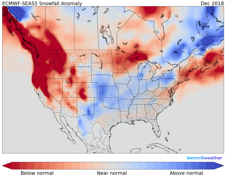
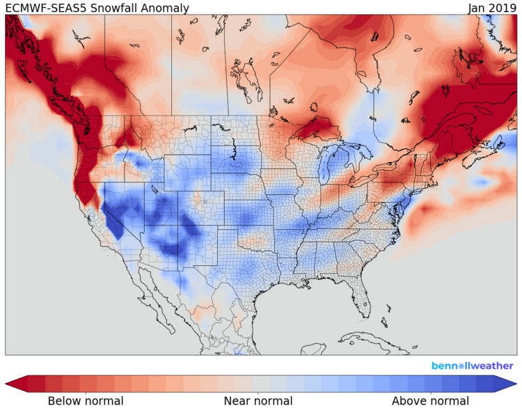
Euro Monthly Snowfall Anomalies
Dec
[https://static1.squarespace.com/static/5b09e7677c9327cbe42e65b5/t/5bc431334785d3ab4d009449/1539584318934/dec.png?format=750w
Jan
[https://static1.squarespace.com/static/5b09e7677c9327cbe42e65b5/t/5bc4314653450a5777e334d3/1539584337455/jan.png?format=750w
Feb
https://static1.squarespace.com/static/ ... ormat=750w
]https://j.gifs.com/wjzjEz.gif
Return to “USA & Caribbean Weather”
Users browsing this forum: No registered users and 68 guests

