Texas Spring 2019
Moderator: S2k Moderators
Forum rules

The posts in this forum are NOT official forecast and should not be used as such. They are just the opinion of the poster and may or may not be backed by sound meteorological data. They are NOT endorsed by any professional institution or STORM2K.
Re: Texas Spring 2019
Geez, the Euro still shows no signs of anything significant for the next 10 days  definitely nothing for the rest of the month.
0 likes
Re: Texas Spring 2019
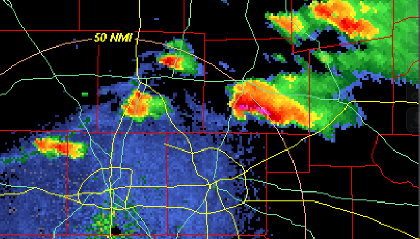
The storms up near Denton and McKinney just blew up. You can really see how tall the storms are from my perch in Irving.
2 likes
-
bubba hotep

- S2K Supporter

- Posts: 5457
- Joined: Wed Dec 28, 2016 1:00 am
- Location: Collin County Texas
Re: Texas Spring 2019
So far all the attempts south of 380 have failed. Looks like a cell is now trying to go up in SW Denton County?
0 likes
Winter time post are almost exclusively focused on the DFW area.

Re: Texas Spring 2019
Golfball hail moving into McKinney/Allen. $$$.
0 likes
The above post and any post by Ntxw is NOT an official forecast and should not be used as such. It is just the opinion of the poster and may or may not be backed by sound meteorological data. It is NOT endorsed by any professional institution including Storm2k. For official information, please refer to NWS products.
Help support Storm2K!
-
bubba hotep
- S2K Supporter
- Posts: 5457
- Joined: Wed Dec 28, 2016 1:00 am
- Location: Collin County Texas
Re: Texas Spring 2019
Ntxw wrote:Golfball hail moving into McKinney/Allen. $$$.
That cell is taking on a nasty look and hooking south. Good thing LCLs are really high today.

2 likes
Winter time post are almost exclusively focused on the DFW area.
Re: Texas Spring 2019
Baseball sized hail now. Allen, and parts of Wylie probably should have a heads up on this since it is making that turn.
Severe Weather Statement
National Weather Service Fort Worth TX
627 PM CDT SUN MAR 24 2019
TXC085-121-250015-
/O.CON.KFWD.SV.W.0036.000000T0000Z-190325T0015Z/
Denton TX-Collin TX-
627 PM CDT SUN MAR 24 2019
...A SEVERE THUNDERSTORM WARNING REMAINS IN EFFECT UNTIL 715 PM CDT
FOR EAST CENTRAL DENTON AND COLLIN COUNTIES...
At 626 PM CDT, a severe thunderstorm was located over Frisco, moving
east at 20 mph.
This is a very dangerous storm.
HAZARD...Baseball size hail and 65 mph wind gusts.
SOURCE...Radar indicated.
IMPACT...People and animals outdoors will be severely injured.
Expect shattered windows, extensive damage to roofs,
siding, and vehicles.
0 likes
The above post and any post by Ntxw is NOT an official forecast and should not be used as such. It is just the opinion of the poster and may or may not be backed by sound meteorological data. It is NOT endorsed by any professional institution including Storm2k. For official information, please refer to NWS products.
Help support Storm2K!
Help support Storm2K!
-
Haris

- Category 5

- Posts: 1808
- Joined: Mon Nov 27, 2017 8:19 pm
- Location: ( Bee Cave) West Austin, Texas
Re: Texas Spring 2019
Fairview: Hen egg size hail. Dont have pic. Report by a family member.
0 likes
Weather geek and a storm spotter in West Austin. Not a degreed meteorologist. Big snow fan. Love rain and cold! Despise heat!
Re: Texas Spring 2019
Severe Weather Statement
National Weather Service Fort Worth TX
644 PM CDT SUN MAR 24 2019
TXC085-250015-
/O.CON.KFWD.SV.W.0036.000000T0000Z-190325T0015Z/
Collin TX-
644 PM CDT SUN MAR 24 2019
...A SEVERE THUNDERSTORM WARNING REMAINS IN EFFECT UNTIL 715 PM CDT
FOR CENTRAL COLLIN COUNTY...
At 644 PM CDT, a severe thunderstorm was located over Allen, moving
east at 25 mph.
This is a very dangerous storm.
HAZARD...Baseball size hail and 65 mph wind gusts.
SOURCE...Radar indicated.
IMPACT...People and animals outdoors will be severely injured.
Expect shattered windows, extensive damage to roofs,
siding, and vehicles.
This severe storm will be near...
Fairview around 655 PM CDT.
Lucas and Lowry Crossing around 700 PM CDT.
Wylie around 710 PM CDT.
Other locations impacted by this severe thunderstorm include Melissa,
Westminster, Weston, Blue Ridge, New Hope, Josephine and Nevada.
PRECAUTIONARY/PREPAREDNESS ACTIONS...
This is a dangerous storm. Prepare immediately for large destructive
hail capable of producing significant damage. Move to a shelter,
inside a strong building and away from windows.
0 likes
The above post and any post by Ntxw is NOT an official forecast and should not be used as such. It is just the opinion of the poster and may or may not be backed by sound meteorological data. It is NOT endorsed by any professional institution including Storm2k. For official information, please refer to NWS products.
Help support Storm2K!
Help support Storm2K!

Re: Texas Spring 2019
Sirens were going off in Frisco for at least 10 minutes.
0 likes
Undergraduate Meteorology Student at the University of Oklahoma and Operator at the Oklahoma Mesonet.
All opinions independent of employers and the university.
All opinions independent of employers and the university.
-
bubba hotep
- S2K Supporter
- Posts: 5457
- Joined: Wed Dec 28, 2016 1:00 am
- Location: Collin County Texas


-
Haris
- Category 5
- Posts: 1808
- Joined: Mon Nov 27, 2017 8:19 pm
- Location: ( Bee Cave) West Austin, Texas
Re: Texas Spring 2019
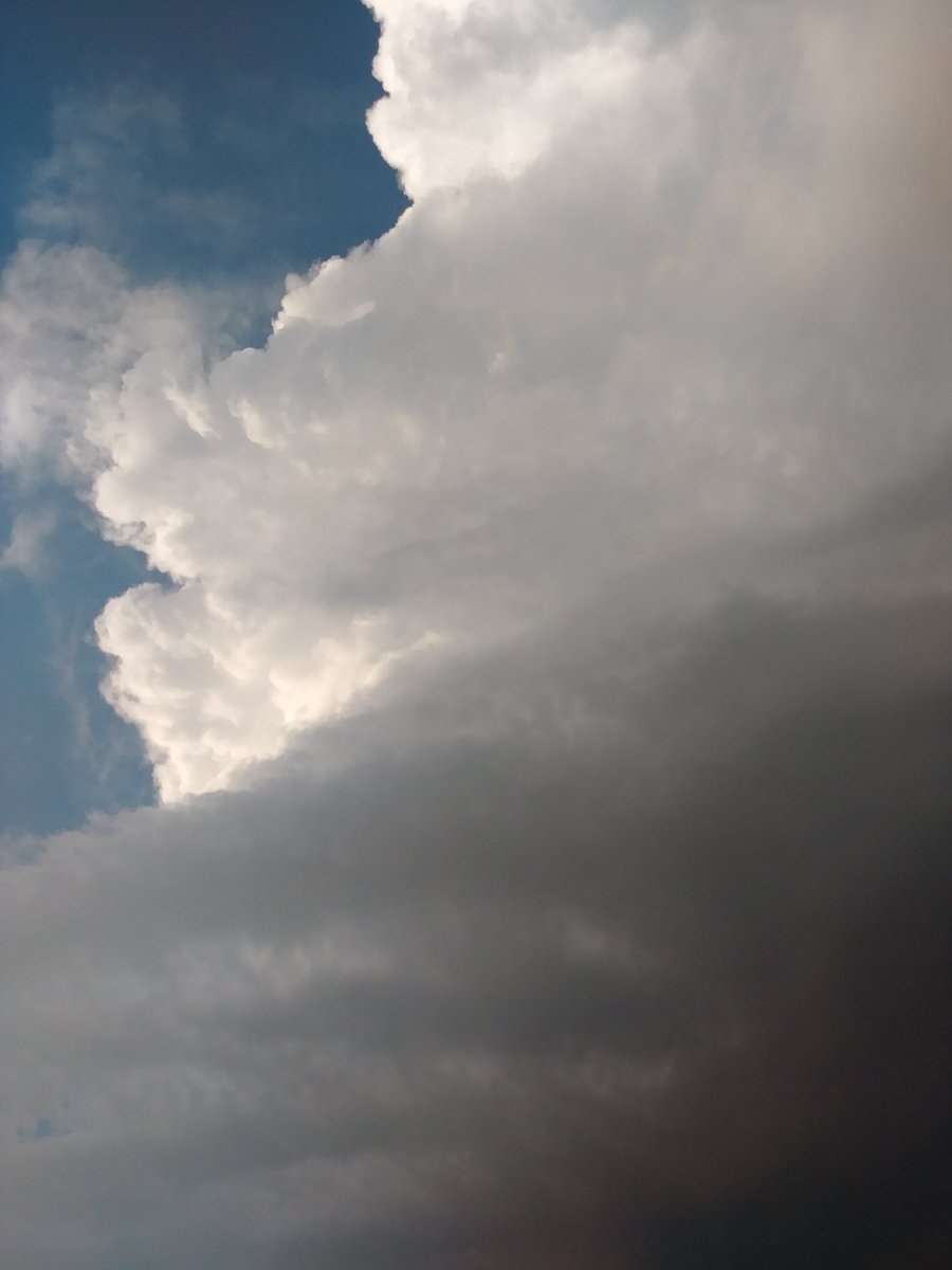
bubba hotep wrote:[url]https://pbs.twimg.com/media/D2dmFp2X0AER_H4.png[/url
[url]https://pbs.twimg.com/media/D2dlf7nXgAAAjdC.jpg[/url
[url]https://pbs.twimg.com/media/D2djwemW0AAknKD.jpg[/url
HOLY MOTHERSHIP!
2 likes
Weather geek and a storm spotter in West Austin. Not a degreed meteorologist. Big snow fan. Love rain and cold! Despise heat!
-
missygirl810

- Tropical Storm

- Posts: 154
- Joined: Fri Oct 27, 2017 3:07 pm
- Location: Celeste TX Hunt County Fannin Co line
Re: Texas Spring 2019
Looks like the cell passing through Keller might hit the big airport and Irving. Maybe north of me though. Unfortunately rain prospects don't look good after tonight.
Edit: The storm split in two with the heavy/hail portion entering Lewisville.
Edit: The storm split in two with the heavy/hail portion entering Lewisville.
0 likes
-
aggiecutter
- Category 5
- Posts: 1743
- Joined: Thu Oct 14, 2004 9:22 pm
- Location: Texarkana

-
CaptinCrunch

- S2K Supporter
- Posts: 8569
- Age: 56
- Joined: Mon Nov 03, 2003 4:33 pm
- Location: Lake Worth, TX (Tarrant Co.)
Return to “USA & Caribbean Weather”
Who is online
Users browsing this forum: No registered users and 149 guests