Texas Spring 2020

U.S. & Caribbean Weather Discussions and Severe Weather Events

Moderator: S2k Moderators

Forum rules

The posts in this forum are NOT official forecast and should not be used as such. They are just the opinion of the poster and may or may not be backed by sound meteorological data. They are NOT endorsed by any professional institution or STORM2K.

Help Support Storm2K
Message
Author
User avatar
bubba hotep
S2K Supporter
S2K Supporter
Posts: 5457
Joined: Wed Dec 28, 2016 1:00 am
Location: Collin County Texas

Re: Texas Spring 2020

#841 Postby bubba hotep » Thu May 21, 2020 10:33 pm

cheezyWXguy wrote:
bubba hotep wrote:Tough pattern :lol: FWD had 60% coverage for this afternoon, then lowered it to 30%, then we got nothing. Now the 3k NAM has this for tomorrow evening??

https://images.weatherbell.com/model/nam-nest-conus/dallas/refc/1590105600/1590192000-POyepy5I26U.png

Just saw that. Spc is going to have to expand that slight risk south if that run starts a trend.


Big change from earlier today

Image
1 likes   
Winter time post are almost exclusively focused on the DFW area.

Brent
S2K Supporter
S2K Supporter
Posts: 37096
Age: 35
Joined: Sun May 16, 2004 10:30 pm
Location: Tulsa Oklahoma
Contact:

Re: Texas Spring 2020

#842 Postby Brent » Fri May 22, 2020 1:12 am

Enhanced risk :double:

:double: . A COUPLE
STRONG TORNADOES MAY OCCUR WITH THE MORE DOMINANT SUPERCELLS, WITH
THE GREATEST POTENTIAL FROM BETWEEN WICHITA FALLS AND FORT WORTH
NORTHEASTWARD TO NEAR MCALESTER, OKLAHOMA.

Image
1 likes   
#neversummer

HockeyTx82
S2K Supporter
S2K Supporter
Posts: 1986
Joined: Tue Oct 27, 2009 11:17 am
Location: Ponder, TX

Re: Texas Spring 2020

#843 Postby HockeyTx82 » Fri May 22, 2020 3:56 am

Brent wrote:Enhanced risk :double:

:double: . A COUPLE
STRONG TORNADOES MAY OCCUR WITH THE MORE DOMINANT SUPERCELLS, WITH
THE GREATEST POTENTIAL FROM BETWEEN WICHITA FALLS AND FORT WORTH
NORTHEASTWARD TO NEAR MCALESTER, OKLAHOMA.

https://i.ibb.co/PcFH410/swody1-tornadoprob-2.png


Well that puts me in the crosshairs? What changed? Went from 0-60 like that....... will this be one of those days where people are caught off guard with the holiday weekend?
1 likes   
Don't hold me accountable for anything I post on this forum. Leave the real forecasting up to the professionals.

Location: Ponder, TX (all observation posts are this location unless otherwise noted)

User avatar
bubba hotep
S2K Supporter
S2K Supporter
Posts: 5457
Joined: Wed Dec 28, 2016 1:00 am
Location: Collin County Texas

Re: Texas Spring 2020

#844 Postby bubba hotep » Fri May 22, 2020 5:58 am

Image
0 likes   
Winter time post are almost exclusively focused on the DFW area.

HockeyTx82
S2K Supporter
S2K Supporter
Posts: 1986
Joined: Tue Oct 27, 2009 11:17 am
Location: Ponder, TX

Re: Texas Spring 2020

#845 Postby HockeyTx82 » Fri May 22, 2020 7:00 am

So not much mention of a Tornado threat in the NWS FWD graphics, yet SPC has a hatched area of sig...... what am I missing? FWD seems to think a later evening event for DFW.
1 likes   
Don't hold me accountable for anything I post on this forum. Leave the real forecasting up to the professionals.

Location: Ponder, TX (all observation posts are this location unless otherwise noted)

WacoWx
Category 2
Category 2
Posts: 565
Joined: Mon Dec 28, 2009 4:14 pm
Location: NOT Waco, TX ----> Dallas, TX

Re: Texas Spring 2020

#846 Postby WacoWx » Fri May 22, 2020 7:37 am

Decent upgrade and shift to the south. I will hold off on warning the friends as they are starting to think of me as the boy who cried wolf.
0 likes   

User avatar
jasons2k
Storm2k Executive
Storm2k Executive
Posts: 8076
Age: 50
Joined: Wed Jul 06, 2005 12:32 pm
Location: The Woodlands, TX

Re: Texas Spring 2020

#847 Postby jasons2k » Fri May 22, 2020 7:44 am

Latest update from Jeff Lindner:

Stormy weather pattern will begin this weekend and last through much of next week.

Upper level ridge of high pressure that has brought the heat and dry weather this week will break down today and Saturday allowing a slow moving trough to move into TX. Upper level pattern over the US will become “blocked” with high pressure on both the east and west coasts and low pressure over the central US. This setup will likely remain in place through the next 5-7 days.

As the upper level trough digs into TX Saturday and Sunday, rain chances will begin to increase. Capping seen today and for much of Saturday over SE TX will erode and by Sunday the air mass will be very capable of producing periods of showers and thunderstorms. Gulf moisture will continue to flow into the region for much of the next 5-7 days with PWS values of 1.8-2.2 inches nearly daily for this period which will help to fuel heavy rainfall. Some severe weather will also be possible each day, but the heavy rainfall threat is likely the bigger concern moving forward.

Complexes of thunderstorms will develop over portions of west and central TX today and Saturday and move toward SE TX, but likely fall apart before reaching the area. Complexes will have a better chance of reaching the area starting Sunday and into next week. Formation of a slow moving and meandering upper level low over west TX late this weekend and much of next week will only help to enhance and focus rain chances.

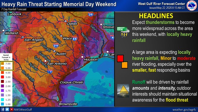
Forecasted rainfall amounts over the next 5-7 days will likely average 2-4 inches over much of the area…especially west of I-45 and isolated higher totals. Heavy rainfall is looking likely on Sunday and especially Monday for SE TX and we will need to closely monitor this period. Flooding will be possible with this pattern setup from this weekend into much of next week, especially as grounds begin to saturate producing more and more run-off. Given the widespread and repeated nature of the pattern of storm complexes rises on area rivers will be likely with the focus being across the Brazos and Colorado basins to start.

This is a weather pattern that could potentially produce a lot of impacts so it deserves attention.

Forecasted Rainfall Amounts (5 days):
Day 10 image not available

Jeff Lindner
Director Hydrologic Operations Division/Meteorologist
Harris County Flood Control District
9900 Northwest Freeway | Houston, Texas 77092
713-684-4000 (main) | 713-684-4165 (direct) | 281-924-2091 (cell)
jeff.lindner@hcfcd.org | Twitter: @jefflindner1
1 likes   

Ntxw
Storm2k Moderator
Storm2k Moderator
Posts: 21501
Joined: Wed Oct 21, 2009 6:34 pm
Location: DFW, Texas

Re: Texas Spring 2020

#848 Postby Ntxw » Fri May 22, 2020 7:48 am

HockeyTx82 wrote:So not much mention of a Tornado threat in the NWS FWD graphics, yet SPC has a hatched area of sig...... what am I missing? FWD seems to think a later evening event for DFW.


There will be some isolated risk initially but at this time isn't looking like anything major. Best bet is a line coming south out of the Red River valley late in the afternoon and evening hours. Any supercells that do form ahead will have good conditions to work with though.
1 likes   
The above post and any post by Ntxw is NOT an official forecast and should not be used as such. It is just the opinion of the poster and may or may not be backed by sound meteorological data. It is NOT endorsed by any professional institution including Storm2k. For official information, please refer to NWS products.

  Help support Storm2K!
Help Support Storm2K

HockeyTx82
S2K Supporter
S2K Supporter
Posts: 1986
Joined: Tue Oct 27, 2009 11:17 am
Location: Ponder, TX

Re: Texas Spring 2020

#849 Postby HockeyTx82 » Fri May 22, 2020 9:41 am

HRRR keeps putting big storms just W NW of DFW around 5PM.

Trend to watch for? Anyone else seeing what I am talking about?


Well the tornado threat from SPC went down, looks more hail now.

Looks to be a very fluid situation. When should we expect storms to start up at this point?
0 likes   
Don't hold me accountable for anything I post on this forum. Leave the real forecasting up to the professionals.

Location: Ponder, TX (all observation posts are this location unless otherwise noted)

rwfromkansas
Category 5
Category 5
Posts: 2169
Joined: Sat Aug 27, 2005 12:47 am
Location: North Fort Worth

Re: Texas Spring 2020

#850 Postby rwfromkansas » Fri May 22, 2020 9:57 am

The HRRR does have a huge line just north of DFW. Tech WRF has two rounds.
1 likes   

User avatar
bubba hotep
S2K Supporter
S2K Supporter
Posts: 5457
Joined: Wed Dec 28, 2016 1:00 am
Location: Collin County Texas

Re: Texas Spring 2020

#851 Postby bubba hotep » Fri May 22, 2020 10:56 am

Morning sounding from FWD was strongly capped and it looks like that is still holding strong, notice the rolling waves of low clouds behind the outflow. Now the question is how far south does that outflow move and does it stabilize things behind it? We got shutout by the outflow last week but were able to rebound with the big rain event the following day. Today's outflow is coming in much earlier in the day and looks like it might be washing out as most stations across DFW are still reporting southerly winds. Also, notice the cloud streets racing north from southern Texas, indicative of moist unstable air flowing northward.

Image
1 likes   
Winter time post are almost exclusively focused on the DFW area.

User avatar
bubba hotep
S2K Supporter
S2K Supporter
Posts: 5457
Joined: Wed Dec 28, 2016 1:00 am
Location: Collin County Texas

Re: Texas Spring 2020

#852 Postby bubba hotep » Fri May 22, 2020 11:15 am

Image

Image
1 likes   
Winter time post are almost exclusively focused on the DFW area.

User avatar
bubba hotep
S2K Supporter
S2K Supporter
Posts: 5457
Joined: Wed Dec 28, 2016 1:00 am
Location: Collin County Texas

Re: Texas Spring 2020

#853 Postby bubba hotep » Fri May 22, 2020 11:25 am

Image
2 likes   
Winter time post are almost exclusively focused on the DFW area.

User avatar
bubba hotep
S2K Supporter
S2K Supporter
Posts: 5457
Joined: Wed Dec 28, 2016 1:00 am
Location: Collin County Texas

Re: Texas Spring 2020

#854 Postby bubba hotep » Fri May 22, 2020 12:15 pm

HRRRs have really backed off on storms across N. TX later on today. I wonder if there is just too much subsidence left in the wake of the overnight MCS that moved just to our north?
0 likes   
Winter time post are almost exclusively focused on the DFW area.

DonWrk
Category 1
Category 1
Posts: 486
Age: 35
Joined: Mon Jan 03, 2011 11:54 pm
Location: Collinsville, TX

Re: Texas Spring 2020

#855 Postby DonWrk » Fri May 22, 2020 12:22 pm

bubba hotep wrote:HRRRs have really backed off on storms across N. TX later on today. I wonder if there is just too much subsidence left in the wake of the overnight MCS that moved just to our north?


McCauley still thinks it's a go. HRRR hasn't been showing much for a while and has sort of been all over the place to me.
0 likes   

rwfromkansas
Category 5
Category 5
Posts: 2169
Joined: Sat Aug 27, 2005 12:47 am
Location: North Fort Worth

Re: Texas Spring 2020

#856 Postby rwfromkansas » Fri May 22, 2020 12:53 pm

The HRRR seems to back off only to add it back before, so hopefully it’s wrong. Put some weed-killer down and need it watered in.
0 likes   

rwfromkansas
Category 5
Category 5
Posts: 2169
Joined: Sat Aug 27, 2005 12:47 am
Location: North Fort Worth

Re: Texas Spring 2020

#857 Postby rwfromkansas » Fri May 22, 2020 1:31 pm

Severe thunderstorm watch issued for west of DFW. Odd not to include DFW since that's where the core will come through assuming it happens.
0 likes   

HockeyTx82
S2K Supporter
S2K Supporter
Posts: 1986
Joined: Tue Oct 27, 2009 11:17 am
Location: Ponder, TX

Re: Texas Spring 2020

#858 Postby HockeyTx82 » Fri May 22, 2020 1:36 pm

rwfromkansas wrote:Severe thunderstorm watch issued for west of DFW. Odd not to include DFW since that's where the core will come through assuming it happens.


If you look at the

https://www.spc.noaa.gov/products/md/md0668.html

DFW and others are on the other side of the outflow. Perhaps it a little further SSW the thought earlier and will limit our severity? I think Bubba mentioned something about this earlier maybe making a difference.
0 likes   
Don't hold me accountable for anything I post on this forum. Leave the real forecasting up to the professionals.

Location: Ponder, TX (all observation posts are this location unless otherwise noted)

rwfromkansas
Category 5
Category 5
Posts: 2169
Joined: Sat Aug 27, 2005 12:47 am
Location: North Fort Worth

Re: Texas Spring 2020

#859 Postby rwfromkansas » Fri May 22, 2020 2:04 pm

HockeyTx82 wrote:
rwfromkansas wrote:Severe thunderstorm watch issued for west of DFW. Odd not to include DFW since that's where the core will come through assuming it happens.


If you look at the

https://www.spc.noaa.gov/products/md/md0668.html

DFW and others are on the other side of the outflow. Perhaps it a little further SSW the thought earlier and will limit our severity? I think Bubba mentioned something about this earlier maybe making a difference.


Maybe that's it. IMBY it's still 88 degrees with a good dewpoint and the wind is still SE for the boundary being south of me. But, maybe it will stabilize things enough.
0 likes   

User avatar
cheezyWXguy
Category 5
Category 5
Posts: 5529
Joined: Mon Feb 13, 2006 12:29 am
Location: Dallas, TX

Re: Texas Spring 2020

#860 Postby cheezyWXguy » Fri May 22, 2020 2:14 pm

HockeyTx82 wrote:
rwfromkansas wrote:Severe thunderstorm watch issued for west of DFW. Odd not to include DFW since that's where the core will come through assuming it happens.


If you look at the

https://www.spc.noaa.gov/products/md/md0668.html

DFW and others are on the other side of the outflow. Perhaps it a little further SSW the thought earlier and will limit our severity? I think Bubba mentioned something about this earlier maybe making a difference.


I don’t think this will be a major issue today. The outflow boundary likely stunts our potential for initial development, which is why it forecast to occur to our west. However, the atmosphere should recover sufficiently for these storms to meander into the dfw area. Things may get going as the low level jet kicks up later, according to the spc. If coverage is low these storms may miss the area as the hrrr shows, but it tends to underdo coverage, and the environment overall still seems supportive. Overall it doesn’t seem like the hrrr has performed well so far this year.
1 likes   


Return to “USA & Caribbean Weather”

Who is online

Users browsing this forum: CaptinCrunch, Cpv17 and 177 guests