
Texas Spring 2021
Moderator: S2k Moderators
Forum rules

The posts in this forum are NOT official forecast and should not be used as such. They are just the opinion of the poster and may or may not be backed by sound meteorological data. They are NOT endorsed by any professional institution or STORM2K.
-
Iceresistance

- Category 5

- Posts: 8910
- Age: 20
- Joined: Sat Oct 10, 2020 9:45 am
- Location: Tecumseh, OK/Norman, OK
Re: Texas Spring 2021
More severe weather expected in North-Central Texas into Oklahoma & Southern Kansas next Tuesday (7 days out)
0 likes
Bill 2015 & Beta 2020
Winter 2020-2021
All observations are in Tecumseh, OK unless otherwise noted.
Winter posts are focused mainly for Oklahoma & Texas.
Take any of my forecasts with a grain of salt, refer to the NWS, SPC, and NHC for official information
Never say Never with weather! Because ANYTHING is possible!
Winter 2020-2021
All observations are in Tecumseh, OK unless otherwise noted.
Winter posts are focused mainly for Oklahoma & Texas.
Take any of my forecasts with a grain of salt, refer to the NWS, SPC, and NHC for official information
Never say Never with weather! Because ANYTHING is possible!
-
InfernoFlameCat

- Category 5
- Posts: 1966
- Age: 21
- Joined: Mon Dec 14, 2020 10:52 am
- Location: Buford, GA
Re: Texas Spring 2021
Ntxw wrote:DFW airport hit a record low of 37F this morning beating out 39F back in 1918.
Is this like a mild spring version of whatever polar freak storm occurred in February?
0 likes
I am by no means a professional. DO NOT look at my forecasts for official information or make decisions based on what I post.
Goal: to become a registered expert over tropical and subtropical cyclones.
Goal: to become a registered expert over tropical and subtropical cyclones.
-
Iceresistance
- Category 5
- Posts: 8910
- Age: 20
- Joined: Sat Oct 10, 2020 9:45 am
- Location: Tecumseh, OK/Norman, OK
Re: Texas Spring 2021
InfernoFlameCat wrote:Ntxw wrote:DFW airport hit a record low of 37F this morning beating out 39F back in 1918.
Is this like a mild spring version of whatever polar freak storm occurred in February?
Yes, got down to 30°F this morning . . .
0 likes
Bill 2015 & Beta 2020
Winter 2020-2021
All observations are in Tecumseh, OK unless otherwise noted.
Winter posts are focused mainly for Oklahoma & Texas.
Take any of my forecasts with a grain of salt, refer to the NWS, SPC, and NHC for official information
Never say Never with weather! Because ANYTHING is possible!
Winter 2020-2021
All observations are in Tecumseh, OK unless otherwise noted.
Winter posts are focused mainly for Oklahoma & Texas.
Take any of my forecasts with a grain of salt, refer to the NWS, SPC, and NHC for official information
Never say Never with weather! Because ANYTHING is possible!
-
Iceresistance
- Category 5
- Posts: 8910
- Age: 20
- Joined: Sat Oct 10, 2020 9:45 am
- Location: Tecumseh, OK/Norman, OK
Re: Texas Spring 2021
Iceresistance wrote:More severe weather expected in North-Central Texas into Oklahoma & Southern Kansas next Tuesday (7 days out)
https://s3.gifyu.com/images/day7prob.gif
Forgot to mention that the setup is looking crazy, especially in Oklahoma
- High CAPE
- Very strong Jet Stream
- Very deep, rich Low-Level Moisture
- Strong Cap (Only allows the strongest Supercells to form)
- Triple Point appears to be likely in West-Central Oklahoma
1 likes
Bill 2015 & Beta 2020
Winter 2020-2021
All observations are in Tecumseh, OK unless otherwise noted.
Winter posts are focused mainly for Oklahoma & Texas.
Take any of my forecasts with a grain of salt, refer to the NWS, SPC, and NHC for official information
Never say Never with weather! Because ANYTHING is possible!
Winter 2020-2021
All observations are in Tecumseh, OK unless otherwise noted.
Winter posts are focused mainly for Oklahoma & Texas.
Take any of my forecasts with a grain of salt, refer to the NWS, SPC, and NHC for official information
Never say Never with weather! Because ANYTHING is possible!
-
InfernoFlameCat
- Category 5
- Posts: 1966
- Age: 21
- Joined: Mon Dec 14, 2020 10:52 am
- Location: Buford, GA
Re: Texas Spring 2021
Yum. Those will be some nice looking supercells that spin up. They look alot neater than Dixie supercells.
0 likes
I am by no means a professional. DO NOT look at my forecasts for official information or make decisions based on what I post.
Goal: to become a registered expert over tropical and subtropical cyclones.
Goal: to become a registered expert over tropical and subtropical cyclones.
-
WacoWx
- Category 2

- Posts: 556
- Joined: Mon Dec 28, 2009 4:14 pm
- Location: NOT Waco, TX ----> Dallas, TX
Re: Texas Spring 2021
Reed Timmer thinks Friday in eastern and NE Texas will be where a biggest threat for tornados will be, near and after sunset. The dryline threat will have a tornadic threat as well, but not as dangerous as the east/NE Texas supercells.
0 likes
-
InfernoFlameCat
- Category 5
- Posts: 1966
- Age: 21
- Joined: Mon Dec 14, 2020 10:52 am
- Location: Buford, GA
Re: Texas Spring 2021
WacoWx wrote:Reed Timmer thinks Friday in eastern and NE Texas will be where a biggest threat for tornados will be, near and after sunset. The dryline threat will have a tornadic threat as well, but not as dangerous as the east/NE Texas supercells.
Yeah because the storms farther west will be more elevated because of a lack of moisture. Some large hail there likely though and very beautiful LP supercells.
0 likes
I am by no means a professional. DO NOT look at my forecasts for official information or make decisions based on what I post.
Goal: to become a registered expert over tropical and subtropical cyclones.
Goal: to become a registered expert over tropical and subtropical cyclones.
-
WacoWx
- Category 2
- Posts: 556
- Joined: Mon Dec 28, 2009 4:14 pm
- Location: NOT Waco, TX ----> Dallas, TX
Re: Texas Spring 2021
I'm thinking that the view off to the east after the dryline passes will be an electric one.
1 likes
-
jasons2k

- Storm2k Executive

- Posts: 8071
- Age: 50
- Joined: Wed Jul 06, 2005 12:32 pm
- Location: The Woodlands, TX
Re: Texas Spring 2021
The temperature was a chilly 45 degrees here this morning. Too cold for late April.
No complaining this summer that Texas never has a spring, or that we go straight from winter to summer. Not this year at least.
Most of the severe action on Friday looks to be north of here, which is typical. I'm watching Friday's system and also the one setting-up for next week. It's that time of year...
0 likes
Re: Texas Spring 2021
InfernoFlameCat wrote:WacoWx wrote:Reed Timmer thinks Friday in eastern and NE Texas will be where a biggest threat for tornados will be, near and after sunset. The dryline threat will have a tornadic threat as well, but not as dangerous as the east/NE Texas supercells.
Yeah because the storms farther west will be more elevated because of a lack of moisture. Some large hail there likely though and very beautiful LP supercells.
I don't think that moisture will be the issue. The NAM is showing a very sharp dryline with dew points in the upper 60's to near 70 ahead of it with surface-based CAPE values of 3,000-3,500. The bigger threat for tornadoes would be further East after sunset because that's when the LLJ will crank up increasing helicity values. Forecast soundings in the DFW area also have quite a bit of veer, back, veer. That being said, any mesoscale boundaries would need to be watched for locally enhanced helicity.
0 likes
-
Lagreeneyes03
- Category 1

- Posts: 476
- Joined: Mon Dec 09, 2013 10:53 am
- Location: Luxurious Lake Grapevine
Re: Texas Spring 2021
WacoWx wrote:Reed Timmer thinks Friday in eastern and NE Texas will be where a biggest threat for tornados will be, near and after sunset. The dryline threat will have a tornadic threat as well, but not as dangerous as the east/NE Texas supercells.
DFW safe?-
Personally worried about my parents who moved to their retirement RV up in Ardmore-thinking I should go up and help them move stuff around and prep for the coming week or 2. Thoughts?
0 likes
I'm a Princess, not a forecaster.
-
Iceresistance
- Category 5
- Posts: 8910
- Age: 20
- Joined: Sat Oct 10, 2020 9:45 am
- Location: Tecumseh, OK/Norman, OK
Re: Texas Spring 2021
Slight Risk still very broad for most of Texas . . .

Up to Baseball sized hail not out of the question . . .

The tornado threat is also higher in Eastern & Northern Texas

Up to Baseball sized hail not out of the question . . .
The tornado threat is also higher in Eastern & Northern Texas
0 likes
Bill 2015 & Beta 2020
Winter 2020-2021
All observations are in Tecumseh, OK unless otherwise noted.
Winter posts are focused mainly for Oklahoma & Texas.
Take any of my forecasts with a grain of salt, refer to the NWS, SPC, and NHC for official information
Never say Never with weather! Because ANYTHING is possible!
Winter 2020-2021
All observations are in Tecumseh, OK unless otherwise noted.
Winter posts are focused mainly for Oklahoma & Texas.
Take any of my forecasts with a grain of salt, refer to the NWS, SPC, and NHC for official information
Never say Never with weather! Because ANYTHING is possible!
-
Iceresistance
- Category 5
- Posts: 8910
- Age: 20
- Joined: Sat Oct 10, 2020 9:45 am
- Location: Tecumseh, OK/Norman, OK
Re: Texas Spring 2021
Northern & Central Texas is expecting severe storms next Tuesday . . .

0 likes
Bill 2015 & Beta 2020
Winter 2020-2021
All observations are in Tecumseh, OK unless otherwise noted.
Winter posts are focused mainly for Oklahoma & Texas.
Take any of my forecasts with a grain of salt, refer to the NWS, SPC, and NHC for official information
Never say Never with weather! Because ANYTHING is possible!
Winter 2020-2021
All observations are in Tecumseh, OK unless otherwise noted.
Winter posts are focused mainly for Oklahoma & Texas.
Take any of my forecasts with a grain of salt, refer to the NWS, SPC, and NHC for official information
Never say Never with weather! Because ANYTHING is possible!
-
Iceresistance
- Category 5
- Posts: 8910
- Age: 20
- Joined: Sat Oct 10, 2020 9:45 am
- Location: Tecumseh, OK/Norman, OK
Re: Texas Spring 2021
Latest 9z SREF model run may warrant a Enhanced risk in SE Texas Tomorrow . . .

0 likes
Bill 2015 & Beta 2020
Winter 2020-2021
All observations are in Tecumseh, OK unless otherwise noted.
Winter posts are focused mainly for Oklahoma & Texas.
Take any of my forecasts with a grain of salt, refer to the NWS, SPC, and NHC for official information
Never say Never with weather! Because ANYTHING is possible!
Winter 2020-2021
All observations are in Tecumseh, OK unless otherwise noted.
Winter posts are focused mainly for Oklahoma & Texas.
Take any of my forecasts with a grain of salt, refer to the NWS, SPC, and NHC for official information
Never say Never with weather! Because ANYTHING is possible!
-
vbhoutex

- Storm2k Executive
- Posts: 28972
- Age: 72
- Joined: Wed Oct 09, 2002 11:31 pm
- Location: Spring Branch area, Houston, TX
- Contact:
Re: Texas Spring 2021
From Jeff Lindner:
There will be a risk of severe thunderstorms Friday afternoon and evening over much of eastern TX.
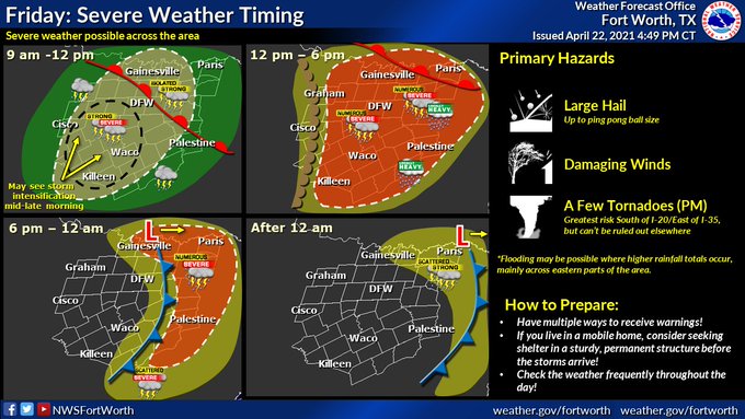
Surface high pressure is shifting eastward this morning allowing onshore flow to commence over SE TX and this will increase today allowing a quick return of Gulf moisture ahead of an approaching storm system that will move out of the southern Rockies tonight into Friday. Surface low pressure will develop over the TX/OK panhandles on Friday and move ENE with a strong dryline developing across central TX. Parameters during the day…especially the afternoon and evening become increasingly favorable for the development of showers and thunderstorms over SE TX with increasing divergence aloft, increasing low level jet, steepening mid level lapse rates, and large scale lift. One question remains and has plagued the area for much of the spring is the intensity of the mid level cap and if this feature will preclude storms from developing as has been the case several times this spring. Capping appears strongest near the coast and these areas could remain capped through the entire event with areas north of I-10 likely having the highest chances for showers and thunderstorms.
As for the severe threat, several parameters are in place for severe thunderstorms to develop with all severe modes in play (large hail, damaging winds, and tornadoes). Think the large hail threat will be most likely along the dryline and generally to the west of our area where discrete supercells will develop by mid to late afternoon Friday…some of this activity will likely make it eastward into our western counties where a very large hail threat will exist. By evening expect storms to transition more toward lines and segments with the hail threat becoming more a damaging wind potential. While the tornado threat is low it is not zero and there is decent turning in the low level wind profiles, but the expectations that storms will become more linear with time generally reduces the overall tornado threat.
0 likes
Skywarn, C.E.R.T.
Please click below to donate to STORM2K to help with the expenses of keeping the site going:

Please click below to donate to STORM2K to help with the expenses of keeping the site going:
-
Iceresistance
- Category 5
- Posts: 8910
- Age: 20
- Joined: Sat Oct 10, 2020 9:45 am
- Location: Tecumseh, OK/Norman, OK
Re: Texas Spring 2021
vbhoutex wrote:From Jeff Lindner:There will be a risk of severe thunderstorms Friday afternoon and evening over much of eastern TX.
Surface high pressure is shifting eastward this morning allowing onshore flow to commence over SE TX and this will increase today allowing a quick return of Gulf moisture ahead of an approaching storm system that will move out of the southern Rockies tonight into Friday. Surface low pressure will develop over the TX/OK panhandles on Friday and move ENE with a strong dryline developing across central TX. Parameters during the day…especially the afternoon and evening become increasingly favorable for the development of showers and thunderstorms over SE TX with increasing divergence aloft, increasing low level jet, steepening mid level lapse rates, and large scale lift. One question remains and has plagued the area for much of the spring is the intensity of the mid level cap and if this feature will preclude storms from developing as has been the case several times this spring. Capping appears strongest near the coast and these areas could remain capped through the entire event with areas north of I-10 likely having the highest chances for showers and thunderstorms.
As for the severe threat, several parameters are in place for severe thunderstorms to develop with all severe modes in play (large hail, damaging winds, and tornadoes). Think the large hail threat will be most likely along the dryline and generally to the west of our area where discrete supercells will develop by mid to late afternoon Friday…some of this activity will likely make it eastward into our western counties where a very large hail threat will exist. By evening expect storms to transition more toward lines and segments with the hail threat becoming more a damaging wind potential. While the tornado threat is low it is not zero and there is decent turning in the low level wind profiles, but the expectations that storms will become more linear with time generally reduces the overall tornado threat.
Yeah, I'm closer to the Triple Point . . .
The SPC has this on why the Slight Risk is very broad right now, but what may happen if any storms should fire up in the risk zone . . .
There is still a fair amount of uncertainty how much convection will
develop along the dryline in central TX/southwestern OK through
Friday afternoon. Most guidance suggests the possibility of a
bimodal distribution of storms across the southern Plains, with the
triple point in southwestern OK late Friday afternoon and a
low-level warm advection regime in east/coastal TX through the
daytime hours being favored zones of initiation. Still, there
appears to be at least some chance for additional robust
thunderstorm development posing mainly an isolated large to very
large hail threat farther west along the dryline by peak afternoon
heating, as modest large-scale ascent with the upper trough
overspreads the southern Plains. Based on latest guidance being in
better agreement on the placement/eastward extent of the dryline,
severe probabilities have been adjusted slightly eastward in central
TX.
Any thunderstorms that form near the triple point in southwestern OK
will likely become severe supercells quickly. The main threat
initially should be large to perhaps very large (2+ inch diameter)
hail given steep mid-level lapse rates around 8 C/km, sufficient
low-level moisture and diurnal heating to support 1500-2500 J/kg of
MLCAPE, and effective bulk shear of 40-50 kt. By early Friday
evening, a modest strengthening of the low-level flow and gradually
increasing low-level moisture may support an isolated tornado threat
with any storms that can remain discrete. Although details remain
unclear, there also appears to be some potential for upscale growth
into a line or bow Friday evening/night as the cold front advances
southeastward. Damaging winds would become a greater risk across
parts of central OK into north TX if this upscale growth occurrs.
0 likes
Bill 2015 & Beta 2020
Winter 2020-2021
All observations are in Tecumseh, OK unless otherwise noted.
Winter posts are focused mainly for Oklahoma & Texas.
Take any of my forecasts with a grain of salt, refer to the NWS, SPC, and NHC for official information
Never say Never with weather! Because ANYTHING is possible!
Winter 2020-2021
All observations are in Tecumseh, OK unless otherwise noted.
Winter posts are focused mainly for Oklahoma & Texas.
Take any of my forecasts with a grain of salt, refer to the NWS, SPC, and NHC for official information
Never say Never with weather! Because ANYTHING is possible!
-
jasons2k
- Storm2k Executive
- Posts: 8071
- Age: 50
- Joined: Wed Jul 06, 2005 12:32 pm
- Location: The Woodlands, TX
Re: Texas Spring 2021
Iceresistance wrote:Latest 9z SREF model run may warrant a Enhanced risk in SE Texas Tomorrow . . .
With that tilt I’d say so...
0 likes
-
bubba hotep

- S2K Supporter

- Posts: 5454
- Joined: Wed Dec 28, 2016 1:00 am
- Location: Collin County Texas
Re: Texas Spring 2021
Still more questions than answers for tomorrow. Maybe the 00z CAMs will clear things up.
0 likes
Winter time post are almost exclusively focused on the DFW area.
-
Iceresistance
- Category 5
- Posts: 8910
- Age: 20
- Joined: Sat Oct 10, 2020 9:45 am
- Location: Tecumseh, OK/Norman, OK
Re: Texas Spring 2021
bubba hotep wrote:Still more questions than answers for tomorrow. Maybe the 00z CAMs will clear things up.
https://pbs.twimg.com/media/EznB-aQUcAIUgNn?format=jpg&name=small
The Model Uncertainty is too high right now, maybe the Midnight Model runs may clear things up as well . . .
(Don't forget the HRRR!)
0 likes
Bill 2015 & Beta 2020
Winter 2020-2021
All observations are in Tecumseh, OK unless otherwise noted.
Winter posts are focused mainly for Oklahoma & Texas.
Take any of my forecasts with a grain of salt, refer to the NWS, SPC, and NHC for official information
Never say Never with weather! Because ANYTHING is possible!
Winter 2020-2021
All observations are in Tecumseh, OK unless otherwise noted.
Winter posts are focused mainly for Oklahoma & Texas.
Take any of my forecasts with a grain of salt, refer to the NWS, SPC, and NHC for official information
Never say Never with weather! Because ANYTHING is possible!
-
Iceresistance
- Category 5
- Posts: 8910
- Age: 20
- Joined: Sat Oct 10, 2020 9:45 am
- Location: Tecumseh, OK/Norman, OK
Re: Texas Spring 2021
400 Posts!
Enhanced risk in Eastern Texas, Central & Southern Oklahoma for wind . . .

Enhanced risk in Eastern Texas, Central & Southern Oklahoma for wind . . .
0 likes
Bill 2015 & Beta 2020
Winter 2020-2021
All observations are in Tecumseh, OK unless otherwise noted.
Winter posts are focused mainly for Oklahoma & Texas.
Take any of my forecasts with a grain of salt, refer to the NWS, SPC, and NHC for official information
Never say Never with weather! Because ANYTHING is possible!
Winter 2020-2021
All observations are in Tecumseh, OK unless otherwise noted.
Winter posts are focused mainly for Oklahoma & Texas.
Take any of my forecasts with a grain of salt, refer to the NWS, SPC, and NHC for official information
Never say Never with weather! Because ANYTHING is possible!
Return to “USA & Caribbean Weather”
Who is online
Users browsing this forum: No registered users and 64 guests