Texas Summer 2021

U.S. & Caribbean Weather Discussions and Severe Weather Events

Moderator: S2k Moderators

Forum rules

The posts in this forum are NOT official forecast and should not be used as such. They are just the opinion of the poster and may or may not be backed by sound meteorological data. They are NOT endorsed by any professional institution or STORM2K.

Help Support Storm2K
Message
Author
Brent
S2K Supporter
S2K Supporter
Posts: 37125
Age: 35
Joined: Sun May 16, 2004 10:30 pm
Location: Tulsa Oklahoma
Contact:

Re: Texas Summer 2021

#21 Postby Brent » Wed Jun 02, 2021 6:17 pm

captainbarbossa19 wrote:
rwfromkansas wrote:75 at noon on June 2. Amazing. Only downside is it’s not hot enough for neighborhood pool.


Do not worry. The heat always finds a way in Texas. :wink:


Lol yes I'm sure we'll be complaining soon enough :spam: even up here I saw a 90 on the 10 day last night
0 likes   
#neversummer

User avatar
bubba hotep
S2K Supporter
S2K Supporter
Posts: 5527
Joined: Wed Dec 28, 2016 1:00 am
Location: Collin County Texas

Re: Texas Summer 2021

#22 Postby bubba hotep » Wed Jun 02, 2021 7:34 pm

There have been a number of Flash Flood Warnings out across Western Texas this afternoon.

Also, what is this boundary on radar? Sea breeze?

Image
0 likes   
Winter time post are almost exclusively focused on the DFW area.

User avatar
jasons2k
Storm2k Executive
Storm2k Executive
Posts: 8083
Age: 50
Joined: Wed Jul 06, 2005 12:32 pm
Location: The Woodlands, TX

Re: Texas Summer 2021

#23 Postby jasons2k » Wed Jun 02, 2021 7:59 pm

Yep, that's the sea breeze.

Lots of rain on the way. With the ground already saturated, we will probably see a lot more widespread flash flooding than the last couple of events.
2 likes   

User avatar
Haris
Category 5
Category 5
Posts: 1808
Joined: Mon Nov 27, 2017 8:19 pm
Location: ( Bee Cave) West Austin, Texas

Re: Texas Summer 2021

#24 Postby Haris » Thu Jun 03, 2021 12:02 am

Pretty good storm cluster this evening across Austin. Ever since last Fri, have seen over 4” total.
2 likes   
Weather geek and a storm spotter in West Austin. Not a degreed meteorologist. Big snow fan. Love rain and cold! Despise heat!

User avatar
bubba hotep
S2K Supporter
S2K Supporter
Posts: 5527
Joined: Wed Dec 28, 2016 1:00 am
Location: Collin County Texas

Re: Texas Summer 2021

#25 Postby bubba hotep » Thu Jun 03, 2021 3:11 pm

More rain on the way for Texas

Image

Mesoscale Precipitation Discussion 0271
NWS Weather Prediction Center College Park MD
334 PM EDT Thu Jun 03 2021

Areas affected...TX/LA

Concerning...Heavy rainfall...Flash flooding possible

Valid 031933Z - 040133Z

Summary...An isolated to scattered flash flood risk continues
across portions of south TX. Further east, a localized flash flood
risk may also exist over southeast TX into southwest LA.

Discussion...A convective cluster continues to slowly drift
southward over south central TX this afternoon. Expect continued
convective development along this outflow as it moves into an
environment characterized by ~2000 J/KG of MLCAPE. We are also
seeing some discrete development downstream of this activity over
south TX. Mean flow supports a south to north movement of
cells...however the entire convective cluster is propagating
southward. Thus we are likely to see some cell mergers through the
afternoon hours as convective development continues over south TX.

PWs around 2" and a deep warm cloud layer will continue to support
efficient rainfall in any of the stronger cells. Would continue to
expect localized hourly rainfall of 3". Wet antecedent conditions
and soil moisture running above average across this portion of
south TX, combined with the expected rainfall rates, supports an
isolated to scattered flash flood risk where cell mergers occur
into the evening hours.

Further east over southeast TX and southwest LA, convective cells
are developing along a stationary boundary just inland of the Gulf
Coast. These cells will be slow moving near the boundary, and will
generally pulse up and down quick enough at any one location to
limit the extent of the flash flood risk. However we probably have
just enough deep layer shear to support some multi cell activity,
which may persist/merge enough to locally result in some 2-3"
rainfall totals in an hour or two resulting in isolated flash
flooding here as well.

Chenard

ATTN...WFO...BRO...CRP...EWX...HGX...LCH...
0 likes   
Winter time post are almost exclusively focused on the DFW area.

User avatar
bubba hotep
S2K Supporter
S2K Supporter
Posts: 5527
Joined: Wed Dec 28, 2016 1:00 am
Location: Collin County Texas

Re: Texas Summer 2021

#26 Postby bubba hotep » Thu Jun 03, 2021 8:35 pm

Flash Flood Watch for Deep South Texas

Image
0 likes   
Winter time post are almost exclusively focused on the DFW area.

User avatar
Haris
Category 5
Category 5
Posts: 1808
Joined: Mon Nov 27, 2017 8:19 pm
Location: ( Bee Cave) West Austin, Texas

Re: Texas Summer 2021

#27 Postby Haris » Thu Jun 03, 2021 9:39 pm

another 1.2 at my place W Austin. May 2015 (now June) all over again
2 likes   
Weather geek and a storm spotter in West Austin. Not a degreed meteorologist. Big snow fan. Love rain and cold! Despise heat!

DonWrk
Category 1
Category 1
Posts: 486
Age: 35
Joined: Mon Jan 03, 2011 11:54 pm
Location: Collinsville, TX

Re: Texas Summer 2021

#28 Postby DonWrk » Sat Jun 05, 2021 8:56 am

At the 1.00" mark up here this morning. Surprised how the radar looked when I woke up!
2 likes   

User avatar
bubba hotep
S2K Supporter
S2K Supporter
Posts: 5527
Joined: Wed Dec 28, 2016 1:00 am
Location: Collin County Texas

Re: Texas Summer 2021

#29 Postby bubba hotep » Sat Jun 05, 2021 10:42 am

Time to start watching the BOC and what might come up late next week.

Image

Image
1 likes   
Winter time post are almost exclusively focused on the DFW area.

HockeyTx82
S2K Supporter
S2K Supporter
Posts: 2011
Joined: Tue Oct 27, 2009 11:17 am
Location: Ponder, TX

Re: Texas Summer 2021

#30 Postby HockeyTx82 » Sat Jun 05, 2021 9:12 pm

bubba hotep wrote:Time to start watching the BOC and what might come up late next week.

https://i.ibb.co/0GyYCTD/ecmwf-ens-z500a-Mean-namer-6.png

https://i.ibb.co/c6LMRyd/compday-ds73-BTe-T2p.gif


What are you referring to? I'm not sure what I am looking at.
0 likes   
Don't hold me accountable for anything I post on this forum. Leave the real forecasting up to the professionals.

Location: Ponder, TX (all observation posts are this location unless otherwise noted)

User avatar
bubba hotep
S2K Supporter
S2K Supporter
Posts: 5527
Joined: Wed Dec 28, 2016 1:00 am
Location: Collin County Texas

Re: Texas Summer 2021

#31 Postby bubba hotep » Sat Jun 05, 2021 9:29 pm

Flash Flood Warning right along the 75 corridor.

Image
0 likes   
Winter time post are almost exclusively focused on the DFW area.

User avatar
bubba hotep
S2K Supporter
S2K Supporter
Posts: 5527
Joined: Wed Dec 28, 2016 1:00 am
Location: Collin County Texas

Re: Texas Summer 2021

#32 Postby bubba hotep » Sat Jun 05, 2021 9:32 pm

Some new cells popping back SW, maybe the airport can officially pick up some rain out of this. The DFW airport picked up 7.77" or rain in May but the DFW area avg about 9.5" with Ft. Alliance coming in with nearly 12".

Image
0 likes   
Winter time post are almost exclusively focused on the DFW area.

User avatar
somethingfunny
ChatStaff
ChatStaff
Posts: 3926
Age: 35
Joined: Thu May 31, 2007 10:30 pm
Location: McKinney, Texas

Re: Texas Summer 2021

#33 Postby somethingfunny » Sat Jun 05, 2021 11:17 pm

This is a rain bomb over the northern metro, just sitting and POURING rain and back building over the same areas for hours... I'm glad I'm home now. Stay safe out there!
1 likes   
I am not a meteorologist, and any posts made by me are not official forecasts or to be interpreted as being intelligent. These posts are just my opinions and are probably silly opinions.

User avatar
bubba hotep
S2K Supporter
S2K Supporter
Posts: 5527
Joined: Wed Dec 28, 2016 1:00 am
Location: Collin County Texas

Re: Texas Summer 2021

#34 Postby bubba hotep » Sat Jun 05, 2021 11:25 pm

Image

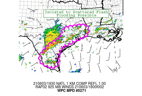
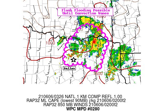
Mesoscale Precipitation Discussion 0280
NWS Weather Prediction Center College Park MD
1128 PM EDT Sat Jun 05 2021

Areas affected...Northeast Texas...Far Southern Oklahoma

Concerning...Heavy rainfall...Flash flooding possible

Valid 060328Z - 060700Z

Summary...Isolated flash flooding may continue across portions of
North Texas and far southern Oklahoma through the early overnight
hours with rainfall rates as high as 2-3"/hr.

Discussion...Deep convection is expanding across portions of
northeastern Texas late this evening, amid a highly favorable
mesoscale environment for heavy rainfall (as well as relatively
slow storm motions). SPC mesoscale analysis indicates MLCAPE of
1000-1500 J/kg, PWATS of 1.7-1.8 inches (above the 90th percentile
for FWD), and effective bulk shear of near 20 kts. In addition,
the placement of a synoptic scale upper-level low over central TX
is providing a fair amount of divergence/diffluence aloft. These
factors, along with a weak low-level jet (20 kts) and modest
925-850 mb moisture transport, should continue to foster upscale
growth of convection over the next several hours.

The just in 00z HREF suite also suggests that convection will be
able to continue to proliferate through 06z. The probability
matched mean (PMM) QPF suggests an additional 2-3" is possible
over a fairly broad area over northeastern Dallas and points
northeastward (toward far southern Oklahoma). The current
convective trends bear this out, as radar and satellite imagery
depict continued storm mergers and outflow enhanced convergence
over an analyzed region of deep moisture convergence. 00z HREF
40-km neighborhood probabilities suggest a 30% chance of 3-inch
exceedance over the next several hours. This 3-inch exceedance has
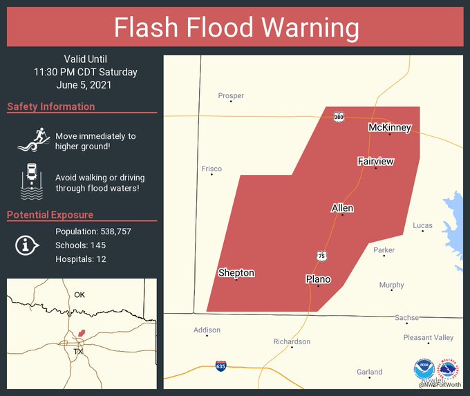
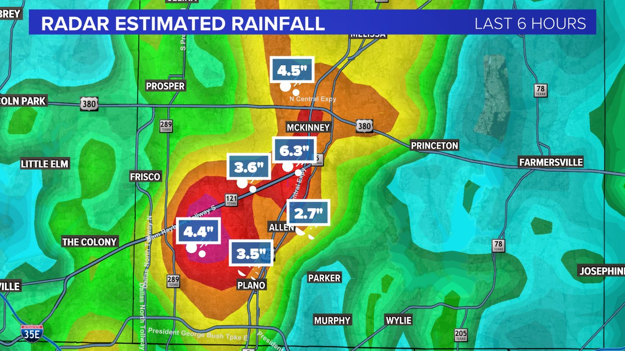
already been realized just north of Dallas (near Allen, TX),
according to dual-pol radar estimates via KFWS (as well as MRMS
3-hr QPF through 03z) which depicts an area where 5+ inches of
rain has already fallen. Hydrologically, much of the surrounding
area is already relatively saturated, as NASA SPoRT-LIS soil
moisture percentiles average above the 70th percentile.

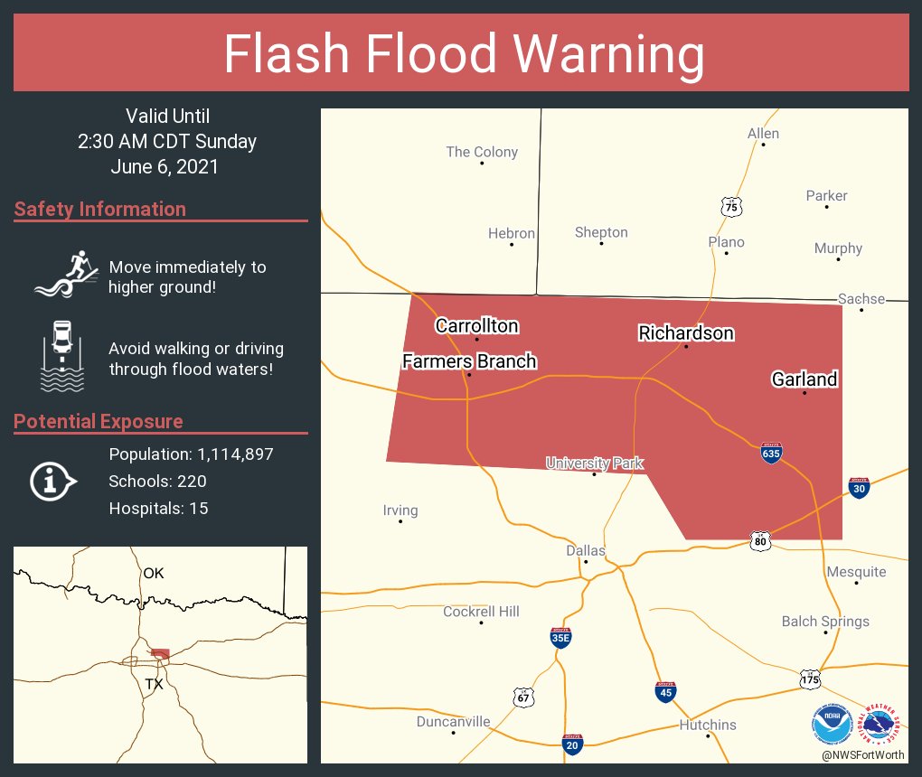
Given these latest convective trends, the 00z CAM output, and
antecedent soil conditions, flash flooding will continue to be
possible through 07z. Of particular concern is the prospect of
convection backward-propagating farther into the Dallas-Fort Worth
metro area, given the relatively slow storm motions and high
rainfall rates.

Churchill

ATTN...WFO...FWD...OUN...SHV...TSA...
1 likes   
Winter time post are almost exclusively focused on the DFW area.

User avatar
bubba hotep
S2K Supporter
S2K Supporter
Posts: 5527
Joined: Wed Dec 28, 2016 1:00 am
Location: Collin County Texas

Re: Texas Summer 2021

#35 Postby bubba hotep » Sat Jun 05, 2021 11:27 pm

Estimated totals so far and lightning is pickup outside again.

Image
0 likes   
Winter time post are almost exclusively focused on the DFW area.

User avatar
bubba hotep
S2K Supporter
S2K Supporter
Posts: 5527
Joined: Wed Dec 28, 2016 1:00 am
Location: Collin County Texas

Re: Texas Summer 2021

#36 Postby bubba hotep » Sat Jun 05, 2021 11:34 pm

New Flash Flood Warning

Image
0 likes   
Winter time post are almost exclusively focused on the DFW area.

User avatar
bubba hotep
S2K Supporter
S2K Supporter
Posts: 5527
Joined: Wed Dec 28, 2016 1:00 am
Location: Collin County Texas

Re: Texas Summer 2021

#37 Postby bubba hotep » Sat Jun 05, 2021 11:35 pm

I'm fighting to get the Summer Thread to at least 5 pages this year!
4 likes   
Winter time post are almost exclusively focused on the DFW area.

User avatar
bubba hotep
S2K Supporter
S2K Supporter
Posts: 5527
Joined: Wed Dec 28, 2016 1:00 am
Location: Collin County Texas

Re: Texas Summer 2021

#38 Postby bubba hotep » Sun Jun 06, 2021 12:00 am

Absolutely dumping here again IMBY.
1 likes   
Winter time post are almost exclusively focused on the DFW area.

User avatar
somethingfunny
ChatStaff
ChatStaff
Posts: 3926
Age: 35
Joined: Thu May 31, 2007 10:30 pm
Location: McKinney, Texas

Re: Texas Summer 2021

#39 Postby somethingfunny » Sun Jun 06, 2021 1:18 am

I'm glad that moved out finally. When's the next round coming?
0 likes   
I am not a meteorologist, and any posts made by me are not official forecasts or to be interpreted as being intelligent. These posts are just my opinions and are probably silly opinions.

User avatar
bubba hotep
S2K Supporter
S2K Supporter
Posts: 5527
Joined: Wed Dec 28, 2016 1:00 am
Location: Collin County Texas

Re: Texas Summer 2021

#40 Postby bubba hotep » Sun Jun 06, 2021 7:18 am

somethingfunny wrote:I'm glad that moved out finally. When's the next round coming?


Later today into tonight. The 06z 3K NAM shows over a foot of additional rain for some areas.

Image
3 likes   
Winter time post are almost exclusively focused on the DFW area.


Return to “USA & Caribbean Weather”

Who is online

Users browsing this forum: No registered users and 56 guests