Texas Fall 2021
Moderator: S2k Moderators
Forum rules

The posts in this forum are NOT official forecast and should not be used as such. They are just the opinion of the poster and may or may not be backed by sound meteorological data. They are NOT endorsed by any professional institution or STORM2K.
-
vbhoutex

- Storm2k Executive

- Posts: 28974
- Age: 72
- Joined: Wed Oct 09, 2002 11:31 pm
- Location: Spring Branch area, Houston, TX
- Contact:
Re: Texas Fall 2021
I just want to box the weather we are having in SE TX and add a little rain as needed and keep it!!
3 likes
Skywarn, C.E.R.T.
Please click below to donate to STORM2K to help with the expenses of keeping the site going:

Please click below to donate to STORM2K to help with the expenses of keeping the site going:
-
TheProfessor

- Professional-Met

- Posts: 3505
- Age: 27
- Joined: Tue Dec 03, 2013 10:56 am
- Location: Wichita, Kansas
Re: Texas Fall 2021
GFS looking wet for the Southern and Central Plains
2 likes
An alumnus of The Ohio State University.
Your local National Weather Service office is your best source for weather information.
Your local National Weather Service office is your best source for weather information.
-
Haris

- Category 5

- Posts: 1808
- Joined: Mon Nov 27, 2017 8:19 pm
- Location: ( Bee Cave) West Austin, Texas
Re: Texas Fall 2021
Lock in the 0z GFS! 
2 likes
Weather geek and a storm spotter in West Austin. Not a degreed meteorologist. Big snow fan. Love rain and cold! Despise heat!
-
bubba hotep

- S2K Supporter

- Posts: 5457
- Joined: Wed Dec 28, 2016 1:00 am
- Location: Collin County Texas
Re: Texas Fall 2021
Hopefully, this marks the end of our extended Summer...
1 likes
Winter time post are almost exclusively focused on the DFW area.
-
Brent
- S2K Supporter
- Posts: 37094
- Age: 35
- Joined: Sun May 16, 2004 10:30 pm
- Location: Tulsa Oklahoma
- Contact:
Re: Texas Fall 2021
94 degrees here  the only positive is the humidity remains low for now
I hope that rain event verifies
the only positive is the humidity remains low for nowI hope that rain event verifies
0 likes
#neversummer

Re: Texas Fall 2021
There's definitely some chances for rainfall the next few days but I would keep expectations at a decent level. The upper feature in the southwest will provide favorable flow for Fall season type rain.
But we must remember we are now approaching a 2nd year La Nina and more importantly the PDO has been negative for nearly all of 2020-2021. This is a hard truth we must consider. The copious rainfall totals prior to 2019 is over in the warm PDO period. Gradually, the record months of rainfall have come to a halt and the dry spells are outlasting the wet spells that will continue, outside of a tropical influx event, and we've all seen it well now. Rainfall will likely risk underperforming rather than overperform in the coming months to possibly a year.
We haven't entered the Super Ninas that kickstarts the prolonged drought yet, thankfully. Most have been able to muster about average annual rainfall the past couple of years.
3 likes
The above post and any post by Ntxw is NOT an official forecast and should not be used as such. It is just the opinion of the poster and may or may not be backed by sound meteorological data. It is NOT endorsed by any professional institution including Storm2k. For official information, please refer to NWS products.
Help support Storm2K!
-
Iceresistance

- Category 5
- Posts: 8912
- Age: 20
- Joined: Sat Oct 10, 2020 9:45 am
- Location: Tecumseh, OK/Norman, OK
Re: Texas Fall 2021
This is looking very promising . . .

4 likes
Bill 2015 & Beta 2020
Winter 2020-2021
All observations are in Tecumseh, OK unless otherwise noted.
Winter posts are focused mainly for Oklahoma & Texas.
Take any of my forecasts with a grain of salt, refer to the NWS, SPC, and NHC for official information
Never say Never with weather! Because ANYTHING is possible!
Winter 2020-2021
All observations are in Tecumseh, OK unless otherwise noted.
Winter posts are focused mainly for Oklahoma & Texas.
Take any of my forecasts with a grain of salt, refer to the NWS, SPC, and NHC for official information
Never say Never with weather! Because ANYTHING is possible!
-
vbhoutex
- Storm2k Executive
- Posts: 28974
- Age: 72
- Joined: Wed Oct 09, 2002 11:31 pm
- Location: Spring Branch area, Houston, TX
- Contact:
Re: Texas Fall 2021
Looking wet for SE TX, Houston Metro per Jeff Lindner:
Dry weather of late behind last weeks cold front is coming to an end as southeast winds begin to bring moisture back into the region.
An upper level trough over the SW US will slowly edge into the southern plain over the next several days and this will combine with several shortwave rotating around this feature to produce rounds of showers and thunderstorms. Moisture levels will greatly increase over the next 24 hours with PWS nearing 2.0 inches on Tuesday and possibly 2.15 to 2.2 on Wednesday. Favorable jet stream dynamics will lie across the region starting late Tuesday and certainly into Wednesday and this combined with the continued moisture influx will likely result in widespread rainfall…some heavy.
Will focus the highest rainfall totals mainly along and south of I-10 where dynamics and moisture look most favorable, but much of the area is likely to see rainfall. With moisture levels high and soundings showing saturated profiles Tues/Wed some heavy rainfall will be possible.
Upper level trough only slowly lifts to the east and rain chances will remain Thursday and Friday although upper level ridge will be building from the south and low level ridge from the east helping to impart subsidence and drying over the area. How quickly this happens will determine rain chances on Thursday and Friday, but think the best course of action at this time is to leave 40-50% in on Thursday and 30% for Friday, but the forecast certainty in this part of the forecast is not overly high.
1 likes
Skywarn, C.E.R.T.
Please click below to donate to STORM2K to help with the expenses of keeping the site going:
Please click below to donate to STORM2K to help with the expenses of keeping the site going:
-
weatherdude1108
- Category 5
- Posts: 4172
- Joined: Tue Dec 13, 2011 1:04 pm
- Location: Northwest Austin/Cedar Park, TX
Re: Texas Fall 2021
This looks great! It's been so dry around here this past month. Doesn't take long to dry out, even after a really wet Summer. Only a few weeks of 80s and 90s with a few dry fronts. The vegetation and I are looking forward to the pattern change!


000
FXUS64 KEWX 271911
AFDEWX
Area Forecast Discussion
National Weather Service Austin/San Antonio TX
211 PM CDT Mon Sep 27 2021
.SHORT TERM (Tonight through Tuesday Night)...
A cutoff upper level low, as seen on water vapor imagery, is
currently spinning along the Arizona/New Mexico border. This system
is pushing moisture to near the Rio Grande where some minor rain
echoes have moved into Val Verde County. Elsewhere, mid to high level
clouds are spreading across the region with pockets of generally
fair weather cumulus. Despite this cloud cover, temperatures warm up
into the mid to upper 80s across the Hill Country and into the lower
to mid 90s elsewhere. Most of the region will remain rain free today
other than the moisture advancing through Val Verde County. This
evening into tonight could see an isolated cell try to move across
the Rio Grande from off Northern Mexico as depicted from one or two
outlier hi-res models. Otherwise, expect a dry night with warm and
humid conditions where overnight lows trend in the upper 60s to low
70s.
Tuesday should start off generally rain free for the majority of the
region but this changes with progression through the day and into
Tuesday night. With plenty of gulf moisture already in place across
the region and expected approach of an upper level jet streak/vort
max from the west around the base of the upper low, should lead to
the most active weather to occur across the region from Tuesday
night into early Wednesday. This will be in some sort of organized
line or complex moving generally from west to east. There are hints,
including from some of the hi-res guidance, that daytime heating
could also spark scattered activity across the region in advance of
the more organized convection arriving later in the period. Deep
moisture with PWATs increasing to above 1.75 inches, moderate
instability with SBCAPE exceeding 2000 J/kg and some lower end but
sufficient bulk shear values of around 25 to 35 knots could result
in isolated strong to marginally severe thunderstorms. Main hazards
with this activity would be strong to damaging winds and small to
marginally large hail. SPC highlights a portion of the Southern
Edwards Plateau to portions of the Rio Grande in a marginal risk on
the latest day 2 outlook. However, the greatest concern from this
convection will be locally heavy rainfall where isolated spots may
pick up 2 to 5 inches in a short period of time. Despite the dry
spell recently, this could still lead to minor flooding concerns at
some locations. The Day 2 Excessive Rainfall Outlook from the WPC
will include a large portion of the CWA in a marginal risk for
excessive rainfall.
Temperatures for Tuesday should still climb into the upper 80s and
low to mid 90s during the afternoon as result of the drier start to
the day. Tuesday night will be very humid with overnight lows only
reaching down into the upper 60s to mid 70s given all the cloud
cover and expected rainfall/storms across the region.
&&
.LONG TERM (Wednesday through Monday)...
Our active weather pattern shows little to no sign of letting up
through this weekend as a series of disturbances round the base of
two separate, but distinct upper level troughs. The first of these
more robust disturbances will likely be an ongoing event on Wednesday
morning, with widespread showers and thunderstorms expected to be in
play over the CWA. Locally heavy rainfall along with isolated
flooding will be possible as showers and storms move through. Long
range guidance continues to come into better agreement on the timing
of heavier precip arrival through late week.
Our first round of widespread showers and storms will move through
from west to east on Wednesday morning and even stretch into the late
afternoon/early evening timeframe. This will be due to the presence
of an upper low lifting northeast and becoming absorbed by the
longwave troughing over the western CONUS. We should see a bit of a
lull between heavier rainfall on Thursday, but widespread showers and
thunderstorms are expected to develop yet again on Thursday afternoon
and evening within an increasingly moist and unstable environment. A
mid-level low will become cutoff from the longwave troughing over the
western US, and slowly meander southward over the southwestern United
States. This will place South-Central Texas in a favorable region for
enhanced lift, especially with a 300mb jet streak of 40-60 kts in
place over the Rio Grande Valley, setting most of the region within
the left exit region. Model forecast soundings indicate long skinny
CAPE profiles, low and mid- level RH values about 75% through midday
Friday, PWATs some 1-2 SD`s above the mean for late September/early
October, and a rather deep warm cloud layer of 10k- 15k feet, aiding
in the support of rather efficient warm-rain processes. Additionally,
cloud layer winds should be on the slower side, but not entirely
favorable (around 15-20 kts), and upshear vectors support somewhat
slower storm motion, so training of thunderstorms could become an
issue. If we end up with widespread totals of 1-3" Tuesday night-
Wednesday morning, then area soils will be fairly saturated, leading
to an increased risk for flooding from locally heavy rainfall
Thursday into Friday.
Beyond Friday, the active pattern should continue, with scattered
showers and storms remaining possible through the weekend. With
regard to temperatures, expect slightly cooler than normal afternoons
by late week, with highs in the upper 70s to middle 80s, while
mornings will remain on the muggy side, as plenty of moisture pools
over the region.
https://forecast.weather.gov/product.ph ... glossary=1
1 likes
The preceding post is NOT an official forecast, and should not be used as such. It is only the opinion of the poster and may or may not be backed by sound meteorological data. It is NOT endorsed by any professional institution including storm2k.org. For Official Information please refer to the NHC and NWS products.
Re: Texas Fall 2021
vbhoutex wrote:Looking wet for SE TX, Houston Metro per Jeff Lindner:Dry weather of late behind last weeks cold front is coming to an end as southeast winds begin to bring moisture back into the region.
An upper level trough over the SW US will slowly edge into the southern plain over the next several days and this will combine with several shortwave rotating around this feature to produce rounds of showers and thunderstorms. Moisture levels will greatly increase over the next 24 hours with PWS nearing 2.0 inches on Tuesday and possibly 2.15 to 2.2 on Wednesday. Favorable jet stream dynamics will lie across the region starting late Tuesday and certainly into Wednesday and this combined with the continued moisture influx will likely result in widespread rainfall…some heavy.
Will focus the highest rainfall totals mainly along and south of I-10 where dynamics and moisture look most favorable, but much of the area is likely to see rainfall. With moisture levels high and soundings showing saturated profiles Tues/Wed some heavy rainfall will be possible.
Upper level trough only slowly lifts to the east and rain chances will remain Thursday and Friday although upper level ridge will be building from the south and low level ridge from the east helping to impart subsidence and drying over the area. How quickly this happens will determine rain chances on Thursday and Friday, but think the best course of action at this time is to leave 40-50% in on Thursday and 30% for Friday, but the forecast certainty in this part of the forecast is not overly high.
Channel 13 has 60% Tuesday, 80% Wednesday, 60% Thursday, 70% Friday, and 40% Saturday for southeast TX.
0 likes
-
ElectricStorm

- Category 5
- Posts: 4530
- Age: 23
- Joined: Tue Aug 13, 2019 11:23 pm
- Location: Skiatook, OK / Norman, OK
Re: Texas Fall 2021
Another day in the 90s here
At least this should be the last one. Should finally get some rain these next few days for the first time in over a month.
At least this should be the last one. Should finally get some rain these next few days for the first time in over a month.
2 likes
I am in no way a professional. Take what I say with a grain of salt as I could be totally wrong. Please refer to the NHC, NWS, or SPC for official information.
Boomer Sooner!
Boomer Sooner!
-
Iceresistance
- Category 5
- Posts: 8912
- Age: 20
- Joined: Sat Oct 10, 2020 9:45 am
- Location: Tecumseh, OK/Norman, OK
Re: Texas Fall 2021
Even better from the WPC

4 likes
Bill 2015 & Beta 2020
Winter 2020-2021
All observations are in Tecumseh, OK unless otherwise noted.
Winter posts are focused mainly for Oklahoma & Texas.
Take any of my forecasts with a grain of salt, refer to the NWS, SPC, and NHC for official information
Never say Never with weather! Because ANYTHING is possible!
Winter 2020-2021
All observations are in Tecumseh, OK unless otherwise noted.
Winter posts are focused mainly for Oklahoma & Texas.
Take any of my forecasts with a grain of salt, refer to the NWS, SPC, and NHC for official information
Never say Never with weather! Because ANYTHING is possible!
-
Brent
- S2K Supporter
- Posts: 37094
- Age: 35
- Joined: Sun May 16, 2004 10:30 pm
- Location: Tulsa Oklahoma
- Contact:
Re: Texas Fall 2021
Weather Dude wrote:Another day in the 90s here
At least this should be the last one. Should finally get some rain these next few days for the first time in over a month.
Looking like the last day for sure. I am looking forward to some dreary weather for a few days
1 likes
#neversummer
-
Iceresistance
- Category 5
- Posts: 8912
- Age: 20
- Joined: Sat Oct 10, 2020 9:45 am
- Location: Tecumseh, OK/Norman, OK
Re: Texas Fall 2021
Lots of Storms developing for most of Texas & into Southern & SW Oklahoma
Today ends the 90s in Oklahoma, hopefully for good . . .
Today ends the 90s in Oklahoma, hopefully for good . . .
3 likes
Bill 2015 & Beta 2020
Winter 2020-2021
All observations are in Tecumseh, OK unless otherwise noted.
Winter posts are focused mainly for Oklahoma & Texas.
Take any of my forecasts with a grain of salt, refer to the NWS, SPC, and NHC for official information
Never say Never with weather! Because ANYTHING is possible!
Winter 2020-2021
All observations are in Tecumseh, OK unless otherwise noted.
Winter posts are focused mainly for Oklahoma & Texas.
Take any of my forecasts with a grain of salt, refer to the NWS, SPC, and NHC for official information
Never say Never with weather! Because ANYTHING is possible!
-
rwfromkansas
- Category 5
- Posts: 2165
- Joined: Sat Aug 27, 2005 12:47 am
- Location: North Fort Worth
Re: Texas Fall 2021
Dry for much of DFW. I did get .09. At least got some rain today. More to come it looks like. Grass is brown all around.
0 likes
-
Iceresistance
- Category 5
- Posts: 8912
- Age: 20
- Joined: Sat Oct 10, 2020 9:45 am
- Location: Tecumseh, OK/Norman, OK
Re: Texas Fall 2021
Only a Trace at my house, I was Dry Slotted . . .
0 likes
Bill 2015 & Beta 2020
Winter 2020-2021
All observations are in Tecumseh, OK unless otherwise noted.
Winter posts are focused mainly for Oklahoma & Texas.
Take any of my forecasts with a grain of salt, refer to the NWS, SPC, and NHC for official information
Never say Never with weather! Because ANYTHING is possible!
Winter 2020-2021
All observations are in Tecumseh, OK unless otherwise noted.
Winter posts are focused mainly for Oklahoma & Texas.
Take any of my forecasts with a grain of salt, refer to the NWS, SPC, and NHC for official information
Never say Never with weather! Because ANYTHING is possible!


-
rwfromkansas
- Category 5
- Posts: 2165
- Joined: Sat Aug 27, 2005 12:47 am
- Location: North Fort Worth
Re: Texas Fall 2021
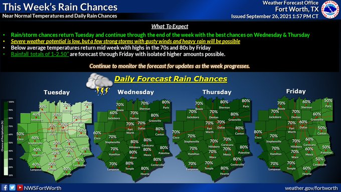
From the graphics on FWD tomorrow and Friday look good, but who knows. It changes a lot by the day. I ran the sprinkler.
0 likes
-
Brent
- S2K Supporter
- Posts: 37094
- Age: 35
- Joined: Sun May 16, 2004 10:30 pm
- Location: Tulsa Oklahoma
- Contact:
Re: Texas Fall 2021
If it's gonna be this humid it better come a flood
Also not impressed with the sunny weather today..
Also not impressed with the sunny weather today..
0 likes
#neversummer
-
ElectricStorm
- Category 5
- Posts: 4530
- Age: 23
- Joined: Tue Aug 13, 2019 11:23 pm
- Location: Skiatook, OK / Norman, OK
Re: Texas Fall 2021
I'm actually somewhat interested in the 6z SPC outlook. Rare for September, but both the NAM and HRRR show a solid line moving through OK/TX during the mid-afternoon/evening. Soundings look pretty bad for anything too strong. Any severe threat will be very very low, but there's at least a chance we can at least end up with a solid storm tomorrow. After over a month will no rain, I'll take anything at this point.
1 likes
I am in no way a professional. Take what I say with a grain of salt as I could be totally wrong. Please refer to the NHC, NWS, or SPC for official information.
Boomer Sooner!
Boomer Sooner!
Return to “USA & Caribbean Weather”
Who is online
Users browsing this forum: South Texas Storms and 144 guests