Probably means little in the long range, but the 12z EPS guidance at the 500 mb level mean has a trough coming down] and becomes cut off and digs down into the desert SW at day 12-13, becomes trapped under ridging
The 500 mb pattern after the 10th or so is starting to look a bit more interesting
Texas Fall 2023
Moderator: S2k Moderators
Forum rules

The posts in this forum are NOT official forecast and should not be used as such. They are just the opinion of the poster and may or may not be backed by sound meteorological data. They are NOT endorsed by any professional institution or STORM2K.
-
Stratton23
- Category 2

- Posts: 558
- Joined: Fri Jul 21, 2023 10:59 pm
- Location: College Station, Tx
Re: Texas Fall 2023
2 likes
-
Brent
- S2K Supporter

- Posts: 37099
- Age: 35
- Joined: Sun May 16, 2004 10:30 pm
- Location: Tulsa Oklahoma
- Contact:
Re: Texas Fall 2023
Stratton23 wrote:Probably means little in the long range, but the 12z EPS guidance at the 500 mb level mean has a trough coming down] and becomes cut off and digs down into the desert SW at day 12-13, becomes trapped under ridging
The 500 mb pattern after the 10th or so is starting to look a bit more interesting
Our met up here has been consistently talking about that timeframe. Actually predicted our first snow back when we couldn't get rid of the heat
0 likes
#neversummer
-
tajmahal
- Tropical Storm

- Posts: 168
- Age: 66
- Joined: Tue Jan 10, 2012 10:09 am
- Location: Austin, TX area & eastern Africa
Re: Texas Fall 2023
Brent wrote:Stratton23 wrote:Probably means little in the long range, but the 12z EPS guidance at the 500 mb level mean has a trough coming down] and becomes cut off and digs down into the desert SW at day 12-13, becomes trapped under ridging
The 500 mb pattern after the 10th or so is starting to look a bit more interesting
Our met up here has been consistently talking about that timeframe. Actually predicted our first snow back when we couldn't get rid of the heatI might laugh if hes right tbh. Some of his predictions haven't gone so well so to see it even sort of showing up
Which met?
0 likes
-
Brent
- S2K Supporter
- Posts: 37099
- Age: 35
- Joined: Sun May 16, 2004 10:30 pm
- Location: Tulsa Oklahoma
- Contact:
Re: Texas Fall 2023
tajmahal wrote:Brent wrote:Stratton23 wrote:Probably means little in the long range, but the 12z EPS guidance at the 500 mb level mean has a trough coming down] and becomes cut off and digs down into the desert SW at day 12-13, becomes trapped under ridging
The 500 mb pattern after the 10th or so is starting to look a bit more interesting
Our met up here has been consistently talking about that timeframe. Actually predicted our first snow back when we couldn't get rid of the heat
Which met?
Mike Collier
Another one has predicted snow in December but didn't have a date
0 likes
#neversummer
-
tajmahal
- Tropical Storm
- Posts: 168
- Age: 66
- Joined: Tue Jan 10, 2012 10:09 am
- Location: Austin, TX area & eastern Africa
Re: Texas Fall 2023
Brent wrote:tajmahal wrote:Brent wrote:
Our met up here has been consistently talking about that timeframe. Actually predicted our first snow back when we couldn't get rid of the heat
Which met?
Mike Collier
Another one has predicted snow in December but didn't have a date
Chris Nunley has a Ph.D. in meteorology. The others don't.
0 likes
-
ElectricStorm

- Category 5

- Posts: 4541
- Age: 23
- Joined: Tue Aug 13, 2019 11:23 pm
- Location: Skiatook, OK / Norman, OK
Re: Texas Fall 2023
tajmahal wrote:Brent wrote:tajmahal wrote:
Which met?
Mike Collier
Another one has predicted snow in December but didn't have a date
Chris Nunley has a Ph.D. in meteorology. The others don't.
And that matters how?
You don't have to have a PhD to be a good met
12 likes
I am in no way a professional. Take what I say with a grain of salt as I could be totally wrong. Please refer to the NHC, NWS, or SPC for official information.
Boomer Sooner!
Boomer Sooner!
-
ElectricStorm
- Category 5
- Posts: 4541
- Age: 23
- Joined: Tue Aug 13, 2019 11:23 pm
- Location: Skiatook, OK / Norman, OK
Re: Texas Fall 2023
0z HRRR still looks a little messy in the enhanced risk area for tomorrow, although it does continue to show a few dangerous cells. We'll see how much morning convection ends up affecting the later cells. I don't really see this being a major event, could have a few weak tornadoes but I doubt we see anything intense. Hopefully everything avoids populated areas.
Radar coverage might be an issue though. Looks like KHGX is down for maintenance which is going to leave a massive radar hole right over the main threat area.
On another note, looks like this could end up being a nice rain/thunderstorm event here in C OK. Not expecting anything severe though but I'll certainly take a nice storm.
Last edited by ElectricStorm on Wed Nov 29, 2023 11:23 pm, edited 1 time in total.
1 likes
I am in no way a professional. Take what I say with a grain of salt as I could be totally wrong. Please refer to the NHC, NWS, or SPC for official information.
Boomer Sooner!
Boomer Sooner!
-
Brent
- S2K Supporter
- Posts: 37099
- Age: 35
- Joined: Sun May 16, 2004 10:30 pm
- Location: Tulsa Oklahoma
- Contact:
Re: Texas Fall 2023
tajmahal wrote:Brent wrote:tajmahal wrote:
Which met?
Mike Collier
Another one has predicted snow in December but didn't have a date
Chris Nunley has a Ph.D. in meteorology. The others don't.
Not sure anyone cares his job is in danger because KTUL where he works is outsourcing the news to OKC soon. They literally fired nearly everyone already. He literally just got hired on too since the summer... It's been a huge story up here and nobody is happy about it. Like I haven't even seen him talk about winter because of the job fears
Not to get off topic but the Houston radar is down for the severe tomorrow

Last edited by Brent on Wed Nov 29, 2023 11:58 pm, edited 1 time in total.
1 likes
#neversummer
-
Tireman4

- S2K Supporter
- Posts: 5674
- Age: 58
- Joined: Fri Jun 30, 2006 1:08 pm
- Location: Humble, Texas
- Contact:
Re: Texas Fall 2023
This has the potential to be a rough one in our part of the state. Stay tuned.
0 likes
-
CaptinCrunch

- S2K Supporter
- Posts: 8575
- Age: 56
- Joined: Mon Nov 03, 2003 4:33 pm
- Location: Lake Worth, TX (Tarrant Co.)
Re: Texas Fall 2023
ElectricStorm wrote:tajmahal wrote:Brent wrote:
Mike Collier
Another one has predicted snow in December but didn't have a date
Chris Nunley has a Ph.D. in meteorology. The others don't.
And that matters how?
You don't have to have a PhD to be a good met
The late GREAT Harold Taff didn't have a PHd in metorology, and that man was so accurate you could set your watch to him (weather wise)
9 likes
-
CaptinCrunch
- S2K Supporter
- Posts: 8575
- Age: 56
- Joined: Mon Nov 03, 2003 4:33 pm
- Location: Lake Worth, TX (Tarrant Co.)
Re: Texas Fall 2023
accidental post
Last edited by CaptinCrunch on Thu Nov 30, 2023 8:56 am, edited 1 time in total.
0 likes
Re: Texas Fall 2023
CaptinCrunch wrote:ElectricStorm wrote:tajmahal wrote:
Chris Nunley has a Ph.D. in meteorology. The others don't.
And that matters how?
You don't have to have a PhD to be a good met
The late GREAT Harold Taff didn't have a PHd in metorology, and that man was so accurate you could set your watch to him (weather wise)
Taft was great. And his local rival, Troy Dungan, wasn't a degreed met either. Both of them were terrific at what they did, in different ways. I loved that Harold was like our resident met historian. He'd usually start his weathercast with some tidbit of local "on this day" fact. And a lot of times he was alive and living in the area to recount it. Like cars driving on Lake Worth during the 1949 freeze, or watching the Dallas tornado from 1957 from the east side of FTW. Troy's iconic bow tie and spot reporting were great. During an ice storm he'd be out there in the thick of it giving the weather broadcast. Good times, and looking back I realize how spoiled we were in DFW at that time to have such great coverage.
6 likes
-
Tireman4
- S2K Supporter
- Posts: 5674
- Age: 58
- Joined: Fri Jun 30, 2006 1:08 pm
- Location: Humble, Texas
- Contact:
Re: Texas Fall 2023
Well, I love Tom Skilling of WGN. Back to weather...lol
000
FXUS64 KHGX 301130
AFDHGX
Area Forecast Discussion
National Weather Service Houston/Galveston TX
530 AM CST Thu Nov 30 2023
...New AVIATION...
.SYNOPSIS...
Issued at 354 AM CST Thu Nov 30 2023
Rain and thunderstorms are expected this morning and afternoon. Some
of these thunderstorms could become strong to severe. Though there
remains uncertainty regarding whether or not we will have sufficient
instability, the strong veering shear profile will create an
environment in which only modest instability could result in
isolated tornadoes. Tornadoes and damaging wind gusts are the
primary concern. Isolated large hail cannot be ruled out. In
addition, locally heavy rainfall could result in localized flooding,
particularly from I-10 south to the coast. The highest severe
weather risk will be from late morning through the afternoon.
Showers and storms could linger near the coast into the evening
hours.
&&
.SHORT TERM...
(Today through Friday Night)
Issued at 354 AM CST Thu Nov 30 2023
A negatively tilted mid/upper trough over the southwest CONUS will
push eastward today, ejecting an associated strong mid/upper jet
streak over Texas. The resulting LL cyclogenesis over NW Texas will
induce a S to SSW LL jet that will propagate eastward over our
region. Meanwhile, a surge of deep LL tropical moisture looms behind
a warm front that is pushing northward through the CWA this morning.
In addition to the large scale lift created by the primary trough,
shortwaves embedded in the mid/upper synoptic flow will introduce
additional lift to the region. In other words, there is a good
chance of showers and thunderstorms today. Given the strong
veering shear profile, we are concerned that some of these storms
could become strong to severe with the primary concerns being
tornadoes, damaging wind gusts, locally heavy rainfall, and
possibly large hail. So let`s dive into the details.
Coverage of showers and thunderstorms will increase from south to
north as an approaching shortwave enhances lift in an
increasingly moist environment. Meanwhile aloft, S to SSW 850MB
winds will continue to increase as the LL jet strengthens and
pushes eastward. By the 12Z-15Z time frame, 850MB winds could be
approaching 40 knots. RAP analysis shows elevated sfc CAPE
sneaking its way up the Texas Coast this morning. Therefore, we
cannot rule out isolated strong to severe thunderstorms pretty
early in the day over our southwestern counties near Matagorda Bay
if sufficient CAPE is able to push far enough north. Showers and
thunderstorms are possible during the morning commute elsewhere
but the highest risk of strong to severe thunderstorms will be
late morning through the afternoon and possibly lingering into the
early evening hours.
LL shear maximizes this afternoon. Bulk shear values are already
concerning enough, exceeding 50 knots this afternoon. But of
particular concern is the shear created by the 50+ knot LL jet. Fcst
soundings suggest sfc-1km shear exceeding 30 knots and possibly
exceeding 40 knots. This highly sheared and veering wind profile is
favorable for the development of supercells capable of producing a
tornado and damaging downdraft winds. The primary potential
inhibiting factors will be the morning shower and thunderstorm
activity, the lack luster lapse rates at the lowest levels, and
the potential for convection over Gulf to limit our CAPE potential
even further. Does early day rain and storms significantly
suppress later day CAPE? Do subpar LL lapse throw a wrench in our
helical updrafts? Does convection over perform offshore, depriving
inland thunderstorms of crucial energy? Or can the overall
dynamics of the system overcome these limitations? The answers to
these questions are uncertain. However, it will not take much
instability to result in isolated tornadoes today given the shear
parameters. Rain and thunderstorms will end from west to east
later today. It could take until sometime this evening for the
showers/storms to move offshore and east of our CWA. The risk of
severe weather is area wide. That being said, HREF ensembles have
been most aggressive with stronger thunderstorms between the coast
and I-10 in recent runs. It will be interesting to see if this
trend holds.
In addition to the severe weather risk, locally heavy rainfall
resulting in localized flooding will be a concern. Rainfall rates
will be high within heavier showers and thunderstorms. CAMs guidance
suggest widespread 1 to 3 inches of rainfall with locally over 6
inches possible. Though locally heavy rainfall is an area wide
concern, the best chance of seeing locally heavier totals is over
our southern and coastal counties where training cells are most
likely.
Areas of fog are possible tonight in the wake of the system. The
front is expected to stall offshore tomorrow morning before pushing
back northward, introducing another chance of showers and a few
thunderstorms on Friday. Best chance of rain on Friday will be over
our southern and coastal counties. Couldn`t rule out an isolated
stronger thunderstorm or two near the coast on Friday.
Self
&&
.LONG TERM...
(Saturday through Wednesday)
Issued at 304 AM CST Thu Nov 30 2023
With some lingering moisture possibly persisting, will keep some low
rain chances in Saturday`s forecast (higher southeast and off the
coast, lower to nil northwest and west areas). A drying airmass
(surface and high pressure building into the state) and a transition
from a southwest flow aloft to a west to northwest flow aloft will
bring dry weather back to the area will cool nights and mild days
(lows in the 40s/50s and highs in the 60s/70s) Sunday through
Wednesday.
42
&&
.AVIATION...
(12Z TAF Issuance)
Issued at 521 AM CST Thu Nov 30 2023
The primary focus today will be the high chance of SHRA/TSRA. A
few TS could become strong to severe. Latest trends support TSRA
more over our southern terminals. We no longer have TSRA
prevailing north of I-10. However, we left TSRA TEMPO groups in
all terminals north of I-10 except CLL. Primary time frame of
concern for heavy TS will be late morning through the afternoon.
We will also need to monitor wind shear, particularly near UTS
during the late morning hours. Model blend used for our wind shear
grids did not show a long enough period of shear to warrant WS in
the prevailing. But certainly something to monitor. Any heavy
TS/SH could drop cigs/vis to LIFR. Speaking of cigs, a mix of IFR
and MVFR is likely today. Given what we are seeing in the soundings,
we are leaningn towards more IFR for now. Once the TS/SH activity
moves east and offshore, the concern will shift reduced vis/cigs.
We have IFR conditions tonight but much of the guidance suggest
LIFR.
&&
.MARINE...
Issued at 304 AM CST Thu Nov 30 2023
Today is definitely not a good day for boaters to be out on the
waters. Strengthening onshore winds and building seas are expected
today as a storm system organizes and moves across the state. Buoy
42019 has southeast winds increasing early this morning with gusts
close to 30 knots, and similar speeds should spread closer to the
coast/bays as the day progresses today. Small Craft Advisories and
Gale Warnings will be in effect as seas rise to 6 to 9 feet
nearshore and 10 to 14 feet offshore while winds gusts up to gale
force. These hazardous marine conditions could linger into the late
evening and possibly into parts of the overnight hours before the
gradient starts to relax resulting in lowering winds and seas.
Periods of showers and thunderstorms can be expected too with some
storms possibly becoming strong or severe. With the storm system`s
front expected to stall somewhere near/along the coast, we could see
some fog development in a late Thursday night through Saturday time
period. Conditions will improve over the weekend and into the start
of next week as the offshore flow weakens and seas come down.
42
&&
.CLIMATE...
Issued at 304 AM CST Thu Nov 30 2023
Here are today`s rainfall records (11/30) for our five major climate
sites.
CLL - 1.91 inches set in 1968
IAH - 1.41 inches set in 1968
HOU - 1.05 inches set in 1982
GLS - 1.40 inches set in 1921
PSX - 1.28 inches set in 1968
42
&&
.PRELIMINARY POINT TEMPS/POPS...
College Station (CLL) 70 55 68 50 / 90 20 10 20
Houston (IAH) 71 64 72 59 / 90 50 30 40
Galveston (GLS) 70 64 70 62 / 90 60 40 50
&&
.HGX WATCHES/WARNINGS/ADVISORIES...
TX...High Rip Current Risk from 9 AM CST this morning through this
evening for TXZ436>439.
GM...Small Craft Should Exercise Caution until 9 AM CST this morning
for GMZ330-335.
Small Craft Should Exercise Caution this evening for GMZ330-335.
Small Craft Advisory from 9 AM this morning to 9 PM CST this
evening for GMZ330-335.
Small Craft Advisory until 6 AM CST Friday for GMZ350-355.
Small Craft Advisory until 9 AM CST this morning for GMZ370-375.
Small Craft Advisory from midnight tonight to 6 AM CST Friday
for GMZ370-375.
Gale Warning from 9 AM this morning to midnight CST tonight for
GMZ370-375.
&&
$$
SHORT TERM...Self
LONG TERM....Adams
AVIATION...Self
MARINE...Adams
0 likes
-
HockeyTx82
- S2K Supporter
- Posts: 1991
- Joined: Tue Oct 27, 2009 11:17 am
- Location: Ponder, TX
Re: Texas Fall 2023
tajmahal wrote:Brent wrote:tajmahal wrote:
Which met?
Mike Collier
Another one has predicted snow in December but didn't have a date
Chris Nunley has a Ph.D. in meteorology. The others don't.
Not sure if your trolling here or just making a comment but like others said, what does it matter? What metric do you gauge intelligence on to allow someone to have an opinion on something?
What certifications or degrees do you have for weather?
I'm sure this post will get moderated and removed, but your negatively and somewhat perceived arrogance is very tiring. This is a fun board where we as amateurs and some certified professionals (perhaps not good enough for some if they don't have a PhD) come together to talk about the weather. Not to measure or question someone's intelligence.
The Dunning–Kruger effect.......
https://youtu.be/RAlI0pbMQiM?feature=shared
Last edited by HockeyTx82 on Thu Nov 30, 2023 11:30 am, edited 1 time in total.
6 likes
Don't hold me accountable for anything I post on this forum. Leave the real forecasting up to the professionals.
Location: Ponder, TX (all observation posts are this location unless otherwise noted)
Location: Ponder, TX (all observation posts are this location unless otherwise noted)
-
Iceresistance

- Category 5
- Posts: 8913
- Age: 20
- Joined: Sat Oct 10, 2020 9:45 am
- Location: Tecumseh, OK/Norman, OK
Re: Texas Fall 2023
Do those big storms over the GoM have any implications for the severe weather possibility later today for Houston?
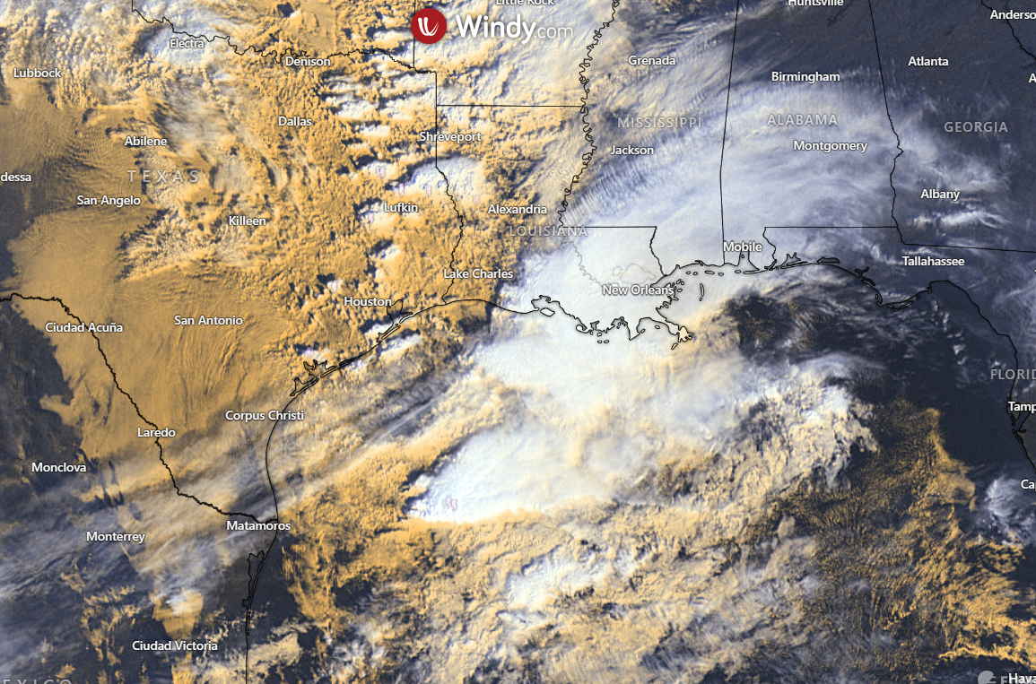
https://s5.gifyu.com/images/SRBCN.png
https://s5.gifyu.com/images/SRBCN.png
1 likes
Bill 2015 & Beta 2020
Winter 2020-2021
All observations are in Tecumseh, OK unless otherwise noted.
Winter posts are focused mainly for Oklahoma & Texas.
Take any of my forecasts with a grain of salt, refer to the NWS, SPC, and NHC for official information
Never say Never with weather! Because ANYTHING is possible!
Winter 2020-2021
All observations are in Tecumseh, OK unless otherwise noted.
Winter posts are focused mainly for Oklahoma & Texas.
Take any of my forecasts with a grain of salt, refer to the NWS, SPC, and NHC for official information
Never say Never with weather! Because ANYTHING is possible!
-
jasons2k

- Storm2k Executive

- Posts: 8076
- Age: 50
- Joined: Wed Jul 06, 2005 12:32 pm
- Location: The Woodlands, TX
Texas Fall 2023
Harold has the gold standard for TV mets, him along with Roy Leep of WTVT. I’m pretty sure WTVT recruited Roy from Florida State before he earned his degree, but he went on to build one of most pioneering TV Weather Offices in the nation, with many “firsts” in the industry, similar to KXAS.
Jeff Linder has his B.S. from A&M and is one of the most trusted mets out there. Here is his morning discussion:
Changes:
Few changes to the severe weather risk…this risk remains conditional on enough instability over the area to utilize favorable wind shear values.
Heavy rainfall threat has increased some…WPC has now included a slight risk of flash flooding over the coastal areas of SE TX.
Timing remains the same with the most active weather from 900am-400pm….although storms may linger south of I-10 into the evening hours.
Discussion:
A strong upper level storm system will move across Texas today with low pressure forming over NW TX and moving eastward toward northern Louisiana. In response to the lowering surface pressures a strong low level jet of 40-50kts is currently developing over SE TX and will help transport copious moisture into the region. Low level winds veer and increase with height over the region and are supportive of rotating updrafts and supercell production from mid to late morning into the afternoon hours. There still remains questions on how much instability can work into the region along and behind the northeastward moving warm front. Additionally, the lapse rate or the rate at which an air parcel will rise vertically are not overly impressive and much of the area will likely be covered with clouds and ongoing showers/thunderstorms which may help to limit the destabilization. Also there has been a fairly large area of deep convection over the NW Gulf this morning which may “rob” the incoming instability some. However, you cannot ignore the highly sheared air mass over the region and if a few cells can take the full potential of that shear an isolated tornado is certainly possible. The overall setup looks more like a “usual” cool season severe weather event for the southern US/Gulf coast with any tornadoes likely being small, short lived and generally on the weaker side. SPC has maintained the enhanced risk area (3 out of 5) surrounded by a slight risk (2 out of 5) for the region today and the 5-14% tornado probabilities within 25 miles of a point.
While much focus has been on the tornado threat…there will also be a damaging wind and large hail potential with the hail potential likely the least of the threats. Given the wind energy aloft it will not take much to bring some of those stronger winds just off the surface down…so even a stronger shower may produce 40-50mph winds today. Additionally, gradient winds of 25-30mph with a few higher gusts will be common over the area for much of the day with the coastal locations seeing the stronger winds.
Heavy Rainfall:
Trend over the last 24 hours has been to increase rainfall amounts with the potential for storm clustering and cell training in southwest to northeast bands. Overall moisture profiles will be high for late November with PWS of 1.6-1.7 inches over the area and when combined with a strong onshore feed of moisture and favorable lift widespread showers and thunderstorms are likely. Some of the higher resolution guidance does show some banding and training of storms this afternoon into the evening hours for areas mainly south of I-10 and around Galveston Bay (SE Harris, Liberty, Chambers, Galveston, Brazoria Counties).
Rainfall amounts of 1-3 inches appear to be common today with higher isolated totals of 4-5 inches especially for areas south of I-10 where activity may linger into the evening hours.
Soils are generally dry over the area, but hourly rainfall rates of 1-2 inches per hour may result in some street flooding at the usual flood prone locations.
Surface front sags off the coast tonight into early Friday, but active southwest flow aloft looks to bring additional disturbances across the region on Friday with showers and thunderstorms expanding inland toward the I-10 corridor.


Jeff Lindner
Director Hydrologic Operations Division/Meteorologist
Harris County Flood Control District
9900 Northwest Freeway | Houston, Texas 77092
346-286-4000 (main) | 346-286-4165 (direct) | 281-924-2091 (cell)
jeff.lindner@hcfcd.org | Twitter: @jefflindner1
Jeff Linder has his B.S. from A&M and is one of the most trusted mets out there. Here is his morning discussion:
Changes:
Few changes to the severe weather risk…this risk remains conditional on enough instability over the area to utilize favorable wind shear values.
Heavy rainfall threat has increased some…WPC has now included a slight risk of flash flooding over the coastal areas of SE TX.
Timing remains the same with the most active weather from 900am-400pm….although storms may linger south of I-10 into the evening hours.
Discussion:
A strong upper level storm system will move across Texas today with low pressure forming over NW TX and moving eastward toward northern Louisiana. In response to the lowering surface pressures a strong low level jet of 40-50kts is currently developing over SE TX and will help transport copious moisture into the region. Low level winds veer and increase with height over the region and are supportive of rotating updrafts and supercell production from mid to late morning into the afternoon hours. There still remains questions on how much instability can work into the region along and behind the northeastward moving warm front. Additionally, the lapse rate or the rate at which an air parcel will rise vertically are not overly impressive and much of the area will likely be covered with clouds and ongoing showers/thunderstorms which may help to limit the destabilization. Also there has been a fairly large area of deep convection over the NW Gulf this morning which may “rob” the incoming instability some. However, you cannot ignore the highly sheared air mass over the region and if a few cells can take the full potential of that shear an isolated tornado is certainly possible. The overall setup looks more like a “usual” cool season severe weather event for the southern US/Gulf coast with any tornadoes likely being small, short lived and generally on the weaker side. SPC has maintained the enhanced risk area (3 out of 5) surrounded by a slight risk (2 out of 5) for the region today and the 5-14% tornado probabilities within 25 miles of a point.
While much focus has been on the tornado threat…there will also be a damaging wind and large hail potential with the hail potential likely the least of the threats. Given the wind energy aloft it will not take much to bring some of those stronger winds just off the surface down…so even a stronger shower may produce 40-50mph winds today. Additionally, gradient winds of 25-30mph with a few higher gusts will be common over the area for much of the day with the coastal locations seeing the stronger winds.
Heavy Rainfall:
Trend over the last 24 hours has been to increase rainfall amounts with the potential for storm clustering and cell training in southwest to northeast bands. Overall moisture profiles will be high for late November with PWS of 1.6-1.7 inches over the area and when combined with a strong onshore feed of moisture and favorable lift widespread showers and thunderstorms are likely. Some of the higher resolution guidance does show some banding and training of storms this afternoon into the evening hours for areas mainly south of I-10 and around Galveston Bay (SE Harris, Liberty, Chambers, Galveston, Brazoria Counties).
Rainfall amounts of 1-3 inches appear to be common today with higher isolated totals of 4-5 inches especially for areas south of I-10 where activity may linger into the evening hours.
Soils are generally dry over the area, but hourly rainfall rates of 1-2 inches per hour may result in some street flooding at the usual flood prone locations.
Surface front sags off the coast tonight into early Friday, but active southwest flow aloft looks to bring additional disturbances across the region on Friday with showers and thunderstorms expanding inland toward the I-10 corridor.
Jeff Lindner
Director Hydrologic Operations Division/Meteorologist
Harris County Flood Control District
9900 Northwest Freeway | Houston, Texas 77092
346-286-4000 (main) | 346-286-4165 (direct) | 281-924-2091 (cell)
jeff.lindner@hcfcd.org | Twitter: @jefflindner1
0 likes
-
bubba hotep

- S2K Supporter
- Posts: 5457
- Joined: Wed Dec 28, 2016 1:00 am
- Location: Collin County Texas
Re: Texas Fall 2023
Iceresistance wrote:Do those big storms over the GoM have any implications for the severe weather possibility later today for Houston?
https://s5.gifyu.com/images/SRBCN.png
https://s5.gifyu.com/images/SRBCN.png
I haven't paid a lot of attention to this event, but you can see the HRRR shifting the QPF max SE offshore.
0 likes
Winter time post are almost exclusively focused on the DFW area.
-
snowballzzz

- Tropical Storm
- Posts: 126
- Age: 30
- Joined: Fri Dec 15, 2017 8:50 am
- Location: Sunset, TX and Tulsa, OK
Re: Texas Fall 2023
Brent wrote:tajmahal wrote:Brent wrote:
Our met up here has been consistently talking about that timeframe. Actually predicted our first snow back when we couldn't get rid of the heat
Which met?
Mike Collier
Another one has predicted snow in December but didn't have a date
Mike predicted an early December snowfall but claimed the very light dusting last week as the first snowfall
I am actually in Tulsa on and off the the next 8 months, so I'm looking forward to some winter weather. Not quite sure if we will see that until January. Looks like above normal temps over the next few weeks.
0 likes
-
Edwards Limestone

- S2K Supporter
- Posts: 338
- Age: 34
- Joined: Tue Dec 28, 2021 11:05 am
- Location: Smithson Valley, TX
Re: Texas Fall 2023
I put taj on ignore and my board experience has been much more pleasant thus far. No room for trolls here.
I've been lurking here for over 10 years and it'd be a shame to let some rogue poster ruin the awesome camaraderie y'all have cultivated here.
Hope everyone stays safe in SE TX today!!
I've been lurking here for over 10 years and it'd be a shame to let some rogue poster ruin the awesome camaraderie y'all have cultivated here.
Hope everyone stays safe in SE TX today!!
Last edited by Edwards Limestone on Thu Nov 30, 2023 11:35 am, edited 1 time in total.
11 likes
The above post is NOT an official forecast and should not be used as such. It is just the opinion of the poster and may or may not be backed by sound meteorological data. It is NOT endorsed by any professional institution including Storm2k. For official information, please refer to NWS products.
Re: Texas Fall 2023
Edwards Limestone wrote:I put taj on ignore and my board experience has been much more pleasant thus far. No room for trolls here.
Never knew that was an option. And I've been on here over a decade. Thanks.
6 likes
Return to “USA & Caribbean Weather”
Who is online
Users browsing this forum: No registered users and 155 guests