Really hope the eclipse will be cloud-free since we are entering a more rainy pattern.
There won't be another total eclipse here for 300 years.
Texas Spring 2024
Moderator: S2k Moderators
Forum rules

The posts in this forum are NOT official forecast and should not be used as such. They are just the opinion of the poster and may or may not be backed by sound meteorological data. They are NOT endorsed by any professional institution or STORM2K.
-
rwfromkansas
- Category 5

- Posts: 2176
- Joined: Sat Aug 27, 2005 12:47 am
- Location: North Fort Worth
Re: Texas Spring 2024
3 likes
Re: Texas Spring 2024
rwfromkansas wrote:Really hope the eclipse will be cloud-free since we are entering a more rainy pattern.
There won't be another total eclipse here for 300 years.
Wife and I are going to the Chicken N Pickle restaurant in Grand Prairie. It's throwing an eclipse party and we are taking the afternoon off. It's free but probably will be packed. Margarita specials also.
2 likes
-
Brent
- S2K Supporter

- Posts: 37099
- Age: 35
- Joined: Sun May 16, 2004 10:30 pm
- Location: Tulsa Oklahoma
- Contact:
Re: Texas Spring 2024
rwfromkansas wrote:Really hope the eclipse will be cloud-free since we are entering a more rainy pattern.
There won't be another total eclipse here for 300 years.
Lol I've been concerned about it being in April for a long time now but same
I'm probably gonna head down to some rural area towards the Texas border assuming the weather is good
1 likes
#neversummer

Re: Texas Spring 2024
Brent wrote:rwfromkansas wrote:Really hope the eclipse will be cloud-free since we are entering a more rainy pattern.
There won't be another total eclipse here for 300 years.
Lol I've been concerned about it being in April for a long time now but same
I'm probably gonna head down to some rural area towards the Texas border assuming the weather is good
I was lucky enough to be in Shanghai in 2009 for a total solar eclipse over the city. Weather was overcast and slightly rainy, but the experience was still amazing.
2 likes
-
ElectricStorm

- Category 5
- Posts: 4542
- Age: 23
- Joined: Tue Aug 13, 2019 11:23 pm
- Location: Skiatook, OK / Norman, OK
Re: Texas Spring 2024
Sunday could be a pretty big severe weather event if moisture ends up a bit better than current model runs. I think the slight risk will also be expanded east a bit. Setup looks pretty good overall.
1 likes
I am in no way a professional. Take what I say with a grain of salt as I could be totally wrong. Please refer to the NHC, NWS, or SPC for official information.
Boomer Sooner!
Boomer Sooner!
-
txtwister78

- Category 5
- Posts: 1011
- Joined: Wed Jan 30, 2019 12:56 pm
- Location: San Antonio
Re: Texas Spring 2024
ElectricStorm wrote:Sunday could be a pretty big severe weather event if moisture ends up a bit better than current model runs. I think the slight risk will also be expanded east a bit. Setup looks pretty good overall.
I think the one parameter that may keep this on the lower scale of things is available instability. Right now, that looks minimal at best. Lift and shear obviously won't be an issue with this system ejecting out and so I would lean more toward a quick linear based event as opposed to an organized/higher end supercell driven severe weather event late Sunday. If this were late April or May then we'd likely be discussing a higher threat, but these cooler shots of air have helped to minimize the higher end threats thus far. That will obviously change as we move later into spring.
Monday could end up being the bigger severe weather day off to the east where moisture and instability appear to be more favorable.
1 likes
-
bubba hotep

- S2K Supporter
- Posts: 5459
- Joined: Wed Dec 28, 2016 1:00 am
- Location: Collin County Texas
Re: Texas Spring 2024
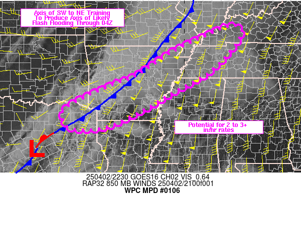
Mesoscale Precipitation Discussion 0106
NWS Weather Prediction Center College Park MD
508 PM EDT Thu Mar 21 2024
Areas affected...Southern Oklahoma to Northern Texas
Concerning...Heavy rainfall...Flash flooding possible
Valid 212107Z - 220245Z
Summary...Isolated flash flooding is possible across portions of
southern Oklahoma into northern Texas as a shortwave trough moves
eastward near the Red River and convection begins to grow upscale
in coverage and intensity this afternoon. Localized rainfall
totals of 2 to 4 inches remains possible where cell motions are
reduced close to the ejecting trough/low.
Discussion...Radar showed convection beginning to grow either side
of the Red River in proximity in the vicinity of a pair of
shortwave troughs, a weak dryline in the area, and a
quasi-stationary front located to the north.
The HRRR runs from late this morning and this afternoon have been
showing run to run differences in placement of the heaviest
rainfall...but a consistent theme has been for the axis of
heaviest rain to be along and immediately south of the track of
the trough where greater surface-based instability should result
from better daytime heating/steeper low/mid level lapse rates.
Surface flow is fairly weak into the region and 850 mb flow is
modest...15 to 20 kts at best as shown by latest VWPs from the
Gulf coast region northward into central/eastern Texas...but the
flow was favoring moisture transport ahead of the trough/low.
Flash flood guidance was generally at or above 2.5 inches per hour
and closer to 3 inches per 3 hours hour across MPD area. Thinking
is that localized maximum rainfall amounts of 2 to 4 inches are
possible should the cells slow down in response to the approach of
the upper system...so instances of flash flooding rainfall may
occur but should be isolated in coverage.
Bann
ATTN...WFO...FWD...OUN...SJT...
ATTN...RFC...ABRFC...WGRFC...NWC...
0 likes
Winter time post are almost exclusively focused on the DFW area.
-
rwfromkansas
- Category 5
- Posts: 2176
- Joined: Sat Aug 27, 2005 12:47 am
- Location: North Fort Worth
Re: Texas Spring 2024
Surprise severe storm to the west of DFW. I have been busy so didn't know this was coming.
0 likes
Re: Texas Spring 2024
3.75” with the last system over the weekend and another 3.75” today. Hit the jackpot.
3 likes
-
Texas Snowman

- Storm2k Moderator

- Posts: 6011
- Joined: Fri Jan 25, 2008 11:29 am
- Location: Denison, Texas
Re: Texas Spring 2024
1 likes
The above post and any post by Texas Snowman is NOT an official forecast and should not be used as such. It is just the opinion of the poster and may or may not be backed by sound meteorological data. It is NOT endorsed by any professional institution including storm2k.org. For official information, please refer to NWS products.
-
bubba hotep
- S2K Supporter
- Posts: 5459
- Joined: Wed Dec 28, 2016 1:00 am
- Location: Collin County Texas
Re: Texas Spring 2024
Awesome!
0 likes
Winter time post are almost exclusively focused on the DFW area.
-
South Texas Storms

- Professional-Met

- Posts: 4007
- Joined: Thu Jun 24, 2010 12:28 am
- Location: Houston, TX
Re: Texas Spring 2024
Just had a lot of quarter size hail here in northwest Houston. Quite rare here.
1 likes
-
txtwister78
- Category 5
- Posts: 1011
- Joined: Wed Jan 30, 2019 12:56 pm
- Location: San Antonio
Re: Texas Spring 2024
Big thunderstorm moving through San Antonio with some big hail on the NW side.
1 likes
-
txtwister78
- Category 5
- Posts: 1011
- Joined: Wed Jan 30, 2019 12:56 pm
- Location: San Antonio
-
Texas Snowman
- Storm2k Moderator
- Posts: 6011
- Joined: Fri Jan 25, 2008 11:29 am
- Location: Denison, Texas
Re: Texas Spring 2024

1 likes
The above post and any post by Texas Snowman is NOT an official forecast and should not be used as such. It is just the opinion of the poster and may or may not be backed by sound meteorological data. It is NOT endorsed by any professional institution including storm2k.org. For official information, please refer to NWS products.
-
jasons2k

- Storm2k Executive

- Posts: 8076
- Age: 50
- Joined: Wed Jul 06, 2005 12:32 pm
- Location: The Woodlands, TX
Re: Texas Spring 2024
Special Weather Statement
National Weather Service Houston/Galveston TX
1158 PM CDT Thu Mar 21 2024
Inland Brazoria TX-Waller TX-Grimes TX-Wharton TX-Inland Harris TX-
...STRONG THUNDERSTORMS WILL IMPACT NORTHEASTERN WHARTON... SOUTHEASTERN AUSTIN...SOUTHEASTERN GRIMES...NORTHERN FORT BEND... SOUTHWESTERN MONTGOMERY...NORTHERN BRAZORIA...WALLER AND WESTERN HARRIS COUNTIES THROUGH 1245 AM CDT...
At 1158 PM CDT, Doppler radar was tracking strong thunderstorms along a line extending from 13 miles west of Huntsville to near Beasley. Movement was west at 45 mph.
HAZARD...Wind gusts up to 50 mph and pea size hail.
SOURCE...Radar indicated.
IMPACT...Gusty winds could knock down tree limbs and blow around unsecured objects. Minor hail damage to vegetation is possible.
Locations impacted include... Sugar Land, Missouri City, Conroe, Rosenberg, Stafford, Bellaire, West University Place, Katy, Richmond, Tomball, Jersey Village, Hempstead, Prairie View, Brookshire, Hunters Creek Village, Bunker Hill Village, Piney Point Village, Pinehurst, Spring Branch North, and The Woodlands.
PRECAUTIONARY/PREPAREDNESS ACTIONS...
If outdoors, consider seeking shelter inside a building.
&&
TIME...MOT...LOC 0458Z 315DEG 61KT 3064 9577 2944 9592
MAX HAIL SIZE...0.25 IN
MAX WIND GUST...50 MPH
$$
Self
0 likes
-
jasons2k
- Storm2k Executive
- Posts: 8076
- Age: 50
- Joined: Wed Jul 06, 2005 12:32 pm
- Location: The Woodlands, TX
Re: Texas Spring 2024
Special Weather Statement
National Weather Service Houston/Galveston TX
1220 AM CDT Fri Mar 22 2024
Inland Brazoria TX-Inland Harris TX-Fort Bend TX-Montgomery TX-
...STRONG THUNDERSTORMS WILL IMPACT CENTRAL FORT BEND...SOUTHERN MONTGOMERY...NORTHWESTERN BRAZORIA AND CENTRAL HARRIS COUNTIES THROUGH 100 AM CDT...
At 1220 AM CDT, Doppler radar was tracking strong thunderstorms along a line extending from near Shenandoah to near Bonney. Movement was east at 45 mph.
HAZARD...Wind gusts up to 50 mph.
SOURCE...Radar indicated.
IMPACT...Gusty winds could knock down tree limbs and blow around unsecured objects.
Locations impacted include... Pearland, Sugar Land, Missouri City, eastern Rosenberg, Alvin, Stafford, Bellaire, Humble, West University Place, Richmond, Galena Park, Tomball, Jacinto City, Jersey Village, Manvel, Hunters Creek Village, Bunker Hill Village, Piney Point Village, Pinehurst, and Downtown Houston.
PRECAUTIONARY/PREPAREDNESS ACTIONS...
If outdoors, consider seeking shelter inside a building.
&&
TIME...MOT...LOC 0520Z 269DEG 49KT 3024 9548 2934 9548
MAX HAIL SIZE...0.00 IN
MAX WIND GUST...50 MPH
$$
Self
0 likes
-
Iceresistance

- Category 5
- Posts: 8913
- Age: 20
- Joined: Sat Oct 10, 2020 9:45 am
- Location: Tecumseh, OK/Norman, OK
Re: Texas Spring 2024
I got 1.5 inches yesterday
2 likes
Bill 2015 & Beta 2020
Winter 2020-2021
All observations are in Tecumseh, OK unless otherwise noted.
Winter posts are focused mainly for Oklahoma & Texas.
Take any of my forecasts with a grain of salt, refer to the NWS, SPC, and NHC for official information
Never say Never with weather! Because ANYTHING is possible!
Winter 2020-2021
All observations are in Tecumseh, OK unless otherwise noted.
Winter posts are focused mainly for Oklahoma & Texas.
Take any of my forecasts with a grain of salt, refer to the NWS, SPC, and NHC for official information
Never say Never with weather! Because ANYTHING is possible!
-
ElectricStorm
- Category 5
- Posts: 4542
- Age: 23
- Joined: Tue Aug 13, 2019 11:23 pm
- Location: Skiatook, OK / Norman, OK
Re: Texas Spring 2024
Looking at models I think tornado potential for today is increasing, especially for SW OK. Should be an interesting day
1 likes
I am in no way a professional. Take what I say with a grain of salt as I could be totally wrong. Please refer to the NHC, NWS, or SPC for official information.
Boomer Sooner!
Boomer Sooner!
-
Iceresistance
- Category 5
- Posts: 8913
- Age: 20
- Joined: Sat Oct 10, 2020 9:45 am
- Location: Tecumseh, OK/Norman, OK
Re: Texas Spring 2024
The PDO is starting to become neutral
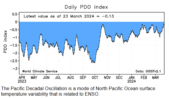
https://s12.gifyu.com/images/SVT9b.png
I got it from here
https://s2s.worldclimateservice.com/climatepanel/
https://s12.gifyu.com/images/SVT9b.png
I got it from here
https://s2s.worldclimateservice.com/climatepanel/
2 likes
Bill 2015 & Beta 2020
Winter 2020-2021
All observations are in Tecumseh, OK unless otherwise noted.
Winter posts are focused mainly for Oklahoma & Texas.
Take any of my forecasts with a grain of salt, refer to the NWS, SPC, and NHC for official information
Never say Never with weather! Because ANYTHING is possible!
Winter 2020-2021
All observations are in Tecumseh, OK unless otherwise noted.
Winter posts are focused mainly for Oklahoma & Texas.
Take any of my forecasts with a grain of salt, refer to the NWS, SPC, and NHC for official information
Never say Never with weather! Because ANYTHING is possible!
Return to “USA & Caribbean Weather”
Who is online
Users browsing this forum: CSpringer, Edwards Limestone, Google [Bot], rwfromkansas and 146 guests