A smashing success, am now 2-0 with totals.
Now off to clear out the storm cellar....
Texas Spring 2024
Moderator: S2k Moderators
Forum rules

The posts in this forum are NOT official forecast and should not be used as such. They are just the opinion of the poster and may or may not be backed by sound meteorological data. They are NOT endorsed by any professional institution or STORM2K.
-
Anti-freeze
- Tropical Low

- Posts: 49
- Joined: Tue Jan 02, 2024 8:26 pm
Re: Texas Spring 2024
3 likes
-
Anti-freeze
- Tropical Low
- Posts: 49
- Joined: Tue Jan 02, 2024 8:26 pm

Re: Texas Spring 2024
cheezyWXguy wrote:That was actually really cool, I did not expect it to actually get that dark. And happened to reach totality right in between clouds here in Dallas
I was at the Dallas Zoo and we got a really big break between small clouds for totality, which then proceeded to wipe away any remaining low-level cloud for the next half hour. I got excellent photos of totality and both partials.
2 likes
Irene '11 Sandy '12 Hermine '16 5/15/2018 Derecho Fay '20 Isaias '20 Elsa '21 Henri '21 Ida '21
I am only a meteorology enthusiast who knows a decent amount about tropical cyclones. Look to the professional mets, the NHC, or your local weather office for the best information.
I am only a meteorology enthusiast who knows a decent amount about tropical cyclones. Look to the professional mets, the NHC, or your local weather office for the best information.
-
bubba hotep

- S2K Supporter

- Posts: 5476
- Joined: Wed Dec 28, 2016 1:00 am
- Location: Collin County Texas
Re: Texas Spring 2024
18z 3k NAM says pull that Flood Watch westward a row of counties or two.

0 likes
Winter time post are almost exclusively focused on the DFW area.
-
Fifty Rock
- Tropical Low
- Posts: 48
- Joined: Mon Sep 11, 2023 10:08 am
- Location: Albany, Texas
Re: Texas Spring 2024
bubba hotep wrote:Subpar cell phone pics
https://pbs.twimg.com/media/GKqe-WmXgAAIPfr?format=jpg&name=large
https://pbs.twimg.com/media/GKqe-PrX0AA6HUR?format=jpg&name=large
Is that Bart Simpson in the first Picture..
0 likes
-
mmmmsnouts
- Tropical Depression

- Posts: 58
- Joined: Tue Sep 05, 2023 10:04 pm
- Location: Arlington, TX
Re: Texas Spring 2024
aspen wrote:I was at the Dallas Zoo and we got a really big break between small clouds for totality, which then proceeded to wipe away any remaining low-level cloud for the next half hour. I got excellent photos of totality and both partials.
All the dogs in my neighborhood started barking as soon as it got dark. I bet the zoo was absolutely wild.
0 likes
-
bubba hotep
- S2K Supporter
- Posts: 5476
- Joined: Wed Dec 28, 2016 1:00 am
- Location: Collin County Texas
Re: Texas Spring 2024
Just picked up some pea to nickle size hail with that storm.
1 likes
Winter time post are almost exclusively focused on the DFW area.
-
Brent
- S2K Supporter
- Posts: 37111
- Age: 35
- Joined: Sun May 16, 2004 10:30 pm
- Location: Tulsa Oklahoma
- Contact:
Re: Texas Spring 2024
Russellville where I was went from 80 to 68 during the eclipse 
Finally home after a traffic nightmare on 40... I didn't think a straight shot would be so bad. Apparently I was very wrong
Finally home after a traffic nightmare on 40... I didn't think a straight shot would be so bad. Apparently I was very wrong
1 likes
#neversummer
Re: Texas Spring 2024
mmmmsnouts wrote:aspen wrote:I was at the Dallas Zoo and we got a really big break between small clouds for totality, which then proceeded to wipe away any remaining low-level cloud for the next half hour. I got excellent photos of totality and both partials.
All the dogs in my neighborhood started barking as soon as it got dark. I bet the zoo was absolutely wild.
Shockingly, no. At least not where I was. I had my setup at the Picnic Ridge near the Maned Wolves and Toucans. Didn’t notice any of them acting up. I’d imagine the elephants and chimps went bananas, but I couldn’t hear them from my spot.
I could not have asked for a better turn of events today. This just showed yeah, the RGEM model is that good. It was the only one (or at least the first) showing mostly clear skies for DFW at eclipse time.
0 likes
Irene '11 Sandy '12 Hermine '16 5/15/2018 Derecho Fay '20 Isaias '20 Elsa '21 Henri '21 Ida '21
I am only a meteorology enthusiast who knows a decent amount about tropical cyclones. Look to the professional mets, the NHC, or your local weather office for the best information.
I am only a meteorology enthusiast who knows a decent amount about tropical cyclones. Look to the professional mets, the NHC, or your local weather office for the best information.
-
Anti-freeze
- Tropical Low
- Posts: 49
- Joined: Tue Jan 02, 2024 8:26 pm
Re: Texas Spring 2024
SPC just said golfball to softball sized hail in the storms approaching DFW from the west.
And there was a concerning notch/hook echo on the Palo Pinto storm that thankfully seems to have moderated in the last few minutes. With the continued talk of tornado possibilities overnight, guess I'll be up for awhile.
And there was a concerning notch/hook echo on the Palo Pinto storm that thankfully seems to have moderated in the last few minutes. With the continued talk of tornado possibilities overnight, guess I'll be up for awhile.
0 likes

Re: Texas Spring 2024
East Texas severe was a bust yesterday. Rainfall is living up to the hype, however. Had 4.5" when I woke up this morning. A lot of loud thunder last night!
1 likes
-
WacoWx
- Category 2

- Posts: 581
- Joined: Mon Dec 28, 2009 4:14 pm
- Location: NOT Waco, TX ----> Dallas, TX
Re: Texas Spring 2024
That thunder was very disruptive to my beauty sleep.
Got 2.51", though, so I will take it!
Got 2.51", though, so I will take it!
3 likes
-
Iceresistance

- Category 5

- Posts: 8915
- Age: 20
- Joined: Sat Oct 10, 2020 9:45 am
- Location: Tecumseh, OK/Norman, OK
Re: Texas Spring 2024
1 likes
Bill 2015 & Beta 2020
Winter 2020-2021
All observations are in Tecumseh, OK unless otherwise noted.
Winter posts are focused mainly for Oklahoma & Texas.
Take any of my forecasts with a grain of salt, refer to the NWS, SPC, and NHC for official information
Never say Never with weather! Because ANYTHING is possible!
Winter 2020-2021
All observations are in Tecumseh, OK unless otherwise noted.
Winter posts are focused mainly for Oklahoma & Texas.
Take any of my forecasts with a grain of salt, refer to the NWS, SPC, and NHC for official information
Never say Never with weather! Because ANYTHING is possible!
-
CaptinCrunch

- S2K Supporter
- Posts: 8576
- Age: 56
- Joined: Mon Nov 03, 2003 4:33 pm
- Location: Lake Worth, TX (Tarrant Co.)
Re: Texas Spring 2024
Anti-freeze wrote:SPC just said golfball to softball sized hail in the storms approaching DFW from the west.
And there was a concerning notch/hook echo on the Palo Pinto storm that thankfully seems to have moderated in the last few minutes. With the continued talk of tornado possibilities overnight, guess I'll be up for awhile.
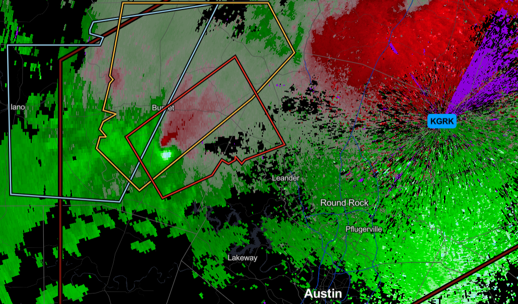
Storms out west are moving to the NE headed straight for Wichita Falls....Parker and Palo Pinto Co are currently storm/rain free.
https://radar.weather.gov/station/KFWS/standard
0 likes
-
rwfromkansas
- Category 5
- Posts: 2179
- Joined: Sat Aug 27, 2005 12:47 am
- Location: North Fort Worth
Re: Texas Spring 2024
Since this was supposed to be the big blob of rain and it's rather small and heading well north of DFW, I feel we are going to bust low significantly on rainfall.
I only have .50 in Tarrant. Nice group of storms last night though.
Warning for the future: Larry Cosgrove predicts an early summer starting in May and a shut-off rain spout.
Weatherford on west really need a lot more rain still...
I only have .50 in Tarrant. Nice group of storms last night though.
Warning for the future: Larry Cosgrove predicts an early summer starting in May and a shut-off rain spout.
Weatherford on west really need a lot more rain still...
0 likes
-
bubba hotep
- S2K Supporter
- Posts: 5476
- Joined: Wed Dec 28, 2016 1:00 am
- Location: Collin County Texas
Re: Texas Spring 2024
WPC highlights a large area, but the primary concern continues over areas that have already seen a lot of rain.
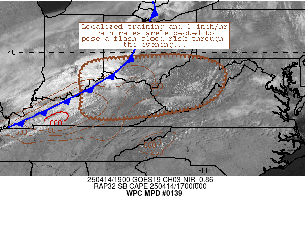
Mesoscale Precipitation Discussion 0139
NWS Weather Prediction Center College Park MD
1125 AM EDT Tue Apr 09 2024
Areas affected...Central and Eastern TX
Concerning...Heavy rainfall...Flash flooding likely
Valid 091525Z - 092125Z
SUMMARY...Very heavy showers and thunderstorms including concerns
for additional cell-training will continue across areas of central
and eastern TX. Additional areas of flash flooding are likely, and
locally significant flash flooding is possible.
DISCUSSION...The GOES-East IR satellite imagery shows an expansive
axis of cold-topped convection associated with very heavy showers
and thunderstorms focusing across areas of central and eastern TX,
with the more robust convective growth over the last hour seen
generally along a line from near Burnett through Waco and up into
the Corsicana area. Some rainfall rates with this activity are
reaching into the 2" to 3"/hour range.
The activity continues to locally organize and focus in response
to the nose of a moist southerly low-level jet of 30 to 40 kts
overrunning a quasi-stationary front generally oriented west/east
across the region. A well-defined and substantial pool of
instability is noted near and south of the front, which includes
MLCAPE values of 1500 to 2000+ J/kg across the Hill Country.
This moderate to strongly unstable airmass coupled with focused
low-level moisture convergence and increasingly divergent flow
aloft ahead of a deeper layer trough/closed low ejecting east into
the southern High Plains is expected to favor a continuation and
localized expansion of convective activity over the next few hours.
Many areas across northern and eastern TX have already seen heavy
rainfall and flash flooding early this morning, and additional
very heavy rainfall totals are expected over the next few hours
which may total as much as 4 to 6 inches with isolated heavier
amounts not out of the question where any cell-training occurs.
The greatest likelihood for this is along the aforementioned
corridor from near Burnett through Waco and into Corsicana.
Adjacent areas of central and eastern TX near and north of the
front are likely to see heavy rainfall as well with somewhat
lesser totals at least through mid-afternoon. Upstream convection
approaching from the TX Panhandle and northwest TX will also need
to be closely monitored as that activity associated with the
leading edge of the upper-trough will promote eventually a renewed
heavy rainfall/convective threat to the Dallas metropolitan area.
Additional areas of flash flooding are likely, and locally
significant flash flooding will be possible given the very heavy
rainfall rates reaching as high as 2" to 3"/hour, enhanced storm
totals, and sensitive ground conditions including urban runoff
considerations.
Orrison
ATTN...WFO...EWX...FWD...HGX...OUN...SHV...SJT...
ATTN...RFC...ABRFC...LMRFC...WGRFC...NWC...
0 likes
Winter time post are almost exclusively focused on the DFW area.

Re: Texas Spring 2024
I would be happy with an additional inch. The heaviest rains have been focused near the frontal boundary to the southeast.
0 likes
The above post and any post by Ntxw is NOT an official forecast and should not be used as such. It is just the opinion of the poster and may or may not be backed by sound meteorological data. It is NOT endorsed by any professional institution including Storm2k. For official information, please refer to NWS products.
Help support Storm2K!
Re: Texas Spring 2024
Sirens just went off for about one minute here in GP. Weird, nothing severe that I can see.
0 likes
-
captainbarbossa19

- Category 5
- Posts: 1039
- Joined: Wed Aug 21, 2019 11:09 pm
- Location: Starkville, MS
Re: Texas Spring 2024
Hi everyone! Tomorrow morning's MCS has me a bit concerned. Model guidance from the HRRR is suggesting negative tilt with the line in SE TX. Also late tomorrow morning into the afternoon is looking very bad for southern Mississippi.
1 likes
-
txtwister78

- Category 5
- Posts: 1011
- Joined: Wed Jan 30, 2019 12:56 pm
- Location: San Antonio
Re: Texas Spring 2024
Instability values are cooking today over South-Central Texas as we approach 90 degrees with dewpoints in the 70's. Could be an active evening across the region. Key is where do storms fire across the San Antonio metro. All severe hazards including the threat for very large hail possible with this setup in place.
2 likes
Return to “USA & Caribbean Weather”
Who is online
Users browsing this forum: Cpv17 and 150 guests