Yesterday's storms were very spotty, but the 1 that did get going was intense for sure.
As for southern Tarrant we saw spotty light rain here and there. Don't think much fell over night as well, seeing storms to the SW that may effect DFW area but looks like typical spring thunder showers.
Texas Spring 2024
Moderator: S2k Moderators
Forum rules

The posts in this forum are NOT official forecast and should not be used as such. They are just the opinion of the poster and may or may not be backed by sound meteorological data. They are NOT endorsed by any professional institution or STORM2K.
-
CaptinCrunch

- S2K Supporter

- Posts: 8575
- Age: 56
- Joined: Mon Nov 03, 2003 4:33 pm
- Location: Lake Worth, TX (Tarrant Co.)
Re: Texas Spring 2024
0 likes
-
vbhoutex

- Storm2k Executive

- Posts: 28974
- Age: 72
- Joined: Wed Oct 09, 2002 11:31 pm
- Location: Spring Branch area, Houston, TX
- Contact:
Re: Texas Spring 2024
We've had some overnight spits and have storms making noise within 15 miles or so, but no significant rain yet. Some areas of the Houston metro are actually ahead on rainfall and then there is my home in Cypress(NW Harris County) that hasn't seen any significant rain since 2/3. Ground is actually hard to push stakes into. Bring on the rain!! I know! I know! Watch out what you ask for!!
Where we used to live is prone to severe street flooding due to old outdated infrastructure. Where we live now has massive detention basins and is built based on updated requirements so we don't have any worry about flooding unless we have another Harvey hit the area.
Where we used to live is prone to severe street flooding due to old outdated infrastructure. Where we live now has massive detention basins and is built based on updated requirements so we don't have any worry about flooding unless we have another Harvey hit the area.
1 likes
Skywarn, C.E.R.T.
Please click below to donate to STORM2K to help with the expenses of keeping the site going:

Please click below to donate to STORM2K to help with the expenses of keeping the site going:

Re: Texas Spring 2024
Received some golf ball sized hail at my house around 2 am lol. I cherished the rain and cooler temps.
1 likes
-
rwfromkansas
- Category 5

- Posts: 2173
- Joined: Sat Aug 27, 2005 12:47 am
- Location: North Fort Worth
Re: Texas Spring 2024
Looks like a decent complex to the west. Hope it comes through DFW and holds together.
0 likes
-
Edwards Limestone

- S2K Supporter
- Posts: 338
- Age: 34
- Joined: Tue Dec 28, 2021 11:05 am
- Location: Smithson Valley, TX
Re: Texas Spring 2024
Latest HRRR develops storms today mostly south and east of the Edwards Plateau.
0 likes
The above post is NOT an official forecast and should not be used as such. It is just the opinion of the poster and may or may not be backed by sound meteorological data. It is NOT endorsed by any professional institution including Storm2k. For official information, please refer to NWS products.
-
Iceresistance

- Category 5
- Posts: 8913
- Age: 20
- Joined: Sat Oct 10, 2020 9:45 am
- Location: Tecumseh, OK/Norman, OK
Re: Texas Spring 2024
New Hail record in Pontotoc County, OK set yesterday
https://x.com/NWSNorman/status/1768687342792130597
https://x.com/NWSNorman/status/1768687342792130597
0 likes
Bill 2015 & Beta 2020
Winter 2020-2021
All observations are in Tecumseh, OK unless otherwise noted.
Winter posts are focused mainly for Oklahoma & Texas.
Take any of my forecasts with a grain of salt, refer to the NWS, SPC, and NHC for official information
Never say Never with weather! Because ANYTHING is possible!
Winter 2020-2021
All observations are in Tecumseh, OK unless otherwise noted.
Winter posts are focused mainly for Oklahoma & Texas.
Take any of my forecasts with a grain of salt, refer to the NWS, SPC, and NHC for official information
Never say Never with weather! Because ANYTHING is possible!
-
South Texas Storms

- Professional-Met

- Posts: 4005
- Joined: Thu Jun 24, 2010 12:28 am
- Location: Houston, TX
Re: Texas Spring 2024
Edwards Limestone wrote:Latest HRRR develops storms today mostly south and east of the Edwards Plateau.
Yeah unfortunately that outflow boundary is gonna shaft areas from SA northward from our first round of storms today. Thankfully we have more good chances arriving this weekend. Hopefully we can cash in some from that.
2 likes
-
Edwards Limestone
- S2K Supporter
- Posts: 338
- Age: 34
- Joined: Tue Dec 28, 2021 11:05 am
- Location: Smithson Valley, TX
Re: Texas Spring 2024
South Texas Storms wrote:Edwards Limestone wrote:Latest HRRR develops storms today mostly south and east of the Edwards Plateau.
Yeah unfortunately that outflow boundary is gonna shaft areas from SA northward from our first round of storms today. Thankfully we have more good chances arriving this weekend. Hopefully we can cash in some from that.
Weird watch outline imo considering that outflow boundary position...idk. Maybe just being on the safe side.
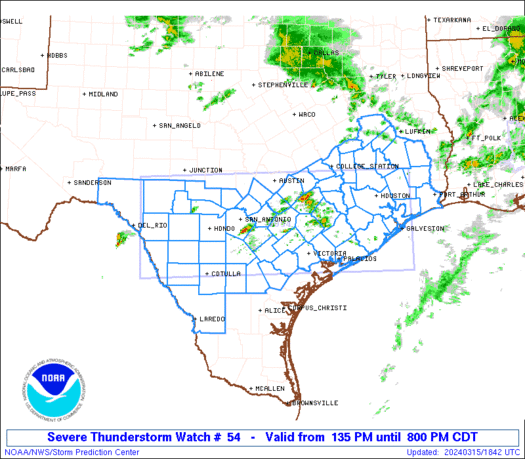
URGENT - IMMEDIATE BROADCAST REQUESTED
Severe Thunderstorm Watch Number 54
NWS Storm Prediction Center Norman OK
135 PM CDT Fri Mar 15 2024
The NWS Storm Prediction Center has issued a
* Severe Thunderstorm Watch for portions of
southern and southeastern Texas
Coastal Waters
* Effective this Friday afternoon and evening from 135 PM until
800 PM CDT.
* Primary threats include...
Widespread large hail likely with isolated very large hail
events to 3 inches in diameter possible
Scattered damaging wind gusts to 70 mph possible
SUMMARY...Thunderstorms are expected to expand in coverage across
southern and eventually into southeastern Texas over the next few
hours. Very large hail will be possible with these storms, along
with potential for locally damaging wind gusts and perhaps a
tornado. Storms may linger into the evening, particularly across
western portions of the watch across the Rio Grande Valley vicinity.
The severe thunderstorm watch area is approximately along and 70
statute miles either side of a line from 95 miles west of Hondo TX
to 15 miles northeast of Galveston TX. For a complete depiction of
the watch see the associated watch outline update (WOUS64 KWNS
WOU4).
PRECAUTIONARY/PREPAREDNESS ACTIONS...
REMEMBER...A Severe Thunderstorm Watch means conditions are
favorable for severe thunderstorms in and close to the watch area.
Persons in these areas should be on the lookout for threatening
weather conditions and listen for later statements and possible
warnings. Severe thunderstorms can and occasionally do produce
tornadoes.
&&
OTHER WATCH INFORMATION...CONTINUE...WW 53...
AVIATION...A few severe thunderstorms with hail surface and aloft to
3 inches. Extreme turbulence and surface wind gusts to 60 knots. A
few cumulonimbi with maximum tops to 500. Mean storm motion vector
24035.
...Goss
0 likes
The above post is NOT an official forecast and should not be used as such. It is just the opinion of the poster and may or may not be backed by sound meteorological data. It is NOT endorsed by any professional institution including Storm2k. For official information, please refer to NWS products.
-
txtwister78

- Category 5
- Posts: 1011
- Joined: Wed Jan 30, 2019 12:56 pm
- Location: San Antonio
Re: Texas Spring 2024
Edwards Limestone wrote:South Texas Storms wrote:Edwards Limestone wrote:Latest HRRR develops storms today mostly south and east of the Edwards Plateau.
Yeah unfortunately that outflow boundary is gonna shaft areas from SA northward from our first round of storms today. Thankfully we have more good chances arriving this weekend. Hopefully we can cash in some from that.
Weird watch outline imo considering that outflow boundary position...idk. Maybe just being on the safe side.
https://www.spc.noaa.gov/products/watch/ww0054_radar_init_resize.gif
Response to Edwards Limestone: Not necessarily. Storms beginning to develop along the border of Mexico and those appear to be headed toward Eagle Pass as well as another cluster near Camp Wood. I would say the northern area of the watch within the southern HC was probably more of an "err on the safe side" of things to your point but that's not unusual when these are issued IMO. Environment up there was definitely more stable today.
On the positive side of things...HRRR which has been handling today fairly well overall still onboard with some hefty rainfall amounts over the weekend across the San Antonio metro.
Last edited by txtwister78 on Fri Mar 15, 2024 4:08 pm, edited 1 time in total.
2 likes
-
cheezyWXguy

- Category 5
- Posts: 5532
- Joined: Mon Feb 13, 2006 12:29 am
- Location: Dallas, TX
Re: Texas Spring 2024
I’m sure it’ll be gone next run, but yeesh, that negatively tilted bowling ball trough at hour 216 on the 12z gfs would likely set up for a pretty notable severe weather episode for Texas
0 likes
-
Texas Snowman

- Storm2k Moderator

- Posts: 6011
- Joined: Fri Jan 25, 2008 11:29 am
- Location: Denison, Texas
Re: Texas Spring 2024
1 likes
The above post and any post by Texas Snowman is NOT an official forecast and should not be used as such. It is just the opinion of the poster and may or may not be backed by sound meteorological data. It is NOT endorsed by any professional institution including storm2k.org. For official information, please refer to NWS products.

Re: Texas Spring 2024
Normally, this type of weather would piss me off.
But the way I see it, let's get it all out of the way before the Solar Eclipse.
But the way I see it, let's get it all out of the way before the Solar Eclipse.
1 likes
-
Brent
- S2K Supporter
- Posts: 37099
- Age: 35
- Joined: Sun May 16, 2004 10:30 pm
- Location: Tulsa Oklahoma
- Contact:
Re: Texas Spring 2024
There's places in Wisconsin that haven't seen a flake of snow all month wow
Oh and I totally agree on getting the bad weather out of here before the eclipse hopefully
Oh and I totally agree on getting the bad weather out of here before the eclipse hopefully
0 likes
#neversummer
Re: Texas Spring 2024
Brent wrote:There's places in Wisconsin that haven't seen a flake of snow all month wow
Oh and I totally agree on getting the bad weather out of here before the eclipse hopefully
The bolded is likely to change next week.
There's even snowstorm potential.
0 likes
-
cheezyWXguy
- Category 5
- Posts: 5532
- Joined: Mon Feb 13, 2006 12:29 am
- Location: Dallas, TX
Re: Texas Spring 2024
Despite what I posted above about the system I noted probably “being gone next run” the gfs has been somewhat consistent in showing that system in some form around 3/25. I haven’t checked other models yet, but I wonder if that system is responsible for the signal depicted here.
0 likes
-
txtwister78
- Category 5
- Posts: 1011
- Joined: Wed Jan 30, 2019 12:56 pm
- Location: San Antonio
Re: Texas Spring 2024
Still optimistic that San Antonio metro gets our rain later tonight (despite southern areas getting over an inch thus far). One thing that models have underdone today in our favor down in this area is surface temps. With the sun out this afternoon, temps are already pushing close to 80 and that should help with destabilization to support and maintain thunderstorms that most models develop off to our west/southwest tonight pushing into SA metro around midnight.
3 likes
-
HockeyTx82
- S2K Supporter
- Posts: 1991
- Joined: Tue Oct 27, 2009 11:17 am
- Location: Ponder, TX
Re: Texas Spring 2024
cheezyWXguy wrote:
Despite what I posted above about the system I noted probably “being gone next run” the gfs has been somewhat consistent in showing that system in some form around 3/25. I haven’t checked other models yet, but I wonder if that system is responsible for the signal depicted here.
You know things are bad when the supercell parameter outlook looks like a giant supercell.
0 likes
Don't hold me accountable for anything I post on this forum. Leave the real forecasting up to the professionals.
Location: Ponder, TX (all observation posts are this location unless otherwise noted)
Location: Ponder, TX (all observation posts are this location unless otherwise noted)
-
Edwards Limestone
- S2K Supporter
- Posts: 338
- Age: 34
- Joined: Tue Dec 28, 2021 11:05 am
- Location: Smithson Valley, TX
Re: Texas Spring 2024
txtwister78 wrote:Still optimistic that San Antonio metro gets our rain later tonight (despite southern areas getting over an inch thus far). One thing that models have underdone today in our favor down in this area is surface temps. With the sun out this afternoon, temps are already pushing close to 80 and that should help with destabilization to support and maintain thunderstorms that most models develop off to our west/southwest tonight pushing into SA metro around midnight.
I’ll believe it when I see it. It’s been maddening watching everywhere around the southern hill country get rain but here. Hopefully tonight/tomorrow brings some good rainfall.
0 likes
The above post is NOT an official forecast and should not be used as such. It is just the opinion of the poster and may or may not be backed by sound meteorological data. It is NOT endorsed by any professional institution including Storm2k. For official information, please refer to NWS products.
Re: Texas Spring 2024
About 3/4th's of an inch today at DFW airport which brings the total over 4.28" or so for March.
1 likes
The above post and any post by Ntxw is NOT an official forecast and should not be used as such. It is just the opinion of the poster and may or may not be backed by sound meteorological data. It is NOT endorsed by any professional institution including Storm2k. For official information, please refer to NWS products.
Help support Storm2K!
Return to “USA & Caribbean Weather”
Who is online
Users browsing this forum: Brent and 178 guests