Florida Weather
Moderator: S2k Moderators
Forum rules

The posts in this forum are NOT official forecast and should not be used as such. They are just the opinion of the poster and may or may not be backed by sound meteorological data. They are NOT endorsed by any professional institution or STORM2K.
Re: Florida Weather
that 8-14 day outlook is unnerving. it shows 70% anoms down to central florida...the great lakes max out only one category higher at 80. That's probably one of the worst 8-14 days (for those that fear freezes) in a long time. No comfort there. not even close. more like alarm bells.
0 likes


Re: Florida Weather
I will not get concerned until this forecast comes into the shorter range.
Wonder how much climatology plays into the models predictions?
Wonder how much climatology plays into the models predictions?
0 likes
Re: Florida Weather
Good thing this is far out. we've got lots of time for more sane solutions to appear.
1 likes
-
gatorcane

- S2K Supporter

- Posts: 23499
- Age: 46
- Joined: Sun Mar 13, 2005 3:54 pm
- Location: Boca Raton, FL
Re: Florida Weather
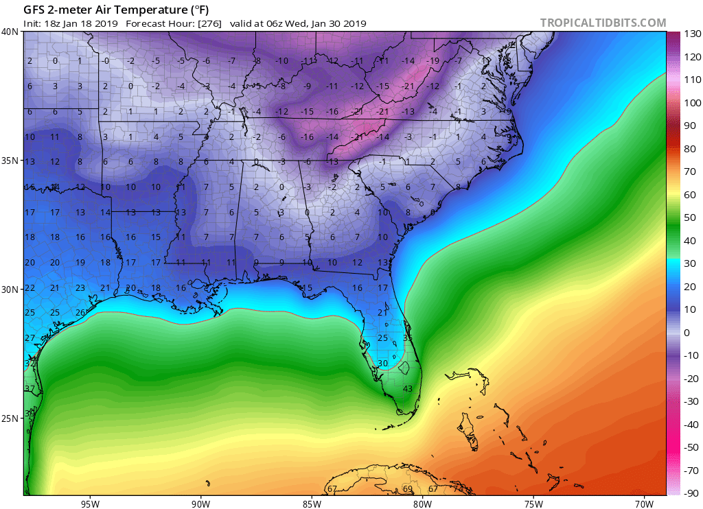
SFLcane wrote:18z Gfs with freezing temps to near broward...
A closer look...interesting how there is some 25-30 degree temp difference beteeen South and North Florida. Obviously details don’t mean much this far out but might the core of the cold just miss South Florida?
0 likes
-
SFLcane

- S2K Supporter
- Posts: 9606
- Age: 46
- Joined: Sat Jun 05, 2010 1:44 pm
- Location: Lake Worth Florida
Re: Florida Weather
gatorcane wrote:SFLcane wrote:18z Gfs with freezing temps to near broward...
A closer look...interesting how there is some 25-30 degree temp difference beteeen South and North Florida. Obviously details don’t mean much this far out but might the core of the cold just miss South Florida?
https://i.postimg.cc/XqXZC0tf/gfs-T2m-seus-44.png
Nope at fantasy 300hr freezing is south of the lake.
0 likes

Re: Florida Weather
Very rare to see temps below 45 here along SE Florida and I don’t see that happening until it’s within 3 days.
0 likes
-
TheStormExpert

- Category 5

- Posts: 8487
- Age: 30
- Joined: Wed Feb 16, 2011 5:38 pm
- Location: Palm Beach Gardens, FL
Re: Florida Weather
boca wrote:Very rare to see temps below 45 here along SE Florida and I don’t see that happening until it’s within 3 days.
And just that fast the 00z GFS completely drops it.
2 likes
The following post is NOT an official forecast and should not be used as such. It is just the opinion of the poster and may or may not be backed by sound meteorological data. It is NOT endorsed by storm2k.org.
Re: Florida Weather
TheStormExpert wrote:boca wrote:Very rare to see temps below 45 here along SE Florida and I don’t see that happening until it’s within 3 days.
And just that fast the 00z GFS completely drops it.
I’m going to have 4 days of winter I’m going to New York on the 24th hopefully seeing snow or flurries. Than coming back to 50s at night and 70s during the day. The NAO is not going negative so these model predictions are just a grain of salt.
1 likes

Re: Florida Weather
Let me remind everyone that the GFS past its 5 day range and the Euro past its 6-7 day range is mainly for entertainment purposes only when they show an extreme solution like yesterday's 12z Euro and GFS's 18z run.
Don't forget that they were both showing 20s all the way down to Lake O for Monday morning on its 5-10 day range.
Not saying that it could not happen but use it with a caution on that range because chances of not coming to fruition are higher than in their shorter term
Don't forget that they were both showing 20s all the way down to Lake O for Monday morning on its 5-10 day range.
Not saying that it could not happen but use it with a caution on that range because chances of not coming to fruition are higher than in their shorter term
Last edited by NDG on Sat Jan 19, 2019 8:37 am, edited 1 time in total.
1 likes
-
northjaxpro

- S2K Supporter
- Posts: 8900
- Joined: Mon Sep 27, 2010 11:21 am
- Location: Jacksonville, FL
Re: Florida Weather
I do not want to lose sight on potential heavy weather up here late tonight with the approach of the strong cold front, which will be coming through Northeast Florida between 11 p.m. - 3 a.m. tomorrow morning.
Models showing potential of possible severe thunderstorms up across Georgia and a line of storms developing along and just ahead of the frontal boundary. It is definitely something I will be closely monitoring late tonight.
Also, still on track for the colder, inland locales across North and Northeast Florida seeing a light freeze on Monday morning with temps expected to drop in the lower 30s in most areas.
There will be plenty of time to talk about the extended range arctic air outbreak potential. a bit later...
0 likes
NEVER, EVER SAY NEVER in the tropics and weather in general, and most importantly, with life itself!!
________________________________________________________________________________________
Fay 2008 Beryl 2012 Debby 2012 Colin 2016 Hermine 2016 Julia 2016 Matthew 2016 Irma 2017 Dorian 2019
________________________________________________________________________________________
Fay 2008 Beryl 2012 Debby 2012 Colin 2016 Hermine 2016 Julia 2016 Matthew 2016 Irma 2017 Dorian 2019
Re: Florida Weather
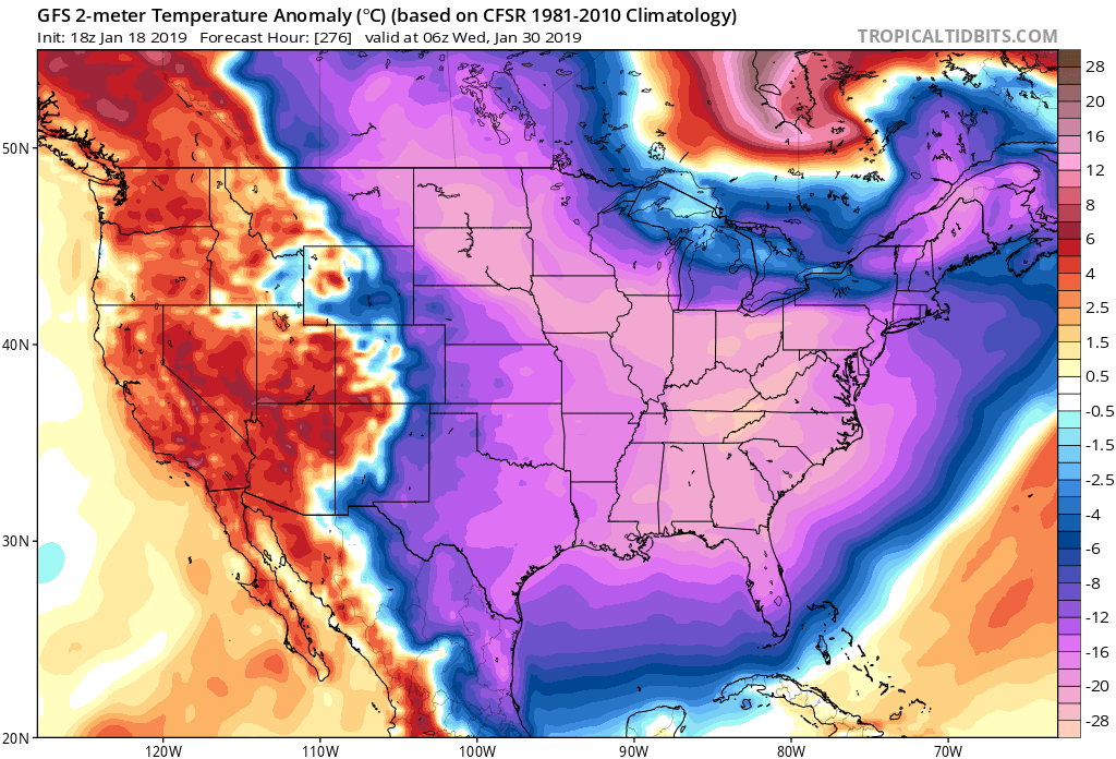
No wonder the 18z GFS was so extremely cold for the entire eastern US, it shows the PV currently over the northern Hudson Bay dropping down to the Great Lakes!!
That's very rare to see.

That's very rare to see.
0 likes
-
HURRICANELONNY
- Category 5
- Posts: 1381
- Joined: Wed May 07, 2003 6:48 am
- Location: HOLLYWOOD.FL
Re: Florida Weather
You ain't lying about looking past 5 days on models NDG. The kickoff forecasted around 0 on kickoff for KC/NE game Sunday. Now it's going to be in the 20's. 
0 likes
hurricanelonny
-
northjaxpro
- S2K Supporter
- Posts: 8900
- Joined: Mon Sep 27, 2010 11:21 am
- Location: Jacksonville, FL
Re: Florida Weather
NDG wrote:No wonder the 18z GFS was so extremely cold for the entire eastern US, it shows the PV currently over the northern Hudson Bay dropping down to the Great Lakes!!
That's very rare to see.
https://i.imgur.com/xkbpW0v.png
It is NDG. It is extremely rare. Actually the 18Z GFS run from yesterday was actually playing catch-up to the 12Z EURO which initially showed the PV displaced much farther southward. We discussed it yesterdsy.
We still have a quite a bit of time left about this, and we just need to wait for run to run consistency from the models about the extended range. I hope by at least Tuesday of next week, we should have a bit clearer picture from our reliable models about this arctic potential.
More later......
1 likes
NEVER, EVER SAY NEVER in the tropics and weather in general, and most importantly, with life itself!!
________________________________________________________________________________________
Fay 2008 Beryl 2012 Debby 2012 Colin 2016 Hermine 2016 Julia 2016 Matthew 2016 Irma 2017 Dorian 2019
________________________________________________________________________________________
Fay 2008 Beryl 2012 Debby 2012 Colin 2016 Hermine 2016 Julia 2016 Matthew 2016 Irma 2017 Dorian 2019
Re: Florida Weather
northjaxpro wrote:NDG wrote:No wonder the 18z GFS was so extremely cold for the entire eastern US, it shows the PV currently over the northern Hudson Bay dropping down to the Great Lakes!!
That's very rare to see.
https://i.imgur.com/xkbpW0v.png
It is NDG. It is extremely rare. Actually the 18Z GFS run from yesterday was actually playing catch-up to the 12Z EURO which initially showed the PV displaced much farther southward. We discussed it yesterdsy.
We still have a auite a bit of time to go about this, and we just need to wait out looking for consistency from the models about the extended range. I hope by at least Tuesday of next week, we should have a bit clearer picture from our reliable models about this arctic potential.
More later......
I tell you what if the NAO & AO go way negative over the next couple of weeks the displaced piece of PV over Hudson Bay moving down into the US could really happen, very important to watch over the next few days.
0 likes
-
northjaxpro
- S2K Supporter
- Posts: 8900
- Joined: Mon Sep 27, 2010 11:21 am
- Location: Jacksonville, FL
Re: Florida Weather
NDG wrote:northjaxpro wrote:NDG wrote:No wonder the 18z GFS was so extremely cold for the entire eastern US, it shows the PV currently over the northern Hudson Bay dropping down to the Great Lakes!!
That's very rare to see.
https://i.imgur.com/xkbpW0v.png
It is NDG. It is extremely rare. Actually the 18Z GFS run from yesterday was actually playing catch-up to the 12Z EURO which initially showed the PV displaced much farther southward. We discussed it yesterdsy.
We still have a auite a bit of time to go about this, and we just need to wait out looking for consistency from the models about the extended range. I hope by at least Tuesday of next week, we should have a bit clearer picture from our reliable models about this arctic potential.
More later......
I tell you what if the NAO & AO go way negative over the next couple of weeks the displaced piece of PV over Hudson Bay moving down into the US could really happen, very important to watch over the next few days.
Yes sir indeed. It always is about the Polar Vortex in these very anomalous, massive large scaled patterns like this evolving one now.This is what I am really focusing on as well. The PV placement, if the EURO and GFS solutions hold up over the next few days, well, the potential of serious cold in this region reallycould get insane folks.
I don't want to get too far ahead right now. Again, looking for continued run to run consistency next few days...
1 likes
NEVER, EVER SAY NEVER in the tropics and weather in general, and most importantly, with life itself!!
________________________________________________________________________________________
Fay 2008 Beryl 2012 Debby 2012 Colin 2016 Hermine 2016 Julia 2016 Matthew 2016 Irma 2017 Dorian 2019
________________________________________________________________________________________
Fay 2008 Beryl 2012 Debby 2012 Colin 2016 Hermine 2016 Julia 2016 Matthew 2016 Irma 2017 Dorian 2019
-
TheStormExpert
- Category 5
- Posts: 8487
- Age: 30
- Joined: Wed Feb 16, 2011 5:38 pm
- Location: Palm Beach Gardens, FL
Re: Florida Weather
NDG wrote:No wonder the 18z GFS was so extremely cold for the entire eastern US, it shows the PV currently over the northern Hudson Bay dropping down to the Great Lakes!!
That's very rare to see.
https://i.imgur.com/xkbpW0v.png
It’s also why during hurricane season it’s called the “Happy Hour” GFS run.
0 likes
The following post is NOT an official forecast and should not be used as such. It is just the opinion of the poster and may or may not be backed by sound meteorological data. It is NOT endorsed by storm2k.org.
Re: Florida Weather
northjaxpro wrote:NDG wrote:northjaxpro wrote:
It is NDG. It is extremely rare. Actually the 18Z GFS run from yesterday was actually playing catch-up to the 12Z EURO which initially showed the PV displaced much farther southward. We discussed it yesterdsy.
We still have a auite a bit of time to go about this, and we just need to wait out looking for consistency from the models about the extended range. I hope by at least Tuesday of next week, we should have a bit clearer picture from our reliable models about this arctic potential.
More later......
I tell you what if the NAO & AO go way negative over the next couple of weeks the displaced piece of PV over Hudson Bay moving down into the US could really happen, very important to watch over the next few days.
Yes sir indeed. It always is about the Polar Vortex in these very anomalous, massive large scaled patterns like this evolving one now.This is what I am really focusing on as well. The PV placement, if the EURO and GFS solutions hold up over the next few days, well, the potential of serious cold in this region reallycould get insane folks.
I don't want to get too far ahead right now. Again, looking for continued run to run consistency next few days...
I was going back to when the models were showing 20s come down to Lake O for this Monday and Tuesday, the reason I think they were showing this was because they were forecasting the PNA to go positive but instead it has stayed near neutral this weekend, now the models again show the PNA to go positive, we shall see.
0 likes
-
northjaxpro
- S2K Supporter
- Posts: 8900
- Joined: Mon Sep 27, 2010 11:21 am
- Location: Jacksonville, FL
Re: Florida Weather
1 likes
NEVER, EVER SAY NEVER in the tropics and weather in general, and most importantly, with life itself!!
________________________________________________________________________________________
Fay 2008 Beryl 2012 Debby 2012 Colin 2016 Hermine 2016 Julia 2016 Matthew 2016 Irma 2017 Dorian 2019
________________________________________________________________________________________
Fay 2008 Beryl 2012 Debby 2012 Colin 2016 Hermine 2016 Julia 2016 Matthew 2016 Irma 2017 Dorian 2019
Return to “USA & Caribbean Weather”
Who is online
Users browsing this forum: No registered users and 58 guests