Florida Weather
Moderator: S2k Moderators
Forum rules

The posts in this forum are NOT official forecast and should not be used as such. They are just the opinion of the poster and may or may not be backed by sound meteorological data. They are NOT endorsed by any professional institution or STORM2K.
-
gatorcane

- S2K Supporter

- Posts: 23499
- Age: 46
- Joined: Sun Mar 13, 2005 3:54 pm
- Location: Boca Raton, FL
Re: Florida Weather
The GFS really ramps up the low down to 997MB. Then after that the entire week of Christmas shows below normal temps for Florida almost to New Year’s.
0 likes
-
gatorcane
- S2K Supporter
- Posts: 23499
- Age: 46
- Joined: Sun Mar 13, 2005 3:54 pm
- Location: Boca Raton, FL
Re: Florida Weather
The 06Z GFS is bringing a low of 42F to Miami a week from now as the low to mid-level low off the SE US coast sends cold continental air down the state. As TheStormExpert pointed out, similar setup to a month ago but it would be colder this time. 
0 likes
-
northjaxpro

- S2K Supporter
- Posts: 8900
- Joined: Mon Sep 27, 2010 11:21 am
- Location: Jacksonville, FL
Re: Florida Weather
gatorcane wrote:The 06Z GFS is bringing a low of 42F to Miami a week from now as the low to mid-level low off the SE US coast sends cold continental air down the state. As TheStormExpert pointed out, similar setup to a month ago but it would be colder this time.
This time around this upcoming next weekend, we look to finally have a meteorological winter - NAO occuring with this system this weekend.Yes indeed much colder temps potentially by next weekend statewide. Freezes look very possible interior North Florida on Thursday morning and again during next weekend.
I am following closely the potential storm system closely in the Deep South Thread. Big differences with the GFS and EURO with the development thus far. 00Z GFS developed a major potentiial coastal/winter storm off the SC coast and bombs it to 980 mb by 12Z next Sunday morning. Meanwhile.the 00Z EURO keeps the shortwave rather lame, compared to the very aggressive GFS, and dies mot sharply amplify the trough at all this rum. Something to monitor closely all week. One thing I am also taking note of is that although we are finally seeing - NAO index, a saving grace potentially is that true bore Siberian Air dump has yet to be tapped and headed south. Plus, we still have lacking a decent snowpack in areas across the CONUS, especially across the Midwest and Ohio and TN Valley regions. So, it will definitely get cold during the next week to 10 days or so, but not the harsh brutal cold , like we saw back in 2009-10. Well, at least not yet.
0 likes
NEVER, EVER SAY NEVER in the tropics and weather in general, and most importantly, with life itself!!
________________________________________________________________________________________
Fay 2008 Beryl 2012 Debby 2012 Colin 2016 Hermine 2016 Julia 2016 Matthew 2016 Irma 2017 Dorian 2019
________________________________________________________________________________________
Fay 2008 Beryl 2012 Debby 2012 Colin 2016 Hermine 2016 Julia 2016 Matthew 2016 Irma 2017 Dorian 2019

Re: Florida Weather
I wouldn't hold my breath for anything to come to fruition past the models' 5-7 day range. At one point the Euro had in its 7-10 day range lows dropping in the low to mid 40s in SE FL next Thursday morning.
NAO is going slightly negative but the PNA is also going back negative for more of a fast zonal flow across the US over all.
Back in the winter of '09/'10 the PNA was mostly positive for the whole time which helped the -NAO & -AO deliver record cold temps down to FL in Jan & Feb of 2010.
NAO is going slightly negative but the PNA is also going back negative for more of a fast zonal flow across the US over all.
Back in the winter of '09/'10 the PNA was mostly positive for the whole time which helped the -NAO & -AO deliver record cold temps down to FL in Jan & Feb of 2010.
0 likes
-
TheStormExpert

- Category 5

- Posts: 8487
- Age: 30
- Joined: Wed Feb 16, 2011 5:38 pm
- Location: Palm Beach Gardens, FL
Re: Florida Weather
The GFS has already backed off that chilly idea on its 12z run as it ejects a potent (tropical?) low and the 500mb low East or Southeast rather quickly. Meanwhile the Euro is back on board and does the same just minus the weird strong low.
0 likes
The following post is NOT an official forecast and should not be used as such. It is just the opinion of the poster and may or may not be backed by sound meteorological data. It is NOT endorsed by storm2k.org.
Re: Florida Weather
If the 12z GFS was to come to fruition this would be one heck of a hybrid storm, but both the GFS and Euro have been all over with this potential system.

0 likes
-
northjaxpro
- S2K Supporter
- Posts: 8900
- Joined: Mon Sep 27, 2010 11:21 am
- Location: Jacksonville, FL
Re: Florida Weather
PNA is briefly positive up through Friday. The PNA will become solid negative right up through to New Year's Day beginning Dec. 20
PNA being briefly positive gives us a decent chance of seeing another inland freeze on Thursday morning. It will be very close, a similar situation we had back on December 3, when the first measured freeze of the season occured here at my home station. We could see another record high temperature record on tomorrow before this next front moves through on Wednesday as strong warm air advection on southwesterly flow will takeplace. It will also bring anotherround of rain and storms for Tuesday up until the front passes through the region.
NDG earlier mentioned that the -PNA and its influence on the overall pattern. He is spot on about that. The negative PNA pattern indeed keeps the fast, progressive westerlies across the CONUS and it is not allowing for the arctic air to come southward. Plain and simple. So, even though we have a -NAO currently, we don't have the cold in place to really feel its true impact. We do not have the Greenland Blocking pattern in place right now, which is usually prominent or present when a true - NAO is in place. A Positive PNA brings higher pressures to Western Canada and the Intermountain West, which in turn brings down a northwesterly continentinal flow which can bring Cold into the Eastern and Southeastern U.S. In some of these instances, it is of arctic air dislodgment.
I always mention to really truly feel cold arctic air down to Florida and the Gulf Coast region, the perfect teleconnections alignment trifecta would be +PNA, -NAO and -AO. Right now we only have 1 out of the 3 going. We have not truly had this alignment since the 2009-10 meteorological winter season.
We will have to see if the pattern will flip for January.
0 likes
NEVER, EVER SAY NEVER in the tropics and weather in general, and most importantly, with life itself!!
________________________________________________________________________________________
Fay 2008 Beryl 2012 Debby 2012 Colin 2016 Hermine 2016 Julia 2016 Matthew 2016 Irma 2017 Dorian 2019
________________________________________________________________________________________
Fay 2008 Beryl 2012 Debby 2012 Colin 2016 Hermine 2016 Julia 2016 Matthew 2016 Irma 2017 Dorian 2019
-
gatorcane
- S2K Supporter
- Posts: 23499
- Age: 46
- Joined: Sun Mar 13, 2005 3:54 pm
- Location: Boca Raton, FL
Re: Florida Weather
Stormy is an understatement for Florida this weekend if the 12Z GFS is to be believed. Could the storm as shown on the GFS get named?
0 likes
-
northjaxpro
- S2K Supporter
- Posts: 8900
- Joined: Mon Sep 27, 2010 11:21 am
- Location: Jacksonville, FL
Re: Florida Weather
gatorcane wrote:Stormy is an understatement for Florida this weekend if the 12Z GFS is to be believed. Could the storm as shown on the GFS get named?
I have been monitorng this situation, and GFS has been all over the place with this system the past 3 days, so much to the point in that I am about to stop looking at the model completely
I will go with that there will be some type of wind and rsin event concentrated over the Florida peninsula or Southeast U.S. Coast region during this upcoming weekend I suppose.
0 likes
NEVER, EVER SAY NEVER in the tropics and weather in general, and most importantly, with life itself!!
________________________________________________________________________________________
Fay 2008 Beryl 2012 Debby 2012 Colin 2016 Hermine 2016 Julia 2016 Matthew 2016 Irma 2017 Dorian 2019
________________________________________________________________________________________
Fay 2008 Beryl 2012 Debby 2012 Colin 2016 Hermine 2016 Julia 2016 Matthew 2016 Irma 2017 Dorian 2019
-
gatorcane
- S2K Supporter
- Posts: 23499
- Age: 46
- Joined: Sun Mar 13, 2005 3:54 pm
- Location: Boca Raton, FL
Re: Florida Weather
northjaxpro wrote:gatorcane wrote:Stormy is an understatement for Florida this weekend if the 12Z GFS is to be believed. Could the storm as shown on the GFS get named?
I have been monitorng this situation, and GFS has beenall over the place with this system the past 3 days, so much to the point in thst I am about to stop looking at the model completely
I will go with that there will be some type of wind and rsin event concentrated over the Florida peninsula or Southeast U.S. Coast region during this upcoming weekend I suppose.
Looks like CMC might be jumping on board or at least trending that way.
0 likes
-
gatorcane
- S2K Supporter
- Posts: 23499
- Age: 46
- Joined: Sun Mar 13, 2005 3:54 pm
- Location: Boca Raton, FL
Re: Florida Weather
Just like that the Euro has swung big time to the GFS with a 996MB low over the Northern Gulf coast. Getting interesting.
0 likes
-
northjaxpro
- S2K Supporter
- Posts: 8900
- Joined: Mon Sep 27, 2010 11:21 am
- Location: Jacksonville, FL
Re: Florida Weather
Yeah, the EURO had the system generally east and of Florida, until the set of runs since last night. Now, it is showing this storm to come directly over North Florida on next Monday morning.

So, for now, EURO has jumped on board with GFS, CMC and ICON showing this very potent shortwave/storm system impacting the Florida peninsula later this weekend into early next week. This is a very impressive looking system being forecast into this upcoming weekend into next Monday.
Definitely a system to track this week into early next week!!
0 likes
NEVER, EVER SAY NEVER in the tropics and weather in general, and most importantly, with life itself!!
________________________________________________________________________________________
Fay 2008 Beryl 2012 Debby 2012 Colin 2016 Hermine 2016 Julia 2016 Matthew 2016 Irma 2017 Dorian 2019
________________________________________________________________________________________
Fay 2008 Beryl 2012 Debby 2012 Colin 2016 Hermine 2016 Julia 2016 Matthew 2016 Irma 2017 Dorian 2019
-
FlaWeatherDude

- Tropical Storm

- Posts: 110
- Age: 39
- Joined: Wed Oct 10, 2018 2:57 pm
- Location: Orlando, FL.
Re: Florida Weather
EPS is still faster though. 12z Euro is drunk!
0 likes
"Windy has wings to fly above the clouds".
-
gatorcane
- S2K Supporter
- Posts: 23499
- Age: 46
- Joined: Sun Mar 13, 2005 3:54 pm
- Location: Boca Raton, FL
Re: Florida Weather
Completely different solution on the 18Z GFS 
The low is way off east in the Atlantic this run:
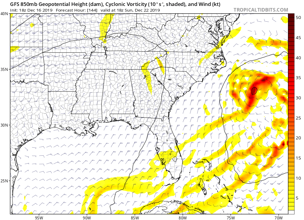
The low is way off east in the Atlantic this run:
1 likes
-
northjaxpro
- S2K Supporter
- Posts: 8900
- Joined: Mon Sep 27, 2010 11:21 am
- Location: Jacksonville, FL
Re: Florida Weather
I do not know what to make of the GFS pertaining to this system right now.
0 likes
NEVER, EVER SAY NEVER in the tropics and weather in general, and most importantly, with life itself!!
________________________________________________________________________________________
Fay 2008 Beryl 2012 Debby 2012 Colin 2016 Hermine 2016 Julia 2016 Matthew 2016 Irma 2017 Dorian 2019
________________________________________________________________________________________
Fay 2008 Beryl 2012 Debby 2012 Colin 2016 Hermine 2016 Julia 2016 Matthew 2016 Irma 2017 Dorian 2019
-
FlaWeatherDude
- Tropical Storm
- Posts: 110
- Age: 39
- Joined: Wed Oct 10, 2018 2:57 pm
- Location: Orlando, FL.
Re: Florida Weather
I think this system will trend towards a potentially Carolina beast!
0 likes
"Windy has wings to fly above the clouds".
-
northjaxpro
- S2K Supporter
- Posts: 8900
- Joined: Mon Sep 27, 2010 11:21 am
- Location: Jacksonville, FL
Re: Florida Weather
This morning's 06Z GFS run just rolling in showing the potent Low Pressure area slowly crossing Central Florida from the GOM and has it at 998 mb near Cape Canaveral at 06Z early Monday 12/23.
It is safe to presume now there is consensus among the reliable models that we will be dealing with a very potent Low Pressure system late this weekend into early next week. Looking at the dynamics of this system, it is setting up to be potentially very impressive, especially with rain, strong winds and possibly severe weather across much of the peninsula.
We are still about 5 days away from this event and more changes are coming as the system is taking shape, but there will be much more to process with the models as to the exact track and intensity of this system as this week progresses.
Now, as to regards to the next cold front approaching our region later today, there will be a risk of some strong to possiibe severe thunderstorms across North Florida as strong southwest flow ahead of the front will bring about ample heating and instability and CAPE looks sufficient for the possibility of severe storm cells, mainly strong straight line wind. Isolated tornadoes always are a threat. We had a tornado touch down just south of here in Flagler County just last week.
We also could see another day of record max temps here as well as temps are forecast to reach into the lower 80s.
Cold front passes through the region late tonight and we chill back down. This morning's 06Z GFS has most of interior North Florida in the low to mid 30s on early Thursday morning. Just like back on December 3, it will be another close call with a freeze here at my home, which the first freeze of the season did occur that day. A light freeze in the colder, interior locales is very possible once again. Wind is forecast to become light emough to allow the temps to fall during the pre-dawn hours to the freeze mark in these areas. We have a very brief positive PNA index for this week, which I think will help to get another freeze across the interior North Florida region on Thursday morning.
Last edited by northjaxpro on Tue Dec 17, 2019 9:13 am, edited 4 times in total.
1 likes
NEVER, EVER SAY NEVER in the tropics and weather in general, and most importantly, with life itself!!
________________________________________________________________________________________
Fay 2008 Beryl 2012 Debby 2012 Colin 2016 Hermine 2016 Julia 2016 Matthew 2016 Irma 2017 Dorian 2019
________________________________________________________________________________________
Fay 2008 Beryl 2012 Debby 2012 Colin 2016 Hermine 2016 Julia 2016 Matthew 2016 Irma 2017 Dorian 2019
Re: Florida Weather
It has a lot of support from its EPS and to some degree from the GFS ensembles.

Last edited by NDG on Tue Dec 17, 2019 7:00 am, edited 1 time in total.
0 likes
Re: Florida Weather
FlaWeatherDude wrote:I think this system will trend towards a potentially Carolina beast!
High pressure in the mid levels forecasted to stay in place to the north through early next week will not let this happen.

1 likes
-
SFLcane

- S2K Supporter
- Posts: 9606
- Age: 46
- Joined: Sat Jun 05, 2010 1:44 pm
- Location: Lake Worth Florida
Re: Florida Weather
This weekend could be a washout state wide across the FL peninsula. Last min Xmas shopping 
0 likes
Return to “USA & Caribbean Weather”
Who is online
Users browsing this forum: No registered users and 59 guests