Florida Weather
Moderator: S2k Moderators
Forum rules

The posts in this forum are NOT official forecast and should not be used as such. They are just the opinion of the poster and may or may not be backed by sound meteorological data. They are NOT endorsed by any professional institution or STORM2K.
-
Hypercane_Kyle

- Category 5

- Posts: 2900
- Joined: Sat Mar 07, 2015 7:58 pm
- Location: Cape Canaveral, FL
Re: Florida Weather
Thus far, this has been one of the greyest Florida falls I've ever seen.
0 likes
My posts are my own personal opinion, defer to the National Hurricane Center (NHC) and other NOAA products for decision making during hurricane season.
-
NotSparta

- Professional-Met

- Posts: 1655
- Age: 22
- Joined: Fri Aug 18, 2017 8:24 am
- Location: Naples, FL
- Contact:
Re: Florida Weather
We could use the rain from that storm, the cold front that passed through Naples yesterday snapped a 3-4 week long rainless streak
0 likes
This post was probably an opinion of mine, and in no way is official. Please refer to http://www.hurricanes.gov for official tropical analysis and advisories.
My website, with lots of tropical wx graphics, including satellite and recon: http://cyclonicwx.com
My website, with lots of tropical wx graphics, including satellite and recon: http://cyclonicwx.com
-
Blown Away

- S2K Supporter

- Posts: 9867
- Joined: Wed May 26, 2004 6:17 am
Re: Florida Weather
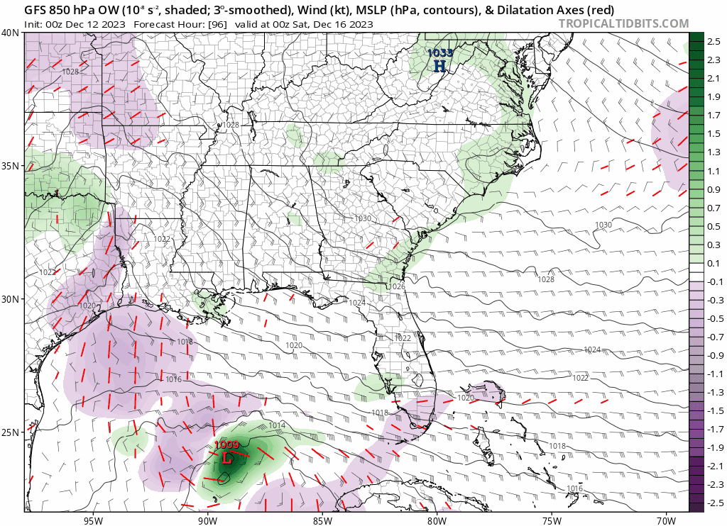
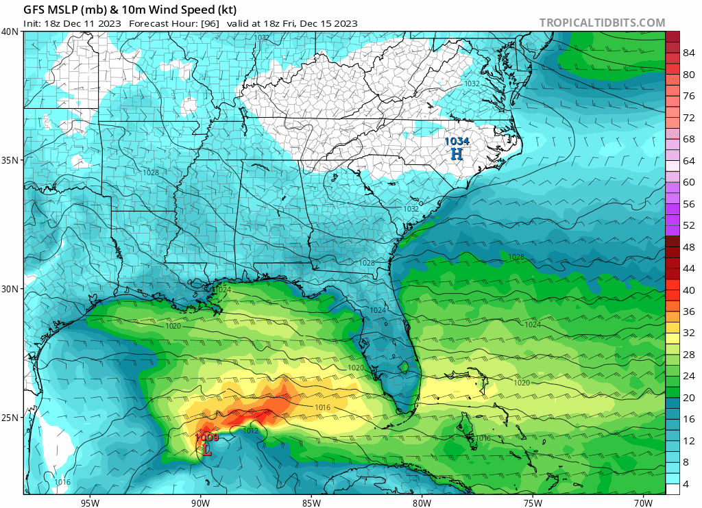
00z GFS… Nasty weather coming to FL
1 likes
Hurricane Eye Experience: David 79, Irene 99, Frances 04, Jeanne 04, Wilma 05... EYE COMING MY WAY IN 2024…
Hurricane Brush Experience: Andrew 92, Erin 95, Floyd 99, Matthew 16, Irma 17, Ian 22, Nicole 22…
Hurricane Brush Experience: Andrew 92, Erin 95, Floyd 99, Matthew 16, Irma 17, Ian 22, Nicole 22…
-
jlauderdal
- S2K Supporter
- Posts: 6776
- Joined: Wed May 19, 2004 5:46 am
- Location: NE Fort Lauderdale
- Contact:
Re: Florida Weather
gatorcane wrote:GFS 10mb winds:
https://i.postimg.cc/1X9NCHkC/gfs-mslp-wind-seus-fh96-168.gif
The last event overachieved in the wind department, precip was modeled very well.
0 likes
-
cycloneye

- Admin

- Posts: 139296
- Age: 67
- Joined: Thu Oct 10, 2002 10:54 am
- Location: San Juan, Puerto Rico
Re: Florida Weather
3 likes
Visit the Caribbean-Central America Weather Thread where you can find at first post web cams,radars
and observations from Caribbean basin members Click Here
and observations from Caribbean basin members Click Here
-
cycloneye
- Admin
- Posts: 139296
- Age: 67
- Joined: Thu Oct 10, 2002 10:54 am
- Location: San Juan, Puerto Rico
Re: Florida Weather
2 likes
Visit the Caribbean-Central America Weather Thread where you can find at first post web cams,radars
and observations from Caribbean basin members Click Here
and observations from Caribbean basin members Click Here
-
gatorcane

- S2K Supporter
- Posts: 23499
- Age: 46
- Joined: Sun Mar 13, 2005 3:54 pm
- Location: Boca Raton, FL
Re: Florida Weather
NWS Miami forecasting wind gusts to 60mph along the coast of SE Florida Thu night 
2 likes
Re: Florida Weather
SE florida is going to get creamed. This is yet another excellent heavy rain set up down that way. I expect someone gets a double digit total. If we get a good low with a warm front...some severe potential may evolve ..maybe some spinners somewhere on the peninsula
2 likes
-
Blown Away
- S2K Supporter
- Posts: 9867
- Joined: Wed May 26, 2004 6:17 am
Re: Florida Weather

This is going to be a good one!
0 likes
Hurricane Eye Experience: David 79, Irene 99, Frances 04, Jeanne 04, Wilma 05... EYE COMING MY WAY IN 2024…
Hurricane Brush Experience: Andrew 92, Erin 95, Floyd 99, Matthew 16, Irma 17, Ian 22, Nicole 22…
Hurricane Brush Experience: Andrew 92, Erin 95, Floyd 99, Matthew 16, Irma 17, Ian 22, Nicole 22…
-
jlauderdal
- S2K Supporter
- Posts: 6776
- Joined: Wed May 19, 2004 5:46 am
- Location: NE Fort Lauderdale
- Contact:
Re: Florida Weather
Blown Away wrote:[url]https://i.postimg.cc/WbyqTm2X/ecmwf-z850-vort-seus-fh72-126-1.gif [/url]
This is going to be a good one!
.22 so far at my place, double digits needed to compete with the last event
0 likes
-
HurricaneBelle

- S2K Supporter
- Posts: 975
- Joined: Sun Aug 27, 2006 6:12 pm
- Location: Clearwater, FL
Re: Florida Weather
12Z runs are in and the GFS and Euro continue to maintain their north-south disparity, but both are displaced farther north than their runs earlier in the week. GFS takes the low into the Panhandle through Tallahassee and Euro now brings the low right in over Tampa Bay. Seems that much of Florida may experience near-tropical storm or tropical storm-level conditions, especially Saturday into Sunday with a gusty NE fetch setting up in the days preceding landfall.
0 likes
Re: Florida Weather
This is going to be quite the system. With the more northerly track the entire peninsula will cash in on wind, rain and severe risk. Very curious to see how severe risk evolves and how high the marine winds get...will any storm warnings be needed for nearshore/offshore waters? Things to watch for..
0 likes

Re: Florida Weather
So far this weather doesn’t warrant a flood watch because it rained yesterday morning and has been drizzling on and off since. The wind is impressive outside of hurricane season gusts to 45 along the east coast.
1 likes
-
HurricaneBelle
- S2K Supporter
- Posts: 975
- Joined: Sun Aug 27, 2006 6:12 pm
- Location: Clearwater, FL
Re: Florida Weather
Still no agreement from the models at 12Z Thursday - GFS insists on the low tracking into the Panhandle, putting all of the peninsula in the warm sector while Euro brings the low into the Tampa Bay area again, leaving only SFL and south-central Florida in the warm sector.
0 likes
Re: Florida Weather
Coastal flood watches from the bay area up to the big bend are well placed. The big bathtub is gonna slosh
0 likes

Re: Florida Weather
I don't care how big the cruise ship, this certainly would NOT be the weekend that I'd want to leave from practically any Florida port (as my sister/brother in law are down in Miami) 
There's just not enough pressure point wrist bands and Dramamine to make those open water conditions tolerable.
There's just not enough pressure point wrist bands and Dramamine to make those open water conditions tolerable.
1 likes
Personal Forecast Disclaimer:
The posts in this forum are NOT official forecast and should not be used as such. They are just the opinion of the poster and may or may not be backed by sound meteorological data. They are NOT endorsed by any professional institution or storm2k.org. For official information, please refer to the NHC and NWS products.
The posts in this forum are NOT official forecast and should not be used as such. They are just the opinion of the poster and may or may not be backed by sound meteorological data. They are NOT endorsed by any professional institution or storm2k.org. For official information, please refer to the NHC and NWS products.
-
HurricaneBelle
- S2K Supporter
- Posts: 975
- Joined: Sun Aug 27, 2006 6:12 pm
- Location: Clearwater, FL
Re: Florida Weather
Models finally starting to converge on the low track with the GFS now south of previous positions coming in around Crystal River while the Euro has moved north a tad to Pasco/Hernando County, so the Nature Coast looks like the spot meaning the Tampa Bay area will be in the warm, wild sector.
0 likes
Re: Florida Weather
The more northerly track of the low relative to earlier expectations reduces the risk of extreme rain over southeast FL but increases the risk of svr wx over the entire peninsula. A decent tornado risk may develop somewhere over the peninsula. Between heavy rain, svr potential, strong gradient winds and associated marine hazards/coastal flooding...this will be quite a weather event. Pure Nino delivering the goods during what is normally a meteorological boring time of year. We will probably get more of these events this winter.
0 likes

-
jlauderdal
- S2K Supporter
- Posts: 6776
- Joined: Wed May 19, 2004 5:46 am
- Location: NE Fort Lauderdale
- Contact:
Re: Florida Weather
psyclone wrote:The more northerly track of the low relative to earlier expectations reduces the risk of extreme rain over southeast FL but increases the risk of svr wx over the entire peninsula. A decent tornado risk may develop somewhere over the peninsula. Between heavy rain, svr potential, strong gradient winds and associated marine hazards/coastal flooding...this will be quite a weather event. Pure Nino delivering the goods during what is normally a meteorological boring time of year. We will probably get more of these events this winter.
The gfs and euro still offering up different solutions, SPC brought a higher risk south which was interesting to see. Big-time dynamics coming together tomorrow and riding up the EC. Missed opportunity for our friends to the north for a blizzard and really not much cold air to be found for the balance of 2023 to produce big snows. January 7th for a Chicago blizzard would be ideal
0 likes
Return to “USA & Caribbean Weather”
Who is online
Users browsing this forum: cstrunk, South Texas Storms and 70 guests