https://twitter.com/NWSJacksonville/status/848121889071476736
Florida Weather
Moderator: S2k Moderators
Forum rules

The posts in this forum are NOT official forecast and should not be used as such. They are just the opinion of the poster and may or may not be backed by sound meteorological data. They are NOT endorsed by any professional institution or STORM2K.
-
cycloneye

- Admin

- Posts: 139025
- Age: 67
- Joined: Thu Oct 10, 2002 10:54 am
- Location: San Juan, Puerto Rico
Re: Florida Weather
0 likes
Visit the Caribbean-Central America Weather Thread where you can find at first post web cams,radars
and observations from Caribbean basin members Click Here
and observations from Caribbean basin members Click Here
-
northjaxpro

- S2K Supporter

- Posts: 8900
- Joined: Mon Sep 27, 2010 11:21 am
- Location: Jacksonville, FL
Re: Florida Weather
0 likes
NEVER, EVER SAY NEVER in the tropics and weather in general, and most importantly, with life itself!!
________________________________________________________________________________________
Fay 2008 Beryl 2012 Debby 2012 Colin 2016 Hermine 2016 Julia 2016 Matthew 2016 Irma 2017 Dorian 2019
________________________________________________________________________________________
Fay 2008 Beryl 2012 Debby 2012 Colin 2016 Hermine 2016 Julia 2016 Matthew 2016 Irma 2017 Dorian 2019

Re: Florida Weather
-Orlando received 0.10 inches of rain for the month, which was 3.67
inches below normal. This ranked as the 2nd driest March on record
for this site, with records going back to 1892. The lowest rainfall
amount in March for this site occurred in 2006, when only 0.02
inches fell during the month.
http://www.weather.gov/mlb/mlbdata?file ... ar2017.txt
0 likes
-
HURRICANELONNY
- Category 5

- Posts: 1381
- Joined: Wed May 07, 2003 6:48 am
- Location: HOLLYWOOD.FL
Re: Florida Weather
90's are coming down here next week. Even though I think hit 90 already. Just not official. Hoping for a cool down or should I say normal by the end of next week. 
0 likes
hurricanelonny
Re: Florida Weather
I'm not holding my breath for much cooler weather by the end of next week, perhaps just a couple of days back down to near average.
GFS has started backing away with its forecast of highs only in the low 70s by Friday-Saturday for central FL.
Euro is warmer than the GFS. Hopefully we could get some rain by at least Thursday with the fropa.
GFS has started backing away with its forecast of highs only in the low 70s by Friday-Saturday for central FL.
Euro is warmer than the GFS. Hopefully we could get some rain by at least Thursday with the fropa.
0 likes
-
Tampa Bay Hurricane

- Category 5
- Posts: 5594
- Age: 36
- Joined: Fri Jul 22, 2005 7:54 pm
- Location: St. Petersburg, FL
Re: Florida Weather
Breezy Monday and chance of showers on Tuesday, otherwise calm and warm with temperatures in the 90s inland until Thursday. NWS Tampa Bay Discussion mentions the possibility for the stronger storms Thursday we will see what happens. Also GFS seemed to show some 20-30 mph winds ahead of the front Thursday. We will see.
http://forecast.weather.gov/product.php?site=TBW&issuedby=TBW&product=AFD&format=CI&version=3&glossary=1
http://forecast.weather.gov/product.php?site=TBW&issuedby=TBW&product=AFD&format=CI&version=3&glossary=1
Area Forecast Discussion
National Weather Service Tampa Bay Ruskin FL
346 PM EDT Sat Apr 1 2017
...As this upper trough amplifies deepening
surface low pressure over the upper Midwest and Great Lakes
region will help to pull a strong and fast moving cold front
across the northern Gulf Coast region Wednesday night, and
then south through the Florida peninsula during Thursday
with a line of showers and storms expected along and ahead
of it, some of which could be strong as strengthening wind
fields (850mb winds increasing to 40 to 50 knots) contribute
to increasing effective shear within the atmosphere.
0 likes
Re: Florida Weather
NWS Tampa Bay is buying into the cooldown too...my forecast shows low 70's next Fri/Sat and that's now close to 10 degrees below normal. I hope it holds as it will feel great plus we're about to go into the slow cooker for the long haul.
0 likes
-
AdamFirst

- S2K Supporter
- Posts: 2487
- Age: 34
- Joined: Thu Aug 14, 2008 10:54 am
- Location: Port Saint Lucie, FL
Re: Florida Weather
NWS Melbourne is also showing a cooldown by Thursday night into Friday...it's more like a cooldown to normal temperatures. Gonna be shooting into the 90s here midweek.
0 likes
Dolphins Marlins Canes Golden Panthers HEAT
Andrew 1992 - Irene 1999 - Frances 2004 - Jeanne 2004 - Wilma 2005 - Fay 2008 - Isaac 2012 - Matthew 2016 - Irma 2017 - Dorian 2019 - Ian 2022 - Nicole 2022
Andrew 1992 - Irene 1999 - Frances 2004 - Jeanne 2004 - Wilma 2005 - Fay 2008 - Isaac 2012 - Matthew 2016 - Irma 2017 - Dorian 2019 - Ian 2022 - Nicole 2022

Re: Florida Weather
We can't get a drop of rain down here in the southern part of Florida. Everything is brown and I smelled smoke in the air. I hope that pattern changes but something tells me it won't.
0 likes
-
Tampa Bay Hurricane
- Category 5
- Posts: 5594
- Age: 36
- Joined: Fri Jul 22, 2005 7:54 pm
- Location: St. Petersburg, FL
Re: Florida Weather
Looks like a cool down from the 90s inland for highs to the 70s area wide by Friday.
0 likes
Re: Florida Weather
I may luck out this afternoon, east & west coast seabreezes are setting off some inland storms this afternoon with inland temps into the low 90s.

0 likes
-
Tampa Bay Hurricane
- Category 5
- Posts: 5594
- Age: 36
- Joined: Fri Jul 22, 2005 7:54 pm
- Location: St. Petersburg, FL
Re: Florida Weather
Temperatures are hot today! 91 at KPIE St.Pete/Clearwater Airport. Much cooler by Friday though when we will only hit the low 70s for highs.
0 likes
-
gatorcane

- S2K Supporter
- Posts: 23499
- Age: 46
- Joined: Sun Mar 13, 2005 3:54 pm
- Location: Boca Raton, FL
Re: Florida Weather
Fri starts a string of beautiful days for Florida with below normal temps thus removing the high heat and humidity we have been dealing with. Enjoy it because it could be the last big cold front before we all go into the pressure cooker 
1 likes
Re: Florida Weather
ridiculous heat by early April standards...that's a very early first 90 degree day for coastal locations. If this cooler air isn't preceded by some decent storms we are going to have several days of dangerous fire weather. on the plus side the cool breezy and dry conditions will feel terrific.
0 likes
-
Tampa Bay Hurricane
- Category 5
- Posts: 5594
- Age: 36
- Joined: Fri Jul 22, 2005 7:54 pm
- Location: St. Petersburg, FL
Re: Florida Weather
Fox 13 Meteorologist tweeted a reported high Temp of 95 degrees in Brandon just south of Tampa. Wow! The much cooler temps this weekend will feel fantastic compared to this lol
0 likes
-
tropicwatch

- Category 5
- Posts: 3205
- Age: 60
- Joined: Sat Jun 02, 2007 10:01 am
- Location: Panama City Florida
- Contact:
Re: Florida Weather
Getting plenty of rain in north Florida. Been training since last night.
1 likes
Tropicwatch
Agnes 72', Eloise 75, Elena 85', Kate 85', Charley 86', Florence 88', Beryl 94', Dean 95', Erin 95', Opal 95', Earl 98', Georges 98', Ivan 2004', Arlene 2005', Dennis 2005', Ida 2009' Debby 2012' Irma 2017' Michael 2018'
Agnes 72', Eloise 75, Elena 85', Kate 85', Charley 86', Florence 88', Beryl 94', Dean 95', Erin 95', Opal 95', Earl 98', Georges 98', Ivan 2004', Arlene 2005', Dennis 2005', Ida 2009' Debby 2012' Irma 2017' Michael 2018'
Re: Florida Weather
Crazy amounts of rain in parts of north florida and the panhandle over the past day. Florida ranges from severe drought to swamped. we are a state of extremes and the evolution of the Keetch Byram drought map (linked on page 574) should be telling over the next couple of days.
0 likes
-
Tampa Bay Hurricane
- Category 5
- Posts: 5594
- Age: 36
- Joined: Fri Jul 22, 2005 7:54 pm
- Location: St. Petersburg, FL
Re: Florida Weather
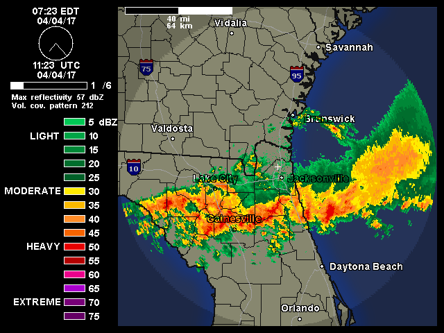
Significant Training occurring over the N FL Peninsula over Gainesville/Ocala. Multiple Severe T Storm and Tornado Warnings since this morning. Hot over Central and South Florida. Low to mid 90s yesterday- up to 95 at Tampa Vandenberg and Plant City Stations, and I walked to Tampa Bay just north of the pier and got some nice video of the strong gusty winds in the 30 mph gust range along with some choppy waves in the Bay. Breezy and warm again today and much cooler later this week. Thursday looks like a great beach day for those that love big surf-obviously there will be a rip current threat so be careful.
345 PM Update: Lots of thunderstorms developing over interior Central and North FL Peninsula with 2 Severe Thunderstorm Warnings. Going to be a very active afternoon interior and northeast of Tampa. Dry on the West Coast- all the rain is well NE of me. Oh well only 2 more months of very dry weather until the rainy season.
530 PM Update: Lots of storms firing up in a line along the west coast seabreeze north of Tampa. Still very dry over Tampa/St Pete and most of W Central Florida from Tampa Bay South. There is a distinct outflow boundary moving into NE Hillsborough county but no storms developing along it at this time, because the most favorable dynamics for storm development seem to be north of Tampa.
For Thursday- SPC has placed Central FL in a Marginal Risk w/ Slight to Mod Risk over N FL. I think Wednesday Night and early Thursday Morning we will see a line of thunderstorms a few of which may go severe mainly North of Tampa. Meanwhile, N FL and AL look like they are going to get a significant severe weather outbreak.
345 PM Update: Lots of thunderstorms developing over interior Central and North FL Peninsula with 2 Severe Thunderstorm Warnings. Going to be a very active afternoon interior and northeast of Tampa. Dry on the West Coast- all the rain is well NE of me.
530 PM Update: Lots of storms firing up in a line along the west coast seabreeze north of Tampa. Still very dry over Tampa/St Pete and most of W Central Florida from Tampa Bay South. There is a distinct outflow boundary moving into NE Hillsborough county but no storms developing along it at this time, because the most favorable dynamics for storm development seem to be north of Tampa.
For Thursday- SPC has placed Central FL in a Marginal Risk w/ Slight to Mod Risk over N FL. I think Wednesday Night and early Thursday Morning we will see a line of thunderstorms a few of which may go severe mainly North of Tampa. Meanwhile, N FL and AL look like they are going to get a significant severe weather outbreak.
Last edited by Tampa Bay Hurricane on Tue Apr 04, 2017 4:46 pm, edited 3 times in total.
0 likes
-
AdamFirst
- S2K Supporter
- Posts: 2487
- Age: 34
- Joined: Thu Aug 14, 2008 10:54 am
- Location: Port Saint Lucie, FL
Re: Florida Weather
Definite summertime-like pattern with thunderstorms developing inland and pushing toward the coast. Severe warned storms currently over Osceola/Brevard and Indian River County, with discreet cells and pop up showers stretching all the way down into inland Palm Beach and Hendry Counties.
0 likes
Dolphins Marlins Canes Golden Panthers HEAT
Andrew 1992 - Irene 1999 - Frances 2004 - Jeanne 2004 - Wilma 2005 - Fay 2008 - Isaac 2012 - Matthew 2016 - Irma 2017 - Dorian 2019 - Ian 2022 - Nicole 2022
Andrew 1992 - Irene 1999 - Frances 2004 - Jeanne 2004 - Wilma 2005 - Fay 2008 - Isaac 2012 - Matthew 2016 - Irma 2017 - Dorian 2019 - Ian 2022 - Nicole 2022
Re: Florida Weather
Got back to Orlando from S FL this afternoon, happy to see the rain in my area in Seminole County, we needed it badly.
0 likes
Return to “USA & Caribbean Weather”
Who is online
Users browsing this forum: Coldandsnow, dfw_toadie and 71 guests