Florida Weather

U.S. & Caribbean Weather Discussions and Severe Weather Events

Moderator: S2k Moderators

Forum rules

The posts in this forum are NOT official forecast and should not be used as such. They are just the opinion of the poster and may or may not be backed by sound meteorological data. They are NOT endorsed by any professional institution or STORM2K.

Help Support Storm2K
Message
Author
User avatar
TheStormExpert
Category 5
Category 5
Posts: 8487
Age: 30
Joined: Wed Feb 16, 2011 5:38 pm
Location: Palm Beach Gardens, FL

Re: Florida Weather

#9561 Postby TheStormExpert » Tue Mar 03, 2015 10:48 pm

SouthFloridian92 wrote:Too hot, I miss the cold! One thing I'm looking forward to as we head into the spring is that the snowbirds will finally start going back up north.

I know the cool/cold weather was enjoyable, but 4-5 weeks straight of it was plenty for me this winter. Most folks in Florida(especially S. FL) usually cave after a few days of the cool/cold weather! By the looks of things the cool weather doesn't seem likely at all to return in the future while it still can before it's too late. The pattern has shifted to a SW trough and ridge in the SE(known as the W. Atlantic/Bermuda High). With a +NAO, +AO, and -PNA all unfavorable for cold in the extreme SE U.S. my guess is winter is surely 97% over. Also the NPO(North Pacific Oscillation) is going into a phase that keeps the cold air now bottled up in Canada so that should bring much desperate relief for places like Boston, the NE, and the Midwest which have had yet another awful winter like last year.
0 likes   
The following post is NOT an official forecast and should not be used as such. It is just the opinion of the poster and may or may not be backed by sound meteorological data. It is NOT endorsed by storm2k.org.

User avatar
northjaxpro
S2K Supporter
S2K Supporter
Posts: 8900
Joined: Mon Sep 27, 2010 11:21 am
Location: Jacksonville, FL

#9562 Postby northjaxpro » Fri Mar 06, 2015 7:28 am

Cold front came through at around 3 a.m this morning, and for at least the next 36 hours, a decent cool spell has commenced here. After near record highs this week, temps will be quite chilly today here as brisk northeast winds and overcast conditoions will keep temps way down. Temp was 62 degrees at 2.a.m. now it is 49.4 degrees currently at my locale, and temps should hold steady or fall slowly all day. Don't think we will see a freeze here across Northeast Florida, although skies will clear tonight as High Pressure builds in the region. Due to the orientation of the High Pressure and onshore flow, although interior colder locales across the Suwannee River Valley and Big Bend may get close to the freeze mark. Only expecting upper 30s for the Jax area tomorrow morning, then temps moderate the rest of the weekend going into next week. Quick peek at the long range suggest quite a wet pattern may be setting up across the peninsula. More later.

This currently may be the last significant cooldown we will see as Spring really kicks into gear. I registered a max of 86 degrees yesterday. Amazing.
0 likes   
NEVER, EVER SAY NEVER in the tropics and weather in general, and most importantly, with life itself!!

________________________________________________________________________________________

Fay 2008 Beryl 2012 Debby 2012 Colin 2016 Hermine 2016 Julia 2016 Matthew 2016 Irma 2017 Dorian 2019

psyclone
S2K Supporter
S2K Supporter
Posts: 4488
Joined: Wed Aug 24, 2005 9:04 pm
Location: palm harbor fl

#9563 Postby psyclone » Fri Mar 06, 2015 11:41 am

extended outlooks are showing above normal temps and precip. so much for the fantastic march weather featuring 70's for highs and 50's to low 60's for lows...some of my very favorite weather to enjoy under a strengthening sun angle. perhaps the combo of above normal temps and precip will yield some interesting weather in the form of a heavy rain or svrwx potential...tis the season.
0 likes   

User avatar
NDG
S2K Supporter
S2K Supporter
Posts: 14933
Joined: Sun Jul 09, 2006 10:14 pm
Location: Orlando, FL

Re: Florida Weather

#9564 Postby NDG » Sun Mar 08, 2015 7:31 pm

I guess we can say Spring is officially here in central FL had to mow my grass for the first time this year ;)

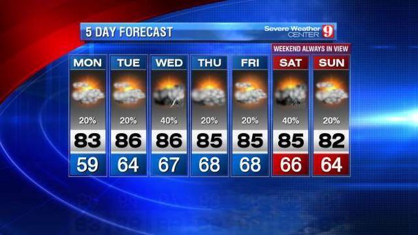
Is actually going to feel more like mid to late spring than early Spring this week coming up with temps getting into the mid 80s along with lots of humidity afternoon pop up summer like showers are not out of the question.

Image
0 likes   

HURRICANELONNY
Category 5
Category 5
Posts: 1381
Joined: Wed May 07, 2003 6:48 am
Location: HOLLYWOOD.FL

Re: Florida Weather

#9565 Postby HURRICANELONNY » Mon Mar 09, 2015 3:22 pm

Well maybe in about a week temps will get a little cooler but down here i'm not counting on it.

By early next week...long range models hint at a closed
500 mb low surging from the Great Lakes southeastward and into the
Appalachians. This trajectory is then depicted to push a cold
front through the Florida Peninsula. As expected this far
out...there are timing issues with the European model (ecmwf) about 24 hours faster
than the GFS in clearing the front through South Florida.
0 likes   
hurricanelonny

User avatar
FireRat
Category 5
Category 5
Posts: 1138
Age: 36
Joined: Sun Sep 26, 2010 11:38 pm
Location: North Carolina

Re: Florida Weather

#9566 Postby FireRat » Tue Mar 10, 2015 9:22 am

Before then, we can expect Summer-like temperatures (particularly the lows) over at least the next 3-5 days in South Florida. One could even argue that Summer has already begun down here, lows have been in the low 70s for quite some time now and they're forecast to be even warmer tonight and over the next few days, with lows around 75. Highs in the mid to upper 80s. :sun:
0 likes   
Georges '98, Irene '99, Frances '04, Jeanne '04, Katrina '05, Wilma '05, Gustav '08, Isaac '12, Matthew '16, Florence '18, Michael '18, Ian '22

HURRICANELONNY
Category 5
Category 5
Posts: 1381
Joined: Wed May 07, 2003 6:48 am
Location: HOLLYWOOD.FL

#9567 Postby HURRICANELONNY » Tue Mar 10, 2015 12:05 pm

Yup. Summer around the corner down here. All the front going to do is bring it back to normal next week. :roll:
0 likes   
hurricanelonny

psyclone
S2K Supporter
S2K Supporter
Posts: 4488
Joined: Wed Aug 24, 2005 9:04 pm
Location: palm harbor fl

#9568 Postby psyclone » Tue Mar 10, 2015 12:15 pm

A retreat back to normal would be a significant cool down compared to the near record warmth we're currently getting. it's like we went from winter chill to May in a week. I love the typical march weather and hope we get some. today areas away from the coast will be nearing 90. As of now our highs are forecast to drop back into the 70's next week. I hope that's correct..
0 likes   

User avatar
TheStormExpert
Category 5
Category 5
Posts: 8487
Age: 30
Joined: Wed Feb 16, 2011 5:38 pm
Location: Palm Beach Gardens, FL

#9569 Postby TheStormExpert » Tue Mar 10, 2015 2:31 pm

:uarrow: Definitely quite warm for this time of year(Early-Mid March). Though Spring Breakers and those in general looking to escape the wrath of Winter won't mind it at all! :sun:

Image

Image

Image
0 likes   
The following post is NOT an official forecast and should not be used as such. It is just the opinion of the poster and may or may not be backed by sound meteorological data. It is NOT endorsed by storm2k.org.

User avatar
NDG
S2K Supporter
S2K Supporter
Posts: 14933
Joined: Sun Jul 09, 2006 10:14 pm
Location: Orlando, FL

Re: Florida Weather

#9570 Postby NDG » Tue Mar 10, 2015 3:21 pm

Today's 12z model runs only show a slight cool down for next back to near average to a few degrees above average.
0 likes   

HURRICANELONNY
Category 5
Category 5
Posts: 1381
Joined: Wed May 07, 2003 6:48 am
Location: HOLLYWOOD.FL

#9571 Postby HURRICANELONNY » Tue Mar 10, 2015 5:00 pm

Yup but I think the dew will be down as well as night temps. That's all we get this time of year. :roll:
0 likes   
hurricanelonny

User avatar
FireRat
Category 5
Category 5
Posts: 1138
Age: 36
Joined: Sun Sep 26, 2010 11:38 pm
Location: North Carolina

Re: Florida Weather

#9572 Postby FireRat » Tue Mar 10, 2015 7:47 pm

Well, I guess we will see what happens next week! :wink:
Back to average sounds great...especially now with this intensifying sunshine, mid 80's feel quite hot!

Those are some impressive numbers up in Cfla, wow!...and I thought we were baking here with our 82 - 84 degree temps, man. 91 in the Tampa area, that's very hot indeed.
Ahhh, the simmer of Summer! :P
0 likes   
Georges '98, Irene '99, Frances '04, Jeanne '04, Katrina '05, Wilma '05, Gustav '08, Isaac '12, Matthew '16, Florence '18, Michael '18, Ian '22

User avatar
TheStormExpert
Category 5
Category 5
Posts: 8487
Age: 30
Joined: Wed Feb 16, 2011 5:38 pm
Location: Palm Beach Gardens, FL

#9573 Postby TheStormExpert » Tue Mar 10, 2015 8:15 pm

Not everyday do we get a "Backdoor Front". All these usually do is bring us back down to average or slightly below average with the humidity and dew points being the main difference bringing more a comfortable feel to the air. A good example is the very late season "Backdoor Front" from early last June which bought abnormally low dew points to the FL peninsula. Very impressive for that time of year!

AREA FORECAST DISCUSSION
NATIONAL WEATHER SERVICE MIAMI FL
309 PM EDT TUE MAR 10 2015

...WARM AND BREEZY THROUGH THE END OF THE WEEK...

.DISCUSSION...
SPRAWLING MID-LEVEL HIGH PRESSURE EXTENDING FROM THE SUBTROPICAL
WESTERN ATLANTIC ACROSS FLORIDA WILL REMAIN LOCKED IN PLACE
THROUGH THE REST OF THE WORK WEEK AND INTO THE WEEKEND AS LARGE
AND STRONG MID-LEVEL TROUGH OVER THE SOUTHERN PLAINS AND NORTHERN
MEXICO REMAINS NEARLY STATIONARY. THIS WILL RESULT IN DEEP LAYERED
HIGH PRESSURE INFLUENCING SOUTH FLORIDA WITH WARM AND BREEZY
CONDITIONS THROUGH MOST OF THE FORECAST PERIOD.

SHORT TERM (TONIGHT THROUGH THURSDAY NIGHT)...
FAIR CONDITIONS ONGOING THIS AFTERNOON WILL CONTINUE THROUGH
TONIGHT, EXCEPT FOR ISOLATED SHOWERS SOUTH/WEST OF LAKE
OKEECHOBEE WHERE SOME LOW LEVEL CONVERGENCE BETWEEN THE PREVAILING
SE FLOW AND WEAK GULF SEA BREEZE WILL TAKE PLACE. SLIGHT CHANCE OF
SHOWERS OVERNIGHT ALONG THE EAST COAST BUT ALL IN ALL A DRY NIGHT
IS IN STORE. SOME PATCHY FOG IS POSSIBLE, TONIGHT BUT THIS SHOULD
BE CONFINED TO AREAS WEST OF LAKE OKEECHOBEE. WEDNESDAY SHOULD BE
THE "LEAST DRY" DAY OF THE WEEK AS A WEAK IMPULSE IN THE DEEP
LAYERED SOUTHERLY FLOW MOVES ACROSS THE AREA AND MOISTURE LEVELS
INCREASE JUST ENOUGH. MODEL SOUNDINGS SHOW ENOUGH INSTABILITY OVER
THE INTERIOR AND GULF COAST IN THE AFTERNOON TO SUPPORT A SLIGHT
CHANCE OF THUNDERSTORMS AS TEMPERATURES RISE INTO THE UPPER 80S.
THE MID-LEVEL HIGH MOVES CLOSER TO FLORIDA ON THURSDAY WHICH
SHOULD PROVIDE ENOUGH SUBSIDENCE/DRYING TO LIMIT POPS TO NO MORE
THAN 20% AREA-WIDE. WARMEST TEMPERATURES OF THE PERIOD SHOULD BE
WEDNESDAY WITH HIGHS NEAR 90 IN THE TYPICAL WARM SPOTS OVER THE
BIG CYPRESS/EVERGLADES, WITH MID/UPPER 80S AREA-WIDE ON THURSDAY.

LONG TERM (FRIDAY INTO EARLY NEXT WEEK)...
THE STRONG HIGH PRESSURE FINALLY SHOWS SIGNS OF BREAKING DOWN AS A
STRONG SHORTWAVE TROUGH DROPS INTO THE GREAT LAKES/NE UNITED
STATES. LITTLE CHANGE IN SENSIBLE WEATHER ON FRIDAY, THEN FOR THE
UPCOMING WEEKEND THE SOUTHEAST FLOW WILL WEAKEN. THIS WILL LIKELY
LEAD TO MORE OF A DAILY SEA-BREEZE INFLUENCE ALONG WITH SLIGHTLY
GREATER INSTABILITY. A CHANCE OF SHOWERS IS IN THE FORECAST FOR
THE WEEKEND, HIGHEST INTERIOR AND AROUND LAKE OKEECHOBEE.
ATMOSPHERE OVER THE INTERIOR COULD BE UNSTABLE ENOUGH FOR A FEW
TSTMS, ESPECIALLY ON SUNDAY, BUT FOR NOW DECIDED NOT TO INCLUDE IN
THE FORECAST. GLOBAL MODELS (MAINLY GFS/ECMWF) SHOW A "BACKDOOR
FRONT"
SLIDING DOWN THE FLORIDA PENINSULA LATE SUNDAY AND MONDAY,
WHICH WOULD BE THE FIRST FRONT OF ANY KIND IN OVER A WEEK. WINDS
SHOW A WIND SHIFT TO THE N/NE ALONG WITH COOLER TEMPERATURES (NEAR
NORMAL) POSSIBLE BY THE END OF THIS FORECAST PERIOD.
0 likes   
The following post is NOT an official forecast and should not be used as such. It is just the opinion of the poster and may or may not be backed by sound meteorological data. It is NOT endorsed by storm2k.org.

HURRICANELONNY
Category 5
Category 5
Posts: 1381
Joined: Wed May 07, 2003 6:48 am
Location: HOLLYWOOD.FL

Re: Florida Weather

#9574 Postby HURRICANELONNY » Tue Mar 10, 2015 8:49 pm

I read the discussion about everyday. Good memory back in June. That was a nice week. :D
0 likes   
hurricanelonny

psyclone
S2K Supporter
S2K Supporter
Posts: 4488
Joined: Wed Aug 24, 2005 9:04 pm
Location: palm harbor fl

#9575 Postby psyclone » Wed Mar 11, 2015 10:11 am

The long range outlooks are tilting back to and below normal for the eastern US. Our March weather is probably going to show...just a bit late. In the interim the May preview continues with unseasonably (dare I say) borderline hot weather with afternoon/evening seabreeze driven convection tossed in for good measure.
0 likes   

User avatar
TheStormExpert
Category 5
Category 5
Posts: 8487
Age: 30
Joined: Wed Feb 16, 2011 5:38 pm
Location: Palm Beach Gardens, FL

#9576 Postby TheStormExpert » Wed Mar 11, 2015 10:36 am

Talk about some very abnormally high Dewpoints this morning thanks to a very moist and tropical Southeasterly flow bringing in hit and miss showers along with it. Feels like mid/late summer out there!
:raincloud:

Image

Image

Image

And psyclone, it seems to be very questionable still whether or not we will manage to get into some below average temperatures for the peninsula as we had into late March, still would not completely rule out a late season strongish cold front if the PNA can go positive again which looks to happen during the next two weeks.

Image
0 likes   
The following post is NOT an official forecast and should not be used as such. It is just the opinion of the poster and may or may not be backed by sound meteorological data. It is NOT endorsed by storm2k.org.

User avatar
NDG
S2K Supporter
S2K Supporter
Posts: 14933
Joined: Sun Jul 09, 2006 10:14 pm
Location: Orlando, FL

Re: Florida Weather

#9577 Postby NDG » Wed Mar 11, 2015 5:30 pm

Officially Orlando hit 90 degrees for the first time this year, not a record which was missed by one degree. Last time we hit 90, exactly 5 months ago.

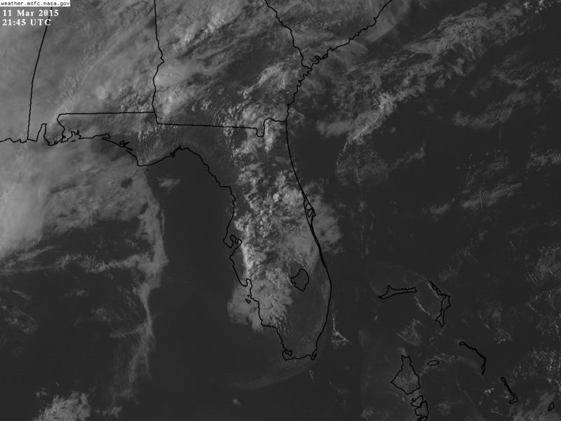
Combined with high humidity and seabreeze fronts thunderstorms popped up this afternoon across the interior areas.

Image
0 likes   

User avatar
gatorcane
S2K Supporter
S2K Supporter
Posts: 23499
Age: 46
Joined: Sun Mar 13, 2005 3:54 pm
Location: Boca Raton, FL

#9578 Postby gatorcane » Wed Mar 11, 2015 7:15 pm

Yeah NDG, certainly a summer-time pattern across the peninsula today. We can get these types of days in March from time-to-time, as we transition into the summer-pattern. Of course there will be a front that will sweep through that will end this pattern and we will have to wait until end-of-May until the true beginning of the rainy season.

Here along the coast in SE Florida, temps are still on the cool and pleasant side with steady E to ESE winds coming in. With the Atlantic SSTs offshore in the upper 70s, it doesn't get too warm in the day here yet, around 83F-84F for highs the past couple of days. Overnight lows generally around 75-76F.
0 likes   

User avatar
northjaxpro
S2K Supporter
S2K Supporter
Posts: 8900
Joined: Mon Sep 27, 2010 11:21 am
Location: Jacksonville, FL

#9579 Postby northjaxpro » Wed Mar 11, 2015 8:25 pm

:uarrow: It certainly was a summer-like day here today. 87 degrees was the max at my locale today and received a thunderstorm after 6:00 this evening, dropping about 2/3 of an inch of rain. Well, I am definitely ready for the Spring weather, but I echo the thoughts of others that it is just a bit early to be experiencing near 90 degree heat in mid March. We are about a month early regarding that.

The rain is good though in that this is typically our dry season. I will follow back later will a summary of the Fall/Winter 2014-15 season, which overall ended up just a bit warmer than average here in Jacksonville, with the exceptions of the record arctic outbreak in November and again in February, with a surprise light ocean effect snow event in between.
0 likes   
NEVER, EVER SAY NEVER in the tropics and weather in general, and most importantly, with life itself!!

________________________________________________________________________________________

Fay 2008 Beryl 2012 Debby 2012 Colin 2016 Hermine 2016 Julia 2016 Matthew 2016 Irma 2017 Dorian 2019

User avatar
TheStormExpert
Category 5
Category 5
Posts: 8487
Age: 30
Joined: Wed Feb 16, 2011 5:38 pm
Location: Palm Beach Gardens, FL

#9580 Postby TheStormExpert » Wed Mar 11, 2015 9:34 pm

Still have some showers and storms going across inland North/Central Florida at this hour.

Image

Image
0 likes   
The following post is NOT an official forecast and should not be used as such. It is just the opinion of the poster and may or may not be backed by sound meteorological data. It is NOT endorsed by storm2k.org.


Return to “USA & Caribbean Weather”

Who is online

Users browsing this forum: 869MB, Brent, Coldandsnow, ravyrn, snownado, txtwister78 and 105 guests