Page 634 of 880
Re: Florida Weather
Posted: Sun Apr 15, 2018 2:03 pm
by northjaxpro
First Severe Thunderstorm Warning today for this area of Northeast Florida.
__________________________________________________________________
The National Weather Service in Jacksonville has issued a
* Severe Thunderstorm Warning for...
Nassau County in northeastern Florida...
Northwestern St. Johns County in northeastern Florida...
Clay County in northeastern Florida...
Duval County in northeastern Florida...
* Until 330 PM EDT.
* At 245 PM EDT, severe thunderstorms were located along a line
extending from Bryceville to Cecil Field to near Interlachen,
moving northeast at 50 mph.
HAZARD...70 mph wind gusts.
SOURCE...Radar indicated.
IMPACT...Expect considerable tree damage. Damage is likely to
mobile homes, roofs, and outbuildings.
* Locations impacted include...
Jacksonville, Orange Park, Green Cove Springs, Hilliard, Callahan,
Jacksonville International Arpt, Mandarin, Fruit Cove, Arlington
and Middleburg.
PRECAUTIONARY/PREPAREDNESS ACTIONS...
For your protection move to an interior room on the lowest floor of a
building.
Torrential rainfall is occurring with these storms, and may lead to
flash flooding. Do not drive your vehicle through flooded roadways.
Re: Florida Weather
Posted: Sun Apr 15, 2018 2:12 pm
by northjaxpro
NWS Jax radar is indicating possible rotation in a very intense cell just north of me across the state line up in Camden County in Southeast Georgia near Woodbine.
EDIT: Yes, NWS now has issued Tornado Warning for that area.
Re: Florida Weather
Posted: Sun Apr 15, 2018 2:42 pm
by ava_ati
Just went through the initial gust front in world golf village, estimated 50 to 60 mph gusts for 2 minutes at the most, no hail. Radar shows us just now getting into the red it is hard not to let your guard down because the initial gusts were pretty butt puckering.
Re: Florida Weather
Posted: Sun Apr 15, 2018 2:47 pm
by northjaxpro
I have already measured over 2 and 1/4 inches of rain in just over 40 minutes. I also had a gust to 52 mph. Still raining moderately at this time. No hail fell that I can report on from my locale. However, what a drenching of rain in such a short time. This reminded of what a summer thunderstorm could typically bring to us during our rainy season. Impressive!
Re: Florida Weather
Posted: Sun Apr 15, 2018 3:05 pm
by psyclone
picked up a little over 1" here with the main heavy rain. performance as expected. Looking for a rare mid april day with sub 70 highs tomorrow. Spectacular weather incoming
Re: Florida Weather
Posted: Sun Apr 15, 2018 3:10 pm
by northjaxpro

That's right psyclone. Mid 40s expected here the next couple of mornings. Max temps tomorrow only in the upper 60s at best! Temps running 10-15 degrees below average the next couple of days. Brisk northwest winds tomorrow will add to the coolness in the air. Normal high temp for April 16 is 80 degrees at JAX and the normal low is 56. I can not remember such a cooler than average meteorological spring we are having here in 2018. I measured 2 freezes in March, and have had several mornings well down into the 40s here in April, with a couple of more coming up the next couple of days. The -NAO is certainly the chief reason. But, I am happy to see this rain as it was needed so badly with the dry pattern we have had mostly to this juncture.
Re: Florida Weather
Posted: Sun Apr 15, 2018 3:32 pm
by northjaxpro
That intense line of storms that moved through Jax and Northeast Florida has now moved off the coast, and the severe weather threat now has primarily ended here for now. There may still be a chance of developing intense storm cells down over the central and southern peninsula the next few hours as the cold front pushes down the peninsula into this evening.
Re: Florida Weather
Posted: Sun Apr 15, 2018 7:33 pm
by StormingB81
Here in rockledge it rained for a total of 3 minutes and that was it. Didnt get anything
Re: Florida Weather
Posted: Sun Apr 15, 2018 10:42 pm
by JaxGator
Well the squall line moved through as fast as it arrived. The severe thunderstorm warnings that NWS Jax issued said the squall line was moving at about 50 mph, so it was fast for sure. Though we got about an inch + of rain and wind from the gust front that came through. The line thankfully weakened before it got to my locale, as there wasn't that much lightning as their was, but it did pack a punch as it quickly moved through. Now that the cold front has moved through, I'm looking forward to having nice below average crisp temps to start the week. Lows in the upper 40s with highs in the upper 60s and lower 70s tomorrow. Same case for Tuesday.
Re: Florida Weather
Posted: Mon Apr 16, 2018 10:25 am
by northjaxpro
Good morning!
Well, it measured 47 degrees here at my locale earlier this morning. It was even colder in locations further inland with lower 40s over the Suwannee River Valley and over the Big Bend region. Tallahassee had 42 degrees earlier today. Crestview out in the panhandle dropped to 37 degrees this morning.
Good cold air advection day in progress with brisk northwest winds. Currently 55 degrees this hour. NWS has adjusted their max temps forecast for this afternoon. They are now only calling for low-mid 60s . Temps are forecast to drop into the lower 40s colder inland locales over the northern peninsula tomorrow morning.
Re: Florida Weather
Posted: Mon Apr 16, 2018 11:05 am
by gatorcane
Yeah this is an impressive front for this time of year indeed Jax. Got to think this will be the last real cool down for the state particular South Florida until mid to late October. Also it is good news we got so much rain across the state from this front as it definitely should help with de-escalating fire concerns for the time being. Still got to watch things as we head into May because the start of the rainy season is still about five weeks away or so not to mention temps should be creeping higher close or into the 90s as we head into May. Any delay in the rainy season start could also be a concern.
Re: Florida Weather
Posted: Mon Apr 16, 2018 12:25 pm
by ava_ati
gatorcane wrote:Yeah this is an impressive front for this time of year indeed Jax. Got to think this will be the last real cool down for the state particular South Florida until mid to late October. Also it is good news we got so much rain across the state from this front as it definitely should help with de-escalating fire concerns for the time being. Still got to watch things as we head into May because the start of the rainy season is still about five weeks away or so not to mention temps should be creeping higher close or into the 90s as we head into May. Any delay in the rainy season start could also be a concern.
Just not sure we are going to get out of this pattern any time soon, looks like another Low pressure system is going to drop down into our region next Sunday/Monday... With temps behind it 20 degrees below normal.
Re: Florida Weather
Posted: Mon Apr 16, 2018 1:12 pm
by gatorcane
Yeah I see this feature showing up on the models. I may have spoken too soon, perhaps one more cool down in store. But the pattern is definitely one of troughing unlike last year where we saw some persistent ridging and east wind pattern mostly dominate in the spring-time. Maybe we will end up with a significant rainy season in South Florida if we can get more days with SW wind flow to steer the activity to the East Coast Metro areas.
Re: Florida Weather
Posted: Mon Apr 16, 2018 3:35 pm
by psyclone
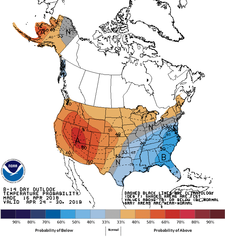
The joy of a late "winter" continues. exquisite weather today with more on tap this week. and the 8-14 and 6-10 day outlooks are tilting cooler and wetter than normal
Re: Florida Weather
Posted: Mon Apr 16, 2018 6:49 pm
by northjaxpro
I took the time to examine the latest runs. Looking long range, GFS and EURO both have general shortwave troughing across the Eastern CONUS right on through the rest of this month. Both models are also showing the potential of strong shortwaves traversing along the southern stream jet the next couple of weeks. This would explain the potential wetter pattern the next couple of weeks as well. This would be good news in that if we get the southern jet stream active, that would really help even more in relieving the dry conditions across the rest of the peninsula.
Overall, cooler than average and the potential bonus of wetter than average could be on tap the rest of this month. We may get through April here at my locale without measuring 90 degrees. Generally, we see our first 90 degree day by mid-April. So far, 88 degrees is the warmest temp I have measured to this juncture. The NAO is still negative. It looks to stay negative potentially into the first week of May. It has been a fantastic spring for yours truly with having absolutely low electric bills for sure due to the cooler than average weather we are having!
Re: Florida Weather
Posted: Mon Apr 16, 2018 6:56 pm
by psyclone
Today's high of 69 at Tampa was 6 degrees lower than the "coldest" high in February.
Re: Florida Weather
Posted: Mon Apr 16, 2018 7:00 pm
by northjaxpro
The max here today at my locale measured at 67.4 degrees, which is 13 degrees below average for today's date here for Jacksonville. This gives perspective how much cooler than average we are currently.
It is expected to drop into the low 40s colder locations across this area by tomorrow morning.
Just imagine how lucky we ended up being again having this -NAO occur during the height of the meteorological spring, as opposed to happening during the dead of the winter months. Amazing...
Also, to follow-up psyclone on the 8-14 day NOAA temperature outlook. This definitely continues outlining the story for sure.
Re: Florida Weather
Posted: Tue Apr 17, 2018 6:01 am
by northjaxpro
High Pressure axis right over the peninsula this morning. Winds are light to calm over the state this morning with clear skies. Good radiational cooling conditions. Chilly this morning. It is 42.3 degrees currently.at my locale. Cecil Commerce automated station, which is the cold air drainage spot in the Jax metro area on the western portion of Duval County, is reporting 37 degrees this hour.
Temps will moderate to slightly above average beginning Wednesday as southwest wind flow will get max temps into the low-mid 80s by Thursday. However, a dry, cool front brings northeast winds and drops through North Florida on Friday, which will bring temps back down to just slightly below average for the weekend.
The next round of rain and thunderstorms returns over the area Sunday into Monday. This is due to another potent shortwave, which will be traversing the Northern GOM and the Deep South region.
The models are hinting at possible heavy rain, which could be in store for the area, especially North Florida into Monday of next week.
Re: Florida Weather
Posted: Thu Apr 19, 2018 7:11 am
by NDG
Good thing this pattern is happening now in the spring than in the middle of winter. The weird thing is that we have a mostly neutral to positive NAO and mostly -PNA since late March.
Despite that it seems "cooler" the Orlando area has averaged 2 degrees F above average so far this month and March was only 1.8 degrees F below average.
Because of the high strong sun angle we here in the interior of central FL heat up back into the upper 80s right away.
Re: Florida Weather
Posted: Thu Apr 19, 2018 10:51 am
by gatorcane
Still has a "spring-like" feel across South Florida with another front moving into the area in a few days. Hard to believe that in just about a month from now, the rainy season will be upon us with the unbearable humidity. So enjoy it while you can!