Page 689 of 880

Re: Florida Weather

Posted: Sat Jan 05, 2019 8:59 pm
by psyclone
TheStormExpert wrote:
psyclone wrote:CPC showing normal temps and precip over the next 2 weeks with no significant below normal anomalies anywhere in the continental US.

One thing I must say about the CPC's Precipitation Outlook is they have frequently busted for S.FL in forecasting above normal precipitation many times throughout the past several months, we have seen little to no precipitation in the past few months.


But there's been a very sharp demarcation between the haves and the have nots..impossible to get that granular in long term outlooks and most of the southeast is a swamp, east central and southeast florida notable exceptions. The temp forecasts have definitely been on point lately and they are not suggestive any cold blast yet..

Re: Florida Weather

Posted: Sun Jan 06, 2019 9:30 am
by northjaxpro
42 degrees this morning with clear skies. We are sitting exactly on what our average minimum temperature for January 7 should be.

Temps will be at our seasonable averages for this coming week. A dry cold front moves through the peninsula mid week, but as I mentioned yesterday, the polar HP will move east, keeping the core of the arctic air well north of Florida.

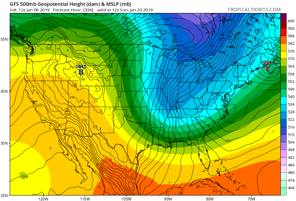
The long range models are still trying to grasp the large scale 500 mb pattern over North America over the next 10-14 days. However, since yesterday, the GFS, GFS FV3, UKMET, and EURO are gradually showing increasing heights over the Pacific/ U.S. West Coast/ Western Canada after 240 hours. This as far as I am concerned is among the biggest potential harbinger of Old Man Winter's return to the Central and Eastern CONUS down the road.

I am observing this very closely as the MJO phase cycle is nearing its apex currently, and we should be seeing a pattern change coming across the continent before this month ends. I am watching to see if a stronger +PNA materializes by week beginning January 20.

Teleconnections have to come together in a special alignment for those wanting a real good cold spell in this part of the country. + PNA , -AO, -NAO trifecta would really usher Old Man Winter in grand style.

I don't want it that harsh though for potential record breaking cold. I would be content with +PNA, -AO with a neutral NAO. This was the particular set-up we had during the January 3, 2018 winter storm we had just north of me up in Southeast GA just a year ago.

So keep an eye out in the long range to see if 500 mb ridging out west in the Pacific region keeps being hinted.

Well, since I have a track record of sticking my neck out at times on the forum here with some modest success LoL... :wink:

I will say this now: My gut tells me the week beginning January 20 will bring a potential very cold period across the CONUS east of the Rockies......

Well, I will see later if I will be left hanging precariously on the proverbial tree branch for this. Lol... :lol:

Re: Florida Weather

Posted: Sun Jan 06, 2019 1:45 pm
by gatorcane
northjaxpro wrote:
So keep an eye out in the long range to see if 500 mb ridging out west in the Pacific region keeps being hinted.

Well, since I have a track record of sticking my neck out at times on the forum here with some modest success LoL... :wink:

I will say this now: My gut tells me the week beginning January 20 will bring a potential very cold period across the CONUS east of the Rockies......


Well the GFS and FV3 GFS are now showing a deep trough during this timeframe. :cold: The models didn’t get the pattern right for this weekend as it was supposed to be much colder. So we will see if the models continue to go with this solution as we get closer or back off:
Image

Re: Florida Weather

Posted: Sun Jan 06, 2019 3:21 pm
by northjaxpro
:uarrow: Well, I did my analysis earlier this morning above prior to these latest 12Z runs today. I sensed that the long range models indeed would begin to latch onto the solution of deep troughing across the Eastern CONUS .

Now, let us see if the models can continue to hold onto the potential pattern change in the coming days. These long range models have been volatile lately. They can obviously change quickly.

Re: Florida Weather

Posted: Sun Jan 06, 2019 6:23 pm
by boca
The 18z GFS has backed off on the cold for Florida so let’s see if northjaxpro is going to be correct on his prediction.Im personally hoping for the pattern change for colder weather.

Re: Florida Weather

Posted: Sun Jan 06, 2019 9:24 pm
by FlaWeatherDude
Models are now predicting a good prolonged downwelling SSW PV split! If this downwelling is perfectly directed towards the E US, we could very well be talking about record cold as the interim wind reversal is at record levels past that of the January 85 SSW!!! :double:

Re: Florida Weather

Posted: Mon Jan 07, 2019 1:12 pm
by psyclone
Thursday's 60 degree high forecast will be 10 degrees below normal here if it holds. That looks like the coolest day this week.

Re: Florida Weather

Posted: Mon Jan 07, 2019 6:20 pm
by TheStormExpert
Perfect night out! Not too warm, not too cold, just right! Even with a easterly wind it’s still pleasant with dew points in the upper 50’s.

Re: Florida Weather

Posted: Tue Jan 08, 2019 7:11 am
by northjaxpro
The models have trended a bit colder for later this week as a 1040 mb Polar High, currently moving into the extreme Northern Plains, moves east Wednesday through Friday. MOS showing lower 30s across inland Northeast Florida by Thursday morning as breezy northwest winds advect colder temps into the region.

Moderation will begin by Friday as the HP shifts over the Canadian Martimes/New England region and the wind will become onshore across the peninsula.

Re: Florida Weather

Posted: Tue Jan 08, 2019 11:44 am
by psyclone
We've definitely got some chilly weather on the way. Wednesday night through Thursday night and then another invasion of chilly weather next week after a brief rebound for the weekend. The next week overall looks to average below normal here if the current forecast verifies.

Re: Florida Weather

Posted: Tue Jan 08, 2019 12:13 pm
by northjaxpro
:uarrow: I agree. I really believe within the next 2 weeks, we will finally be in the process of seeing the beginnings of the long anticipated colder weather pattern across North America, courtesy of the MJO phase apex and the sudden stratospheric warming event.

I am getting more confident with time about the prediction I made this past weekend ........

Re: Florida Weather

Posted: Tue Jan 08, 2019 9:39 pm
by HURRICANELONNY
They're still saying the second half of Jan and possible thru Feb.:
https://www.wbur.org/hereandnow/2019/01 ... 9-forecast
:roll:

Re: Florida Weather

Posted: Wed Jan 09, 2019 3:24 pm
by chaser1
HURRICANELONNY wrote:They're still saying the second half of Jan and possible thru Feb.:
https://www.wbur.org/hereandnow/2019/01 ... 9-forecast
:roll:


I'm thinking that'll likely be coming to fruition. With all the recent "Polar Vortex" talk lately and evidence of a rapid warming of the Stratosphere, it's only been during the past few days where evidence of these upper air changes have seemingly begun to work their way down to the Stratosphere (our layer where weather as we know it basically occurs). During the past couple weeks I've been eye-balling, waiting to see if I'd see some consensus with the major global models beginning to show any consistency with their N. Hemisphere 500mb long range forecasts and am pretty sure I'm finally seeing some real continuity now. Sure, it looks like we'll all feel a stronger cold front impacting all of Florida next week (Tue/Wed perhaps), but the real story looks to be about what will set up between the 18th-25th.

Really does look like the primary 500mb low pressure "lobe" (or vortex, but I'm beginning to hate that word), will actually shift south of the Arctic Circle and center itself over the Hudson Bay during that period of time. Depending on timing and at a point where the lowest 500 mb plot actually is centered over S. Hudson Bay, I'd say it's a pretty good bet that there will be at least a couple nights where N. Florida will experience low temps in the teens, and 30's will be felt throughout most of S. Florida. Just "how cold" or possibility of frozen precip will ultimately depend on a few other factors.
How long this pattern might stay in place or to what level could a secondary sub-tropical jet might play a role will be interesting to watch for.

Bottom line though is that I think a potentially frigid front will plow southward through Florida around Jan. 18th-20th, with a secondary (even colder?) front on it's heels by about the 25th. Might wanna start thinking about those sensitive orchids now.... just in case.

Re: Florida Weather

Posted: Wed Jan 09, 2019 4:16 pm
by northjaxpro
:uarrow: Chaser, pretty good assessment on the large scale pattern. I agree with much of what you stated above. The signs were being shown going back to last weekend with the long range models showing increasing 500 mb heights across the Pacific/U.S West Coast and Western Canada (potential +PNA) I stuck my neck out again predicting that the long awaited real cold pattern change (SSWE) would arrive by the week beginning January 20. I am feeling better each day about that. Long range models also picking up on ridging across Alaska also.

However, inside of 300 hours today, one thing I particularly see are models picking up on ridging over Greenland (potential -NAO) as well. The set up for a potential major cold outbreak across North America within the next two weeks. Colder times are indeed coming!! How much and to the extent of the cold is what we will find out as time progresses....

Re: Florida Weather

Posted: Wed Jan 09, 2019 5:07 pm
by FlaWeatherDude
these upper air changes have seemingly begun to work their way down to the Stratosphere (our layer where weather as we know it basically occurs)


You mean the Troposphere lol :P

Right now I think this SSW will be a share the wealth event where Europe gets the initial pole of cold mid-month then U.S./NA sometime late Jan-first half of Feb! :cold:

Re: Florida Weather

Posted: Wed Jan 09, 2019 5:48 pm
by floridasun78
look winter have come back this week cool down and next week cool down maybe winter now too stay as we go deeper in jan and into feb

Re: Florida Weather

Posted: Wed Jan 09, 2019 6:01 pm
by chaser1
FlaWeatherDude wrote:
these upper air changes have seemingly begun to work their way down to the Stratosphere (our layer where weather as we know it basically occurs)


You mean the Troposphere lol :P

Right now I think this SSW will be a share the wealth event where Europe gets the initial pole of cold mid-month then U.S./NA sometime late Jan-first half of Feb! :cold:


Thanks FlaWeatherdude :wink: . I used to never proof check my entries but have recently made a habit of doing so. Obviously twice is still not enough lol. You know.... for a few days I was starting to believe that Europe was going to get all the fun and we're going to get left out in the col.... ummm, "heat".

Re: Florida Weather

Posted: Wed Jan 09, 2019 6:39 pm
by psyclone
I'm not a buyer of big cold until it's on the way. As of now it isn't and I'd be skeptical. Looks like typical chilly winter weather is on the docket near term which will likely average out to a tad below normal. So far, the strawberry growers in Plant City have not needed to turn on the sprinklers this growing season and we have yet to have any meaningful freezes punch in to central Florida despite plenty of chilly nights. It's kind of a happy medium and it's a streak I'm sure many hope remains intact.

Re: Florida Weather

Posted: Wed Jan 09, 2019 7:53 pm
by chaser1
:uarrow: No doubt. A hard freeze would hurt a lot of people, not to mention raise the price of produce - big time. Personally, I'd be perfectly happy to have an extended period of 50's for highs and upper 30's for lows. As for Florida weather, many of us seldom get exactly what we want.

Re: Florida Weather

Posted: Wed Jan 09, 2019 9:09 pm
by psyclone
chaser1 wrote::uarrow: No doubt. A hard freeze would hurt a lot of people, not to mention raise the price of produce - big time. Personally, I'd be perfectly happy to have an extended period of 50's for highs and upper 30's for lows. As for Florida weather, many of us seldom get exactly what we want.


The strawberries can take quite the freeze provided the sprinklers work...but im hoping no test is needed. The big freeze potential down into the peninsula starts to drop off after mid feb...so if winter is going to show up it's going to need to reveal itself fairly soon. there's still time but we're entering the 2nd half.