Page 691 of 880
Re: Florida Weather
Posted: Fri Jan 11, 2019 6:14 pm
by psyclone
The newly issued 3-4 week outlook does show the entire eastern US favoring below normal.
Re: Florida Weather
Posted: Fri Jan 11, 2019 6:17 pm
by northjaxpro
psyclone wrote:The newly issued 3-4 week outlook does show the entire eastern US favoring below normal.
Yes indeed. It is about to get rather chilly to say the least, and for a prolonged period too, beginning next following week January 20.
Re: Florida Weather
Posted: Fri Jan 11, 2019 9:49 pm
by gatorcane
The 18Z GFS is MUCH colder:
Re: Florida Weather
Posted: Sat Jan 12, 2019 8:09 am
by gatorcane
Overnight model runs show the pattern turning much colder in the medium to long range.

Re: Florida Weather
Posted: Sat Jan 12, 2019 9:20 am
by northjaxpro
northjaxpro wrote:The long range models are still trying to grasp the large scale 500 mb pattern over North America over the next 10-14 days. However, since yesterday, the GFS, GFS FV3, UKMET, and EURO are gradually showing increasing heights over the Pacific/ U.S. West Coast/ Western Canada after 240 hours. This as far as I am concerned is among the biggest potential harbinger of Old Man Winter's return to the Central and Eastern CONUS down the road.
I am observing this very closely as the MJO phase cycle is nearing its apex currently, and we should be seeing a pattern change coming across the continent before this month ends.
I am watching to see if a stronger +PNA materializes by week beginning January 20. Teleconnections have to come together in a special alignment for those wanting a real good cold spell in this part of the country. + PNA , -AO, -NAO trifecta would really usher Old Man Winter in grand style.I don't want it that harsh though for potential record breaking cold. I would be content with +PNA, -AO with a neutral NAO. This was the particular set-up we had during the January 3, 2018 winter storm we had just north of me up in Southeast GA just a year ago.
So keep an eye out in the long range to see if 500 mb ridging out west in the Pacific region keeps being hinted.
Well, since I have a track record of sticking my neck out at times on the forum here with some modest success LoL... 
I will say this now: My gut tells me the week beginning January 20 will bring a potential very cold period across the CONUS east of the Rockies......
Well, I will see later if I will be left hanging precariously on the proverbial tree branch for this. Lol... 
The latest 06Z GFS shows a total of 3 polar frontal boudaries moving south through the Deep South and into Florida the week beginning January 20 - January 27. The cold surge in particular for January 25-27 really has the potential to be very cold for the peninsula. It also is looking like we will indeed have as close to a set-up of +PNA, -AO and -NAO by the end of this month. This set up does not happen often folks. We potentially could be looking at not only prolonged period of cold, but record cold temps as well.
I am feeling rather confident, with the reliable models all showing good consensus, that the long awaited cold pattern change is well underway now. It will be quite a prolonged period of cold too with the PV well established by this month's end.
It appears that I can breathe a bit easier now. I will not be left hanging precariously on that tree limb after all
I have been burned in this business more times than not through the years in making long range forecasts 10-14 days out. I can assure you! But, I have to admit, sticking my neck out at my own peril on Storm2K has really brought me some modest feathers for my cap in my over 8 years as a site member. I have had some gems on this site, and I can add this one now.
Now, can I work this mojo over towards winning the lottery
Re: Florida Weather
Posted: Sat Jan 12, 2019 10:39 am
by boca
northjaxpro wrote:northjaxpro wrote:The long range models are still trying to grasp the large scale 500 mb pattern over North America over the next 10-14 days. However, since yesterday, the GFS, GFS FV3, UKMET, and EURO are gradually showing increasing heights over the Pacific/ U.S. West Coast/ Western Canada after 240 hours. This as far as I am concerned is among the biggest potential harbinger of Old Man Winter's return to the Central and Eastern CONUS down the road.
I am observing this very closely as the MJO phase cycle is nearing its apex currently, and we should be seeing a pattern change coming across the continent before this month ends.
I am watching to see if a stronger +PNA materializes by week beginning January 20. Teleconnections have to come together in a special alignment for those wanting a real good cold spell in this part of the country. + PNA , -AO, -NAO trifecta would really usher Old Man Winter in grand style.I don't want it that harsh though for potential record breaking cold. I would be content with +PNA, -AO with a neutral NAO. This was the particular set-up we had during the January 3, 2018 winter storm we had just north of me up in Southeast GA just a year ago.
So keep an eye out in the long range to see if 500 mb ridging out west in the Pacific region keeps being hinted.
Well, since I have a track record of sticking my neck out at times on the forum here with some modest success LoL...
I will say this now: My gut tells me the week beginning January 20 will bring a potential very cold period across the CONUS east of the Rockies......
Well, I will see later if I will be left hanging precariously on the proverbial tree branch for this. Lol...
The latest 06Z GFS shows a total of 3 polar frontal boudaries moving south through the Deep South and into Florida the week beginning January 20 - January 27. The cold surge in particular for January 25-27 really has the potential to be very cold for the peninsula. It also is looking like we will indeed have as close to a set-up of +PNA, -AO and -NAO by the end of this month. This set up does not happen often folks. We potentially could be looking at not only prolonged period of cold, but record cold temps as well.
I am feeling rather confident, with the reliable models all showing good consensus, that the long awaited cold pattern change is well underway now. It will be quite a prolonged period of cold too with the PV well established by this month's end.
It appears that I can breathe a bit easier now. I will not be left hanging precariously on that tree limb after all
I have been burned in this business more times than not through the years in making long range forecasts 10-14 days out. I can assure you! But, I have to admit, sticking my neck out at my own peril on Storm2K has really brought me some modest feathers for my cap in my over 8 years as a site member. I have had some gems on this site, and I can add this one now.
Now, can I work this mojo over towards winning the lottery
Northjaxpro does that include the SE Florida area the normal hot box of the state?
Re: Florida Weather
Posted: Sat Jan 12, 2019 10:44 am
by northjaxpro

Yes, with a likelihood of a -NAO in the coming weeks with this pattern, the entire Eastern CONUS will be below to much below normal temperature-wise. This includes the entire Florida peninsula.
Re: Florida Weather
Posted: Sat Jan 12, 2019 11:11 am
by boca
It would be nice to get 30s down here for a change I welcome this pattern change.
Re: Florida Weather
Posted: Sat Jan 12, 2019 12:15 pm
by gatorcane
Re: Florida Weather
Posted: Sat Jan 12, 2019 12:25 pm
by psyclone
As long as the cold remains on the 300 hour GFS while it's 75 out my door...I'm ok with it..
Re: Florida Weather
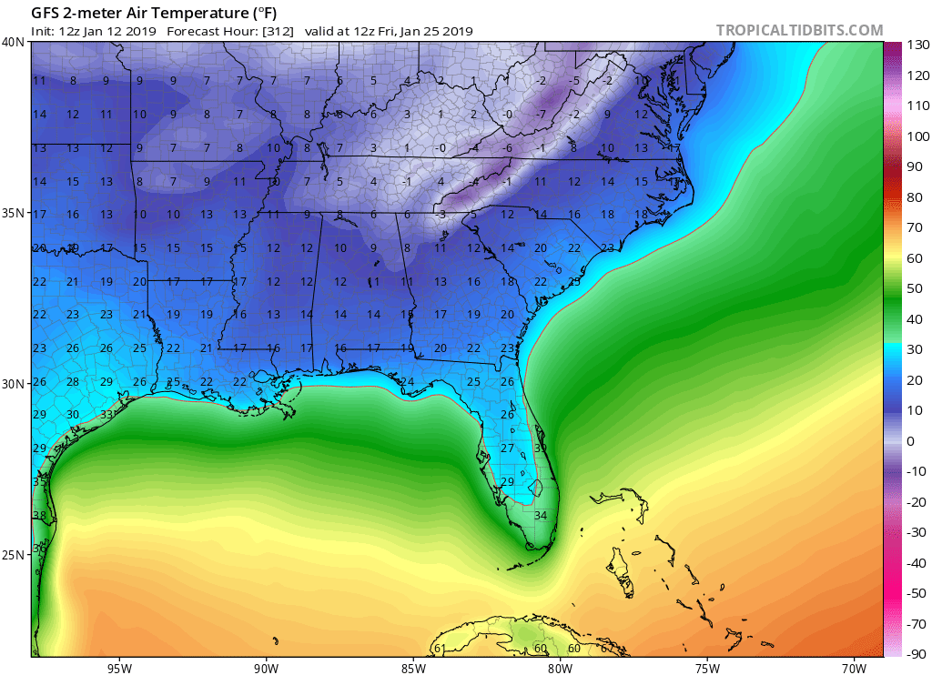
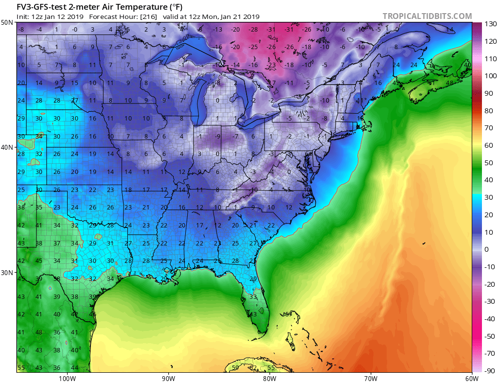
Posted: Sat Jan 12, 2019 1:21 pm
by gatorcane
psyclone wrote:As long as the cold remains on the 300 hour GFS while it's 75 out my door...I'm ok with it..
First round is showing up sooner that that at 216 hours:
Re: Florida Weather
Posted: Sat Jan 12, 2019 1:36 pm
by psyclone
This thread is littered with long range GFS predictions that are...(let me be diplomatic) not good. While it is possible that we eventually get cold...there is also a much less dramatic option on the table...which is we just have some chilly weather that averages out on the cool side of normal. mid to upper 60's is a below normal high temp regime for central florida...70 is below normal for south florida. I wouldn't be a buyer of any anomalous weather event until it starts appearing on the 7 day. otherwise there's just too many false alarms..
Re: Florida Weather
Posted: Sat Jan 12, 2019 1:42 pm
by gatorcane
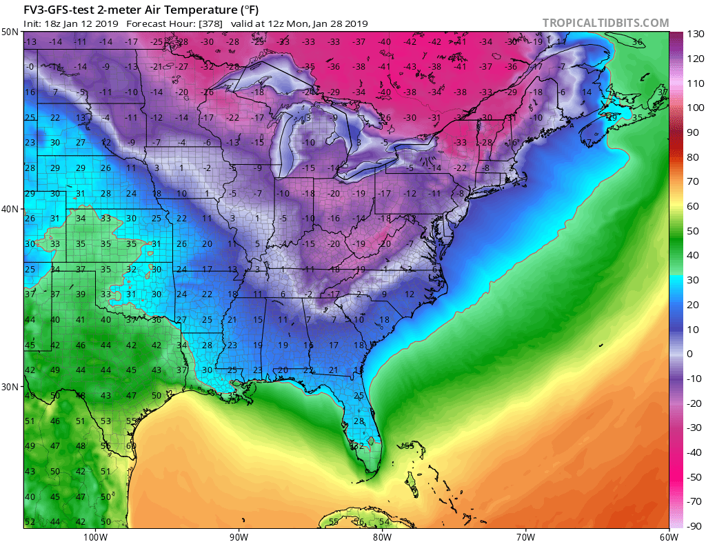
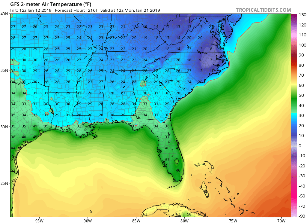
Yeah I agree about the long-range GFS and to proceed with caution. Just a few weeks ago it was calling for an arctic plunge for early to mid January and look how that turned out. It cooled down but nothing dramatic. This time though we are seeing many consecutive runs showing the cold if not getting colder. The 216 hour cold is backed up by several ECMWF runs. Let’s see if the 12Z has it.
Edit: 12Z ECMWF is also showing the 216 hour cold:
Re: Florida Weather
Posted: Sat Jan 12, 2019 1:55 pm
by psyclone
I am most definitely watching with interest. It is Winter and it should get cold at some point...and maybe we have a good freeze scare or actual freeze event. Florida's noteworthy weather history is big hurricanes (mostly in August through October) and freeze events (mostly December through February) so we're in the thick of a timeframe that history says...pay attention.
Re: Florida Weather
Posted: Sat Jan 12, 2019 2:06 pm
by northjaxpro
Let me say this. I know most in the industry deem the European model as old reliable. "The King" so to speak.
However, for as much as the GFS gets kicked around by some, l will be the first to tell you that the GFS has really improved in recent years.
I have become a bit more fonder of the GFS in my long range analysis and forecasting. Heck, the times I have gone out and stuck my neck out on this forum over the years, with success I may add, have been with sticking with the GFS solutions.
So, I am not one so caught up in model wars. I utilize EURO, GFS and UKMET primarily, and the NAM for winter weather and winter storm synoptics.
GFS is definitely getting better and the newer upgraded FV3. will hopefully give all of us better effeciency in analysis and forecasting.
Re: Florida Weather
Posted: Sat Jan 12, 2019 6:58 pm
by boca
The 18z GFS came in quite a bit warmer which I didn’t want but maybe just a hiccup,will see.
Re: Florida Weather
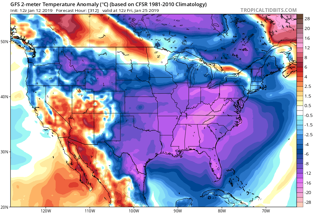
Posted: Sat Jan 12, 2019 8:37 pm
by gatorcane
Re: Florida Weather
Posted: Sat Jan 12, 2019 9:02 pm
by chaser1
Run after run model analysis is seriously reinforcing my consideration to actually break down and buy an ice scraper for my windshield

Re: Florida Weather
Posted: Sat Jan 12, 2019 9:10 pm
by boca
chaser1 wrote:Run after run model analysis is seriously reinforcing my consideration to actually break down and buy an ice scraper for my windshield
I’m going to need an ice scrapper going to New York on Jan 24th for a week that’s shows -8.
Re: Florida Weather
Posted: Sun Jan 13, 2019 12:07 am
by boca
00z GFS has also backed off on the cold.In the back of my mouth and I thought this was too good too be true.