C/S TX Weather: Seasonal with some rains
Moderator: S2k Moderators
Forum rules

The posts in this forum are NOT official forecast and should not be used as such. They are just the opinion of the poster and may or may not be backed by sound meteorological data. They are NOT endorsed by any professional institution or STORM2K.

-
Portastorm

- Storm2k Moderator

- Posts: 9787
- Age: 61
- Joined: Fri Jul 11, 2003 9:16 am
- Location: South Austin, TX
- Contact:
Re: C/SC TX Weather: Frying Pan Summer
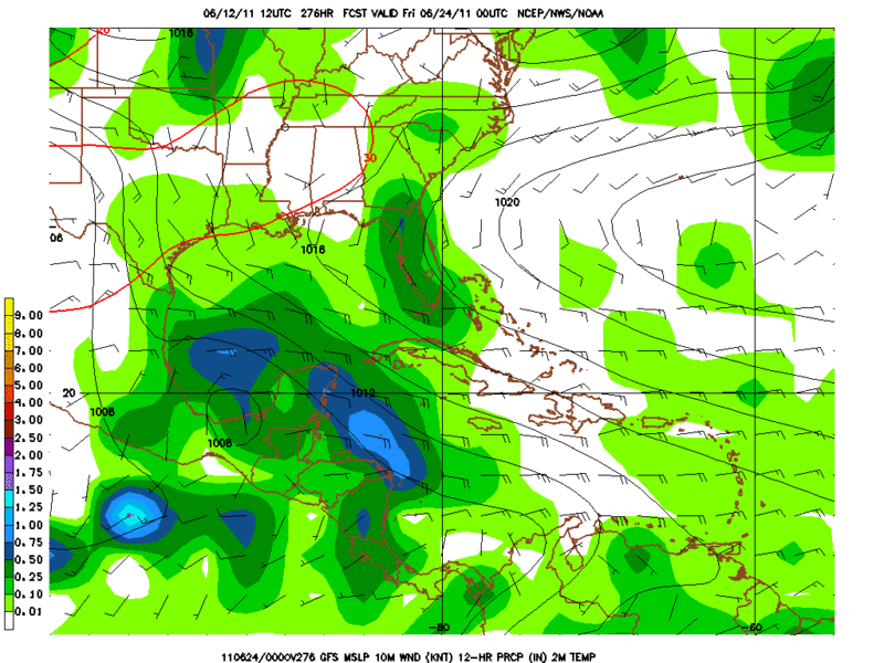
FWIW, the 0z GFS appears to show some rain in la-la land (like 276 hours out around June 22nd).
http://www.nco.ncep.noaa.gov/pmb/nwprod/analysis/namer/gfs/00/fp0_276.shtml
http://www.nco.ncep.noaa.gov/pmb/nwprod/analysis/namer/gfs/00/fp0_276.shtml
0 likes
Any forecasts under my name are to be taken with a grain of salt. Get your best forecasts from the National Weather Service and National Hurricane Center.
I'm a certified Advanced SKYWARN-trained spotter and am active on Twitter at @TravisCOSW, a social media partner of the NWS Austin-San Antonio office.
I'm a certified Advanced SKYWARN-trained spotter and am active on Twitter at @TravisCOSW, a social media partner of the NWS Austin-San Antonio office.
-
Rgv20

- S2K Supporter

- Posts: 2456
- Age: 37
- Joined: Wed Jan 05, 2011 5:42 pm
- Location: Edinburg/McAllen Tx
BTW its still showing that 500mb Low but now in the western gulf south of Brownsville.
0 likes
The following post is NOT an official forecast and should not be used as such. It is just the opinion of the poster and may or may not be backed by sound meteorological data. It is NOT endorsed by any professional institution including storm2k.org For Official Information please refer to the NHC and NWS products.
I don't think I'll hold my breath!
Surprisingly we aren't seeing the skunks we've had the past couple of years. I think it's so dry the grubs are not in our yard this year! I am happy about no skunks!
We are having a major mosquito outbreak tho and we have no water in our yard at all. No buckets, pots, nothing. They are concentrated around one of our downspouts but it's dry. Weird.
The field mice are out in force! Our neighbor had some in her garage - we've seen them in the back yard. Our dog has seen them too - as friendly as she is to skunks, bunnies and other creatures, her terrier blood shows when she goes after the mice.
I've been busy cutting back the ivy that insists on climbing everything even in this drought.
I'm concerned about fires - it's alarmingly dry out there. I feels drier than it did this time of year in 2009 and I am worried about the 4th of July since our idiot neighbors in the next street always find bottle rockets and other aerial fireworks to illegally set off. I have never called 911 on them but if they do it this year, I'm calling. Those rockets have landed in our yard before!
0 likes
-
Portastorm
- Storm2k Moderator
- Posts: 9787
- Age: 61
- Joined: Fri Jul 11, 2003 9:16 am
- Location: South Austin, TX
- Contact:
Re:
Shoshana wrote:I don't think I'll hold my breath!
Surprisingly we aren't seeing the skunks we've had the past couple of years. I think it's so dry the grubs are not in our yard this year! I am happy about no skunks!
We are having a major mosquito outbreak tho and we have no water in our yard at all. No buckets, pots, nothing. They are concentrated around one of our downspouts but it's dry. Weird.
The field mice are out in force! Our neighbor had some in her garage - we've seen them in the back yard. Our dog has seen them too - as friendly as she is to skunks, bunnies and other creatures, her terrier blood shows when she goes after the mice.
I've been busy cutting back the ivy that insists on climbing everything even in this drought.
I'm concerned about fires - it's alarmingly dry out there. I feels drier than it did this time of year in 2009 and I am worried about the 4th of July since our idiot neighbors in the next street always find bottle rockets and other aerial fireworks to illegally set off. I have never called 911 on them but if they do it this year, I'm calling. Those rockets have landed in our yard before!
Yeah, your neighbors better cool it this year ... literally. When the City of Austin cancels its annual fireworks show on the 4th due to drought concerns, everyone should realize this is not the year to be blowing off fireworks!
0 likes
Any forecasts under my name are to be taken with a grain of salt. Get your best forecasts from the National Weather Service and National Hurricane Center.
I'm a certified Advanced SKYWARN-trained spotter and am active on Twitter at @TravisCOSW, a social media partner of the NWS Austin-San Antonio office.
I'm a certified Advanced SKYWARN-trained spotter and am active on Twitter at @TravisCOSW, a social media partner of the NWS Austin-San Antonio office.
-
Portastorm
- Storm2k Moderator
- Posts: 9787
- Age: 61
- Joined: Fri Jul 11, 2003 9:16 am
- Location: South Austin, TX
- Contact:
Re: C/SC TX Weather: Frying Pan Summer
I wish I could say there was rain on the horizon for us ... but the Sunday 0z GFS says nada. 
The 0z Euro shows stout ridging for at least 168 hours.
The 0z Euro shows stout ridging for at least 168 hours.
0 likes
Any forecasts under my name are to be taken with a grain of salt. Get your best forecasts from the National Weather Service and National Hurricane Center.
I'm a certified Advanced SKYWARN-trained spotter and am active on Twitter at @TravisCOSW, a social media partner of the NWS Austin-San Antonio office.
I'm a certified Advanced SKYWARN-trained spotter and am active on Twitter at @TravisCOSW, a social media partner of the NWS Austin-San Antonio office.
-
Rgv20
- S2K Supporter
- Posts: 2456
- Age: 37
- Joined: Wed Jan 05, 2011 5:42 pm
- Location: Edinburg/McAllen Tx
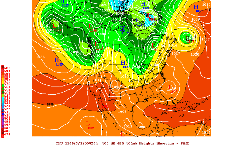
GFS continues to advertise a disturbance around late June in the Western Caribbean or Bay Of Campeche.
06-12-2011 12zGFS
0zECMWFENS by day 10 break down the ridge and that may allow whatever moisture that is in the BOC to creep up to Texas.

06-12-2011 12zGFS
0zECMWFENS by day 10 break down the ridge and that may allow whatever moisture that is in the BOC to creep up to Texas.
0 likes
The following post is NOT an official forecast and should not be used as such. It is just the opinion of the poster and may or may not be backed by sound meteorological data. It is NOT endorsed by any professional institution including storm2k.org For Official Information please refer to the NHC and NWS products.
-
~FlipFlopGirl~

- Tropical Depression

- Posts: 52
- Age: 45
- Joined: Sat Jul 24, 2010 7:43 pm
- Location: Waco,TX
Re: C/SC TX Weather: Frying Pan Summer
The 10 day outlook looks down right  hot- My job requires me to do home contacts each month - I am so bringing a cooler and changing the dress code up a bit- It's time to move this CAP over central tx- any disturbance is welcomed!!
hot- My job requires me to do home contacts each month - I am so bringing a cooler and changing the dress code up a bit- It's time to move this CAP over central tx- any disturbance is welcomed!!
0 likes
-
Portastorm
- Storm2k Moderator
- Posts: 9787
- Age: 61
- Joined: Fri Jul 11, 2003 9:16 am
- Location: South Austin, TX
- Contact:
Re: C/SC TX Weather: Frying Pan Summer
Well, we hit 100 degrees again yesterday (Sunday). I believe that is the 8th triple-digit day for us. On average, we get 14 triple-digit days. Problem is, we haven't even reached the official start to summer! 
The heat goes on ...
FWIW, the 0z GFS spins up something tropical in the Bay of Campeche late in its run.
Edit update: Hit triple digits at 3 p.m. at Camp Mabry today, so make that nine days now. And ... the 12z model runs still show more favorable conditions in the near tropics in about 12 days. Gonna be our only hope.
0 likes
Any forecasts under my name are to be taken with a grain of salt. Get your best forecasts from the National Weather Service and National Hurricane Center.
I'm a certified Advanced SKYWARN-trained spotter and am active on Twitter at @TravisCOSW, a social media partner of the NWS Austin-San Antonio office.
I'm a certified Advanced SKYWARN-trained spotter and am active on Twitter at @TravisCOSW, a social media partner of the NWS Austin-San Antonio office.
-
Rgv20
- S2K Supporter
- Posts: 2456
- Age: 37
- Joined: Wed Jan 05, 2011 5:42 pm
- Location: Edinburg/McAllen Tx
It hit 101 at my house today........on my way back to work my car read 109!!
In regards to rain we just have to wait and see what happens in the western Caribbean and BOC sometime in late June.
In regards to rain we just have to wait and see what happens in the western Caribbean and BOC sometime in late June.
0 likes
The following post is NOT an official forecast and should not be used as such. It is just the opinion of the poster and may or may not be backed by sound meteorological data. It is NOT endorsed by any professional institution including storm2k.org For Official Information please refer to the NHC and NWS products.
-
Rgv20
- S2K Supporter
- Posts: 2456
- Age: 37
- Joined: Wed Jan 05, 2011 5:42 pm
- Location: Edinburg/McAllen Tx
Official rainfall since October 2010 for the Rio Grande Valley.
Courtesy of the NWS in Brownsville.
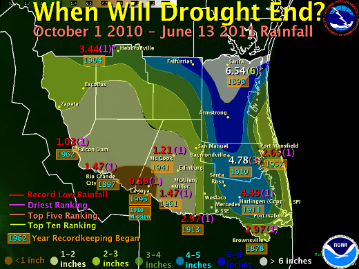
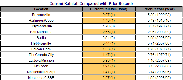
Link to the complete analysis..http://www.srh.noaa.gov/bro/?n=2011_midjunedroughtupdate
Courtesy of the NWS in Brownsville.
Link to the complete analysis..http://www.srh.noaa.gov/bro/?n=2011_midjunedroughtupdate
0 likes
The following post is NOT an official forecast and should not be used as such. It is just the opinion of the poster and may or may not be backed by sound meteorological data. It is NOT endorsed by any professional institution including storm2k.org For Official Information please refer to the NHC and NWS products.
-
Portastorm
- Storm2k Moderator
- Posts: 9787
- Age: 61
- Joined: Fri Jul 11, 2003 9:16 am
- Location: South Austin, TX
- Contact:
Re: C/SC TX Weather: Frying Pan Summer
Well, the 0z GFS and Euro both seem to breakdown the High Pressure Ridge of Death over Texas by the middle of next week. Let's keep our fingers crossed!
0 likes
Any forecasts under my name are to be taken with a grain of salt. Get your best forecasts from the National Weather Service and National Hurricane Center.
I'm a certified Advanced SKYWARN-trained spotter and am active on Twitter at @TravisCOSW, a social media partner of the NWS Austin-San Antonio office.
I'm a certified Advanced SKYWARN-trained spotter and am active on Twitter at @TravisCOSW, a social media partner of the NWS Austin-San Antonio office.
-
Tireman4

- S2K Supporter
- Posts: 5674
- Age: 58
- Joined: Fri Jun 30, 2006 1:08 pm
- Location: Humble, Texas
- Contact:
Re: C/SC TX Weather: Frying Pan Summer
Portastorm wrote:Well, the 0z GFS and Euro both seem to breakdown the High Pressure Ridge of Death over Texas by the middle of next week. Let's keep our fingers crossed!
We need a statement from the Portastorm Weather Center....what do they think?
0 likes
Re: C/SC TX Weather: Frying Pan Summer
Portastorm wrote:Well, the 0z GFS and Euro both seem to breakdown the High Pressure Ridge of Death over Texas by the middle of next week. Let's keep our fingers crossed!
Fingers AND toes crossed! Until then, the forecast is for dry, sunny and 100F.
I'll be dogsitting starting Tuesday - and it seems lately it only rains when I dogsit. Because yes, I do want to entertain 5 dogs while it's raining....
0 likes
LCRA's Bob Rose posted Monday re 2 week outlook
Forecast solutions indicate the ridge of high pressure will remain across Texas throughout the week and into the weekend, causing continued hot and dry weather. Late last week, some of the models indicated the ridge will split late this week, shifting to the west and the east. But today’s solutions indicate this likely won’t be the case. High temperatures throughout the week and into the weekend will be in the upper 90s to 100 degrees. Low temperatures will generally be in the low and middle 70s. Fortunately, breezy conditions will persist throughout the week thanks to a moderate pressure gradient. Expect a south wind with speeds of 10 to 15 mph.
Looking ahead to next week, today’s forecast solutions indicate the center of the ridge may temporarily shift to the east when a large trough of low pressure pushes east out of the Rockies. This shift could briefly help lower temperatures a couple of degrees and enable a few isolated showers to develop near the coast. But the ridge is forecast to build back across Texas by the middle of the week. So in general, I expect little change in the weather over the next ten-day to two-week period. The chance for rain is looking very low. High temperatures should stay in the upper 90s to 100 degrees. Today’s National Weather Service 8 to 14 day outlook for the period of June 21 through June 27 calls for well above normal temperatures and below normal precipitation. No big surprise here,
0 likes
103 at Mabry, 101 at Bergstrom.
Day 10 of 100F
Our gauge, which is in the sun this late in the day is reading 120.4F I had to do a double take because even tho it's in the sun every late afternoon I don't remember it hitting 120 before.
I forgot to look to see what the actual high was here (it doesn't record it but I usually remember to look at it during the day.
SO happy we got the a/c fixed last year!
0 likes
-
Rgv20
- S2K Supporter
- Posts: 2456
- Age: 37
- Joined: Wed Jan 05, 2011 5:42 pm
- Location: Edinburg/McAllen Tx
NWS Houston discussion regarding rain chances.
NWS Corpus discussion.
THE CHANCE
OF RAIN AND CORRESPONDING LOWER AFTERNOON HIGH TEMPERATURES MIGHT BE
COMING BY THE MIDDLE TO END OF NEXT WEEK AS MODELS INDICATE THE RIDGE
BREAKING DOWN AND SOME DEEPER TROPICAL MOISTURE POTENTIALLY SURGING
NORTH AND NORTHWEST TOWARD THE TEXAS COAST.
NWS Corpus discussion.
MODELS
CONTINUE TO HINT THE UPR TROUGH WILL WEAKEN THE RIDGE AND CAUSE IT
BREAK UP PUSHING PIECED TOWARD THE PACIFIC AND ATLANTIC NEXT WEEK.
THIS WOULD FINALLY OPEN THE DOOR TO A TROPICAL TAP JUST BEYOND THE
CURRENT FORECAST PERIOD AND GFS/ECMWF AND NAM ALL SHOW A WEEK WAVE
WITH DEEP MOISTURE POISED TO MOVE INTO THE WRN GULF. WILL NOT HOLD
MY BREATH JUST YET AS WE HAVE SEEN PROMISE OF PATTERN CHANGES IN
THE MODELS ONE TO TWO WEEKS OUT THAT HAVE NOT PANNED OUT...BUT WILL
CONTINUE TO MONITOR.
0 likes
The following post is NOT an official forecast and should not be used as such. It is just the opinion of the poster and may or may not be backed by sound meteorological data. It is NOT endorsed by any professional institution including storm2k.org For Official Information please refer to the NHC and NWS products.
-
Rgv20
- S2K Supporter
- Posts: 2456
- Age: 37
- Joined: Wed Jan 05, 2011 5:42 pm
- Location: Edinburg/McAllen Tx
Re: C/SC TX Weather: Frying Pan Summer
Portastorm wrote:Well, the 0z GFS and Euro both seem to breakdown the High Pressure Ridge of Death over Texas by the middle of next week. Let's keep our fingers crossed!
Still on schedule for next Thursday with a shot of rain or at the very least lower our temperatures a bit.
Whatever moisture there is in the BOC is going to have an opportunity to move NW to Texas.
0 likes
The following post is NOT an official forecast and should not be used as such. It is just the opinion of the poster and may or may not be backed by sound meteorological data. It is NOT endorsed by any professional institution including storm2k.org For Official Information please refer to the NHC and NWS products.
-
Portastorm
- Storm2k Moderator
- Posts: 9787
- Age: 61
- Joined: Fri Jul 11, 2003 9:16 am
- Location: South Austin, TX
- Contact:
Re: C/SC TX Weather: Frying Pan Summer
Yeppers ... the GFS and Euro continue to advertise the ridge over Texas breaking down in about a week. And yes the GFS for days now has shown significant moisture in the Western Gulf poised to move into the state. But until then ... it's the Frying Pan Summer 2011!
I'm thinking we may hit 105 today in Austin. It was several degrees warmer this morning at 8 am than the last few days.
I'm thinking we may hit 105 today in Austin. It was several degrees warmer this morning at 8 am than the last few days.
0 likes
Any forecasts under my name are to be taken with a grain of salt. Get your best forecasts from the National Weather Service and National Hurricane Center.
I'm a certified Advanced SKYWARN-trained spotter and am active on Twitter at @TravisCOSW, a social media partner of the NWS Austin-San Antonio office.
I'm a certified Advanced SKYWARN-trained spotter and am active on Twitter at @TravisCOSW, a social media partner of the NWS Austin-San Antonio office.
-
horselattitudesfarm

- Category 1

- Posts: 314
- Joined: Thu Jul 16, 2009 5:55 pm
- Location: Asheville, NC (formerly from Dallas, TX)
Re: C/SC TX Weather: Frying Pan Summer
Everyone who is concerned about Texas weather, the current situation, and what the future holds might want to check out the following website and check out the scientists credited there. I have written to a few of them and have had some interesting discussions.
http://texasdroughtproject.org/home.html
http://texasdroughtproject.org/home.html
0 likes
Return to “USA & Caribbean Weather”
Who is online
Users browsing this forum: Brent, ElectricStorm and 64 guests