C/S TX Weather: Seasonal with some rains

U.S. & Caribbean Weather Discussions and Severe Weather Events

Moderator: S2k Moderators

Forum rules

The posts in this forum are NOT official forecast and should not be used as such. They are just the opinion of the poster and may or may not be backed by sound meteorological data. They are NOT endorsed by any professional institution or STORM2K.

Help Support Storm2K
Message
Author
User avatar
Ptarmigan
Category 5
Category 5
Posts: 5272
Joined: Wed Aug 16, 2006 9:06 pm

Re: C/SC TX Weather: Frying Pan Summer

#561 Postby Ptarmigan » Wed Jun 15, 2011 10:26 am

Portastorm wrote:Yeppers ... the GFS and Euro continue to advertise the ridge over Texas breaking down in about a week. And yes the GFS for days now has shown significant moisture in the Western Gulf poised to move into the state. But until then ... it's the Frying Pan Summer 2011!

I'm thinking we may hit 105 today in Austin. It was several degrees warmer this morning at 8 am than the last few days.


Let's hope the Cockroach Ridge breaks down for good. :grrr:
0 likes   

Shoshana
Category 5
Category 5
Posts: 1409
Joined: Thu Sep 09, 2004 7:50 pm
Location: NE Austin

#562 Postby Shoshana » Wed Jun 15, 2011 1:10 pm

Williamson and Travis Counties are both banning the sale of all fireworks for the 4th July.
0 likes   

User avatar
Tireman4
S2K Supporter
S2K Supporter
Posts: 5674
Age: 58
Joined: Fri Jun 30, 2006 1:08 pm
Location: Humble, Texas
Contact:

#563 Postby Tireman4 » Wed Jun 15, 2011 1:25 pm

Harris County too:


Fireworks Restriction
On June 7th 2011, Harris County Commissioners Court approved a restriction on the sale and use of restricted fireworks (skyrockets with sticks and missiles with fins) due to drought conditions. This restriction is effective immediately and will continue as long as drought conditions exist in Harris County. Recent afternoon thunderstorms have had little effect on reducing the drought; the Keetch-Byram drought index (KBDI) has increased to over 700 in the past two days. It is currently at 708 on scale of 0-800. Under a local declaration of disaster by County Judge Ed Emmett, additional restrictions may apply if drought conditions do not improve. The Harris County Fire Marshal's Office will continue to monitor drought conditions and outdoor fire danger.


http://www.hcfmo.net/
0 likes   

User avatar
Tireman4
S2K Supporter
S2K Supporter
Posts: 5674
Age: 58
Joined: Fri Jun 30, 2006 1:08 pm
Location: Humble, Texas
Contact:

#564 Postby Tireman4 » Wed Jun 15, 2011 1:26 pm

I am afraid people will not care in my neck of the woods and shoot them off anyway.
0 likes   

Shoshana
Category 5
Category 5
Posts: 1409
Joined: Thu Sep 09, 2004 7:50 pm
Location: NE Austin

#565 Postby Shoshana » Wed Jun 15, 2011 4:07 pm

Our firework ban includes not only the usual ones like bottle rockets and other rockets- but ALL fireworks and sparklers. They even cancelled all the municipal fireworks shows.

I don't remember them doing that before.

103 Mabry, 100 Bergstrom Day 11 (eta highs today 104 Mabry, 102 Bergstrom)

Our house - 107.3F. I can see the grass drying up daily.

From the AAS

Travis and Williamson counties will go without fireworks this Independence Day.

Travis County Judge Sam Biscoe on Tuesday declared a local state of disaster, including a ban on the sale and use of fireworks. Williamson County Judge Dan A. Gattis on Tuesday also issued a disaster declaration banning the sale of fireworks in the county.

The Travis County fire marshal is not approving any permits for public fireworks shows. Austin and Pflugerville have canceled their scheduled displays. In a typical July Fourth season, fireworks can be legally sold in counties from June 24 to July 4. Under state law, the sale of fireworks is legal in counties but not inside city limits.

With the disaster declaration, county prohibitions on fireworks last 2½ days. Gov. Rick Perry has the authority to extend the fireworks ban. Perry has indicated he would grant an extension of Travis County's declaration until July 5, according to county staff. Williamson County has forwarded its declaration to Perry asking for an extension.

Williamson and Travis are among several counties in the state in the highest category of drought, exceptional. Travis County has been under a burn ban since Dec. 14.

If conditions change, Biscoe said commissioners may lift the disaster declaration and fireworks ban.
Last edited by Shoshana on Wed Jun 15, 2011 5:38 pm, edited 1 time in total.
0 likes   

User avatar
jasons2k
Storm2k Executive
Storm2k Executive
Posts: 8076
Age: 50
Joined: Wed Jul 06, 2005 12:32 pm
Location: The Woodlands, TX

Re:

#566 Postby jasons2k » Wed Jun 15, 2011 4:27 pm

Tireman4 wrote:Harris County too:


Fireworks Restriction
On June 7th 2011, Harris County Commissioners Court approved a restriction on the sale and use of restricted fireworks (skyrockets with sticks and missiles with fins) due to drought conditions. This restriction is effective immediately and will continue as long as drought conditions exist in Harris County. Recent afternoon thunderstorms have had little effect on reducing the drought; the Keetch-Byram drought index (KBDI) has increased to over 700 in the past two days. It is currently at 708 on scale of 0-800. Under a local declaration of disaster by County Judge Ed Emmett, additional restrictions may apply if drought conditions do not improve. The Harris County Fire Marshal's Office will continue to monitor drought conditions and outdoor fire danger.

http://www.hcfmo.net/


Just the aerials so far, which seems to happen almost every year now. I believe they meet again on the 17th to determine if it will include ALL fireworks. A buddy of mine owns a few stands and as an eternal optimist he says "I'm not worried about it; they'll pay them off with enough money to keep us open". I told him "Sorry, dude, I just don't think it's gonna happen this year..."
0 likes   

User avatar
Houstonia
S2K Supporter
S2K Supporter
Posts: 829
Age: 58
Joined: Fri Oct 11, 2002 9:45 am
Location: Sharpstown, Houston, Harris County, Southeast Texas.

Re: C/SC TX Weather: Frying Pan Summer

#567 Postby Houstonia » Wed Jun 15, 2011 5:49 pm

I can't believe I am crossing my fingers in hopes of even a 20 percent chance of rain...

http://forecast.weather.gov/product.php?site=NWS&issuedby=HGX&product=AFD&format=CI&version=1&glossary=1

AREA FORECAST DISCUSSION
NATIONAL WEATHER SERVICE HOUSTON/GALVESTON TX
156 PM CDT WED JUN 15 2011

MODELS ARE CONTINUING TO OFFER A PATTERN CHANGE NEXT WEEK WITH THE DEVELOPMENT
OF A BROAD CENTRAL U.S. TROUGH WHICH WOULD END UP LOWERING OUR ALMOST
DAILY NEAR RECORD HIGH TEMPERATURES AND BRINGING RAIN BACK INTO OUR
FORECAST. WILL START WITH 20% POPS BACK INTO OUR AREA TUESDAY AFTERNOON...BUT
IT IS POSSIBLE THAT MOISTURE LEVELS WILL STILL BE TOO LOW. 20% POPS
WEDNESDAY AND POSSIBLY EVEN HIGHER RAIN CHANCES DURING THE MIDDLE THROUGH
END OF NEXT WEEK SEEM POSSIBLE WITH THE TROUGH AS OUR MAJOR PLAYER
AND THE POTENTIAL INFLUX OF SOME DEEPER TROPICAL MOISTURE. CPC`S 8-14
DAY OUTLOOK ISSUED YESTERDAY ACTUALLY SHOWS SOME HOPE FOR OUR AREA WITH
TEMPERATURE PROBABILITIES NEAR NORMAL AND PRECIPITATION PROBABILITIES
EDGING SLIGHTLY ABOVE NORMAL. 42
0 likes   

User avatar
Tireman4
S2K Supporter
S2K Supporter
Posts: 5674
Age: 58
Joined: Fri Jun 30, 2006 1:08 pm
Location: Humble, Texas
Contact:

Re: Re:

#568 Postby Tireman4 » Wed Jun 15, 2011 7:11 pm

jasons wrote:
Tireman4 wrote:Harris County too:


Fireworks Restriction
On June 7th 2011, Harris County Commissioners Court approved a restriction on the sale and use of restricted fireworks (skyrockets with sticks and missiles with fins) due to drought conditions. This restriction is effective immediately and will continue as long as drought conditions exist in Harris County. Recent afternoon thunderstorms have had little effect on reducing the drought; the Keetch-Byram drought index (KBDI) has increased to over 700 in the past two days. It is currently at 708 on scale of 0-800. Under a local declaration of disaster by County Judge Ed Emmett, additional restrictions may apply if drought conditions do not improve. The Harris County Fire Marshal's Office will continue to monitor drought conditions and outdoor fire danger.

http://www.hcfmo.net/


Just the aerials so far, which seems to happen almost every year now. I believe they meet again on the 17th to determine if it will include ALL fireworks. A buddy of mine owns a few stands and as an eternal optimist he says "I'm not worried about it; they'll pay them off with enough money to keep us open". I told him "Sorry, dude, I just don't think it's gonna happen this year..."


I agree Jason. It is just to volatile out there.
0 likes   

User avatar
~FlipFlopGirl~
Tropical Depression
Tropical Depression
Posts: 52
Age: 45
Joined: Sat Jul 24, 2010 7:43 pm
Location: Waco,TX

#569 Postby ~FlipFlopGirl~ » Wed Jun 15, 2011 9:54 pm

McLennan County has a 60% chance on Wed- But I am not holding my breath- 4 days in a row of triple digits :(
0 likes   

User avatar
Rgv20
S2K Supporter
S2K Supporter
Posts: 2456
Age: 37
Joined: Wed Jan 05, 2011 5:42 pm
Location: Edinburg/McAllen Tx

#570 Postby Rgv20 » Thu Jun 16, 2011 12:06 am

Forecast for the next five days for my area High 102 Low 79 :sun:


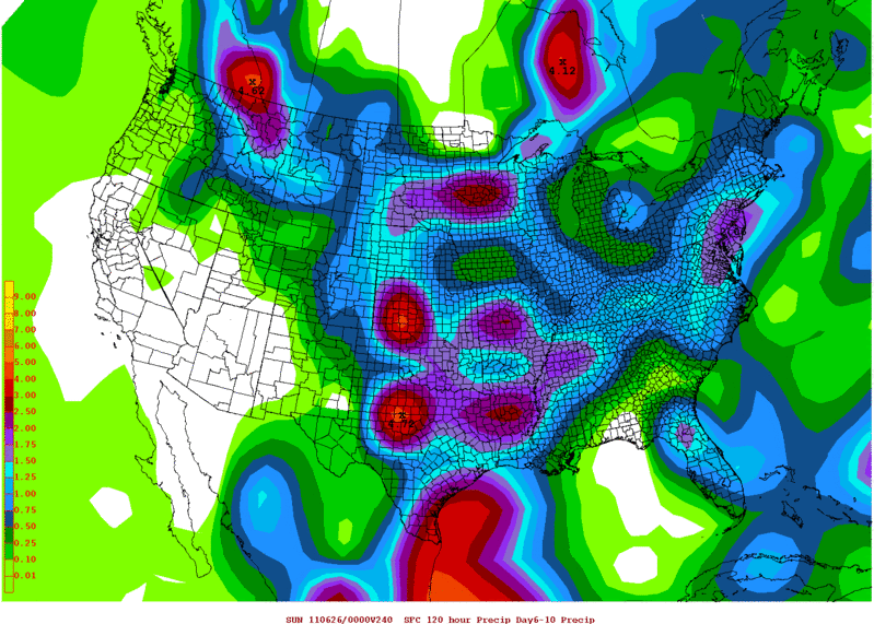
Still some hope via the 0zGFS for late next week...........Almost the whole state of Texas with some beneficial rains from about Tuesday to Saturday.

Image

Also the 12zECMWF prints out rain for most of Texas on that same time period as the map above and both the ECMWF and GFS forecast Precipitable Water to be at 2+ inches!! for most of South Texas.
0 likes   
The following post is NOT an official forecast and should not be used as such. It is just the opinion of the poster and may or may not be backed by sound meteorological data. It is NOT endorsed by any professional institution including storm2k.org For Official Information please refer to the NHC and NWS products.

Shoshana
Category 5
Category 5
Posts: 1409
Joined: Thu Sep 09, 2004 7:50 pm
Location: NE Austin

#571 Postby Shoshana » Thu Jun 16, 2011 12:10 am

Both Bastrop and Hays Counties now have a total fireworks ban.

Still in the 80's at midnight.
0 likes   

Shoshana
Category 5
Category 5
Posts: 1409
Joined: Thu Sep 09, 2004 7:50 pm
Location: NE Austin

Re: C/SC TX Weather: Frying Pan Summer

#572 Postby Shoshana » Thu Jun 16, 2011 11:57 am

Drought could dry Llano River by week's end, officials say

The Llano River is Llano's main source of drinking water and they're saying that the 2 backup reservoirs may be unsuitable for water treatment. So they're thinking about trucking in water and digging wells... seems to me they should have done something before now...

I kinda surprised Austin is still in Stage 1 water restrictions. I know the lakes are dropping but I guess they haven't hit the point where everyone starts to panic.

Image
0 likes   

User avatar
Portastorm
Storm2k Moderator
Storm2k Moderator
Posts: 9787
Age: 61
Joined: Fri Jul 11, 2003 9:16 am
Location: South Austin, TX
Contact:

Re: C/SC TX Weather: Frying Pan Summer

#573 Postby Portastorm » Thu Jun 16, 2011 4:01 pm

Unfortunately there is now a large brushfire burning in Leander, just northwest of town. 200 homes have been evacuated.

http://www.statesman.com/blogs/content/shared-gen/blogs/austin/blotter/entries/2011/06/16/brush_fire_forces_evacuation.html
0 likes   
Any forecasts under my name are to be taken with a grain of salt. Get your best forecasts from the National Weather Service and National Hurricane Center.

I'm a certified Advanced SKYWARN-trained spotter and am active on Twitter at @TravisCOSW, a social media partner of the NWS Austin-San Antonio office.

User avatar
Rgv20
S2K Supporter
S2K Supporter
Posts: 2456
Age: 37
Joined: Wed Jan 05, 2011 5:42 pm
Location: Edinburg/McAllen Tx

#574 Postby Rgv20 » Thu Jun 16, 2011 4:31 pm

Corpus afternoon discussion

BY MID WEEK THE UPR TROUGH BREAKS THE HIGH INTO TWO PIECES...ONE
ACROSS THE ATL AND ONE IN THE PAC AND THIS LEAVES A WEAKNESS ACROSS
TEXAS. MEANWHILE...A WEAK TROPICAL WAVE CURRENTLY ACROSS THE ERN
CARIBBEAN SEA AND ASSOC BLOB OF DEEP TROPICAL MOISTURE (PWS SHOWN BY
GFS > 2.5 INCHES) IS FORECAST TO MOVE INTO THE BAY OF CAMPECHE EARLY
NEXT WEEK. THIS IS WHERE GFS AND ECMWF DIVERGE SOMEWHAT. THE LAST
FEW RUNS OF THE ECMWF SHOW A WEAKER WAVE BUT STRONGER ATLANTIC
TROUGH AND THEREFORE MOVES THE WAVE AND DEEPEST MOISTURE FASTER
ACROSS THE AREA W/ THU BEING THE BEST DAY FOR PRECIP. THE GFS IS
WEAKER W/ THE ATL RIDGE AND IS VERY SLOW TO MOVE THE SYSTEM NORTH
AND THE BEST PRECIP DAYS APPEAR LATER IN THE PERIOD TOWARD THE
WEEKEND. THE GFS ALSO SHOWS A STRONGER SYSTEM BORDERING ON BECOMING
A DEPRESSION AND IT EVENTUALLY TAKES IT MORE NRLY W/ HIGHEST
MOISTURE MVG INTO SE TEXAS OVER THE WEEKEND ALTHOUGH IT STILL SHOWS
SOME DECENT RAINFALL POTENTIAL ACROSS THE ERN CWA. REALLY IS WAY TO
EARLY TO TELL AND MODELS (ESP GFS) HAVE NOT BEEN VERY CONSISTENT
REGARDING THE DETAILS WHICH IS NOT SURPRISING BEING NEARLY A WEEK
OUT. THERE IS ENOUGH CONSISTENCY FOR THE LAST 3 DAYS HOWEVER TO
BEGIN TO INTRODUCE POPS AS THE RISK OF JINXING IT FOR DROUGHT
STRICKEN S TX. GFS AND ECMWF BOTH SHOW ENOUGH MOISTURE OUT AHEAD OF
THE MAIN TROUGH TO INCLUDE 10-20 POPS FOR TUE AND WILL SHOW THEM
INCREASING TO 10-30 WED AND THU W/ HIGHEST POPS ACROSS THE ERN HALF
FOR NOW REALIZING THIS COULD EASILY GO UP IF FASTER TIMING PANS OUT
AND HIGHS WHICH ARE TRENDED DOWN COULD ALSO BE STILL TOO HIGH. HAVE
PLENTY OF TIME WATCH THIS DURING THE NEXT WEEK AND WILL KEEP OUR
FINGERS CROSSED.


Brownsville afternoon discussion.

.LONG TERM /SATURDAY THROUGH THURSDAY/...NOT GOING TO DWELL ON THE
FIRST TWO THIRDS OF THE LONG TERM WITH THE PERSISTENT
HEAT...HUMIDITY AND WIND TO PERSIST. BROAD HIGH PRESSURE TO WEAKEN
JUST A TAD OR THE CENTER OF THE 50H RIDGE GETS PUSHED SOUTHEAST AS
STRONGER THEN NORMAL MID LEVEL TROUGH MOVES INTO THE ROCKIES THIS
WEEKEND. THIS WILL RESULT IN MUCH OF THE SAME WITH ABOVE NORMAL
TEMPERATURES FOR BOTH MINIMUMS AND MAXIMUMS. ANOMALIES HAVE BEEN
RUNNING 5 TO 10 DEGREES ABOVE WHAT IS EXPECTED FOR MID JUNE AND
THIS SHOULD CONTINUE. SOUTHERLY FLOW IS GETTING DEEPEN AND
STRONGER WITH LOW PRESSURE BECOMING DEEPER ACROSS THE SOUTHERN AND
CENTRAL PLAINS AS A RESULT OF THE APPROACHING UPPER TROUGH.
HUMIDITY LEVELS NOT EXPECTED TO VARY MUCH OR INCH UPWARD THROUGH
THE PERIOD WITH SEA SURFACE TEMPERATURES CONTINUING TO CLIMB AND
THE FETCH OF WINDS THAT ARE BEING TRANSPORTED NORTH ACROSS THE
GULF AND INTO DEEP SOUTH TEXAS. WITH THIS SAID SOME OF THE MODELS
HAVE BEEN INDICATING A MUCH DEEPER FETCH OF TROPICAL MOISTURE
WORKING ITS WAY NORTHWARD INTO THE BAY OF CAMPECHE AND POSSIBLY
INTO THE WESTERN GULF OF MEXICO. PLENTY OF MOISTURE OVER THE
EASTERN PACIFIC ALONG THE NORTHERN EXTENT OF THE ITCZ COULD GET
PULLED NORTHWARD AS THE SUBTROPICAL RIDGE CENTERS ITSELF OVER THE
EASTERN GULF AND THE UPPER RIDGE LIFTS NORTH INTO THE CENTRAL
PLAINS BY THE MIDDLE OF NEXT WEEK. THIS COULD OPEN THE DOOR FOR AN
INCREASE OF RAIN CHANCES ANYWHERE FROM THE WESTERN GULF...THE RIO
GRANDE VALLEY AND AS FAR NORTH AS THE NORTHERN GULF STATES.
UNCERTAINTY RESIDES WITH THE EARLIEST OCCURRENCE OF CONVECTION
FORMATION IN THE FORM OF STREAMER SHOWERS TUESDAY NIGHT THEN
SPREADING NORTH WEDNESDAY AND THURSDAY. AT THIS TIME WILL JUST
ADD SILENT 10 POPS AND CONTINUE TO MONITOR THE SITUATION OVER THE
WEEKEND. WITH DEEP SOUTH TEXAS IN THIS LONG TERM DROUGHT WILL
CONTINUE TO LIVE BY THE SAYING WHEN IN DOUBT LEAVE IT OUT. HOWEVER
WE WILL CONTINUE TO POSITIVELY...THINK...RAIN.
0 likes   
The following post is NOT an official forecast and should not be used as such. It is just the opinion of the poster and may or may not be backed by sound meteorological data. It is NOT endorsed by any professional institution including storm2k.org For Official Information please refer to the NHC and NWS products.

Shoshana
Category 5
Category 5
Posts: 1409
Joined: Thu Sep 09, 2004 7:50 pm
Location: NE Austin

#575 Postby Shoshana » Thu Jun 16, 2011 4:47 pm

Day 12 but the Austin area might get a break next week....
0 likes   

User avatar
vbhoutex
Storm2k Executive
Storm2k Executive
Posts: 28974
Age: 72
Joined: Wed Oct 09, 2002 11:31 pm
Location: Spring Branch area, Houston, TX
Contact:

Re:

#576 Postby vbhoutex » Thu Jun 16, 2011 8:05 pm

Shoshana wrote:Day 12 but the Austin area might get a break next week....

Is that day 12 of official triple digit temps or day 12 of triple digits at your house? I know any way you paint it it is HOT!
0 likes   
Skywarn, C.E.R.T.
Please click below to donate to STORM2K to help with the expenses of keeping the site going:
Image

Shoshana
Category 5
Category 5
Posts: 1409
Joined: Thu Sep 09, 2004 7:50 pm
Location: NE Austin

#577 Postby Shoshana » Thu Jun 16, 2011 9:39 pm

Day 12 of 100+ officially. Not keepin track of 100+ at the house!

What is crazy is that we avg 12 in a summer - and it's not even summer yet!
0 likes   

User avatar
vbhoutex
Storm2k Executive
Storm2k Executive
Posts: 28974
Age: 72
Joined: Wed Oct 09, 2002 11:31 pm
Location: Spring Branch area, Houston, TX
Contact:

Re:

#578 Postby vbhoutex » Thu Jun 16, 2011 9:59 pm

Shoshana wrote:Day 12 of 100+ officially. Not keepin track of 100+ at the house!

What is crazy is that we avg 12 in a summer - and it's not even summer yet!

Just like Houston except we average 5 in a summer iirc and as you said it isn't even summer yet. I think our official is 6 now for June.
0 likes   
Skywarn, C.E.R.T.
Please click below to donate to STORM2K to help with the expenses of keeping the site going:
Image

Shoshana
Category 5
Category 5
Posts: 1409
Joined: Thu Sep 09, 2004 7:50 pm
Location: NE Austin

#579 Postby Shoshana » Thu Jun 16, 2011 11:48 pm

eep!!!! So is it any drier than normal in Houston? Cause the humidity is usually brutal!

I just saw the 7 day forecast from KXAN

Friday 104*
Sat 105*
Sun 105*
Mon 103
Tues 101 (10% chance of isolated tstorms)
Wed 99 (20% chance of isolated tstorms)

*record for day

What's unnerving is that I have heard several forecasters talking about 2009's 68 days of 100+ and the all time record of 69 days... (gulp)
0 likes   

User avatar
vbhoutex
Storm2k Executive
Storm2k Executive
Posts: 28974
Age: 72
Joined: Wed Oct 09, 2002 11:31 pm
Location: Spring Branch area, Houston, TX
Contact:

Re:

#580 Postby vbhoutex » Fri Jun 17, 2011 12:27 am

Shoshana wrote:eep!!!! So is it any drier than normal in Houston? Cause the humidity is usually brutal!

I just saw the 7 day forecast from KXAN

Friday 104*
Sat 105*
Sun 105*
Mon 103
Tues 101 (10% chance of isolated tstorms)
Wed 99 (20% chance of isolated tstorms)

*record for day

What's unnerving is that I have heard several forecasters talking about 2009's 68 days of 100+ and the all time record of 69 days... (gulp)

Fortunately it has been(operative word is has)drier than normal, however the humidity is expected to go up from here so they are contemplating having to put out heat advisories over the weekend(feels like >108f). Our 5 day is about 4 degrees below yours with about the same rain percentages, but with the increased humidity it could get really miserable. Some of our local OCMs have been talking about this rivaling our longest run of 100+ temps and/or breaking our all time high of 109F. :roll: I sure hope they are wrong. When it hit 109F officially here it was 112F at my house and the AC wouldn't cool the house below 82F(and it was working fine-We have added insulation since then). Is it Winter yet?
0 likes   
Skywarn, C.E.R.T.
Please click below to donate to STORM2K to help with the expenses of keeping the site going:
Image


Return to “USA & Caribbean Weather”

Who is online

Users browsing this forum: dfw_toadie, rwfromkansas and 147 guests