Wave E of the Leewards
Moderator: S2k Moderators
Forum rules

The posts in this forum are NOT official forecasts and should not be used as such. They are just the opinion of the poster and may or may not be backed by sound meteorological data. They are NOT endorsed by any professional institution or STORM2K. For official information, please refer to products from the National Hurricane Center and National Weather Service.

Re: Interesting developments E of the Leewards
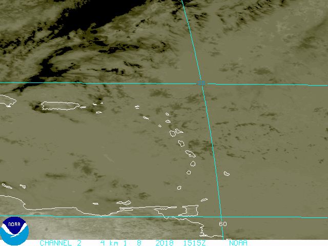
If the convection persists today look for this to become 91L. Of all the systems so far this year, this one and the synoptic setup could be the biggest threat to the greater antilles, Bahamas, and SE US. It will tuck itself under the ridge in the western Atlantic and generally move W-NW from this point over the next 4-5 days.
0 likes


Man Gusty i didn't know this wave had a low.  exciting!
So right now is the wave moving west? or westnorth west? i need to know. now that it looks better i think its time for us to start guessing, when it will be declared an invest. i think maybe later today, tomorrow,
or tuesday. i have to say if it can keep most of its convection it would be an invest today, but i would have to go with tomorrow.
0 likes
-
HURAKAN

- Professional-Met

- Posts: 46084
- Age: 39
- Joined: Thu May 20, 2004 4:34 pm
- Location: Key West, FL
- Contact:
Re: Interesting developments E of the Leewards
ronjon wrote:If the convection persists today look for this to become 91L. Of all the systems so far this year, this one and the synoptic setup could be the biggest threat to the greater antilles, Bahamas, and SE US. It will tuck itself under the ridge in the western Atlantic and generally move W-NW from this point over the next 4-5 days.
Or 92L because the system SW of the CV Islands already has the floater over it but has not been called an invest. I believe that your analysis is true and that's why it's very important to keep an eye on it. Yesterday we talked about persistance and the system has persisted already ~24 hrs. Surely something that has to be watched.
0 likes
-
Gustywind

- Category 5

- Posts: 12334
- Joined: Mon Sep 03, 2007 7:29 am
- Location: Baie-Mahault, GUADELOUPE
Latest sat pic from Meteo-France 8am, looking nice :
http://www.meteo.fr/temps/domtom/antill ... Tagant.jpg
http://www.meteo.fr/temps/domtom/antill ... Tagant.jpg
0 likes
-
Gustywind
- Category 5
- Posts: 12334
- Joined: Mon Sep 03, 2007 7:29 am
- Location: Baie-Mahault, GUADELOUPE
ronjon wrote:
If the convection persists today look for this to become 91L. Of all the systems so far this year, this one and the synoptic setup could be the biggest threat to the greater antilles, Bahamas, and SE US. It will tuck itself under the ridge in the western Atlantic and generally move W-NW from this point over the next 4-5 days.
Hurakan wrote:
Or 92L because the system SW of the CV Islands already has the floater over it but has not been called an invest. I believe that your analysis is true and that's why it's very important to keep an eye on it. Yesterday we talked about persistance and the system has persisted already ~24 hrs. Surely something that has to be watched.
Absolutely good analysis,persitence seems once more time the KEY FACTOR, but maybe a player for the next couple of days if if if it this trend continues....
0 likes
-
Gustywind
- Category 5
- Posts: 12334
- Joined: Mon Sep 03, 2007 7:29 am
- Location: Baie-Mahault, GUADELOUPE
PUNKYG wrote:
Man Gusty i didn't know this wave had a low. exciting!
So right now is the wave moving west? or westnorth west? i need to know. now that it looks better i think its time for us to start guessing, when it will be declared an invest. i think maybe later today, tomorrow,
or tuesday. i have to say if it can keep most of its convection it would be an invest today, but i would have to go with tomorrow.
Yeah punky you have well resumed the synopsis, i'm agree with in all points of view ,i will say invest for tommorow. Seems that next week is open for buisness we could have 2 invests in the same as things are shaping up! 
Man Gusty i didn't know this wave had a low. exciting!
So right now is the wave moving west? or westnorth west? i need to know. now that it looks better i think its time for us to start guessing, when it will be declared an invest. i think maybe later today, tomorrow,
or tuesday. i have to say if it can keep most of its convection it would be an invest today, but i would have to go with tomorrow.
Yeah punky you have well resumed the synopsis, i'm agree with in all points of view ,i will say invest for tommorow. Seems that next week is open for buisness we could have 2 invests in the same as things are shaping up!
0 likes

Re: Interesting developments E of the Leewards
Vortex,
Good call on this wave/low.
Looks like development is possible and could be a threat to Fla & GOM next weekend.
The tropics are heating up, the next 6-8 weeks could be very active.
Good call on this wave/low.
Looks like development is possible and could be a threat to Fla & GOM next weekend.
The tropics are heating up, the next 6-8 weeks could be very active.
0 likes


Re: Interesting developments E of the Leewards
Will thet trough infuence the track of this wave.
0 likes


Re: Interesting developments E of the Leewards
Looks like the trough is pulling it north somewhat around 25n.
0 likes
-
HURAKAN
- Professional-Met
- Posts: 46084
- Age: 39
- Joined: Thu May 20, 2004 4:34 pm
- Location: Key West, FL
- Contact:
Re: Interesting developments E of the Leewards
cycloneye wrote:Hmmm,Do I see some fanning of the clouds?
¡Esto se está cocinando!
This is cooking!
0 likes
Re: Interesting developments E of the Leewards
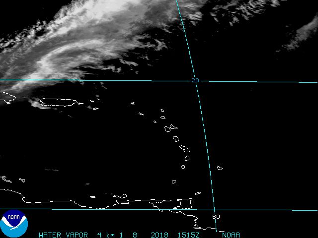
It does have a disturbed look. No surface activity yet, but that will probably follow. Where does it go?
0 likes

Re: Interesting developments E of the Leewards
The GFS, NOGAPS, and NAM strengthen the ridge to the North and take this wave/low across the Leewards/PR and towards the Bahamas and florida over the next 3-5 days..This forecast seems reasonable given the synoptics in play...Also the consistency of the GFS for days on the track has not changed.
Note:As this system moves w/wnw and gets away from the influence of the trough to the north we should expect a continued increase in overall organization and a favorable upper-air pattern beginning Monday..
Note:As this system moves w/wnw and gets away from the influence of the trough to the north we should expect a continued increase in overall organization and a favorable upper-air pattern beginning Monday..
0 likes
-
wzrgirl1

- S2K Supporter

- Posts: 1360
- Joined: Sat Sep 04, 2004 6:44 am
- Location: Pembroke Pines, Florida
Re: Interesting developments E of the Leewards
Vortex wrote:The GFS, NOGAPS, and NAM strengthen the ridge to the North and take this wave/low across the Leewards/PR and towards the Bahamas and florida over the next 3-5 days..This forecast seems reasonable given the synoptics in play...Also the consistency of the GFS for days on the track has not changed.
Note:As this system moves w/wnw and gets away from the influence of the trough to the north we should expect a continued increase in overall organization and a favorable upper-air pattern beginning Monday..
Hey Vortex,
Can u post the links to those models you speak of. Thanks!!
0 likes
Hi-Res Vis this morning indicating a MLC/LLC forming near 17N/57.5W....
There is also the Low noted in the TWD near 14N/57W..
Both are becoming clearly evident on Vis this morning...It will be interesting to follow which one takes over...
Either way looks like an active period of weather for the Leewards west to PR beginning tonight through Monday night...
There is also the Low noted in the TWD near 14N/57W..
Both are becoming clearly evident on Vis this morning...It will be interesting to follow which one takes over...
Either way looks like an active period of weather for the Leewards west to PR beginning tonight through Monday night...
0 likes

Re:
Vortex wrote:Hi-Res Vis this morning indicating a MLC/LLC forming near 17N/57.5W....
There is also the Low noted in the TWD near 14N/57W..
Both are becoming clearly evident on Vis this morning...It will be interesting to follow which one takes over...
Either way looks like an active period of weather for the Leewards west to PR beginning tonight through Monday night...
I think your right....it does look like a MLC or LLC has formed. You san start to see some outflow..
http://www.ssd.noaa.gov/goes/east/carb/loop-vis.html
http://cimss.ssec.wisc.edu/tropic/real- ... g8dvg.html
good upper level divergence and some low level convergence....shear is not to bad. This one could get interestig for FL people. GFS show a weakness riding up into the BA and into FL but does not close off the low.
0 likes
-
storms in NC

- S2K Supporter
- Posts: 2338
- Joined: Thu Jul 28, 2005 2:58 pm
- Location: Wallace,NC 40 miles NE of Wilm
- Contact:
Who is online
Users browsing this forum: No registered users and 144 guests