ENSO Updates (2007 thru 2023)

This is the general tropical discussion area. Anyone can take their shot at predicting a storms path.

Moderator: S2k Moderators

Forum rules

The posts in this forum are NOT official forecasts and should not be used as such. They are just the opinion of the poster and may or may not be backed by sound meteorological data. They are NOT endorsed by any professional institution or STORM2K. For official information, please refer to products from the National Hurricane Center and National Weather Service.

Help Support Storm2K
Message
Author
User avatar
cycloneye
Admin
Admin
Posts: 139602
Age: 67
Joined: Thu Oct 10, 2002 10:54 am
Location: San Juan, Puerto Rico

Re: ENSO Updates=Models forecast Neutral by early summer

#1081 Postby cycloneye » Thu Feb 04, 2010 11:36 am

Here are two graphics,one from December 21 when El Nino was at its peak compared to Febuary 4.There is a marked difference as the december graphic shows plenty of reds while the Febuary 4 one has a small pocket.

December 21

Image


Febuary 4

Image

http://www.osdpd.noaa.gov/ml/ocean/sst/anomaly.html
0 likes   
Visit the Caribbean-Central America Weather Thread where you can find at first post web cams,radars
and observations from Caribbean basin members Click Here

User avatar
somethingfunny
ChatStaff
ChatStaff
Posts: 3926
Age: 35
Joined: Thu May 31, 2007 10:30 pm
Location: McKinney, Texas

Re: ENSO Updates=Models forecast Neutral by early summer

#1082 Postby somethingfunny » Thu Feb 04, 2010 3:45 pm

I see a large area of blue swelling up off of Chile. Just a hunch, but I think the models aren't telling the whole story when they forecast Neutral by early Summer. I think we'll have a full-fledged La Nina going by the end of Summer.

NOT A PROFESSIONAL FORECAST.
0 likes   

User avatar
cycloneye
Admin
Admin
Posts: 139602
Age: 67
Joined: Thu Oct 10, 2002 10:54 am
Location: San Juan, Puerto Rico

Re: ENSO Updates=Models forecast Neutral by early summer

#1083 Postby cycloneye » Fri Feb 05, 2010 7:12 am

BigA wrote:
xironman wrote:Thirty day average of SOI has dropped 14 points in 10 days

Code: Select all

26-Jan-2010 1010.00 1006.05 -3.10 -3.69 -7.42
27-Jan-2010 1008.15 1005.55 -9.46 -4.51 -7.30
28-Jan-2010 1006.18 1005.25 -17.33 -5.59 -7.41
29-Jan-2010 1006.51 1004.25 -11.06 -6.03 -7.40
30-Jan-2010 1005.41 1004.75 -18.60 -7.11 -7.43
31-Jan-2010 1001.99 1006.40 -42.49 -8.90 -7.71
1-Feb-2010 999.10 1006.45 -58.07 -11.14 -8.23
2-Feb-2010 999.15 1005.55 -53.51 -13.07 -8.76
3-Feb-2010 1001.71 1006.15 -44.09 -15.01 -9.27
4-Feb-2010 1000.54 1008.35 -60.28 -17.41 -10.08


I think a lot of this drop can be attributed to the fact that a strong tropical cyclone (Oli) has moved within a couple hundred miles of Tahiti.


Look at the 30 day SOI index how has crashed thanks to that powerful cyclone named Oli.

Image

Daily SOI Index

http://www.longpaddock.qld.gov.au/Seaso ... SOIValues/
0 likes   
Visit the Caribbean-Central America Weather Thread where you can find at first post web cams,radars
and observations from Caribbean basin members Click Here

User avatar
Macrocane
Category 5
Category 5
Posts: 4218
Age: 35
Joined: Sun May 24, 2009 5:35 pm
Location: El Salvador

Re: ENSO Updates=Models forecast Neutral by early summer

#1084 Postby Macrocane » Fri Feb 05, 2010 12:11 pm

I think that the february CPC discussion hasn't been posted yet, so here it is:

Synopsis: El Niño is expected to continue at least into the Northern Hemisphere spring 2010.

A significant El Niño persisted throughout the equatorial Pacific Ocean during January 2010 (Fig. 1). Although sea surface temperature (SST) departures in the Niño-3.4 region decreased to +1.2oC in late January, SSTs continued to be sufficiently warm to support deep tropical convection (Fig. 2 and Fig. 3). Over the last several months, a series of oceanic Kelvin waves contributed to the build-up of heat content anomalies in the central and eastern Pacific (Fig. 4). The latest Kelvin wave was associated with temperature departures exceeding +2oC down to 150m depth across the eastern half of the equatorial Pacific (Fig. 5). Equatorial convection over the central Pacific remained enhanced during the month, while convection over Indonesia exhibited considerable week-to-week variability. While the low-level winds have been variable, low-level westerly and upper-level easterly wind anomalies generally prevailed during January. Collectively, these oceanic and atmospheric anomalies reflect a strong and mature El Niño episode.

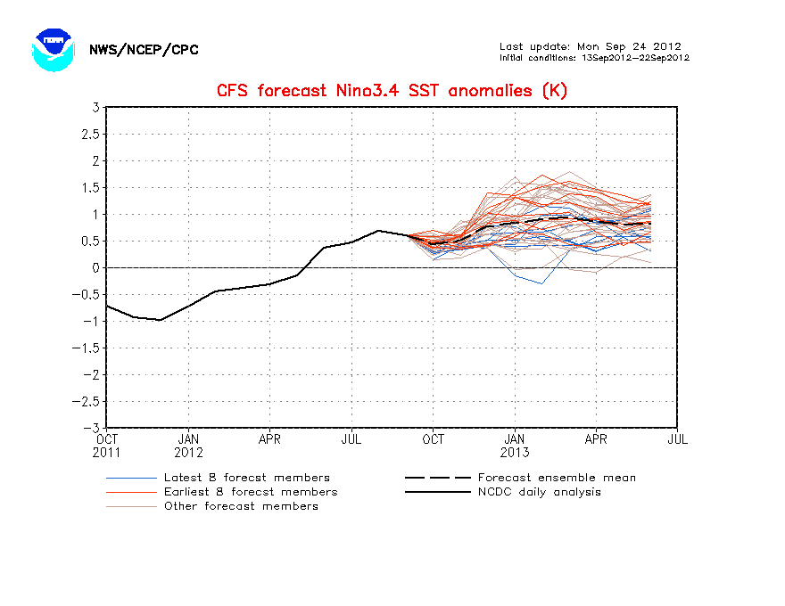
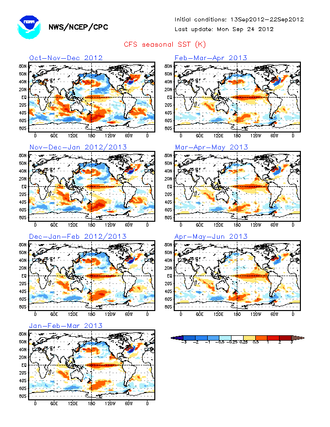
Nearly all models predict decreasing SST anomalies in the Niño-3.4 region through 2010, and model spread increases at longer lead times (Fig. 6). Nearly half of the models indicate the 3-month Niño-3.4 SST anomaly will drop below +0.5oC around April-May-June 2010, indicating a transition to ENSO-neutral conditions during Northern Hemisphere spring. However, predicting the timing of this transition is highly uncertain.

El Niño impacts are expected to last into the Northern Hemisphere spring, even as equatorial SST departures decrease, partly due to the typical warming that occurs between now and April/May (Fig. 3). Expected impacts during February-April 2010 include drier-than-average conditions over Indonesia and enhanced convection over the central equatorial Pacific Ocean, which will likely expand eastward and influence portions of the eastern tropical Pacific, as well as coastal sections of Peru and Ecuador. For the contiguous United States, potential El Niño impacts include above-average precipitation for the southern tier of the country, with below-average precipitation in the Pacific Northwest and Ohio Valley. Below-average snowfall and above-average temperatures are most likely across the northern tier of states (excluding New England), while below-average temperatures are favored for the south-central and southeastern states.


Link: http://www.cpc.noaa.gov/products/analysis_monitoring/enso_advisory/ensodisc.html
0 likes   

User avatar
Blown Away
S2K Supporter
S2K Supporter
Posts: 9874
Joined: Wed May 26, 2004 6:17 am

Re: ENSO Updates=Models forecast Neutral by early summer

#1085 Postby Blown Away » Fri Feb 05, 2010 9:33 pm

It seems Oli's effect accelerated the rapid downward spiral of the SOI, now that Oli is winding down does the SOI maintain the rapid downward momentum or is it a temporary effect and the SOI will go back to a slower transition?
0 likes   
Hurricane Eye Experience: David 79, Irene 99, Frances 04, Jeanne 04, Wilma 05... EYE COMING MY WAY IN 2024…
Hurricane Brush Experience: Andrew 92, Erin 95, Floyd 99, Matthew 16, Irma 17, Ian 22, Nicole 22…

User avatar
cycloneye
Admin
Admin
Posts: 139602
Age: 67
Joined: Thu Oct 10, 2002 10:54 am
Location: San Juan, Puerto Rico

Re: ENSO Updates=Models forecast Neutral by early summer

#1086 Postby cycloneye » Sat Feb 06, 2010 8:41 am

Blown away,the Daily SOI Index stopped crashing as cyclone Oli is getting out of the picture.Now lets see how the index behaves as it goes to a more normal pace.

http://www.longpaddock.qld.gov.au/Seaso ... SOIValues/

5-Feb-2010 997.85 1009.85 -80.41
6-Feb-2010 1002.41 1009.85 -58.50
0 likes   
Visit the Caribbean-Central America Weather Thread where you can find at first post web cams,radars
and observations from Caribbean basin members Click Here

jinftl
Category 5
Category 5
Posts: 4312
Joined: Tue Aug 31, 2004 4:47 pm
Location: fort lauderdale, fl

Re: ENSO Updates=Models forecast Neutral by early summer

#1087 Postby jinftl » Sat Feb 06, 2010 1:03 pm

El nino strength continues to tank....even faster than some models have predicted

The higher the + sst anomaly, the stronger the el nino is.....clearly there has been a steady weakening trend of the current el nino since the peak reached at the end of December:

Nino Region 3.4 SST anomaly:
12/28/09 = +1.9C
1/4/10 = +1.8C
1/11/10 = +1.8C
1/18/10 = +1.7C
1/25/10 = +1.4C
2/1/10 = +1.2C
0 likes   

User avatar
cycloneye
Admin
Admin
Posts: 139602
Age: 67
Joined: Thu Oct 10, 2002 10:54 am
Location: San Juan, Puerto Rico

Re: ENSO Updates=Models forecast Neutral by early summer

#1088 Postby cycloneye » Sat Feb 06, 2010 6:24 pm

If you notice,in mid to late December when El Nino peaked,the oranges and reds even some black were plenty in the subsurface,but the last frames shows shrinking reds and oranges,although the blues are still not prominent.

Image
0 likes   
Visit the Caribbean-Central America Weather Thread where you can find at first post web cams,radars
and observations from Caribbean basin members Click Here

User avatar
cycloneye
Admin
Admin
Posts: 139602
Age: 67
Joined: Thu Oct 10, 2002 10:54 am
Location: San Juan, Puerto Rico

Re: ENSO Updates=Models forecast Neutral by early summer

#1089 Postby cycloneye » Mon Feb 08, 2010 8:53 am

Climate Prediction Center 2/8/10 update

This weeks update from Climate Prediction Center shows more decreases in the numbers of the different areas of ENSO except for El Nino 3-4 that stayed the same as last week.

Last Week Numbers

Niño 4= +1.3ºC
Niño 3.4= +1.2ºC
Niño 3= +0.7ºC
Niño1+2= +0.4ºC


This Week Numbers

Niño 4= +1.1ºC
Niño 3.4= +1.2ºC
Niño 3= +0.6ºC
Niño1+2= 0.0ºC

http://www.cpc.ncep.noaa.gov/products/a ... ts-web.pdf

Image
0 likes   
Visit the Caribbean-Central America Weather Thread where you can find at first post web cams,radars
and observations from Caribbean basin members Click Here

User avatar
cycloneye
Admin
Admin
Posts: 139602
Age: 67
Joined: Thu Oct 10, 2002 10:54 am
Location: San Juan, Puerto Rico

Re: ENSO Updates=Models forecast Neutral by early summer

#1090 Postby cycloneye » Tue Feb 09, 2010 7:18 am

After reaching an unprecedented number of -80,the SOI index is rising without going back.Lets see how the index behaves in the next few days but Cyclone Pat I think will not cause it to go bonkers downward again as is far away from Tahiti.

http://www.longpaddock.qld.gov.au/Seaso ... SOIValues/

5-Feb-2010 997.85 1009.85 -80.41
6-Feb-2010 1002.41 1009.85 -58.50
7-Feb-2010 1005.43 1009.90 -44.24
8-Feb-2010 1006.86 1009.95 -37.61
9-Feb-2010 1008.64 1009.40 -26.42
0 likes   
Visit the Caribbean-Central America Weather Thread where you can find at first post web cams,radars
and observations from Caribbean basin members Click Here

User avatar
cycloneye
Admin
Admin
Posts: 139602
Age: 67
Joined: Thu Oct 10, 2002 10:54 am
Location: San Juan, Puerto Rico

Re: ENSO Updates=Models forecast Neutral by early summer

#1091 Postby cycloneye » Wed Feb 10, 2010 8:57 am

El Nino has continued to weaken,maybe a little more faster than what the models are forecasting.

Image
0 likes   
Visit the Caribbean-Central America Weather Thread where you can find at first post web cams,radars
and observations from Caribbean basin members Click Here

User avatar
cycloneye
Admin
Admin
Posts: 139602
Age: 67
Joined: Thu Oct 10, 2002 10:54 am
Location: San Juan, Puerto Rico

Re: ENSO Updates=Models forecast Neutral by early summer

#1092 Postby cycloneye » Wed Feb 10, 2010 4:17 pm

The Australian model POAMA forecasts a El Nino Modoki.But a caviat is that this is experimental.

http://poama.bom.gov.au/experimental/po ... atest.html

Image
0 likes   
Visit the Caribbean-Central America Weather Thread where you can find at first post web cams,radars
and observations from Caribbean basin members Click Here

User avatar
Blown Away
S2K Supporter
S2K Supporter
Posts: 9874
Joined: Wed May 26, 2004 6:17 am

Re: ENSO Updates=Models forecast Neutral by early summer

#1093 Postby Blown Away » Thu Feb 11, 2010 11:22 am

So is the prediction there will be an El Nino Modoki for the 2010 Atlantic hurricane season? Interesting.
http://www.time.com/time/health/article ... 33,00.html
0 likes   
Hurricane Eye Experience: David 79, Irene 99, Frances 04, Jeanne 04, Wilma 05... EYE COMING MY WAY IN 2024…
Hurricane Brush Experience: Andrew 92, Erin 95, Floyd 99, Matthew 16, Irma 17, Ian 22, Nicole 22…

User avatar
cycloneye
Admin
Admin
Posts: 139602
Age: 67
Joined: Thu Oct 10, 2002 10:54 am
Location: San Juan, Puerto Rico

Re: ENSO Updates=Models forecast Neutral by early summer

#1094 Postby cycloneye » Thu Feb 11, 2010 11:30 am

Blown_away wrote:So is the prediction there will be an El Nino Modoki for the 2010 Atlantic hurricane season? Interesting.
http://www.time.com/time/health/article ... 33,00.html


Interesting articule but I think its still early to have a definitive conclusion about if El Nino first will fade turning the Pacific into a Neutral stage or if El Nino Modoki will be the rule.I would wait until mid to late March to see how things are progressing.
0 likes   
Visit the Caribbean-Central America Weather Thread where you can find at first post web cams,radars
and observations from Caribbean basin members Click Here

User avatar
Blown Away
S2K Supporter
S2K Supporter
Posts: 9874
Joined: Wed May 26, 2004 6:17 am

Re: ENSO Updates=Models forecast Neutral by early summer

#1095 Postby Blown Away » Thu Feb 11, 2010 4:52 pm

I guess for it to be an El Nino Modoki the warming has to occur more in the Central Pacific rather than the Eastern Pacific? Does the current El Nino meet that criteria?
http://www.eurekalert.org/pub_releases/ ... 062909.php
0 likes   
Hurricane Eye Experience: David 79, Irene 99, Frances 04, Jeanne 04, Wilma 05... EYE COMING MY WAY IN 2024…
Hurricane Brush Experience: Andrew 92, Erin 95, Floyd 99, Matthew 16, Irma 17, Ian 22, Nicole 22…

User avatar
cycloneye
Admin
Admin
Posts: 139602
Age: 67
Joined: Thu Oct 10, 2002 10:54 am
Location: San Juan, Puerto Rico

Re: ENSO Updates=Models forecast Neutral by early summer

#1096 Postby cycloneye » Thu Feb 11, 2010 5:05 pm

Blown_away wrote:I guess for it to be an El Nino Modoki the warming has to occur more in the Central Pacific rather than the Eastern Pacific? Does the current El Nino meet that criteria?
http://www.eurekalert.org/pub_releases/ ... 062909.php


Central Pacific.
0 likes   
Visit the Caribbean-Central America Weather Thread where you can find at first post web cams,radars
and observations from Caribbean basin members Click Here

User avatar
cycloneye
Admin
Admin
Posts: 139602
Age: 67
Joined: Thu Oct 10, 2002 10:54 am
Location: San Juan, Puerto Rico

Re: ENSO Updates=Models forecast Neutral by early summer

#1097 Postby cycloneye » Sat Feb 13, 2010 2:38 pm

Only a small pocket of over +1.5C at El Nino 3-4 area but the rest is cooling slowly.

Image
0 likes   
Visit the Caribbean-Central America Weather Thread where you can find at first post web cams,radars
and observations from Caribbean basin members Click Here

User avatar
cycloneye
Admin
Admin
Posts: 139602
Age: 67
Joined: Thu Oct 10, 2002 10:54 am
Location: San Juan, Puerto Rico

Re: ENSO Updates=Models forecast Neutral by early summer

#1098 Postby cycloneye » Mon Feb 15, 2010 6:52 am

Since that big crash of the SOI to -80,it has stopped and now is almost going to positive.

http://www.longpaddock.qld.gov.au/Seaso ... SOIValues/

5-Feb-2010 997.85 1009.85 -80.41
6-Feb-2010 1002.41 1009.85 -58.50
7-Feb-2010 1005.43 1009.90 -44.24
8-Feb-2010 1006.86 1009.95 -37.61
9-Feb-2010 1008.64 1009.40 -26.42
10-Feb-2010 1009.18 1010.15 -27.43
11-Feb-2010 1009.75 1010.15 -24.69
12-Feb-2010 1010.74 1009.40 -16.33
13-Feb-2010 1010.78 1008.10 -9.89
14-Feb-2010 1010.85 1007.90 -8.60
15-Feb-2010 1010.49 1007.35 -7.68
0 likes   
Visit the Caribbean-Central America Weather Thread where you can find at first post web cams,radars
and observations from Caribbean basin members Click Here

User avatar
Blown Away
S2K Supporter
S2K Supporter
Posts: 9874
Joined: Wed May 26, 2004 6:17 am

Re: ENSO Updates=Models forecast Neutral by early summer

#1099 Postby Blown Away » Mon Feb 15, 2010 10:33 am

So what does it take for this to be an El Nino Modiki? If the SOI continues moving towards the positive is a El Nino Modiki become more possible?
0 likes   
Hurricane Eye Experience: David 79, Irene 99, Frances 04, Jeanne 04, Wilma 05... EYE COMING MY WAY IN 2024…
Hurricane Brush Experience: Andrew 92, Erin 95, Floyd 99, Matthew 16, Irma 17, Ian 22, Nicole 22…

User avatar
cycloneye
Admin
Admin
Posts: 139602
Age: 67
Joined: Thu Oct 10, 2002 10:54 am
Location: San Juan, Puerto Rico

Re: ENSO Updates=Models forecast Neutral by early summer

#1100 Postby cycloneye » Mon Feb 15, 2010 11:23 am

The NCEP or CFS model that was one of the most El Nino bullish models,has gone to Neutral ENSO by July.

http://www.cpc.ncep.noaa.gov/products/a ... cast.shtml

Image

Image
0 likes   
Visit the Caribbean-Central America Weather Thread where you can find at first post web cams,radars
and observations from Caribbean basin members Click Here


Return to “Talkin' Tropics”

Who is online

Users browsing this forum: Craters, cycloneye, duilaslol, ejburas, ElectricStorm, Homie J, HurakaYoshi, SteveM, StormWeather, Texoz, Wampadawg and 77 guests