
Uploaded by imageshack.us
Moderator: S2k Moderators


Portastorm wrote:That would be a good thing, IMHO, if the Euro verified. Those of us who have suffered from drought would like to see La Nina go bye bye for a few years.


Synopsis: ENSO-neutral conditions are expected to continue into the Northern Hemisphere fall 2011.
During June 2011, ENSO-neutral conditions continued as reflected by the overall pattern of small sea surface temperature (SST) anomalies across the equatorial Pacific Ocean (Fig. 1). All of the latest weekly Niño index values were near average (Fig. 2), ranging between 0.0oC (Niño-4) and 0.4oC (Niño-1+2). The subsurface oceanic heat content anomaly (average temperature anomalies in the upper 300m of the ocean, Fig. 3) remained elevated, but weakened slightly throughout the month, in accordance with the declining strength of above-average temperatures at depth (Fig. 4). While weak, the atmospheric circulation anomalies remained consistent with certain aspects of La Niña. In particular, convection continued to be enhanced over eastern Indonesia and suppressed over the central equatorial Pacific, mainly south of the equator (Fig. 5). Also, anomalous low-level easterly and upper-level westerly winds persisted over the central Pacific. Collectively, these tropical Pacific anomalies indicate ENSO-neutral conditions, but the atmospheric circulation continues to be characteristic of La Niña.
Forecasts from a majority of the ENSO models, indicate ENSO-neutral will continue into the Northern Hemisphere fall 2011 (three-month average in the Nino-3.4 index between –0.5oC and +0.5oC; Fig. 6). However, over the last couple of weeks, forecasts created by the NCEP Climate Forecast System (CFS) have begun to indicate the re-emergence of La Niña during Northern Hemisphere fall 2011 (Fig. 7). Combined with the recent weakening of the positive subsurface ocean anomalies and the lingering La Niña state of the atmosphere, the possibility of a return to La Niña during the Northern Hemisphere fall 2011 has increased over the past month. However, ENSO-neutral remains most likely into the Northern Hemisphere fall 2011, with most models and all multi-model forecasts (shown by the thick lines) predicting ENSO-neutral to continue through early 2012.

thetruesms wrote:Title seems a little off - CFS is a bit of an outlier in going back to La Niña, and the discussion even notes that neutral remains the most likely scenario. It's just that a double dip La Niña has a higher probability now than it did last discussion.
Portastorm wrote:As I mentioned in the Texas winter thread, the CFS isn't exactly reliable with these forecasts so a return to Nina conditions this winter is far from guaranteed. What is concerning though is that some long-range watchers are in agreement that at least a mild Nina is possible.
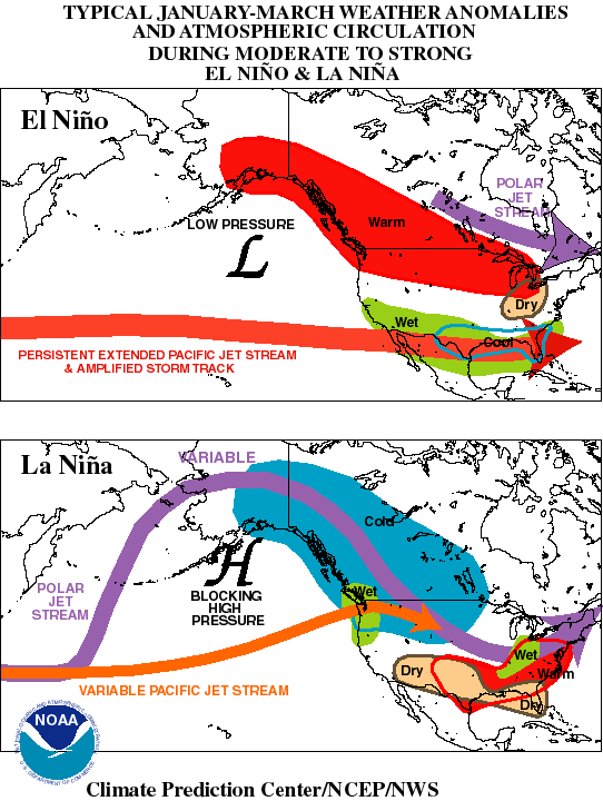
As far as patterns go, South Texas Storms, I don't think there is a set one. You could have several winters in a row with ENSO conditions of Nina or Nino. Don't forget that last winter the Nina had incredibly strong (i.e. cold) conditions just about off the charts. Even if a Nina does take shape for this winter, it shouldn't be as severe and ... perhaps ... perhaps ... drought conditions might lessen. I realize this is all speculative and we have a long ways to go.
South Texas Storms wrote:Thanks Portastorm. Isn't it true that the ENSO model forecasts run in the early summer months are the most unrelable runs of the year? I thought I read that somewhere...
Portastorm wrote:South Texas Storms wrote:Thanks Portastorm. Isn't it true that the ENSO model forecasts run in the early summer months are the most unrelable runs of the year? I thought I read that somewhere...
I really don't know the answer to your question, STS. I'll try and do some research on that and I'm sure others here may opine as well. Like any other computer modeling, I do know that some long-range models do better than others depending on the ENSO state.

Users browsing this forum: No registered users and 166 guests


