

From this morning's Jeff Master's post at the WeatherUnderground tropical page:
First named storm in the Atlantic possible next week
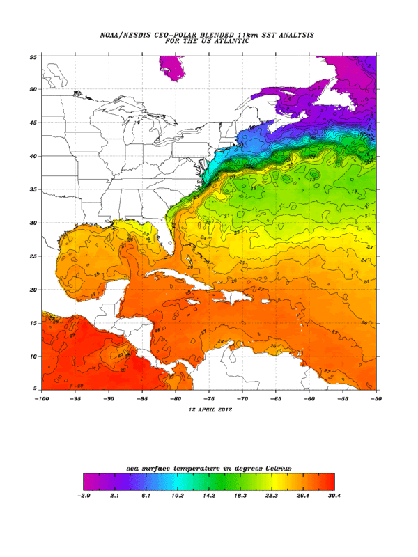
Both the GFS and ECMWF models are predicting that an extratropical "cut-off" low will separate from the jet stream early next week several hundred miles east of Bermuda, and linger for several days over subtropical waters with temperatures in the 22 - 24°C range. These ocean temperatures may be warm enough to allow the storm to organize into a named subtropical storm. However, climatology argues against such an occurrence; there has been only one named April storm in the Atlantic since 1851. If a subtropical storm does form next week, it would probably not affect any land areas.
Jeff Masters
First named storm in the Atlantic possible this week :Is 91L
Moderator: S2k Moderators
Forum rules

The posts in this forum are NOT official forecasts and should not be used as such. They are just the opinion of the poster and may or may not be backed by sound meteorological data. They are NOT endorsed by any professional institution or STORM2K. For official information, please refer to products from the National Hurricane Center and National Weather Service.
First named storm in the Atlantic possible this week :Is 91L
0 likes
The following post is NOT an official forecast and should not be used as such. It is just the opinion of the poster and may or may not be backed by sound meteorological data. It is NOT endorsed by any professional institution including storm2k.org For Official Information please refer to the NHC and NWS products.
-
cycloneye

- Admin

- Posts: 149275
- Age: 69
- Joined: Thu Oct 10, 2002 10:54 am
- Location: San Juan, Puerto Rico
Re: First named storm in the Atlantic possible next week
ECMWF in it's 12z run continues to have the development scenario for the low pressure.

0 likes
Visit the Caribbean-Central America Weather Thread where you can find at first post web cams,radars
and observations from Caribbean basin members Click Here
and observations from Caribbean basin members Click Here
-
wxman57

- Moderator-Pro Met

- Posts: 23172
- Age: 68
- Joined: Sat Jun 21, 2003 8:06 pm
- Location: Houston, TX (southwest)
Re: First named storm in the Atlantic possible next week
This is the reason it's very hard to have fewer than 10 named storms these days. Prior to the past decade, there would not even have been the consideration of naming such a system.
0 likes
Re: First named storm in the Atlantic possible next week
wxman57 wrote:This is the reason it's very hard to have fewer than 10 named storms these days. Prior to the past decade, there would not even have been the consideration of naming such a system.
Every year now seems to be good for at least two of these cutoff lows developing in the open Atlantic with another two or three getting close enough where they go code red in the TWO.
0 likes

This seems as good a time as any to point out the following recommendation the NHC is putting forward at the ongoing RA IV Hurricane Committee meeting regarding the definition of a subtropical system:
Update definition of subtropical cyclone
RSMC Miami
April 2012
-The current definition of subtropical cyclone is too vague. It defines a subtropical cyclone as having characteristics of both tropical and extratropical cyclones, but doesn’t indicate what those specific defining characteristics are. Adding specificity to the definition would promote greater consistency among forecasters in its application, and promote better understanding with users.
- Adopt the following definition for subtropical cyclone:
A non-frontal low-pressure system that has characteristics of both tropical and extratropical cyclones. Like tropical cyclones, they are non-frontal, synoptic-scale cyclones that originate over tropical or subtropical waters, and have a closed surface wind circulation about a well-defined center. In addition, they have organized moderate to deep convection, but lack a central dense overcast. Unlike tropical cyclones, subtropical cyclones derive a significant proportion of their energy from baroclinic sources, and are generally cold-core in the upper troposphere, often being associated with an upper-level low or trough. In comparison to tropical cyclones, these systems generally have a radius of maximum winds occurring relatively far from the center (usually greater than 60 n mi), and generally have a less symmetric wind field and distribution of convection.
0 likes
-
cycloneye
- Admin
- Posts: 149275
- Age: 69
- Joined: Thu Oct 10, 2002 10:54 am
- Location: San Juan, Puerto Rico
Re: First named storm in the Atlantic possible next week
12z Euro continues to develop the low,now only three days out.

0 likes
Visit the Caribbean-Central America Weather Thread where you can find at first post web cams,radars
and observations from Caribbean basin members Click Here
and observations from Caribbean basin members Click Here

-
AJC3

- Admin
- Posts: 4153
- Age: 62
- Joined: Tue Aug 31, 2004 7:04 pm
- Location: Ballston Spa, New York
- Contact:
Just a reminder for folks that the 26C/80F SST threshold assumes sort of a "standard deep tropical atmosphere". In other words, if mid/upper level tropospheric temperatures are typical of what you would find in or near the MDR, then it's safe to use that number. In this case, it's not, since the surface low is being forecast to develop beneath a cold core 500MB cutoff low. Systems that have their origins in higher latitudes, and/or beneath cutoff cold core lows have a lower SST threshold for central convection to develop or maintain itself since the lower SST's are offset by cooler mid level temperatures.
That being said, a lot has to go right for a deep layer cold core cutoff to acquire sufficient quasi-tropical characteristics to be subjectively called a TC or even an STC for that matter.
Generally, I bet against these types of cyclones becoming STCs/TCs, given the time of year, shear/stability issues, etc. However, you'll probably eventually see an invest out of this, and possibly a Special TWO or two. Happy bear watching.
0 likes
-
cycloneye
- Admin
- Posts: 149275
- Age: 69
- Joined: Thu Oct 10, 2002 10:54 am
- Location: San Juan, Puerto Rico
Re: First named storm in the Atlantic possible next week
TAFB has it in 24 hours as a frontal low. Let's see if it detaches from it or not.

0 likes
Visit the Caribbean-Central America Weather Thread where you can find at first post web cams,radars
and observations from Caribbean basin members Click Here
and observations from Caribbean basin members Click Here
-
AJC3
- Admin
- Posts: 4153
- Age: 62
- Joined: Tue Aug 31, 2004 7:04 pm
- Location: Ballston Spa, New York
- Contact:
Re: First named storm in the Atlantic possible next week
cycloneye wrote:TAFB has it in 24 hours as a frontal low. Let's see if it detaches from it or not.
Interesting to see that the low is forecast to intensify into a 48kt+ storm as opposed to remaining a 34-47kt gale center.
0 likes
-
MGC

- S2K Supporter

- Posts: 5940
- Joined: Sun Mar 23, 2003 9:05 pm
- Location: Pass Christian MS, or what is left.
Re: First named storm in the Atlantic possible this week
The low is attached to a front this morning.....weather (pun intended) or not if it can detach from the front is one thing....cool SST are another. Small chance of become a SST right now.....MGC
0 likes
-
Kingarabian

- S2K Supporter
- Posts: 16348
- Joined: Sat Aug 08, 2009 3:06 am
- Location: Honolulu, Hawaii
-
cycloneye
- Admin
- Posts: 149275
- Age: 69
- Joined: Thu Oct 10, 2002 10:54 am
- Location: San Juan, Puerto Rico
Re: First named storm in the Atlantic possible this week
This area is now invest 91L,so the thread is locked. Go to ActiveStorms/invests forum to get all the information and to make comments.
0 likes
Visit the Caribbean-Central America Weather Thread where you can find at first post web cams,radars
and observations from Caribbean basin members Click Here
and observations from Caribbean basin members Click Here
Who is online
Users browsing this forum: No registered users and 144 guests