Global model runs discussion
Moderator: S2k Moderators
-
Kingarabian

- S2K Supporter

- Posts: 16348
- Joined: Sat Aug 08, 2009 3:06 am
- Location: Honolulu, Hawaii
-
cycloneye

- Admin

- Posts: 149275
- Age: 69
- Joined: Thu Oct 10, 2002 10:54 am
- Location: San Juan, Puerto Rico
Re: Global Model Runs Discussion
ROCK,it was better to not stay up  as the EURO still does not have anything in the SW or Western Caribbean on day ten,but it has a weak low in the EPAC.

0 likes
Visit the Caribbean-Central America Weather Thread where you can find at first post web cams,radars
and observations from Caribbean basin members Click Here
and observations from Caribbean basin members Click Here
-
Dean4Storms
- S2K Supporter
- Posts: 6358
- Age: 63
- Joined: Sun Aug 31, 2003 1:01 pm
- Location: Miramar Bch. FL
-
tolakram
- Admin
- Posts: 20179
- Age: 62
- Joined: Sun Aug 27, 2006 8:23 pm
- Location: Florence, KY (name is Mark)
Re: Global Model Runs Discussion
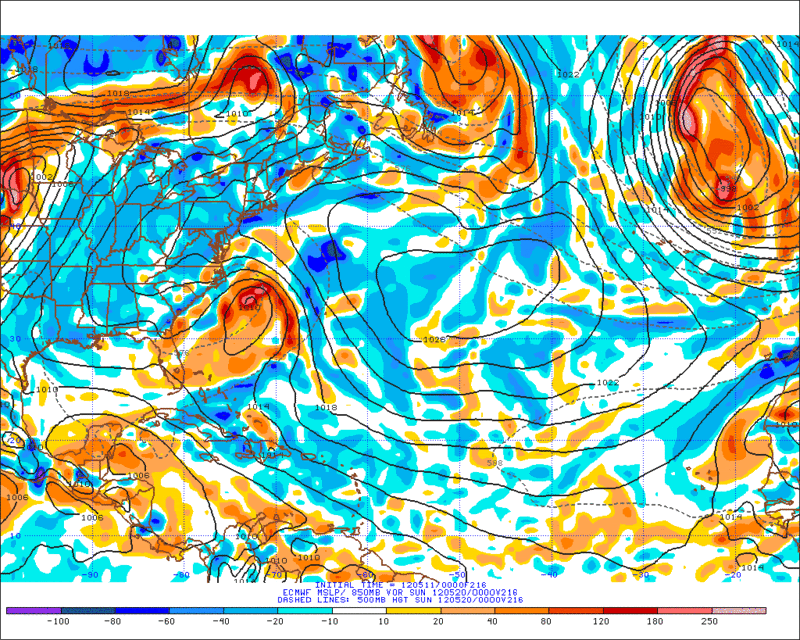
Looks like the first EPAC storm may be on the horizon. Will we get one named before the 15th?

This may be the blob in the lower right of this image.

This may be the blob in the lower right of this image.
0 likes
M a r k
- - - - -
Join us in chat: Storm2K Chatroom Invite. Android and IOS apps also available.
The posts in this forum are NOT official forecasts and should not be used as such. Posts are NOT endorsed by any professional institution or STORM2K.org. For official information and forecasts, please refer to NHC and NWS products.
-
cycloneye
- Admin
- Posts: 149275
- Age: 69
- Joined: Thu Oct 10, 2002 10:54 am
- Location: San Juan, Puerto Rico
Re: Global Model Runs Discussion
The operational ECMWF doesn't have anything so far,but the Ensembles have a hint in the SW Caribbean.

Uploaded with imageshack.us
Uploaded with imageshack.us
0 likes
Visit the Caribbean-Central America Weather Thread where you can find at first post web cams,radars
and observations from Caribbean basin members Click Here
and observations from Caribbean basin members Click Here
-
cycloneye
- Admin
- Posts: 149275
- Age: 69
- Joined: Thu Oct 10, 2002 10:54 am
- Location: San Juan, Puerto Rico
Re: Global Model Runs Discussion
Also,the Canadian ensembles hint on some type of development or at least plenty of needed moisture for Florida.

0 likes
Visit the Caribbean-Central America Weather Thread where you can find at first post web cams,radars
and observations from Caribbean basin members Click Here
and observations from Caribbean basin members Click Here
-
Dean4Storms
- S2K Supporter
- Posts: 6358
- Age: 63
- Joined: Sun Aug 31, 2003 1:01 pm
- Location: Miramar Bch. FL
-
cycloneye
- Admin
- Posts: 149275
- Age: 69
- Joined: Thu Oct 10, 2002 10:54 am
- Location: San Juan, Puerto Rico
Re: Global Model Runs Discussion
SFLcane wrote:i'd say theres a better shot for development in the epac.
There is a good chance that it may occur as GFS has it and is not long range,but in less than 100 hours.

Uploaded with imageshack.us
0 likes
Visit the Caribbean-Central America Weather Thread where you can find at first post web cams,radars
and observations from Caribbean basin members Click Here
and observations from Caribbean basin members Click Here
-
wxman57

- Moderator-Pro Met

- Posts: 23172
- Age: 68
- Joined: Sat Jun 21, 2003 8:06 pm
- Location: Houston, TX (southwest)
Re: Global Model Runs Discussion
GFS is backing off on Caribbean development now. For some reason it was developing a deep upper low over the Caribbean over the past few days and trying to develop a surface feature. It does this a lot in that region this time of year and it's wrong most of the time.
0 likes
-
Kingarabian
- S2K Supporter
- Posts: 16348
- Joined: Sat Aug 08, 2009 3:06 am
- Location: Honolulu, Hawaii


Re: Global Model Runs Discussion
I should of known not to trust ther GFS even in the mid range,shame on me. The EPAC is where the actions going to be in my opinion.
0 likes

Re: Global Model Runs Discussion
boca wrote:I should of known not to trust ther GFS even in the mid range,shame on me. The EPAC is where the actions going to be in my opinion.
while I dislike the GFS on some fronts I think the sign of lowering pressures should be taken in to account. Be it EPAC or SWcarib. If we had more model support then I would be all over it but when the CMC doesnt see it then I pretty much know that the GFS is seeing a phantom development. JMO...
0 likes

-
cycloneye
- Admin
- Posts: 149275
- Age: 69
- Joined: Thu Oct 10, 2002 10:54 am
- Location: San Juan, Puerto Rico
Re: Global Model Runs Discussion
This is from the 10:05 UTC discussion by NHC of the EPAC:
A
COUPLE OF LOW LEVEL CYCLONIC CIRCULATIONS ARE NOTED ALONG THE
MONSOON TROUGH...ONE IN THE VICINITY OF 08N112W AND A SECOND IN
THE VICINITY OF 08N104W. MOST RECENT SCATTEROMETER PASSES SHOWED
SW TO W WINDS NEAR 20 KT BLOWING INTO THESE LOW LEVEL CYCLONIC
CIRCULATIONS. GLOBAL MODELS ARE NOT IN AGREEMENT WITH THE
EVOLUTION OF THESE FEATURES. THE GFS IS MORE AGGRESSIVE TRYING
TO DEVELOP A TROPICAL CYCLONE WHILE THE UKMET KEEPS A WEAK LOW
PRES SYSTEM MOVING NW DURING THE NEXT FEW DAYS. THE FORECAST
FOLLOWS THE UKMET SOLUTION. THE GFS MODEL IS PERHAPS SHOWING
CONVECTIVE FEEDBACK. HOWEVER...IT IS THE TIME OF THE YEAR TO SEE
THE FIRST SIGNS OF TROPICAL DEVELOPMENT ACROSS THIS AREA. MAY 15
MARKS THE BEGINNING OF THE TROPICAL SEASON IN THE EASTERN NORTH
PACIFIC. LONG-TERM AVERAGES OF TROPICAL STORMS...HURRICANES AND
MAJOR HURRICANES IN THIS BASIN ARE 15...9...AND 4 RESPECTIVELY.
http://asp1.sbs.ohio-state.edu/tropical ... 51109.tdsc
0 likes
Visit the Caribbean-Central America Weather Thread where you can find at first post web cams,radars
and observations from Caribbean basin members Click Here
and observations from Caribbean basin members Click Here
-
Dean4Storms
- S2K Supporter
- Posts: 6358
- Age: 63
- Joined: Sun Aug 31, 2003 1:01 pm
- Location: Miramar Bch. FL
-
cycloneye
- Admin
- Posts: 149275
- Age: 69
- Joined: Thu Oct 10, 2002 10:54 am
- Location: San Juan, Puerto Rico
Re: Global Model Runs Discussion
This is not invest 90E as what this Euro run shows is more east in longitude. The 12z ECMWF has Hurricane Bud close to the CA coast.

0 likes
Visit the Caribbean-Central America Weather Thread where you can find at first post web cams,radars
and observations from Caribbean basin members Click Here
and observations from Caribbean basin members Click Here
-
cycloneye
- Admin
- Posts: 149275
- Age: 69
- Joined: Thu Oct 10, 2002 10:54 am
- Location: San Juan, Puerto Rico
Re: Global Model Runs Discussion
Another example of how the models change constantly has occured with the ECMWF as yesterday it had a hurricane just SW of El Salvador and today it has a weak storm.Also,GFS goes back and forth with the Caribbean system,in terms of track and intensity.
0 likes
Visit the Caribbean-Central America Weather Thread where you can find at first post web cams,radars
and observations from Caribbean basin members Click Here
and observations from Caribbean basin members Click Here

Re: Global Model Runs Discussion
From Dr Jeff Masters Blog today:
In the Atlantic, where hurricane season officially starts on June 1, the action may also be about to heat up. For the past several days, the GFS model has been consistently predicting the development of a subtropical storm in the Western Caribbean, or waters near Florida, sometime May 19 - May 21. The European Center model has not been on board with this, but has been predicting a very moist flow of tropical air will develop, bringing heavy rains to Florida May 19 - 20. So, it is possible we will see the Atlantic's first named storm occur in May this year, but the models are very unreliable this far out.
In the Atlantic, where hurricane season officially starts on June 1, the action may also be about to heat up. For the past several days, the GFS model has been consistently predicting the development of a subtropical storm in the Western Caribbean, or waters near Florida, sometime May 19 - May 21. The European Center model has not been on board with this, but has been predicting a very moist flow of tropical air will develop, bringing heavy rains to Florida May 19 - 20. So, it is possible we will see the Atlantic's first named storm occur in May this year, but the models are very unreliable this far out.
0 likes
-
SFLcane

- S2K Supporter
- Posts: 10281
- Age: 48
- Joined: Sat Jun 05, 2010 1:44 pm
- Location: Lake Worth Florida
Re: Global Model Runs Discussion
cmc now also shows moisture heading for florida just in time for the tip of rainy season.

0 likes
Who is online
Users browsing this forum: No registered users and 62 guests