
Global model runs discussion
Moderator: S2k Moderators
-
Aric Dunn
- Category 5

- Posts: 21238
- Age: 43
- Joined: Sun Sep 19, 2004 9:58 pm
- Location: Ready for the Chase.
- Contact:
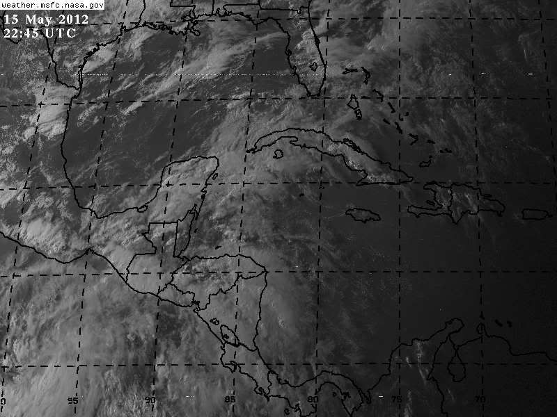
It appears the models are now at leasr in some agreement on something developing quickly as it leaves the nw carribean Crosses Florida then races off to the nne. The timing and strength prior to Florida is key. but from the.models it seems something will take a shot at development over the next few days... Looking at sat this morning convection is on the increase in the area ....
0 likes
Note: If I make a post that is brief. Please refer back to previous posts for the analysis or reasoning. I do not re-write/qoute what my initial post said each time.
If there is nothing before... then just ask
Space & Atmospheric Physicist, Embry-Riddle Aeronautical University,
I believe the sky is falling...
If there is nothing before... then just ask
Space & Atmospheric Physicist, Embry-Riddle Aeronautical University,
I believe the sky is falling...
-
cycloneye

- Admin

- Posts: 149368
- Age: 69
- Joined: Thu Oct 10, 2002 10:54 am
- Location: San Juan, Puerto Rico
Re: Global Model Runs Discussion
Very interesting to see the Global Tropical Hazards site talking about Western Caribbean Development after May 23rd.

http://www.cpc.ncep.noaa.gov/products/p ... /ghazards/
http://www.cpc.ncep.noaa.gov/products/p ... /ghazards/
0 likes
Visit the Caribbean-Central America Weather Thread where you can find at first post web cams,radars
and observations from Caribbean basin members Click Here
and observations from Caribbean basin members Click Here
-
Aric Dunn
- Category 5
- Posts: 21238
- Age: 43
- Joined: Sun Sep 19, 2004 9:58 pm
- Location: Ready for the Chase.
- Contact:
That is rather interesting
0 likes
Note: If I make a post that is brief. Please refer back to previous posts for the analysis or reasoning. I do not re-write/qoute what my initial post said each time.
If there is nothing before... then just ask
Space & Atmospheric Physicist, Embry-Riddle Aeronautical University,
I believe the sky is falling...
If there is nothing before... then just ask
Space & Atmospheric Physicist, Embry-Riddle Aeronautical University,
I believe the sky is falling...
-
tolakram
- Admin
- Posts: 20184
- Age: 62
- Joined: Sun Aug 27, 2006 8:23 pm
- Location: Florence, KY (name is Mark)
Re: Global Model Runs Discussion
Early season storms like to develop in the western Caribbean, and for that matter models love to spin up the first few EPAC storms in the western Caribbean. I wonder if some of this, like the tropical hazard areas, is based on historical averages.
0 likes
M a r k
- - - - -
Join us in chat: Storm2K Chatroom Invite. Android and IOS apps also available.
The posts in this forum are NOT official forecasts and should not be used as such. Posts are NOT endorsed by any professional institution or STORM2K.org. For official information and forecasts, please refer to NHC and NWS products.
-
jasons2k

- Storm2k Executive
- Posts: 8290
- Age: 52
- Joined: Wed Jul 06, 2005 12:32 pm
- Location: The Woodlands, TX
Re: Global Model Runs Discussion
Interesting stuff: http://www.heraldtribune.com/article/20 ... ane-season
Tropical storm forecast kick-starts the 2012 hurricane season
By Kate Spinner
Published: Wednesday, May 16, 2012 at 1:00 a.m.
The 2012 hurricane season might get an early start, with the possibility of a tropical depression or storm in the western Caribbean some time next week, according to a cutting-edge forecast Tuesday by federal scientists.
The Climate Prediction Center predicted moderate chances that a tropical depression or a storm will form in the Caribbean during the last week of May.
Even if no storm develops, the prediction signals that the Atlantic is becoming primed for tropical activity as June 1, the official start of the six-month hurricane season, nears.
"It's something to pay attention to. It might be a little earlier than normal," said Eric Blake, a specialist with the National Hurricane Center.
While the two-week tropical hazard forecasts by the Climate Prediction Center are not very accurate now, meteorologists there are working with the National Hurricane Center to improve them. Within a few years, the two agencies plan to start making a joint two-week forecast, with the hurricane center taking the lead on the first week and the climate center handling the second, said Blake, who gave a presentation about the project at the Governor's Hurricane Conference here on Tuesday.
He said the hurricane center began working with the climate center on the two-week outlook shortly after the busy 2005 hurricane season.
"The challenge has really been eliminating the false alarms," Blake said.
The two-week outlook mostly relies on thunderstorm activity around the global tropics to predict where chances are increased for a tropical storm or depression to form. Clusters of thunderstorms occasionally move around the globe in a weather pattern called the Madden-Julian Oscillation or MJO. When the thunderstorms are over the Caribbean and Africa, the chances for tropical storms to develop in the Atlantic increase, Blake said.
But because weather is so variable, forecasts that extend beyond a week tend to have a large margin of error. The five-day forecast for tropical activity, however, is getting much better.
Blake said the hurricane center will experiment this year, in-house, with predicting the formation of tropical storms five days in advance. If the forecasts pan out, weather buffs, fishermen, shipping businesses, emergency planners and those in the oil and gas extraction industries could benefit from those forecasts beginning next year.
0 likes

Second Half of May is going to Rock
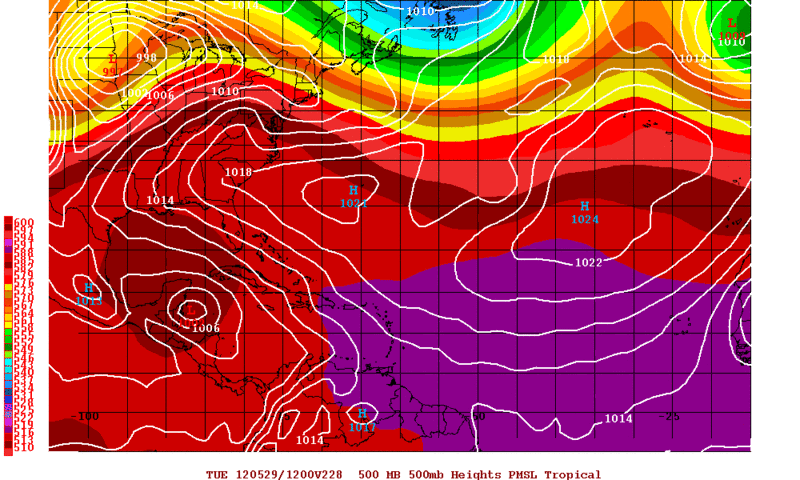
I suggest following the models closely at this current time because they seem to be very interesting around now. They are mostly all advertising lowering pressures around the Epac and Caribbean areas with that typical late May energy that slowly consolidates as the monsoonal trough gears upwards.
As for the beginning of TS Aletta in the Epac, the GFDL May 11 12z run showed it becoming a MAJOR hurricane hours before the official start to the Epac hurricane season! Did anyone else notice this mind-blowing item? I couldn't believe that and for anyone who doesn't know much about the Epac, that is insane. It moved it NW as it did this!! The GFDL didn't even develop Aletta at times just before it officially was declared a TD; what was the idea it had? It ended up radically flipping around and I guess the track played a major role in that.
The models are hinting at extraordinary features this May in this region. Here I thought a TS would be pretty interesting alone which ended up panning out. Around 72-168 hours from now more development is showing up close to the eastern edge which will spawn something significant. The conditions look great and something tells me wind shear won't be a factor. Something else, why is there no NOAA-HFIP HWRF active for any of these systems?
Zeroing in on future Bud (which may or may not be 92E), what is amazing is the model consistency and agreement...pretty much every model shows at least a TD with most way stronger and even the HWRF run for Aletta showed it popping up to the east! The Euro picked it up 120 hours ago and the GFS is very bullish with it as of recently showing what looks to be close to major hurricane strength...each run becoming more bullish. At the same time, it shows it moving slowly to the north very close to Mexico while at that high intensity.
The following GFS model images of 168 hours show a dream pattern with all the "ensembles" (not model ensembles) of interesting/crazy weather IMO:

Powerful Epac TC off the coast, but overall you can see in North America what could be a tornado outbreak unfolding with that massive trough and nice low. Its early, but fair game because the start is within 168 hours. After the pattern NA has experience in recent weeks, that vast swath of low pressure is quite something. Some minor disturbance in the Caribbean is sort of apparent but sketchy...most likely an Invest at least. All this with a very warm pattern (Heat Wave please, IMBY) coming, makes for an interesting period.

Even more powerful Epac hurricane here with the ominous system over NA continuing and becoming stronger. I think this run showed a TD/TS in the Caribbean ejecting right over south Florida into the Atlantic.
Recent Addition:

This is the 0z Euro for today, WOW. Doesn't show anything impressive for the Epac but that NA system with the very deep trough looks very ominous even though I don't know perfectly what exactly that translates to. I don't think I've ever seen anything like that on these format of model runs. I forget what its called but its showing twin lows (potent ones) connected in trough formation which I believe is a cut-off low at the bottom. Either way you cut it, model agreement is increasing and starting to become consistent and this screams one word...potential. 7 days I noticed is when the models really pick these events up so the countdown is on to scary.
As for the beginning of TS Aletta in the Epac, the GFDL May 11 12z run showed it becoming a MAJOR hurricane hours before the official start to the Epac hurricane season! Did anyone else notice this mind-blowing item? I couldn't believe that and for anyone who doesn't know much about the Epac, that is insane. It moved it NW as it did this!! The GFDL didn't even develop Aletta at times just before it officially was declared a TD; what was the idea it had? It ended up radically flipping around and I guess the track played a major role in that.
The models are hinting at extraordinary features this May in this region. Here I thought a TS would be pretty interesting alone which ended up panning out. Around 72-168 hours from now more development is showing up close to the eastern edge which will spawn something significant. The conditions look great and something tells me wind shear won't be a factor. Something else, why is there no NOAA-HFIP HWRF active for any of these systems?
Zeroing in on future Bud (which may or may not be 92E), what is amazing is the model consistency and agreement...pretty much every model shows at least a TD with most way stronger and even the HWRF run for Aletta showed it popping up to the east! The Euro picked it up 120 hours ago and the GFS is very bullish with it as of recently showing what looks to be close to major hurricane strength...each run becoming more bullish. At the same time, it shows it moving slowly to the north very close to Mexico while at that high intensity.
The following GFS model images of 168 hours show a dream pattern with all the "ensembles" (not model ensembles) of interesting/crazy weather IMO:
Powerful Epac TC off the coast, but overall you can see in North America what could be a tornado outbreak unfolding with that massive trough and nice low. Its early, but fair game because the start is within 168 hours. After the pattern NA has experience in recent weeks, that vast swath of low pressure is quite something. Some minor disturbance in the Caribbean is sort of apparent but sketchy...most likely an Invest at least. All this with a very warm pattern (Heat Wave please, IMBY) coming, makes for an interesting period.
Even more powerful Epac hurricane here with the ominous system over NA continuing and becoming stronger. I think this run showed a TD/TS in the Caribbean ejecting right over south Florida into the Atlantic.
Recent Addition:
This is the 0z Euro for today, WOW. Doesn't show anything impressive for the Epac but that NA system with the very deep trough looks very ominous even though I don't know perfectly what exactly that translates to. I don't think I've ever seen anything like that on these format of model runs. I forget what its called but its showing twin lows (potent ones) connected in trough formation which I believe is a cut-off low at the bottom. Either way you cut it, model agreement is increasing and starting to become consistent and this screams one word...potential. 7 days I noticed is when the models really pick these events up so the countdown is on to scary.
0 likes
-
USTropics
- Professional-Met

- Posts: 2738
- Joined: Sun Aug 12, 2007 3:45 am
- Location: Florida State University
Re: Second Half of May is going to Rock
Cyclenall wrote:I forget what its called but its showing twin lows (potent ones) connected in trough formation which I believe is a cut-off low at the bottom.
I believe what you're referring to is an omega block and it usually coincides with a cut off low being left behind as the jet stream begins to retreat to the north.
0 likes
-
Meso

- Category 5
- Posts: 1609
- Age: 39
- Joined: Mon Aug 09, 2004 12:14 pm
- Location: South Africa
- Contact:
Re: Global Model Runs Discussion
I am here to post everyone's favourite model  The CMC
The CMC has a low developing in the Caribbean in 102 hours (not long at all) which it then moves over south Florida at hour 144 as a 1002mb low. It then moves it up the coast, deepening to a 990mb low off North Carolina.
While we are all aware that the CMC is aggressive, it's interesting to note that it does in fact have other model support for the scenario.
120 Hours

144 Hours

The CMC has a low developing in the Caribbean in 102 hours (not long at all) which it then moves over south Florida at hour 144 as a 1002mb low. It then moves it up the coast, deepening to a 990mb low off North Carolina.
While we are all aware that the CMC is aggressive, it's interesting to note that it does in fact have other model support for the scenario.
120 Hours
144 Hours
0 likes
-
cycloneye
- Admin
- Posts: 149368
- Age: 69
- Joined: Thu Oct 10, 2002 10:54 am
- Location: San Juan, Puerto Rico
Re:
CrazyC83 wrote:What other models back that up?
The ECMWF has the low off Carolinas at 96 hours.

0 likes
Visit the Caribbean-Central America Weather Thread where you can find at first post web cams,radars
and observations from Caribbean basin members Click Here
and observations from Caribbean basin members Click Here
Re: Second Half of May is going to Rock
USTropics wrote:Cyclenall wrote:I forget what its called but its showing twin lows (potent ones) connected in trough formation which I believe is a cut-off low at the bottom.
I believe what you're referring to is an omega block and it usually coincides with a cut off low being left behind as the jet stream begins to retreat to the north.
I wasn't talking about the formation of the jet stream. Everything else you said was close enough.
All the models continue to show future Bud soon. The consistency and agreement could not be more strong here, every single model shows a significant TC...most likely a strong hurricane...heading west and then north right towards Mexico around 168 hours. I've never seen such perfect agreement for a May TC. The HWRF and GFDL model runs for Aletta now all show Bud to the east in all scenarios so I'd say the chances of TS Bud or higher are 99%. If your one of the lucky folks who live along the Mexican coastline or even more inland, go over your hurricane peps. now.
A new development with the GFS runs show now future Carlotta in the Epac forming close to the Mexican coast as well and bringing it inland soon after becoming a TS. The time-frame is around 114-154 hours. If this occurs then it will be the first time in recorded history the Epac has 3 tropical cyclones in the month of May. I'm not surprised.
The Canadian is more bullish on a system forming in the western Atlantic and quickly moving up the seaboard. Other models are starting to hint at this again.

GFS showing Bud and Carlotta at the same time. Note what is going on over North America
0 likes

Re: Global Model Runs Discussion
Funny, during the prior week, the EURO hardly supported much argument for early W. Caribbean development. The GFS certainly seemed persistent in "attempting" to develop a Depression/Storm somewhere south (or near) W. Cuba...., and finally backed off "that" solution. Then, we hear about the Super Duper Secret Cutting Edge Federal Scientist Forecast of potential W. Carib. development............
"Tropical storm forecast kick-starts the 2012 hurricane season
By Kate Spinner (Published: Wednesday, May 16, 2012 at 1:00 a.m.)-
The 2012 hurricane season might get an early start, with the possibility of a tropical depression or storm in the western Caribbean some time next week, according to a cutting-edge forecast Tuesday by federal scientists. The Climate Prediction Center predicted moderate chances that a tropical depression or a storm will form in the Caribbean during the last week of May...."
As of this morning, even the CMC barely still attempts to "jump start" a quickly departing Bermuda bound weak low ("aay"?). So it probably can safely be stated that the Atlantic Hurricane Season will begin June 1, and no Atlantic tropical development should occur between now and the end of next week ( ....or at least "probably a moderate likelihood of no imminent threat of near term development - maybe") LOL
Let the WATCH & WAIT GAMES BEGIN!
(The prceeding statement is neither a prediction of development, of any threat nor a forecast. Please consult with all National Hurricane Center advises for any official forecast prior to any decisions impacting all wagers, bets, or decisions regarding life & limb
 )
)
0 likes
Andy D
(For official information, please refer to the NHC and NWS products.)
(For official information, please refer to the NHC and NWS products.)
-
Rgv20

- S2K Supporter

- Posts: 2466
- Age: 39
- Joined: Wed Jan 05, 2011 5:42 pm
- Location: Edinburg/McAllen Tx
0zGFS has a developing Tropical System in NW Caribbean in around 9 to 10 days...
0 likes
The following post is NOT an official forecast and should not be used as such. It is just the opinion of the poster and may or may not be backed by sound meteorological data. It is NOT endorsed by any professional institution including storm2k.org For Official Information please refer to the NHC and NWS products.
-
Ivanhater

- Storm2k Moderator

- Posts: 11221
- Age: 39
- Joined: Fri Jul 01, 2005 8:25 am
- Location: Pensacola


Re: Global Model Runs Discussion
0Z GFS has nada up to 183hr....does take that low out of the carib and moves it over Cuba and out. Never really closes it off though...
edit: nothing really cooking in the carib in the very long range.....lower pressures though...
edit: nothing really cooking in the carib in the very long range.....lower pressures though...
Last edited by ROCK on Mon May 21, 2012 11:46 pm, edited 1 time in total.
0 likes
Re: Global Model Runs Discussion
Ivanhater wrote:12z Euro tries to spin something up in the long range in the GOM
Uploaded with ImageShack.us
now that is interesting....I havent been checking the 12Z EURO lately....still shaking the cobwebs off my links....
0 likes
Who is online
Users browsing this forum: No registered users and 37 guests