Low Pressure by the Carolinas' coast (Is invest 93L)

This is the general tropical discussion area. Anyone can take their shot at predicting a storms path.

Moderator: S2k Moderators

Forum rules

The posts in this forum are NOT official forecasts and should not be used as such. They are just the opinion of the poster and may or may not be backed by sound meteorological data. They are NOT endorsed by any professional institution or STORM2K. For official information, please refer to products from the National Hurricane Center and National Weather Service.

Help Support Storm2K
Message
Author
User avatar
NDG
S2K Supporter
S2K Supporter
Posts: 14934
Joined: Sun Jul 09, 2006 10:14 pm
Location: Orlando, FL

Low Pressure by the Carolinas' coast (Is invest 93L)

#1 Postby NDG » Sat May 19, 2012 6:22 am

As if the low pressure started taking some subtropical charecteristics during the night. Very interesting little system with a tight LLC.

Image
Image
0 likes   

User avatar
NDG
S2K Supporter
S2K Supporter
Posts: 14934
Joined: Sun Jul 09, 2006 10:14 pm
Location: Orlando, FL

#2 Postby NDG » Sat May 19, 2012 6:42 am

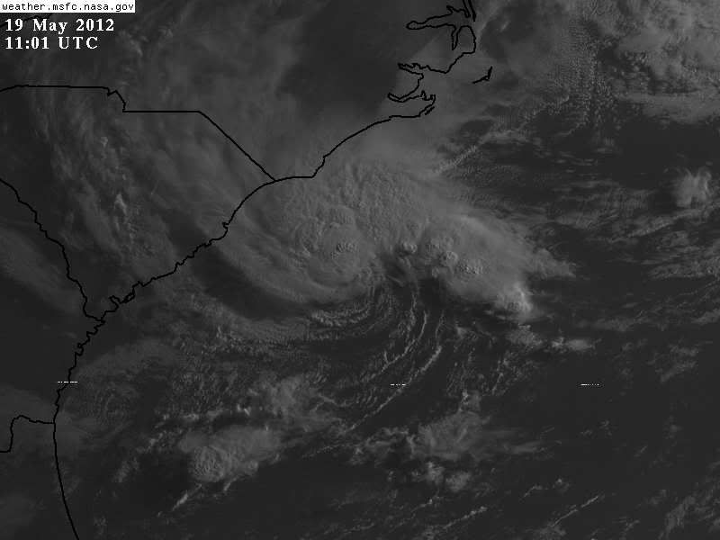
Reports from buoy 41013 located just north of the low pressure center.

Conditions at 41013 as of
(6:50 am EDT)
1050 GMT on 05/19/2012:

Wind Direction (WDIR): NNE ( 20 deg true )
Wind Speed (WSPD): 25.3 kts
Wind Gust (GST): 31.1 kts
Wave Height (WVHT): 8.5 ft
Dominant Wave Period (DPD): 7 sec
Average Period (APD): 5.3 sec
Mean Wave Direction (MWD): ENE ( 65 deg true )
Atmospheric Pressure (PRES): 29.91 in
Pressure Tendency (PTDY): +0.01 in ( Rising )
Air Temperature (ATMP): 66.9 °F
Water Temperature (WTMP): 73.6 °F
Dew Point (DEWP): 65.3 °F

http://www.ndbc.noaa.gov/station_page.php?station=41013
0 likes   

User avatar
HURAKAN
Professional-Met
Professional-Met
Posts: 46086
Age: 37
Joined: Thu May 20, 2004 4:34 pm
Location: Key West, FL
Contact:

#3 Postby HURAKAN » Sat May 19, 2012 7:16 am

SPECIAL TROPICAL WEATHER OUTLOOK
NWS NATIONAL HURRICANE CENTER MIAMI FL
815 AM EDT SAT MAY 19 2012

FOR THE NORTH ATLANTIC...CARIBBEAN SEA AND THE GULF OF MEXICO...

A NON-TROPICAL AREA OF LOW PRESSURE LOCATED ABOUT 120 MILES
SOUTHEAST OF MYRTLE BEACH SOUTH CAROLINA IS PRODUCING SHOWERS AND
THUNDERSTORMS AS IT INTERACTS WITH A MID- TO UPPER-LEVEL TROUGH.
ANY DEVELOPMENT OF THIS SYSTEM AS A TROPICAL OR SUBTROPICAL CYCLONE
IS EXPECTED TO BE SLOW TO OCCUR AS IT MOVES LITTLE OVER THE NEXT
DAY OR SO. THIS SYSTEM HAS A LOW CHANCE...20 PERCENT...OF BECOMING
A TROPICAL OR SUBTROPICAL CYCLONE DURING THE NEXT 48 HOURS. FOR
ADDITIONAL INFORMATION ON THIS SYSTEM...PLEASE SEE PRODUCTS FROM
YOUR LOCAL NATIONAL WEATHER SERVICE OFFICE AND HIGH SEAS FORECASTS
ISSUED BY THE NATIONAL WEATHER SERVICE...UNDER AWIPS HEADER
NFDHSFAT1 AND WMO HEADER FZNT01 KWBC. ADDITIONAL SPECIAL TROPICAL
WEATHER OUTLOOKS WILL BE ISSUED ON THIS SYSTEM LATER TODAY OR
SUNDAY...IF NECESSARY.

ELSEWHERE...TROPICAL CYCLONE FORMATION IS NOT EXPECTED DURING THE
NEXT 48 HOURS.

$$
FORECASTER BRENNAN/CANGIALOSI
0 likes   

User avatar
cycloneye
Admin
Admin
Posts: 139352
Age: 67
Joined: Thu Oct 10, 2002 10:54 am
Location: San Juan, Puerto Rico

Re: Low Pressure by the Carolinas' coast

#4 Postby cycloneye » Sat May 19, 2012 7:36 am

Is invest 93L. Go to active storms/invests forum to continue the discussions about this system.

viewtopic.php?f=59&t=112778&p=2223339#p2223339
0 likes   
Visit the Caribbean-Central America Weather Thread where you can find at first post web cams,radars
and observations from Caribbean basin members Click Here


Return to “Talkin' Tropics”

Who is online

Users browsing this forum: Cleveland Kent Evans, Google Adsense [Bot], JaviT, MEANINGLESS_NUMBERS, skyline385, zzzh and 66 guests