ENSO Updates (2007 thru 2023)

This is the general tropical discussion area. Anyone can take their shot at predicting a storms path.

Moderator: S2k Moderators

Forum rules

The posts in this forum are NOT official forecasts and should not be used as such. They are just the opinion of the poster and may or may not be backed by sound meteorological data. They are NOT endorsed by any professional institution or STORM2K. For official information, please refer to products from the National Hurricane Center and National Weather Service.

Help Support Storm2K
Message
Author
User avatar
euro6208
Category 5
Category 5
Posts: 18547
Joined: Mon Mar 08, 2004 7:50 pm
Location: Guam

Re: ENSO=CPC 6/18/12 update=Nino 3.4 up to +0.3C

#2181 Postby euro6208 » Mon Jun 18, 2012 10:58 am

cycloneye wrote:Climate Prediction Center Weekly update of 6/18/12

The MJO wave has caused the pacific to warm even more than before and now Nino 3.4 is up to +0.3C up from +0.1C that was last week. It looks inevitable now that El Nino will come soon.The question is how strong it will be.

http://www.cpc.ncep.noaa.gov/products/a ... ts-web.pdf

Image


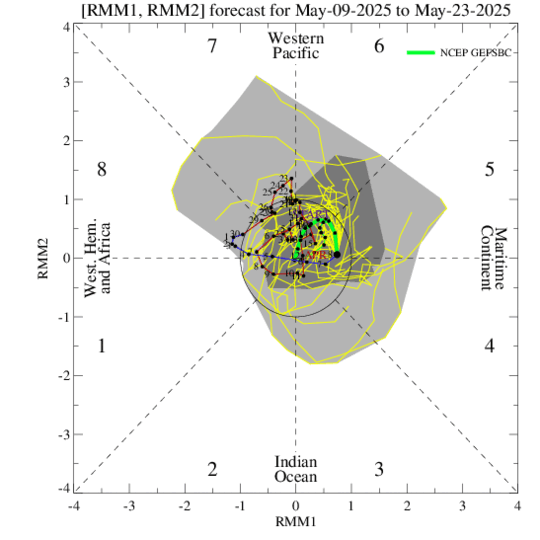
it might warm further as the forecast has the mjo lingering over the western hemisphere

Image

i predict elnino before august...
0 likes   
Remember, all of my post aren't official. For official warnings and discussions, Please refer to your local NWS products...

NWS for the Western Pacific

https://www.weather.gov/gum/

Ntxw
Storm2k Moderator
Storm2k Moderator
Posts: 21557
Joined: Wed Oct 21, 2009 6:34 pm
Location: DFW, Texas

Re: ENSO=CPC 6/18/12 update=Nino 3.4 up to +0.3C

#2182 Postby Ntxw » Mon Jun 18, 2012 11:07 am

It is interesting to note that most of June the SOI has spent way more time negative than positive. Even as the MJO/Kelvin wave having moved east, the pattern in the southern ocean still allows for good negative values to flare. I think we have transitioned (in the atmosphere) close to a El Nino regime. The eastern basin is very, very warm so even with easterlies I doubt this phenomenon will even cool. If anything it might add to the warming now that clearly an east based nino has already arrived.
0 likes   
The above post and any post by Ntxw is NOT an official forecast and should not be used as such. It is just the opinion of the poster and may or may not be backed by sound meteorological data. It is NOT endorsed by any professional institution including Storm2k. For official information, please refer to NWS products.

  Help support Storm2K!
Help Support Storm2K

User avatar
Kingarabian
S2K Supporter
S2K Supporter
Posts: 15455
Joined: Sat Aug 08, 2009 3:06 am
Location: Honolulu, Hawaii

#2183 Postby Kingarabian » Mon Jun 18, 2012 1:06 pm

I knew it would El-Nino because May was seriously hot.
0 likes   
RIP Kobe Bryant

User avatar
Kingarabian
S2K Supporter
S2K Supporter
Posts: 15455
Joined: Sat Aug 08, 2009 3:06 am
Location: Honolulu, Hawaii

#2184 Postby Kingarabian » Mon Jun 18, 2012 8:12 pm

Latest SOI dropped keeps going negative.
If the pacific keeps it up we could have El-nino in a few
0 likes   
RIP Kobe Bryant

joshb19882004
Tropical Low
Tropical Low
Posts: 23
Joined: Thu Apr 05, 2012 10:10 am

Re: ENSO=CPC 6/18/12 update=Nino 3.4 up to +0.3C

#2185 Postby joshb19882004 » Tue Jun 19, 2012 9:12 am

today soi is moderately negative
Average for last 30 days -8.1
Average for last 90 days -4.6
Daily contribution to SOI calculation -19.4
0 likes   

User avatar
cycloneye
Admin
Admin
Posts: 139504
Age: 67
Joined: Thu Oct 10, 2002 10:54 am
Location: San Juan, Puerto Rico

Re: ENSO=CPC 6/18/12 update=Nino 3.4 up to +0.3C

#2186 Postby cycloneye » Tue Jun 19, 2012 9:28 am

Neutral is still hanging barely for August,September and October in this early June update. The mid June graphic with all the ENSO Models updated will come later today or tommorow.
0 likes   
Visit the Caribbean-Central America Weather Thread where you can find at first post web cams,radars
and observations from Caribbean basin members Click Here

Ntxw
Storm2k Moderator
Storm2k Moderator
Posts: 21557
Joined: Wed Oct 21, 2009 6:34 pm
Location: DFW, Texas

Re: ENSO=CPC 6/18/12 update=Nino 3.4 up to +0.3C

#2187 Postby Ntxw » Tue Jun 19, 2012 11:34 am

Gfs and euro are predicting a monster high at darwin in several days. And it means business, we're talking -50s soi!!! Even if it partially verifies -30s are likely. More tanking continues, that will bring the 30 day crashing and set off el nino for sure.
Last edited by Ntxw on Sun Jun 24, 2012 9:59 am, edited 2 times in total.
0 likes   
The above post and any post by Ntxw is NOT an official forecast and should not be used as such. It is just the opinion of the poster and may or may not be backed by sound meteorological data. It is NOT endorsed by any professional institution including Storm2k. For official information, please refer to NWS products.


  Help support Storm2K!

Help Support Storm2K


joshb19882004
Tropical Low
Tropical Low
Posts: 23
Joined: Thu Apr 05, 2012 10:10 am

Re: ENSO=CPC 6/18/12 update=Nino 3.4 up to +0.3C

#2188 Postby joshb19882004 » Wed Jun 20, 2012 12:50 pm

another day of - soi values
SOI values for 20 Jun 2012 Average for last 30 days -8.4
Average for last 90 days -4.8
Daily contribution to SOI calculation -11.3

check the Australian climate site there nino 3.4 reads 0.4
http://www.bom.gov.au/climate/enso/
0 likes   

Ntxw
Storm2k Moderator
Storm2k Moderator
Posts: 21557
Joined: Wed Oct 21, 2009 6:34 pm
Location: DFW, Texas

Re: ENSO Updates

#2189 Postby Ntxw » Thu Jun 21, 2012 12:17 pm

Upwelling is occuring in the central and western basins. 3.4 and 4 have filled in this week. The forecasted major crash of the SOI is still in play from the dynamical models (-30s, -40s or more) soon. Pressures in Darwin will read higher than 1016mb which has not been seen since the last Nino back in 2010. Nino is on the doorstep if not already here. Another key evident is blocking in North America. Not always the case but Ninos favor lengthy -NAO features in the north Atlantic as seen much in June.

Image

Aside from ENSO notice the very cold anomalies in northern Australia. This suppresses convection around Darwin which is why SOI has held mostly negative in the month of June.

A little side note. The oncoming (strong) Nino of 1997-1998 looked like this, however it came a month sooner in May vs June. Now I do not believe we are in for that kind of a Nino (cold PDO) but the similarities can't be overlooked. The eastern basin started baking first.

Image
0 likes   
The above post and any post by Ntxw is NOT an official forecast and should not be used as such. It is just the opinion of the poster and may or may not be backed by sound meteorological data. It is NOT endorsed by any professional institution including Storm2k. For official information, please refer to NWS products.


  Help support Storm2K!

Help Support Storm2K


joshb19882004
Tropical Low
Tropical Low
Posts: 23
Joined: Thu Apr 05, 2012 10:10 am

Re: ENSO Updates

#2190 Postby joshb19882004 » Thu Jun 21, 2012 9:35 pm

wow a big plunge in the 30 soi graph
0 likes   

joshb19882004
Tropical Low
Tropical Low
Posts: 23
Joined: Thu Apr 05, 2012 10:10 am

Re: ENSO Updates

#2191 Postby joshb19882004 » Thu Jun 21, 2012 9:36 pm

0 likes   

User avatar
cycloneye
Admin
Admin
Posts: 139504
Age: 67
Joined: Thu Oct 10, 2002 10:54 am
Location: San Juan, Puerto Rico

Re: ENSO Updates

#2192 Postby cycloneye » Fri Jun 22, 2012 6:07 pm

Is immiment now the presence of El Nino as this Mid-June update of the ENSO models confirm. The only question left is when it will be officially declared and how strong it will be.

http://portal.iri.columbia.edu/portal/s ... 2&userID=2

Image
0 likes   
Visit the Caribbean-Central America Weather Thread where you can find at first post web cams,radars
and observations from Caribbean basin members Click Here

Ntxw
Storm2k Moderator
Storm2k Moderator
Posts: 21557
Joined: Wed Oct 21, 2009 6:34 pm
Location: DFW, Texas

#2193 Postby Ntxw » Sat Jun 23, 2012 10:17 pm

Convective bursts with westerlies continue to fire in ENSO 3.4 region as yet another Kelvin wave will flare up. The next few updates by CPC will be interesting to follow in regards to the Nino.
0 likes   
The above post and any post by Ntxw is NOT an official forecast and should not be used as such. It is just the opinion of the poster and may or may not be backed by sound meteorological data. It is NOT endorsed by any professional institution including Storm2k. For official information, please refer to NWS products.


  Help support Storm2K!

Help Support Storm2K


SaskatchewanScreamer

#2194 Postby SaskatchewanScreamer » Sat Jun 23, 2012 10:34 pm

In Canada and the northern US, the additional heat strengthens and alters the path of the JET STREAM - the high-altitude, fast-moving river of air that steers weather systems around the world. What happens to North American weather in the weeks following the onset of El Niño largely depends on whether the jet stream remains a single stream or splits in 2. A single jet stream curving north over BC then plunging south through the centre of the continent brings colder temperatures to the Great Lakes and eastern North America. At the same time, a high pressure system stalls over the Rocky Mountains, preventing moist Pacific air from moving inland. Mild, dry weather then dominates western Canada and the northwestern US. If the jet stream splits, its extreme northern branch tends to create storms in the Gulf of Alaska and warm temperatures in western Canada. The southern branch delivers more storms to California, Texas and Florida before moving up the east coast of North America.

It is difficult to predict what type of weather an El Niño will bring to North America, since each occurrence varies greatly in strength and impact. In the winter of 1982-83, very mild Pacific air penetrated eastward to the Great Lakes and beyond. Yet 6 years earlier, southern Ontario suffered a cold winter while the West experienced balmy temperatures during a weaker El Niño.

For people who depend on the weather for their livelihood, El Niño has both good and bad side effects. For BC salmon fishermen, it can be good news as Fraser River-bound sockeye opt for cooler waters, making them available to Canadian fishermen only. On the other hand, schools of hungry mackerel riding the El Niño wave may devour young sockeye stock. :rarrow: To Prairie farmers anxious to see soil moisture replenished ( :lol: after this year :roll: ) , El Niño's usually snow-free winter is not welcome news. On the other hand, an El Niño year also correlates with a warmer, wetter spring :larrow: :roll: , which increases spring wheat yields.

La Nina/Neutral brought us a dry winter in 2012 and the 2nd wettest spring in this province's history (and 2011 had an exceptionally wet spring too). I really don't trust what they say re what either one could bring us now.
0 likes   

joshb19882004
Tropical Low
Tropical Low
Posts: 23
Joined: Thu Apr 05, 2012 10:10 am

Re: ENSO Updates: Mid June Update of ENSO Models

#2195 Postby joshb19882004 » Sun Jun 24, 2012 8:02 am

-40s in the daily soi
Latest Southern Oscillation Index values
SOI values for 24 Jun 2012 Average for last 30 days -9.6
Average for last 90 days -5.3
Daily contribution to SOI calculation -41.2
0 likes   

User avatar
euro6208
Category 5
Category 5
Posts: 18547
Joined: Mon Mar 08, 2004 7:50 pm
Location: Guam

Re: ENSO Updates: Mid June Update of ENSO Models

#2196 Postby euro6208 » Sun Jun 24, 2012 9:34 am

Date Tahiti Darwin Daily** 30 day avg SOI 90 day avg SOI

24 Jun 2012 1011.98 1016.55 -41.19 -9.59 -5.34

wow! it went from -8.72 to -41.19!...

20120524,20120622,-8.8

at this rate, el nino might be here before the second half of july!!! :eek:
0 likes   
Remember, all of my post aren't official. For official warnings and discussions, Please refer to your local NWS products...

NWS for the Western Pacific

https://www.weather.gov/gum/

Ntxw
Storm2k Moderator
Storm2k Moderator
Posts: 21557
Joined: Wed Oct 21, 2009 6:34 pm
Location: DFW, Texas

Re: ENSO Updates: Mid June Update of ENSO Models

#2197 Postby Ntxw » Sun Jun 24, 2012 10:00 am

Was a good forecast call by the models. Darwin pressures indeed went through the roof. As big a tank today's SOI was I don't think this is the peak. Tomorrow's may go even higher if not the next day.
0 likes   
The above post and any post by Ntxw is NOT an official forecast and should not be used as such. It is just the opinion of the poster and may or may not be backed by sound meteorological data. It is NOT endorsed by any professional institution including Storm2k. For official information, please refer to NWS products.


  Help support Storm2K!

Help Support Storm2K


User avatar
cycloneye
Admin
Admin
Posts: 139504
Age: 67
Joined: Thu Oct 10, 2002 10:54 am
Location: San Juan, Puerto Rico

Re: ENSO Updates

#2198 Postby cycloneye » Sun Jun 24, 2012 10:28 am

Nice mountain forecast by CFSv2. Looks like a lovely winter for many in the U.S. :)

Image
0 likes   
Visit the Caribbean-Central America Weather Thread where you can find at first post web cams,radars
and observations from Caribbean basin members Click Here

User avatar
Kingarabian
S2K Supporter
S2K Supporter
Posts: 15455
Joined: Sat Aug 08, 2009 3:06 am
Location: Honolulu, Hawaii

#2199 Postby Kingarabian » Sun Jun 24, 2012 3:08 pm

Question: Does the CPC use the SOI values in any of it's forecasts?
0 likes   
RIP Kobe Bryant

joshb19882004
Tropical Low
Tropical Low
Posts: 23
Joined: Thu Apr 05, 2012 10:10 am

Re: ENSO Updates: SOI continues to go down (Below -8)

#2200 Postby joshb19882004 » Sun Jun 24, 2012 3:16 pm

Joe Bastardi ‏@BigJoeBastardi

SOI AT -41 lowest daily June value since 2009, next 2004 then 2002
0 likes   


Return to “Talkin' Tropics”

Who is online

Users browsing this forum: caneman, CM2, Cpv17, Stratton23, TheWisestofAll, wxman57 and 50 guests