

ENSO Updates (2007 thru 2023)
Moderator: S2k Moderators
Forum rules

The posts in this forum are NOT official forecasts and should not be used as such. They are just the opinion of the poster and may or may not be backed by sound meteorological data. They are NOT endorsed by any professional institution or STORM2K. For official information, please refer to products from the National Hurricane Center and National Weather Service.
-
cycloneye

- Admin

- Posts: 149410
- Age: 69
- Joined: Thu Oct 10, 2002 10:54 am
- Location: San Juan, Puerto Rico
Re: ENSO Updates / SOI continues on uptick
Is now 12 days in a row that the daily SOI is in positive.
http://www.longpaddock.qld.gov.au/seaso ... soivalues/
http://www.longpaddock.qld.gov.au/seaso ... soivalues/
0 likes
Visit the Caribbean-Central America Weather Thread where you can find at first post web cams,radars
and observations from Caribbean basin members Click Here
and observations from Caribbean basin members Click Here
-
Blown Away

- S2K Supporter

- Posts: 10253
- Joined: Wed May 26, 2004 6:17 am
Re: ENSO Updates / SOI continues on uptick
Ok, if 90 day SOI average has to be below the -8.00 threshold to declare El Nino, it seems that the chances of that occurring before September 10th appear low considering we are nearing the end of July?? So neutral conditions may be in place during the heart of the season??
I'm sure there is a flaw in my thinking!
Also, I looked back at all El Nino SOI graphs back to 1991, 1991 and 2009 were the only years that had a 30 day SOI average near -4 near July 19th, the rest of the El Nino years since 1991 were lower than -12.
I'm sure there is a flaw in my thinking!
Also, I looked back at all El Nino SOI graphs back to 1991, 1991 and 2009 were the only years that had a 30 day SOI average near -4 near July 19th, the rest of the El Nino years since 1991 were lower than -12.
0 likes
Hurricane Eye Experience: David 79, Irene 99, Frances 04, Jeanne 04, Wilma 05… Hurricane Brush Experience: Andrew 92, Erin 95, Floyd 99, Matthew 16, Irma 17, Ian 22, Nicole 22…


Re: ENSO Updates / SOI continues on uptick
Certainly the longer than expected positive SOI's continue. Despite that though compared to last week at this time Nino 4 SST anomalies did manage some warming while the other regions appears to have held steady (3 may have lost a bit of steam).
Thursday July 12th

Thursday July 19th

Thursday July 12th
Thursday July 19th
0 likes
The above post and any post by Ntxw is NOT an official forecast and should not be used as such. It is just the opinion of the poster and may or may not be backed by sound meteorological data. It is NOT endorsed by any professional institution including Storm2k. For official information, please refer to NWS products.
Help support Storm2K!
-
Kingarabian

- S2K Supporter
- Posts: 16355
- Joined: Sat Aug 08, 2009 3:06 am
- Location: Honolulu, Hawaii

Re: ENSO Updates / SOI continues on uptick
Ntxw wrote:Certainly the longer than expected positive SOI's continue. Despite that though compared to last week at this time Nino 4 SST anomalies did manage some warming while the other regions appears to have held steady (3 may have lost a bit of steam).
Thursday July 12th
http://i48.tinypic.com/157fytk.gif
Thursday July 19th
http://i47.tinypic.com/2lj3lt1.gif
Yes, it has warmed up again during this week, I will not be surprised if next week's weekly update is raised back up to at last .5 deg C above average for Nino 3.4
0 likes
-
cycloneye
- Admin
- Posts: 149410
- Age: 69
- Joined: Thu Oct 10, 2002 10:54 am
- Location: San Juan, Puerto Rico
Re: ENSO Updates / SOI continues on uptick
Here is a 4 month loop of the Pacific and see how it has warmed thru July 19th with the slowing of the warmup at the last frames. We have to see if the slight warming in the last three days is sustained for the next two weeks to then be more confident on El Nino comming. But that SOI uptick doesn't want to stop for now.

0 likes
Visit the Caribbean-Central America Weather Thread where you can find at first post web cams,radars
and observations from Caribbean basin members Click Here
and observations from Caribbean basin members Click Here
-
cycloneye
- Admin
- Posts: 149410
- Age: 69
- Joined: Thu Oct 10, 2002 10:54 am
- Location: San Juan, Puerto Rico
Re: ENSO Updates / SOI continues on uptick
On July 19,1997 the Pacific was already with a Strong El Nino. Is not even close what is going on in 2012 with a warm Neutral status but close to El Nino being declared officially. (A weak one)
July 19 1997
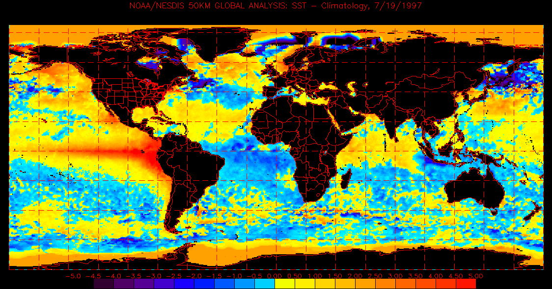
July 19 2012

July 19 1997
July 19 2012
0 likes
Visit the Caribbean-Central America Weather Thread where you can find at first post web cams,radars
and observations from Caribbean basin members Click Here
and observations from Caribbean basin members Click Here
-
Blown Away
- S2K Supporter
- Posts: 10253
- Joined: Wed May 26, 2004 6:17 am
Re: ENSO Updates / SOI continues on uptick
Up again Friday.
0 likes
Hurricane Eye Experience: David 79, Irene 99, Frances 04, Jeanne 04, Wilma 05… Hurricane Brush Experience: Andrew 92, Erin 95, Floyd 99, Matthew 16, Irma 17, Ian 22, Nicole 22…
-
euro6208
Re: ENSO Updates / SOI continues on uptick
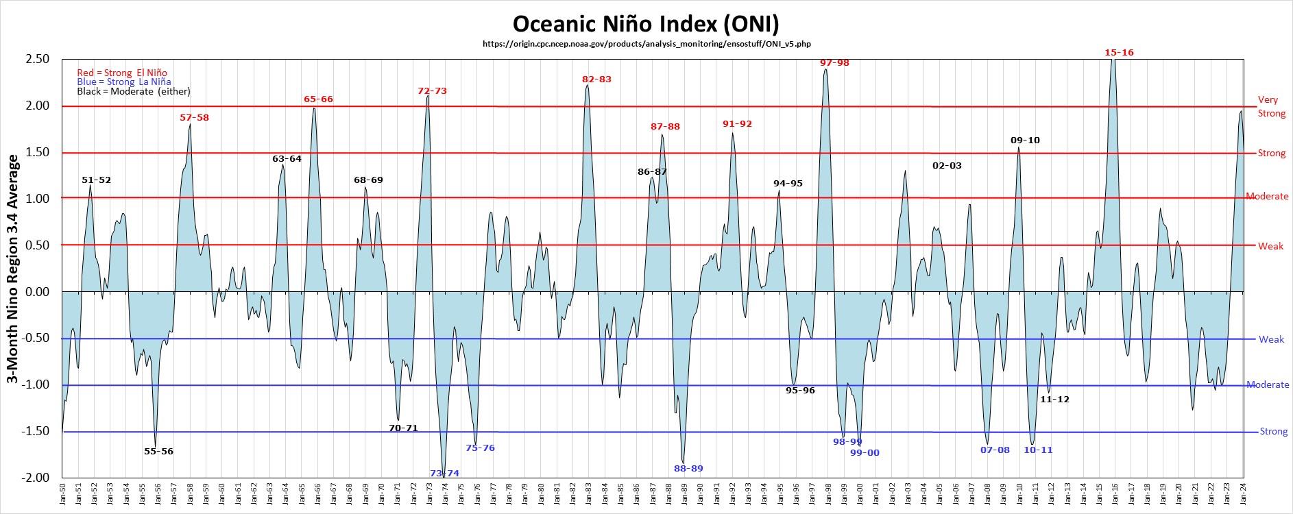
i know el nino seasons after 1997 are weaker but is 1997 our last super strong el nino?
0 likes
Re: ENSO Updates / SOI continues on uptick
euro6208 wrote:i know el nino seasons after 1997 are weaker but is 1997 our last super strong el nino?
That is correct. There have only been a handful of major Ninos above the 2c anomaly. 72-73, 82-83, and 97-98 are the three since 1950. 57-58 and 65-66 came very close.
0 likes
The above post and any post by Ntxw is NOT an official forecast and should not be used as such. It is just the opinion of the poster and may or may not be backed by sound meteorological data. It is NOT endorsed by any professional institution including Storm2k. For official information, please refer to NWS products.
Help support Storm2K!
Help support Storm2K!
-
cycloneye
- Admin
- Posts: 149410
- Age: 69
- Joined: Thu Oct 10, 2002 10:54 am
- Location: San Juan, Puerto Rico
Re: ENSO Updates / SOI continues on uptick
Mid-July ENSO Models forecast
The majority of them are at weak El Nino by August, September and October period. The Graphic plume of models is below the text of discussion.
Technical ENSO Update
19 July 2012
Recent and Current Conditions
After a period of neutral ENSO conditions between May and late June 2012, SST anomalies in the east-central tropical Pacific became sufficiently positive to be at a borderline El Niño level. SST anomalies are largest in the eastern portion of the NINO3.4 region, and weaker toward the dateline. For June the SST anomaly in the NINO3.4 was 0.31 C, indicative of above-average but neutral ENSO conditions. For March-May the anomaly was -0.04 C. Since December 2011, the IRI's definition of El Niño conditions began following that of NOAA/Climate Prediction Center, in which the SST anomaly in the NINO3.4 region (5S-5N; 170W-120W) exceeds 0.45 C. Similarly, for La Niña, the anomaly must be -0.45 C or less. The climatological probabilities for La Niña, neutral, and El Niño conditions vary seasonally, and are shown in a table at the bottom of this page for each 3-month season. The most recent weekly SST anomaly in the NINO3.4 region is 0.4 C, indicating near-borderline El Niño conditions in the tropical Pacific; although this is slightly warmer than the -0.05 C level observed in May, it has cooled slightly from anomalies of 0.5 and 0.6 observed during the previous week and the week before that, respectively.
Expected Conditions
What is the outlook for the ENSO status going forward? The official diagnosis and outlook was issued earlier this month in the NOAA/Climate Prediction Center ENSO Diagnostic Discussion, produced jointly by CPC and IRI. It carried an El Niño watch, and gave a probability of 55% for El Niño conditions developing most likely during the July-September period. Now, in the middle of July, a new set of model ENSO predictions is available as shown in the IRI/CPC ENSO prediction plume, discussed below. The current east-central tropical Pacific SSTs are at a borderline El Niño level, and the basin-wide sea level pressure pattern has also been in the direction of El Niño, although not as clearly as the SST. Low-level zonal winds and anomalous convection have been near average and have not yet swung toward an El Niño state with consistency. Subsurface temperatures across the equatorial Pacific have risen to become moderately above average in the upper part of the ocean from just east of the date line eastward to 90W, and also in the western Pacific to a lesser extent. A relative weakness in the subsurface warmth is found near the dateline. The thermocline depth along the equator is above average in the western and eastern tropical Pacific, but not in the central one-third of the basin. where the thermocline is just slightly shallower than average.
http://portal.iri.columbia.edu/portal/s ... 2&userID=2
0 likes
Visit the Caribbean-Central America Weather Thread where you can find at first post web cams,radars
and observations from Caribbean basin members Click Here
and observations from Caribbean basin members Click Here
-
cycloneye
- Admin
- Posts: 149410
- Age: 69
- Joined: Thu Oct 10, 2002 10:54 am
- Location: San Juan, Puerto Rico
Re: ENSO Updates / SOI continues on uptick
Blown Away wrote:Up again Friday.
And up on Saturday. (14 in a row)
0 likes
Visit the Caribbean-Central America Weather Thread where you can find at first post web cams,radars
and observations from Caribbean basin members Click Here
and observations from Caribbean basin members Click Here
Re: ENSO:Majority of Models (Weak El Nino on ASO) / SOI up
Per models, I'm projecting the +SOI string to finally be broken tomorrow, with modest -'s on 7/22-3. 7/24 should rise back to near neutral followed by fairly modest +'s 7/25-7. Then expect
-'s for 7/28-31, with some strong negatives (maybe sub -30 one or two days). This means that the 30 day would rise to ~-2 on 7/24 and near 0 on 7/25. The 30 day would then go to ~+2 on 7/26 and ~+3 for 7/27-8. Then it would fall back toward 0. I'm projecting July as a whole to end up in the 0 to +1 range.
-'s for 7/28-31, with some strong negatives (maybe sub -30 one or two days). This means that the 30 day would rise to ~-2 on 7/24 and near 0 on 7/25. The 30 day would then go to ~+2 on 7/26 and ~+3 for 7/27-8. Then it would fall back toward 0. I'm projecting July as a whole to end up in the 0 to +1 range.
0 likes
Personal Forecast Disclaimer:
The posts in this forum are NOT official forecasts and should not be used as such. They are just the opinion of the poster and may or may not be backed by sound meteorological data. They are NOT endorsed by any professional institution or storm2k.org. For official information, please refer to the NHC and NWS products.
The posts in this forum are NOT official forecasts and should not be used as such. They are just the opinion of the poster and may or may not be backed by sound meteorological data. They are NOT endorsed by any professional institution or storm2k.org. For official information, please refer to the NHC and NWS products.
-
euro6208
Re: ENSO:Majority of Models (Weak El Nino on ASO) / SOI up
looks like the mjo is trying to buildup over the pacific, if that happens, then we might see some major changes

0 likes
Re: ENSO:Majority of Models (Weak El Nino on ASO) / SOI up
euro6208 wrote:looks like the mjo is trying to buildup over the pacific, if that happens, then we might see some major changes
Indeed there are signs a significant Kelvin wave may arise near the dateline in the coming near future. Will this be the catalyst for persistent convection? We'll know soon.
0 likes
The above post and any post by Ntxw is NOT an official forecast and should not be used as such. It is just the opinion of the poster and may or may not be backed by sound meteorological data. It is NOT endorsed by any professional institution including Storm2k. For official information, please refer to NWS products.
Help support Storm2K!
Help support Storm2K!
-
cycloneye
- Admin
- Posts: 149410
- Age: 69
- Joined: Thu Oct 10, 2002 10:54 am
- Location: San Juan, Puerto Rico
Re: ENSO:Majority of Models (Weak El Nino on ASO)
The uptick streak of the daily SOI is over after 14 days as it went negative on Sunday.
http://www.longpaddock.qld.gov.au/seaso ... soivalues/
http://www.longpaddock.qld.gov.au/seaso ... soivalues/
0 likes
Visit the Caribbean-Central America Weather Thread where you can find at first post web cams,radars
and observations from Caribbean basin members Click Here
and observations from Caribbean basin members Click Here
-
cycloneye
- Admin
- Posts: 149410
- Age: 69
- Joined: Thu Oct 10, 2002 10:54 am
- Location: San Juan, Puerto Rico
Re: ENSO:Majority of Models (Weak El Nino on ASO)
Here is a good site where the members who may not know how many times and when a Strong,Moderate and Weak El Nino occured can see the information .Same goes with La Nina. The big question is when El Nino comes at some point in the next few weeks how strong it will be?
http://ggweather.com/enso/oni.htm
http://ggweather.com/enso/oni.htm
0 likes
Visit the Caribbean-Central America Weather Thread where you can find at first post web cams,radars
and observations from Caribbean basin members Click Here
and observations from Caribbean basin members Click Here
-
South Texas Storms

- Professional-Met

- Posts: 4257
- Joined: Thu Jun 24, 2010 12:28 am
- Location: Houston, TX
Re: ENSO:Majority of Models (Weak El Nino on ASO) / SOI up
Ntxw wrote:euro6208 wrote:looks like the mjo is trying to buildup over the pacific, if that happens, then we might see some major changes
Indeed there are signs a significant Kelvin wave may arise near the dateline in the coming near future. Will this be the catalyst for persistent convection? We'll know soon.
Would this mean that the EPAC waters would warm?
0 likes
Re: ENSO:Majority of Models (Weak El Nino on ASO) / SOI up
South Texas Storms wrote:Would this mean that the EPAC waters would warm?
I'm not sure EPAC waters would warm much more as it's already very warm. A dateline Kelvin wave would support further warming of ENSO 3.4 and 4. This has more implications on the central and WPAC basin. The true sub-surface warm anomalies have yet to make the presence in those regions which is why upwelling would warm that region quickest.
http://www.cpc.ncep.noaa.gov...enso_update/wkxzteq.shtml
However there's no guaranty this will happen. The MJO is still inactive and disorganized. Forecasting it has proven to be tough.
0 likes
The above post and any post by Ntxw is NOT an official forecast and should not be used as such. It is just the opinion of the poster and may or may not be backed by sound meteorological data. It is NOT endorsed by any professional institution including Storm2k. For official information, please refer to NWS products.
Help support Storm2K!
Help support Storm2K!
Who is online
Users browsing this forum: No registered users and 75 guests