

rainstorm wrote:SOI continues to be positive. maybe the el nino has peaked.
Enso does not peak until southern hemisphere Spring or Summer.
Moderator: S2k Moderators

rainstorm wrote:SOI continues to be positive. maybe the el nino has peaked.


NDG wrote:No wonder there is no comparison to 2009, that the Atlantic has been more active than that year.
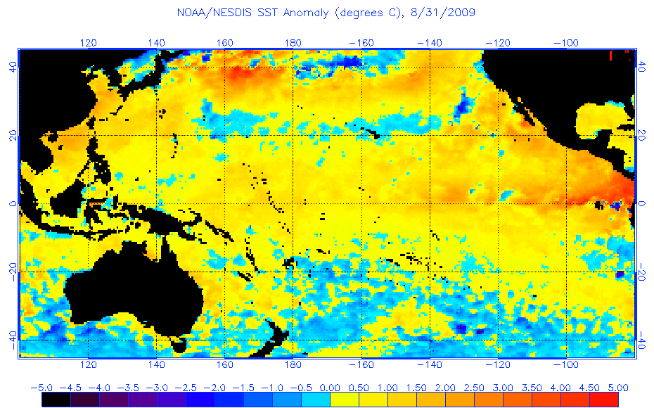
Modoki anyone, look how warmer the eastern Pacific was for the same time compared to this year.
.


Ntxw wrote:NDG wrote:No wonder there is no comparison to 2009, that the Atlantic has been more active than that year.
Modoki anyone, look how warmer the eastern Pacific was for the same time compared to this year.
.
You're right there is no comparison to 2009. That year featured Bill a cat 4 by now and another major in early Sept Fred.


Ntxw wrote:It's a bit early to tell South Texas Storms today, Sunday will give a better idea. Eastern Nino regions have recovered a bit this week and moving into the 3.4 areas with a big burst of warming so I'm guessing a warm up in Monday's update if it persist maybe even a lot since last week. Here is loop for daily's.
http://www.esrl.noaa.gov/psd/map/clim/s ... .week.html
Nino 3.4 is between 170 and 120W
South Texas Storms wrote:Thanks for posting that link showing the loop of the daily's! I can clearly see the warming across Nino 3.4 over the past several days now. I'm surprised at this because the MJO isn't favorable for warming and the SOI's show no sign of tanking for at least the next 5 days. Are you surprised that the big burst of warming is occuring right now?
Ntxw wrote:South Texas Storms wrote:Thanks for posting that link showing the loop of the daily's! I can clearly see the warming across Nino 3.4 over the past several days now. I'm surprised at this because the MJO isn't favorable for warming and the SOI's show no sign of tanking for at least the next 5 days. Are you surprised that the big burst of warming is occuring right now?
Sub-surface temps suggest constant slow warming until peak (probably OND or NDJ). Central based Ninos are most susceptible to short term MJO influence unlike EP Ninos. An unfavorable MJO phase works to hold off the warming a bit but when it's no longer unfavorable, warming resumes. MJO currently isn't unfavorable nor favorable. This is why we've seen ups and downs but overall it does not effect too much in the grand scheme. It also explains SOI being up and down but the nino anomalies have pretty much held over 0.5c despite days of positives. MJO noise.
Users browsing this forum: gib and 234 guests

