

ENSO Updates (2007 thru 2023)
Moderator: S2k Moderators
Forum rules

The posts in this forum are NOT official forecasts and should not be used as such. They are just the opinion of the poster and may or may not be backed by sound meteorological data. They are NOT endorsed by any professional institution or STORM2K. For official information, please refer to products from the National Hurricane Center and National Weather Service.
Re: ENSO Updates
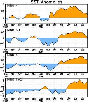
As I thought, looks like on today's CPC ENSO update, Nino 3.4 will be dropped to 0 deg C, dead on neutral.
0 likes
-
cycloneye

- Admin

- Posts: 149550
- Age: 69
- Joined: Thu Oct 10, 2002 10:54 am
- Location: San Juan, Puerto Rico
Re: ENSO Updates
NDG wrote:As I thought, looks like on today's CPC ENSO update, Nino 3.4 will be dropped to 0 deg C, dead on neutral.
http://i20.photobucket.com/albums/b245/ ... 0c58ab.gif
Can you post the link to that graphic? I lost it.
0 likes
Visit the Caribbean-Central America Weather Thread where you can find at first post web cams,radars
and observations from Caribbean basin members Click Here
and observations from Caribbean basin members Click Here


Per the weekly anom index 3.4 actually is down to -0.1C. All other regions fell as well except for 1.2 which rose a notch.
0 likes
The above post and any post by Ntxw is NOT an official forecast and should not be used as such. It is just the opinion of the poster and may or may not be backed by sound meteorological data. It is NOT endorsed by any professional institution including Storm2k. For official information, please refer to NWS products.
Help support Storm2K!
Re: ENSO Updates
cycloneye wrote:NDG wrote:As I thought, looks like on today's CPC ENSO update, Nino 3.4 will be dropped to 0 deg C, dead on neutral.
http://i20.photobucket.com/albums/b245/ ... 0c58ab.gif
Can you post the link to that graphic? I lost it.
http://www.cpc.ncep.noaa.gov/products/a ... ssta_c.gif
0 likes
 Wow, so more than what the graphic shows.
-
cycloneye
- Admin
- Posts: 149550
- Age: 69
- Joined: Thu Oct 10, 2002 10:54 am
- Location: San Juan, Puerto Rico
Re: ENSO: CPC 7/28/14=Nino 3.4 down to -0.1C
The weekly text by CPC confirms the dip to -0.1C.
http://www.cpc.ncep.noaa.gov/products/a ... ts-web.pdf
http://www.cpc.ncep.noaa.gov/products/a ... ts-web.pdf
0 likes
Visit the Caribbean-Central America Weather Thread where you can find at first post web cams,radars
and observations from Caribbean basin members Click Here
and observations from Caribbean basin members Click Here
Re: ENSO: CPC 7/28/14=Nino 3.4 down to -0.1C
0 likes

-
cycloneye
- Admin
- Posts: 149550
- Age: 69
- Joined: Thu Oct 10, 2002 10:54 am
- Location: San Juan, Puerto Rico
Re: ENSO: CPC 7/28/14=Nino 3.4 down to -0.1C
Australian update of 7/29/14
They went down in the % to 50.
El Niño indicators ease
Issued on Tuesday 29 July 2014 | Product Code IDCKGEWW00
Despite the tropical Pacific Ocean being primed for an El Niño during much of the first half of 2014, the atmosphere above has largely failed to respond, and hence the ocean and atmosphere have not reinforced each other. As a result, some cooling has now taken place in the central and eastern tropical Pacific Ocean, with most of the key NINO regions returning to neutral values.
While the chance of an El Niño in 2014 has clearly eased, warmer-than-average waters persist in parts of the tropical Pacific, and the (slight) majority of climate models suggest El Niño remains likely for spring. Hence the establishment of El Niño before year's end cannot be ruled out. If an El Niño were to occur, it is increasingly unlikely to be a strong event.
Given the current observations and the climate model outlooks, the Bureau’s ENSO Tracker has shifted to El Niño WATCH status. This means the chance of El Niño developing in 2014 is approximately 50%, which remains significant at double the normal likelihood of an event.
http://www.bom.gov.au/climate/enso/
0 likes
Visit the Caribbean-Central America Weather Thread where you can find at first post web cams,radars
and observations from Caribbean basin members Click Here
and observations from Caribbean basin members Click Here
Re: ENSO: BoM 7/29/14: El Nino indicators ease
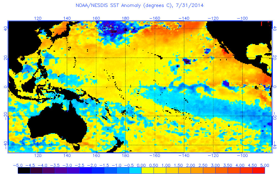
Looks like this new down-welling Oceanic Kelvin wave is the real deal. A new warm pool is likely in the making below the surface, this is where 2012 failed into August/September. 1+2 will likely feel dramatic cooling with the cool pool in the east being pushed up and out by this new OKW. Lets see if these anomalies continues to grow.

0 likes
The above post and any post by Ntxw is NOT an official forecast and should not be used as such. It is just the opinion of the poster and may or may not be backed by sound meteorological data. It is NOT endorsed by any professional institution including Storm2k. For official information, please refer to NWS products.
Help support Storm2K!
Help support Storm2K!
-
cycloneye
- Admin
- Posts: 149550
- Age: 69
- Joined: Thu Oct 10, 2002 10:54 am
- Location: San Juan, Puerto Rico
Re: ENSO: BoM 7/29/14: El Nino indicators ease
Ntxw If that cold pool goes up at 1+2 ,then it may be Modoki?
0 likes
Visit the Caribbean-Central America Weather Thread where you can find at first post web cams,radars
and observations from Caribbean basin members Click Here
and observations from Caribbean basin members Click Here
Re: ENSO: BoM 7/29/14: El Nino indicators ease
cycloneye wrote:Ntxw If that cold pool goes up at 1+2 ,then it may be Modoki?
It may, the caveat is 3.4 has been stubborn to warm. You will need 1+2 to be cooler than 3.4, perhaps later into the fall.
0 likes
The above post and any post by Ntxw is NOT an official forecast and should not be used as such. It is just the opinion of the poster and may or may not be backed by sound meteorological data. It is NOT endorsed by any professional institution including Storm2k. For official information, please refer to NWS products.
Help support Storm2K!
Help support Storm2K!
-
CaliforniaResident
- Tropical Storm

- Posts: 215
- Joined: Fri Feb 21, 2014 1:47 pm
Re: ENSO: BoM 7/29/14: El Nino indicators ease
Here in Southern California, we are seeing a very El Ninoish summer (classic and not Modoki) which has distinct characteristics you would NOT find in a typical summer. I am still calling for a moderate El Nino to materialize in fall. Nino 1+2 is still quite "Ninoish" and the latest Kelvin Wave could bring warming to other regions.
0 likes
-
Yellow Evan

- Professional-Met

- Posts: 16242
- Age: 27
- Joined: Fri Jul 15, 2011 12:48 pm
- Location: Henderson, Nevada/Honolulu, HI
- Contact:
Re: ENSO: BoM 7/29/14: El Nino indicators ease
CaliforniaResident wrote:Here in Southern California, we are seeing a very El Ninoish summer (classic and not Modoki) which has distinct characteristics you would NOT find in a typical summer.
Which are?
0 likes

-
euro6208
Re: ENSO: BoM 7/29/14: El Nino indicators ease
Very frustrating and disappointing pre-el nino.
0 likes

Re: ENSO: BoM 7/29/14: El Nino indicators ease
That large cool pool that has been present much of the year to the south of the equator looks like it is shrinking with time, is it possible this is mixing cooler waters and contributing to the stalling El Nino for the time being, and with it shrinking could that be an indication that things will pick back up in a few months?
0 likes
The above post is not official and should not be used as such. It is the opinion of the poster and may or may not be backed by sound meteorological data. It is not endorsed by any professional institution or storm2k.org. For official information, please refer to the NHC and NWS products.
-
xtyphooncyclonex

- Category 5

- Posts: 3892
- Age: 24
- Joined: Sat Dec 08, 2012 9:07 am
- Location: Cebu City
- Contact:
Re: ENSO: BoM 7/29/14: El Nino indicators ease
euro6208 wrote:Very frustrating and disappointing pre-el nino.
You should know that there is a cool pool pushed to the surface as an even bigger warmer pool is developing beneath the equatorial Pacific.
0 likes
REMINDER: My opinions that I, or any other NON Pro-Met in this forum, are unofficial. Please do not take my opinions as an official forecast and warning. I am NOT a meteorologist. Following my forecasts blindly may lead to false alarm, danger and risk if official forecasts from agencies are ignored.
Who is online
Users browsing this forum: Blown Away and 76 guests