@MJVentrice
Keep an eye on the Atlantic's Main Development Region during the first few days of September. A number of ECMWF EPS members are indicating risk for a strong African easterly wave to emerge off Africa and develop into a tropical cyclone. First sign of life I've seen in awhile.
https://twitter.com/MJVentrice/status/1032044304485761024
2018 Tropics: Global Model Runs Discussion (Out to day 16)
Moderator: S2k Moderators
Forum rules

The posts in this forum are NOT official forecasts and should not be used as such. They are just the opinion of the poster and may or may not be backed by sound meteorological data. They are NOT endorsed by any professional institution or STORM2K. For official information, please refer to products from the National Hurricane Center and National Weather Service.
-
cycloneye

- Admin

- Posts: 139067
- Age: 67
- Joined: Thu Oct 10, 2002 10:54 am
- Location: San Juan, Puerto Rico
Re: 2018 Tropics: Global Model Runs Discussion (Out to day 16)
1 likes
Visit the Caribbean-Central America Weather Thread where you can find at first post web cams,radars
and observations from Caribbean basin members Click Here
and observations from Caribbean basin members Click Here
-
shiny-pebble
- Category 1

- Posts: 299
- Joined: Thu Jul 05, 2018 1:38 pm
Re: 2018 Tropics: Global Model Runs Discussion (Out to day 16)
GFS showing ~4 weak phantom storms. At the moment, really justs means conditions will be somewhat favorable.
Sent from my LG-H700 using Tapatalk
Sent from my LG-H700 using Tapatalk
0 likes
Not an meteorologist! Just someone who is interested in weather. Please refer to the NHC and local weather officials to make decisions.
-Jack
-Jack
-
storminabox
- Category 1
- Posts: 260
- Joined: Sun Jul 09, 2017 10:50 pm
Re: 2018 Tropics: Global Model Runs Discussion (Out to day 16)
I have a feeling that once Lane is all said and done in the pacific, we will see the Atlantic begin to ramp up rather dramatically. The models seem to support that happening.
9 likes

Re: 2018 Tropics: Global Model Runs Discussion (Out to day 16)
GFS looks less favorable this run for multiple storms, the few low pressures that were there are much weaker so far out to 240 hours. But the low off Africa does look a bit stronger.
Edit: GFS shows only a weak system on the latest run out to 300 hours, but the frequency of runs showing activity (as well as the number they show) is going up at an unsteady rate.
Edit: GFS shows only a weak system on the latest run out to 300 hours, but the frequency of runs showing activity (as well as the number they show) is going up at an unsteady rate.
0 likes
The above post is not official and should not be used as such. It is the opinion of the poster and may or may not be backed by sound meteorological data. It is not endorsed by any professional institution or storm2k.org. For official information, please refer to the NHC and NWS products.
-
shiny-pebble
- Category 1
- Posts: 299
- Joined: Thu Jul 05, 2018 1:38 pm
Re: 2018 Tropics: Global Model Runs Discussion (Out to day 16)
GFS is awakening. Near the end of the run it has a CV tropical storm and a storm in the EPAC which dissiaptes over land but the remnants regenerate in the Gulf.
Sent from my LG-H700 using Tapatalk
Sent from my LG-H700 using Tapatalk
0 likes
Not an meteorologist! Just someone who is interested in weather. Please refer to the NHC and local weather officials to make decisions.
-Jack
-Jack

Re: 2018 Tropics: Global Model Runs Discussion (Out to day 16)
Joe Bastardi
@BigJoeBastardi
More
Big changes in Atlantic SLP pattern indicate to me we are going to have a hurricane season this year, though as per pre season ideas, still below normal, But look at these 4 day increments and you can see a more active period is on the way with African wave train waking up
https://twitter.com/BigJoeBastardi/status/1032224094027169793
5 likes
-
gatorcane

- S2K Supporter

- Posts: 23499
- Age: 46
- Joined: Sun Mar 13, 2005 3:54 pm
- Location: Boca Raton, FL
Re: 2018 Tropics: Global Model Runs Discussion (Out to day 16)
NDG wrote:Joe Bastardi
@BigJoeBastardi
More
Big changes in Atlantic SLP pattern indicate to me we are going to have a hurricane season this year, though as per pre season ideas, still below normal, But look at these 4 day increments and you can see a more active period is on the way with African wave train waking up
https://twitter.com/BigJoeBastardi/stat ... 4027169793
Yeah I mentioned this last week and the timeframe of when these lower MSLPs is coming in. Looks like end of month is when we start to see them in the MDR which should coincide with an uptick in convection and possibly genesis:
0 likes
Re: 2018 Tropics: Global Model Runs Discussion (Out to day 16)
Interesting trend by the CFS forecast for next month showing lowers MSLPs across the MDR and off of SE US along with lower windshear trend.


1 likes
-
Ivanhater

- Storm2k Moderator

- Posts: 10852
- Age: 37
- Joined: Fri Jul 01, 2005 8:25 am
- Location: Pensacola
Re: 2018 Tropics: Global Model Runs Discussion (Out to day 16)
006Z GFS shows a tropical storm in the gulf in the long range. At the very least, the models are waking up and showing a favorable pattern
0 likes
Michael
-
gatorcane
- S2K Supporter
- Posts: 23499
- Age: 46
- Joined: Sun Mar 13, 2005 3:54 pm
- Location: Boca Raton, FL
Re: 2018 Tropics: Global Model Runs Discussion (Out to day 16)
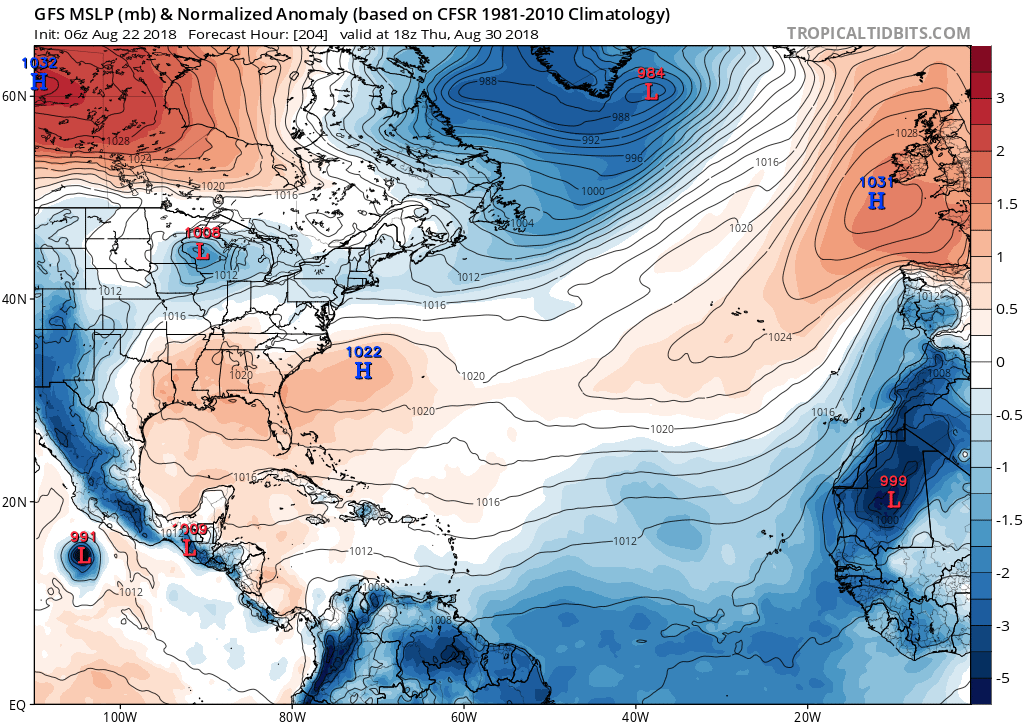
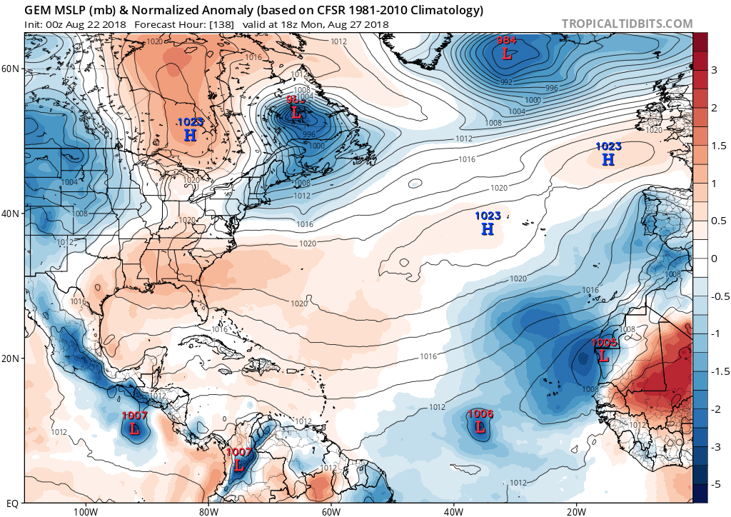
12Z CMC with Cape Verde development in 4-5 days (edit: not saying that will happen it is the CMC after all but the idea is global models are detecting that conditions gradually are becoming more favorable):
0 likes
Re: 2018 Tropics: Global Model Runs Discussion (Out to day 16)
LarryWx wrote:gatorcane wrote:12Z ECMWF with a strong area of low pressure near the Cabo Verde islands at 240 hours:
Consistent with the 12Z Euro operational, about 20% of the 50 EPS (~10) members have a TC form in the far E MDR ~Sept. 1 moving W to WNW. 4 of those 10 geneses go down to sub 990 mb (i.e., likely hurricanes). By day 15 (9/5), the TCs are mainly between 40W and 50W with some safely recurving N of 20N while others are still between 15N and 20N moving mainly WNW. None of these were on the 0Z EPS.
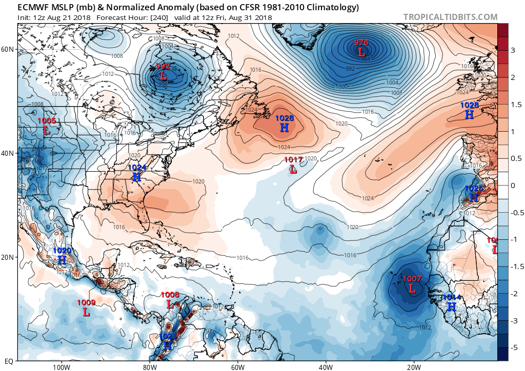
The above referenced more active 12Z EPS had gotten my and others’ attention and got Maue and Ventrice to tweet. However, today’s 0Z EPS then had significantly less activity regarding the potential Sept. 1 far E MDR system than what yesterday’s 12Z EPS had. Let’s see what today’s 12Z Euro/EPS shows.
0 likes
Personal Forecast Disclaimer:
The posts in this forum are NOT official forecasts and should not be used as such. They are just the opinion of the poster and may or may not be backed by sound meteorological data. They are NOT endorsed by any professional institution or storm2k.org. For official information, please refer to the NHC and NWS products.
The posts in this forum are NOT official forecasts and should not be used as such. They are just the opinion of the poster and may or may not be backed by sound meteorological data. They are NOT endorsed by any professional institution or storm2k.org. For official information, please refer to the NHC and NWS products.

Re: 2018 Tropics: Global Model Runs Discussion (Out to day 16)
NDG wrote:Interesting trend by the CFS forecast for next month showing lowers MSLPs across the MDR and off of SE US along with lower windshear trend.
Is it just me or is the Bermuda High weaker and displaced further NE?
0 likes
Personal Forecast Disclaimer:
The posts in this forum are NOT official forecast and should not be used as such. They are just the opinion of the poster and may or may not be backed by sound meteorological data. They are NOT endorsed by any professional institution or storm2k.org. For official information, please refer to the NHC and NWS products.
The posts in this forum are NOT official forecast and should not be used as such. They are just the opinion of the poster and may or may not be backed by sound meteorological data. They are NOT endorsed by any professional institution or storm2k.org. For official information, please refer to the NHC and NWS products.

Re: 2018 Tropics: Global Model Runs Discussion (Out to day 16)
Ivanhater wrote:006Z GFS shows a tropical storm in the gulf in the long range. At the very least, the models are waking up and showing a favorable pattern
that Gulf system is an EPAC system that crosses over. May not be Florence
0 likes
-
gatorcane
- S2K Supporter
- Posts: 23499
- Age: 46
- Joined: Sun Mar 13, 2005 3:54 pm
- Location: Boca Raton, FL
Re: 2018 Tropics: Global Model Runs Discussion (Out to day 16)
Back to crickets on the 12Z GFS through Labor Day. The model continues to show more EPAC development though.
1 likes
-
TheStormExpert

- Category 5

- Posts: 8487
- Age: 30
- Joined: Wed Feb 16, 2011 5:38 pm
- Location: Palm Beach Gardens, FL
Re: 2018 Tropics: Global Model Runs Discussion (Out to day 16)
By the time something legitimate shows up on all the models it’ll be Thanksgiving! 
1 likes
The following post is NOT an official forecast and should not be used as such. It is just the opinion of the poster and may or may not be backed by sound meteorological data. It is NOT endorsed by storm2k.org.
Re: 2018 Tropics: Global Model Runs Discussion (Out to day 16)
Euro back to no indication of anything imminent in the next ten days and beyond. It almost looks like the waves are continuing to come off much further north than normal, and the runs showing development have them coming off further south and then trending north.
1 likes
The above post is not official and should not be used as such. It is the opinion of the poster and may or may not be backed by sound meteorological data. It is not endorsed by any professional institution or storm2k.org. For official information, please refer to the NHC and NWS products.
-
TheStormExpert
- Category 5
- Posts: 8487
- Age: 30
- Joined: Wed Feb 16, 2011 5:38 pm
- Location: Palm Beach Gardens, FL
Re: 2018 Tropics: Global Model Runs Discussion (Out to day 16)
Hammy wrote:Euro back to no indication of anything imminent in the next ten days and beyond. It almost looks like the waves are continuing to come off much further north than normal, and the runs showing development have them coming off further south and then trending north.
That’s what I’ve been noticing for the past month or so is that these tropical waves are coming off the west coast of Africa at about 15N or higher straight into the stable cool atmosphere that’s in place. If they were coming off below 15N and staying at a lower latitude until about 50-60W than start gaining latitude then they may have a chance.
1 likes
The following post is NOT an official forecast and should not be used as such. It is just the opinion of the poster and may or may not be backed by sound meteorological data. It is NOT endorsed by storm2k.org.
Re: 2018 Tropics: Global Model Runs Discussion (Out to day 16)
Hammy wrote:Euro back to no indication of anything imminent in the next ten days and beyond. It almost looks like the waves are continuing to come off much further north than normal, and the runs showing development have them coming off further south and then trending north.
I'm not so sure about that, check out Day 10 (sep 1st) over the Bahamas.
0 likes
-
Stormcenter
- S2K Supporter
- Posts: 6617
- Joined: Wed Sep 03, 2003 11:27 am
- Location: Houston, TX
Re: 2018 Tropics: Global Model Runs Discussion (Out to day 16)
We all know it's inevitable that something is going to eventually threaten the U.S. main land in Sept. 2018
It's only a matter of when and where. IMO
It's only a matter of when and where. IMO
0 likes
-
stormlover2013
- Category 5
- Posts: 2312
- Joined: Thu Aug 22, 2013 12:06 pm
- Location: Lumberton, Texas
Who is online
Users browsing this forum: No registered users and 198 guests