Continuing GOM Watch

This is the general tropical discussion area. Anyone can take their shot at predicting a storms path.

Moderator: S2k Moderators

Forum rules

The posts in this forum are NOT official forecasts and should not be used as such. They are just the opinion of the poster and may or may not be backed by sound meteorological data. They are NOT endorsed by any professional institution or STORM2K. For official information, please refer to products from the National Hurricane Center and National Weather Service.

Help Support Storm2K
Message
Author
Aric Dunn
Category 5
Category 5
Posts: 21238
Age: 42
Joined: Sun Sep 19, 2004 9:58 pm
Location: Ready for the Chase.
Contact:

Re: N GOM Watch Part 2

#61 Postby Aric Dunn » Sat Aug 17, 2019 7:39 pm

gatorcane wrote:I wouldn’t mention this system either if I were the NHC. Should be onshore tomorrow and the northerly shear looks to only increase.

Shear does not stop the definition of a tc a warm core. Doee not matter if it Going to be inland in 1 hour or 2 weeks.. it is what it is..

Sheared or not..
0 likes   
Note: If I make a post that is brief. Please refer back to previous posts for the analysis or reasoning. I do not re-write/qoute what my initial post said each time.
If there is nothing before... then just ask :)

Space & Atmospheric Physicist, Embry-Riddle Aeronautical University,
I believe the sky is falling...

User avatar
Nimbus
Category 5
Category 5
Posts: 5274
Joined: Mon Jul 19, 2004 10:54 am

Re: N GOM Watch Part 2

#62 Postby Nimbus » Sat Aug 17, 2019 7:47 pm

Probably low surface pressure in a very small area, maybe we will get some readings as it comes ashore.
Dry air is limiting intensification but there could be some local wind gusts over 30 knots along the beaches.
0 likes   

Aric Dunn
Category 5
Category 5
Posts: 21238
Age: 42
Joined: Sun Sep 19, 2004 9:58 pm
Location: Ready for the Chase.
Contact:

Re: N GOM Watch Part 2

#63 Postby Aric Dunn » Sat Aug 17, 2019 7:51 pm

Nimbus wrote:Probably low surface pressure in a very small area, maybe we will get some readings as it comes ashore.
Dry air is limiting intensification but there could be some local wind gusts over 30 knots along the beaches.


Might be waiting awhile for that... and we know its lower than 1013...
0 likes   
Note: If I make a post that is brief. Please refer back to previous posts for the analysis or reasoning. I do not re-write/qoute what my initial post said each time.
If there is nothing before... then just ask :)

Space & Atmospheric Physicist, Embry-Riddle Aeronautical University,
I believe the sky is falling...

User avatar
GCANE
S2K Supporter
S2K Supporter
Posts: 11453
Joined: Mon Oct 22, 2007 8:03 am

Re: N GOM Watch Part 2

#64 Postby GCANE » Sat Aug 17, 2019 8:12 pm

Really looking good on radar.
Lots of lightning beginning to fire off.
That shot of moisture from the convective debris moving in from the west did the trick.
Being this close to shore, if a big tower fires off, it could hit the fan.
1 likes   

User avatar
GCANE
S2K Supporter
S2K Supporter
Posts: 11453
Joined: Mon Oct 22, 2007 8:03 am

Re: N GOM Watch Part 2

#65 Postby GCANE » Sat Aug 17, 2019 8:19 pm

Big jump in winds west of this at KVOA

https://www.ndbc.noaa.gov/station_page.php?station=kvoa
1 likes   

Monsoonjr99
Tropical Storm
Tropical Storm
Posts: 210
Age: 25
Joined: Fri Sep 21, 2018 11:22 pm
Location: Inland Empire, SoCal

Re: N GOM Watch Part 2

#66 Postby Monsoonjr99 » Sat Aug 17, 2019 8:20 pm

How interesting for something the models didn't indicate nor has NHC crayoned. I could definitely see the LLC in the last vis frames as westerly shear blasts the convection. I wonder if the NHC will notice this in the next TWO. If this can hold up against the shear for the next 12 hours before reaching land, perhaps it might get designated as a TD.
0 likes   
The posts in this forum are NOT official forecasts and should not be used as such. They are just the opinion of the poster and may or may not be backed by sound meteorological data. They are NOT endorsed by any professional institution or STORM2K. For official information, please refer to products from the NHC and NWS.

Some Californian who codes things and tracks weather.

Kay '22, Hilary '23

Aric Dunn
Category 5
Category 5
Posts: 21238
Age: 42
Joined: Sun Sep 19, 2004 9:58 pm
Location: Ready for the Chase.
Contact:

Re: N GOM Watch Part 2

#67 Postby Aric Dunn » Sat Aug 17, 2019 8:24 pm

Very deep convection continues to expand... looks like center is being pulled to the east or even ese again..

This is pretty silly.
0 likes   
Note: If I make a post that is brief. Please refer back to previous posts for the analysis or reasoning. I do not re-write/qoute what my initial post said each time.
If there is nothing before... then just ask :)

Space & Atmospheric Physicist, Embry-Riddle Aeronautical University,
I believe the sky is falling...

Aric Dunn
Category 5
Category 5
Posts: 21238
Age: 42
Joined: Sun Sep 19, 2004 9:58 pm
Location: Ready for the Chase.
Contact:

Re: N GOM Watch Part 2

#68 Postby Aric Dunn » Sat Aug 17, 2019 8:27 pm

Doppler velocities has increased significantly. A lot of mid to upper 40 mph winds. Just above the surface.

Though in that deep convection i bet its reaching the surface.
Last edited by Aric Dunn on Sat Aug 17, 2019 8:30 pm, edited 1 time in total.
0 likes   
Note: If I make a post that is brief. Please refer back to previous posts for the analysis or reasoning. I do not re-write/qoute what my initial post said each time.
If there is nothing before... then just ask :)

Space & Atmospheric Physicist, Embry-Riddle Aeronautical University,
I believe the sky is falling...

User avatar
GCANE
S2K Supporter
S2K Supporter
Posts: 11453
Joined: Mon Oct 22, 2007 8:03 am

Re: N GOM Watch Part 2

#69 Postby GCANE » Sat Aug 17, 2019 8:29 pm

Looks like two vortical hot towers fired off.
1 likes   

User avatar
crownweather
S2K Supporter
S2K Supporter
Posts: 591
Age: 50
Joined: Sat Aug 12, 2006 9:21 am
Location: Sturbridge, Massachusetts
Contact:

Re: N GOM Watch Part 2

#70 Postby crownweather » Sat Aug 17, 2019 8:43 pm

Aric Dunn wrote:Very deep convection continues to expand... looks like center is being pulled to the east or even ese again..

This is pretty silly.


FWIW, it looks like that convection is being pulled towards the ribbon of much lower wind shear.

Image
1 likes   
Rob Lightbown
Crown Weather Services
https://crownweather.com

Aric Dunn
Category 5
Category 5
Posts: 21238
Age: 42
Joined: Sun Sep 19, 2004 9:58 pm
Location: Ready for the Chase.
Contact:

Re: N GOM Watch Part 2

#71 Postby Aric Dunn » Sat Aug 17, 2019 8:44 pm

crownweather wrote:
Aric Dunn wrote:Very deep convection continues to expand... looks like center is being pulled to the east or even ese again..

This is pretty silly.


FWIW, it looks like that convection is being pulled towards the ribbon of much lower wind shear.

.
https://i.imgur.com/EqfGUEX.gif


Yeah, if you look back from this morning at the trend click back 12 hours. You will see shear dropping..
0 likes   
Note: If I make a post that is brief. Please refer back to previous posts for the analysis or reasoning. I do not re-write/qoute what my initial post said each time.
If there is nothing before... then just ask :)

Space & Atmospheric Physicist, Embry-Riddle Aeronautical University,
I believe the sky is falling...

User avatar
Tampa Bay Hurricane
Category 5
Category 5
Posts: 5597
Age: 37
Joined: Fri Jul 22, 2005 7:54 pm
Location: St. Petersburg, FL

Re: N GOM Watch Part 2

#72 Postby Tampa Bay Hurricane » Sat Aug 17, 2019 8:50 pm

Dropping ESE? Reminds me of Emily 2017- looks like it’s trying to spin up- I might be waking up to some Squalls and bands of gusty rain and wind
0 likes   

User avatar
GCANE
S2K Supporter
S2K Supporter
Posts: 11453
Joined: Mon Oct 22, 2007 8:03 am

Re: N GOM Watch Part 2

#73 Postby GCANE » Sat Aug 17, 2019 8:52 pm

Looks like convection is going to start filling in west of the CoC.

Image
1 likes   

Aric Dunn
Category 5
Category 5
Posts: 21238
Age: 42
Joined: Sun Sep 19, 2004 9:58 pm
Location: Ready for the Chase.
Contact:

Re: N GOM Watch Part 2

#74 Postby Aric Dunn » Sat Aug 17, 2019 8:54 pm

Tampa Bay Hurricane wrote:Dropping ESE? Reminds me of Emily 2017- looks like it’s trying to spin up- I might be waking up to some Squalls and bands of gusty rain and wind


Yeah i brought this up before. Very similar setip.. just more drawn out.
1 likes   
Note: If I make a post that is brief. Please refer back to previous posts for the analysis or reasoning. I do not re-write/qoute what my initial post said each time.
If there is nothing before... then just ask :)

Space & Atmospheric Physicist, Embry-Riddle Aeronautical University,
I believe the sky is falling...

User avatar
tropicwatch
Category 5
Category 5
Posts: 3364
Age: 61
Joined: Sat Jun 02, 2007 10:01 am
Location: Panama City Florida
Contact:

Re: N GOM Watch Part 2

#75 Postby tropicwatch » Sat Aug 17, 2019 9:01 pm

The convection on the east and south sides starting to kick it into gear. Also the winds at buoy 42039 have been sustained 20-25kts all day.
Image
Last edited by tropicwatch on Sat Aug 17, 2019 9:03 pm, edited 1 time in total.
2 likes   
Tropicwatch


Agnes 72', Eloise 75, Elena 85', Kate 85', Charley 86', Florence 88', Beryl 94', Dean 95', Erin 95', Opal 95', Earl 98', Georges 98', Ivan 2004', Arlene 2005', Dennis 2005', Ida 2009' Debby 2012' Irma 2017' Michael 2018'

User avatar
GCANE
S2K Supporter
S2K Supporter
Posts: 11453
Joined: Mon Oct 22, 2007 8:03 am

Re: N GOM Watch Part 2

#76 Postby GCANE » Sat Aug 17, 2019 9:01 pm

This is going quick.
Feeder band apparent.
Really suprised no invest.
Wonder if they get recon in the air any time soon.
0 likes   

Aric Dunn
Category 5
Category 5
Posts: 21238
Age: 42
Joined: Sun Sep 19, 2004 9:58 pm
Location: Ready for the Chase.
Contact:

Re: N GOM Watch Part 2

#77 Postby Aric Dunn » Sat Aug 17, 2019 9:08 pm

Nope sorry its dead. Lol nothing to see here


Yuck.. that feels weird to say..

Is that why people constantly says things like that ?


Wait i have to say something useful.


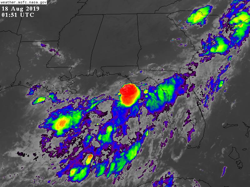
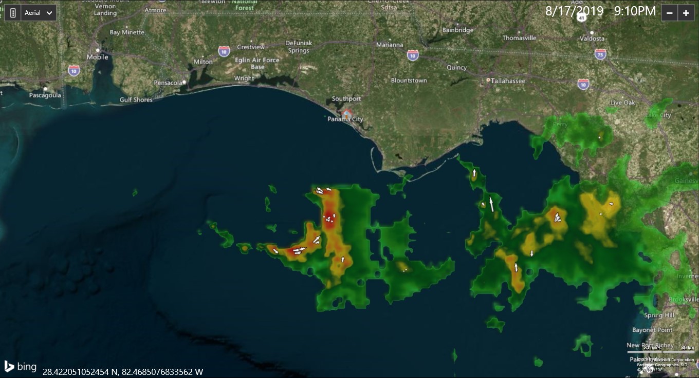
I agree with everyone. That this should be at least an invest..

But more likely its a td.. borderline ts..
Last edited by Aric Dunn on Sat Aug 17, 2019 9:13 pm, edited 1 time in total.
1 likes   
Note: If I make a post that is brief. Please refer back to previous posts for the analysis or reasoning. I do not re-write/qoute what my initial post said each time.
If there is nothing before... then just ask :)

Space & Atmospheric Physicist, Embry-Riddle Aeronautical University,
I believe the sky is falling...

User avatar
GCANE
S2K Supporter
S2K Supporter
Posts: 11453
Joined: Mon Oct 22, 2007 8:03 am

Re: N GOM Watch Part 2

#78 Postby GCANE » Sat Aug 17, 2019 9:12 pm

Bigger tower firing off now, lightning galor.
0 likes   

User avatar
tropicwatch
Category 5
Category 5
Posts: 3364
Age: 61
Joined: Sat Jun 02, 2007 10:01 am
Location: Panama City Florida
Contact:

Re: N GOM Watch Part 2

#79 Postby tropicwatch » Sat Aug 17, 2019 9:16 pm

With this kind of radar signature and it influencing shower activity pretty far to the east with them moving from south to north. I wouldn't be surprised if we see a special TWO issued.

Image
1 likes   
Tropicwatch


Agnes 72', Eloise 75, Elena 85', Kate 85', Charley 86', Florence 88', Beryl 94', Dean 95', Erin 95', Opal 95', Earl 98', Georges 98', Ivan 2004', Arlene 2005', Dennis 2005', Ida 2009' Debby 2012' Irma 2017' Michael 2018'

USTropics
Category 5
Category 5
Posts: 2635
Joined: Sun Aug 12, 2007 3:45 am
Location: Florida State University

Re: N GOM Watch Part 2

#80 Postby USTropics » Sat Aug 17, 2019 9:17 pm

It's right on the edge of radar range so hard to tell what level it's at, but evident circulation building:
Image
0 likes   


Return to “Talkin' Tropics”

Who is online

Users browsing this forum: No registered users and 92 guests